Hiking in Kobuk Valley: The Great Kobuk Sand Dunes
A careful guide to hiking the Great Kobuk Sand Dunes, with a reviewed route-area map, elevation profile, bush-plane access, river-to-dunes navigation, bear storage, and live NPS updates.
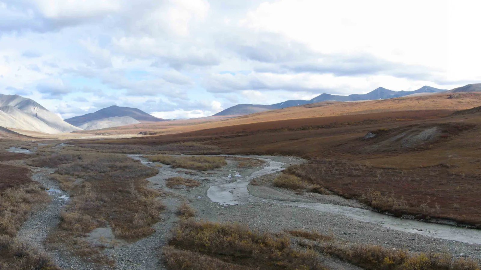
Kobuk Valley does not have a trail list to rank. There are no roads into the park, no maintained paths, no signs, no campground, and no services after the airplane leaves. Most hiking trips depend on a charter flight from Kotzebue or Bettles and enough spare food to wait out weather that can delay pickup.
The Great Kobuk Sand Dunes are the clearest hiking objective. A wheeled aircraft may land on firm sand, after which day walks can head in any direction. A floatplane can instead land on the Kobuk River; NPS describes the crossing from the river to the dunes as roughly two to three miles each way and about four hours round trip. That option is an off-trail navigation exercise through tundra, not a marked approach.
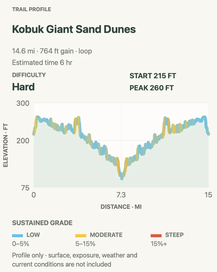
The reviewed map below follows one recorded 14.7-mile loop through the broader dune field. It is useful for scale, relief, and seeing how the dunes sit between ponds, tundra, and the river corridor. It is not an NPS route recommendation. Wet sand, brush, water levels, aircraft landing choices, wildlife, and visibility can all change the safe line on the day.
What changes a hiking day here
Confirm the landing plan before leaving town
Give the air taxi the party size, gear weight, intended camp area, pickup window, and missed-pickup procedure. Ask whether the pilot expects to land on the sand or water. Carry the shelter, insulation, food, and medication needed for several extra days because fog and wind can ground a small aircraft.
Treat the river approach as navigation
The two-to-three-mile crossing from the Kobuk River has no trail. Carry a paper topographic map, compass, GPS with spare power, and the skill to use them together. Dense vegetation and soft tundra can slow the return, so set a turnaround time that protects the pickup window.
Avoid saturated sand beside water
NPS warns that sand near streams, springs, creeks, and other wet areas can lose stability. Probe uncertain ground with a pole, give dark or glossy patches room, and retreat if a foot begins to sink. A dry-looking dune route can change quickly near a drainage.
Carry bear-resistant food storage
Both brown and black bears live here. Keep food, trash, toiletries, and cooking gear secured whenever they are not in hand. Bear-resistant containers may be borrowed from the Northwest Arctic Heritage Center in Kotzebue, subject to availability; arrange one before the flight rather than counting on an improvised hang in sparse country.
| Trail | Distance | Time | Difficulty | Best for |
|---|---|---|---|---|
| Great Kobuk Sand Dunes Backcountry Route | Recorded line: 14.7 miles; shorter walks are route dependent | NPS estimates about 4 hours round trip from the river to the dunes; allow a full day or camp for the recorded loop | Hard wilderness travel | Self-reliant hikers who can navigate trackless tundra and dunes and wait safely through an aircraft delay |
Great Kobuk Sand Dunes Backcountry Route
- Distance
- Recorded line: 14.7 miles; shorter walks are route dependent
- Elevation gain
- 760 feet
- Time
- NPS estimates about 4 hours round trip from the river to the dunes; allow a full day or camp for the recorded loop
- Difficulty
- Hard wilderness travel
- Route type
- Unmarked loop overview
- Parking
- There is no road trailhead. Arrange an authorized air-taxi landing and pickup from Kotzebue or Bettles; the exact starting point depends on aircraft, weather, water, and surface conditions.
- Best time
- Summer into early fall when the air taxi, river, fire outlook, insects, weather, and landing surface all support travel.
- Pets
- This is poor terrain for a casual dog hike. Aircraft rules, bears, heat on exposed sand, scarce water, and emergency transport all need to be settled with the carrier and park staff before bringing an animal.
A flight straight to the Great Kobuk Sand Dunes creates the simplest walking day. Once the pilot has confirmed a safe landing and pickup place, firm sand allows an open-ended loop with broad views. Distances are deceptive because there are no trail signs or fixed destinations. Save the aircraft location as a waypoint, note a compass bearing before leaving, and turn back while the return still has generous time.
The river approach is a different trip. NPS describes a two-to-three-mile crossing from the Kobuk River to the dunes that may take about four hours round trip. The ground between them can include brush, tussocks, ponds, soft tundra, and wet sand. Straight-line distance is a poor time estimate. A floatplane landing also ties the outing to water conditions and a specific pickup point that may be harder to see on the return.
The longer recorded line in our map crosses much more of the dune system. It begins near the river side, travels northwest through pale active sand, and returns on a separate leg. Use it to understand the size of the field, not as a promise of firm footing or a command to trace every bend. Clouds, water, bear sign, vegetation, and the pilot's landing location may make a shorter day far more sensible.
Summer conditions can swing from cold rain to very hot exposed sand; NPS notes that air temperatures on the dunes can reach 100°F. There is little shade and water sources can be silty or separated from the chosen line. Carry more treated water than a normal arctic forecast might suggest, then keep rain layers and insulation accessible. Mosquitoes and black flies add another reason to cover skin rather than relying only on repellent.
Camp only on a level surface outside obvious travel corridors, low drainages, and wet sand. Separate sleeping, cooking, and food-storage areas. Respect private land and subsistence activity along the Kobuk River: signs of cabins, camps, equipment, or active use are reasons to detour widely. No permit is required for an independent visit, but organized recreational groups may need one.
What helps on this route
- Call the Northwest Arctic Heritage Center and the air taxi shortly before departure for weather, fire, wildlife, and landing information.
- Carry satellite communication, a written trip plan, and enough food for a delayed pickup; cell service should not be expected.
- Record the aircraft location on two devices and on the paper map before walking away.
- Give wet sand near streams, springs, and pond edges a wide berth.
- Keep the map below in the planning role it can support; navigate from current ground conditions once in the park.
Terrain and access: Trackless arctic dunes, tundra, tussocks, brush, ponds, wet sand, exposed heat, cold rain, bear habitat, and no facilities or reliable cell service.

Official planning sources
Trail access and safety details were checked against these National Park Service pages. The maps and profiles use the reviewed route geometry stored with this guide.
- NPS: Great Kobuk Sand Dunes access and saturated-sand warning
- NPS: Current alerts and bear encounter reporting
- NPS: Roadless access by authorized air taxi
- NPS: Backcountry hiking and camping
- NPS: Remote travel safety and navigation
- NPS: Bear-resistant containers and permits
- NPS: Northwest Arctic Heritage Center hours and trip help
- NPS: Park access and respect for private land
Map data © OpenStreetMap contributors. Trail geometry and planning details include National Park Service public information.