2 Best Hikes in Kenai Fjords National Park
The two maintained Kenai Fjords hikes: a short Exit Glacier loop and the steep climb to the edge of Harding Icefield.
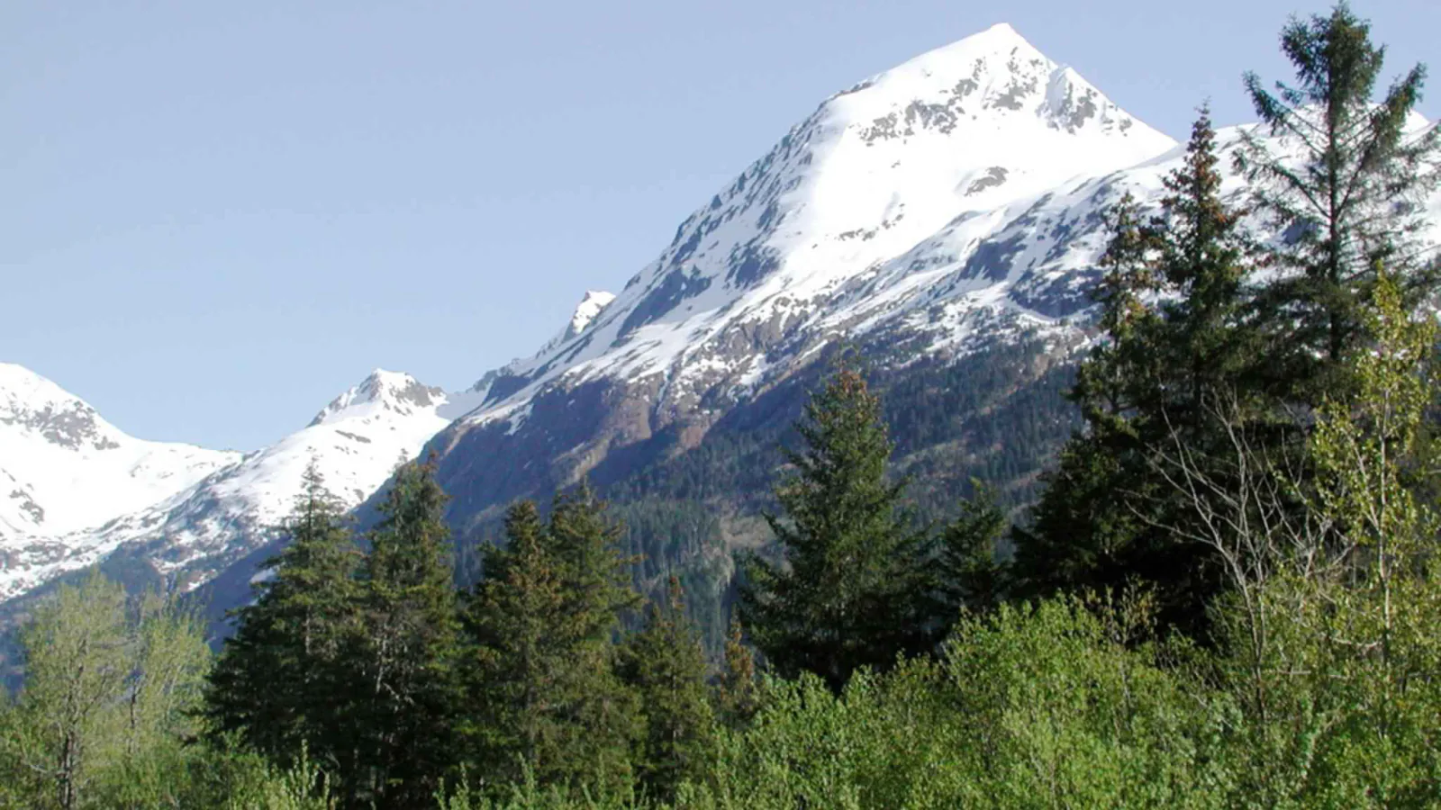
Most of Kenai Fjords cannot be reached on foot from a road. Ice, mountains, and more than 500 miles of coast define the park, while its maintained trail system fits into one valley outside Seward. A list of eight or ten hikes would quietly borrow routes from neighboring public land or send readers onto unmarked coastal ground.
There are two trail decisions. The Exit Glacier loops make a short, accessible-to-moderate visit below the ice. Harding Icefield Trail climbs roughly 3,100 feet above the same valley and consumes most of a day. Their trailheads are beside each other, but the physical demands are nowhere close.
This guide was checked on August 29, 2026. Herman Leirer Road was open to cars and the lower Exit Glacier trails were clear of snow. The park's most recent Harding report, dated July 16, still noted snow past Top of Cliffs. Conditions can change sharply at this latitude; use the live report, not the date on an article, before committing to the upper trail.
What changes a hiking day here
Arrive outside the parking crush
The road ends at the Exit Glacier Nature Center about 8.4 miles from the Seward Highway. Parking is often tight from roughly 10 a.m. to 3:30 p.m. in June, July, and August. An early start helps both the parking problem and the Harding climb; Seward shuttles and taxis are alternatives.
Stay out of the closed glacier canyon
The canyon from the toe of Exit Glacier to the lower outwash plain is closed because a glacial outburst can send water, ice, rock, and debris through it without a weather warning. The designated trails avoid that hazard. Do not leave them to approach the ice.
Carry a wet-cold kit in summer
The valley is a coastal rainforest and the upper ridge can be windy, snowy, or bright in the same outing. Pack rain gear, a warm layer, gloves, sun protection, food, and at least two liters of water for Harding. A stream is not safe drinking water until treated.
Plan for bears and no phone signal
Black bears feed in the alder and salmonberry thickets. Carry bear spray where it can be reached, talk on blind bends, and back away if a bear occupies the trail. Cell service and public Wi-Fi are absent in the Exit Glacier area, so save the route and emergency information before driving out.
Leave pets off the trails
Pets may use Herman Leirer Road and the nature-center parking lot while leashed. They are prohibited on both hiking routes, in the campground, in public-use cabins, and through much of the coastal backcountry.
| Trail | Distance | Time | Difficulty | Best for |
|---|---|---|---|---|
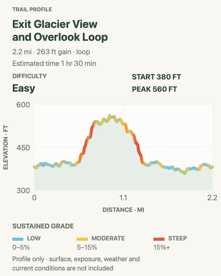
| Exit Glacier View and Overlook Loop | About 2.2 miles when the accessible loop and overlook spur are combined | 1 hr 30 min | Easy | Families, the park's accessible Glacier View path, and a short look into the Exit Glacier valley |
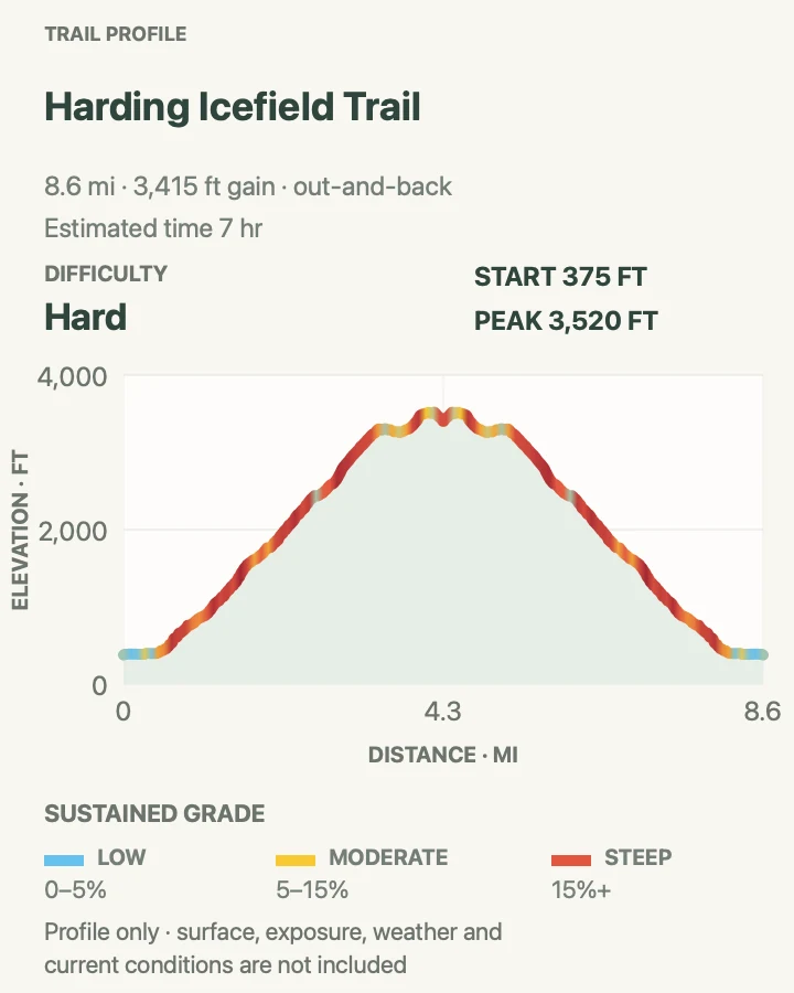
| Harding Icefield Trail | 7.8 miles out and back | 7 hr | Hard | A hard full-day climb from rainforest to a view across the Harding Icefield |
Exit Glacier View and Overlook Loop
- Distance
- About 2.2 miles when the accessible loop and overlook spur are combined
- Elevation gain
- 260 feet
- Time
- 1 hr 30 min
- Difficulty
- Easy
- Route type
- loop
- Parking
- Use the Exit Glacier Nature Center lot at the end of Herman Leirer Road; arrive early or use a Seward shuttle when summer parking is full.
- Best time
- A summer morning after the road opens, or a dry afternoon when the glacier is clear of low cloud.
- Pets
- Pets are prohibited on the Exit Glacier trails.
Start left of the nature center on the one-mile Glacier View Loop. The broad paved path passes through young cottonwood forest to an open view of Exit Glacier spilling from the Harding Icefield. Continue at the signed junction for the unpaved Glacier Overlook spur if the group wants a closer angle and can handle a moderate climb.
The glacier has retreated away from places once reached by older paths. Today the designated overlook is the destination. The route does not reach or touch ice, and the canyon below is closed for glacial-outburst danger. Return by the loop rather than following informal tracks onto the outwash plain.
What helps on this route
- Do the paved Glacier View Loop alone if wheels, energy, or weather make the overlook spur a poor fit.
- Stop at the dated glacier markers near the valley path; they put the current view in useful context without adding distance.
Terrain and access: Paved accessible loop, then a maintained dirt spur with roots, short grades, wet forest, bear habitat, rain exposure, and a signed glacier overlook.

Harding Icefield Trail
- Distance
- 7.8 miles out and back
- Elevation gain
- 3,420 feet
- Time
- 7 hr
- Difficulty
- Hard
- Route type
- out-and-back
- Parking
- Use the Exit Glacier Nature Center lot and follow the overlook path to the signed Harding trail register.
- Best time
- A stable midsummer morning after reading the same-day snow, avalanche, and road reports.
- Pets
- Pets are prohibited on Harding Icefield Trail.
Harding begins gently enough, then settles into its real pattern: close to 1,000 feet of climbing per mile. The route rises through cottonwood and alder, reaches Marmot Meadows near 1.5 miles, then crosses exposed slopes toward Top of Cliffs and the end-of-trail viewpoint. Turnarounds at the meadow or cliffs still give a strong view of Exit Glacier when time or snow closes the upper mile.
Allow six to eight hours for the full trip. Snow can cover the route into July or later, hiding streams and leaving weak bridges underfoot. Orange flags may mark buried tread, but flags do not remove avalanche risk. Past a posted avalanche warning, continue only with the training and equipment to judge that terrain.
Bears are common in the lower berry thickets, and the upper ridge offers little shelter from wind or sudden rain. Carry bear spray, make noise, keep food contained, and pack out all rubbish and toilet paper. The small shelter near the top is for emergencies, not camping.
What helps on this route
- Register at the trailhead and tell someone in Seward when you expect to return; there is no cell service.
- Trekking poles help on mud and old snow. Bring a filter if the carried two-liter minimum will not be enough.
Terrain and access: Steep forest switchbacks, wet roots, berry thickets, alpine meadow, exposed rock, lingering snow, possible avalanche terrain, roughly 3,100 feet of climbing, and rapid coastal weather.

Official planning sources
Trail access and safety details were checked against these National Park Service pages. The maps and profiles use the reviewed route geometry stored with this guide.
Map data © OpenStreetMap contributors. Trail geometry and planning details include National Park Service public information.