Hiking in Gates of the Arctic: The Arrigetch Peaks Route
A careful planning guide to the Arrigetch Peaks backcountry route, with a reviewed overview map, elevation profile, current bear warning, access logistics, and live park alerts.
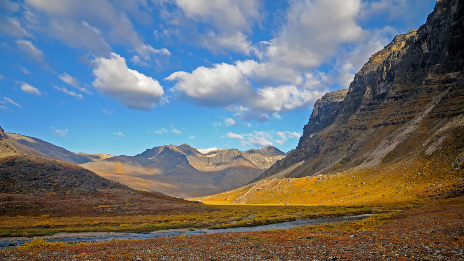
Gates of the Arctic has no road entrance, maintained trail system, campground, or reliable phone service. A hiking guide that pretends otherwise would be dangerous. Most visits begin with a charter flight and become self-supported wilderness trips where tussocks, brush, bog, river crossings, weather, and landing conditions decide the pace.
The reviewed library holds one Arrigetch Peaks line, so this page covers that expedition in depth instead of manufacturing a numbered list. Its map is an overview of one recorded corridor. Granite passes and valley routes have no signs, tracks may disappear, and the safest line changes with water, visibility, bear activity, and the party's skills.
A current NPS warning dated August 13, 2026 reports a food-conditioned brown bear entering camps and food caches in the Arrigetch Peaks area. The park strongly recommends hard-sided bear-resistant food containers there. Hard canisters are available at Bettles Ranger Station, subject to availability. Contact park staff and the air taxi before committing to this route.
Live park weather
Gates of the Arctic National Park
Anaktuvuk Pass Ranger Station
Loading the latest conditions and alerts…
What changes a hiking day here
Build the schedule around the airplane
Air taxis may be unable to fly in low cloud, wind, smoke, or poor landing conditions. Carry several extra days of food, leave a written trip plan with the pilot and a trusted contact, and agree on missed-pickup procedures before departure.
Navigate beyond the recorded line
There are no established trails. The reviewed map gives scale and a known corridor, but it cannot show current braids, brush, erosion, snow, or a safe river crossing. Every traveler should carry a paper topographic map, compass, and the skill to use both in low visibility.
Carry two independent communication methods
NPS recommends two forms of backcountry communication. A satellite messenger paired with a satellite phone or personal locator beacon gives redundancy, but none replaces self-rescue, spare medication, repair gear, and conservative decisions.
Use a hard-sided food canister
Bear-resistant storage is required for overnight trips. In the Arrigetch, the current food-conditioned bear warning makes a hard canister the prudent choice. Cook, store food, and sleep in separate areas and keep every scented item under direct control.
| Trail | Distance | Time | Difficulty | Best for |
|---|---|---|---|---|
| Arrigetch Peaks Backcountry Route | About 27 miles, route dependent | Multi-day expedition | Expert wilderness travel | Experienced, self-reliant parties seeking granite valleys and trackless Brooks Range travel |
Arrigetch Peaks Backcountry Route
- Distance
- About 27 miles, route dependent
- Elevation gain
- 4,210 feet
- Time
- Multi-day expedition
- Difficulty
- Expert wilderness travel
- Route type
- Unmarked out-and-back corridor
- Parking
- There is no road trailhead. Arrange a legal air-taxi drop-off and pickup with a transporter experienced in the Arrigetch area.
- Best time
- Summer into early fall when the transporter, river levels, fire conditions, and mountain forecast all support travel.
- Pets
- Pets are a poor fit for this trackless bear-country expedition; discuss any animal with NPS and the air carrier before planning.
The Arrigetch route moves from a remote landing area into the granite valleys below the peaks. The stored line covers roughly 27 miles out and back, but actual travel will vary as hikers choose firm tundra, gravel bars, safe crossings, and camps that avoid bear sign. Dense willow and tussocks can reduce progress to a fraction of ordinary trail speed.
This is also mountaineering country. The route map does not authorize a summit line or indicate stable rock, snow bridges, avalanche exposure, or a safe pass. Technical objectives require separate judgment, equipment, and experience. A hiking party can make a complete trip by staying in valleys and enjoying the granite walls from below.
The August 2026 bear incident changes camp practice. Carry a hard-sided canister, never leave food unattended, and move camp if tracks, scat, digging, a carcass, or repeated bear travel appears nearby. Make noise in brush and beside loud streams, where neither hikers nor bears can hear the other well.
River crossings deserve their own turnaround rules. Water that was manageable on arrival can rise after rain or warm weather. Search upstream and downstream for a broad, shallow braid, unbuckle the pack, and wait when speed, depth, cold, or poor footing makes the crossing uncertain. A delayed pickup is preferable to a forced ford.
What helps on this route
- Attend a backcountry and bear-safety orientation in Fairbanks, Bettles, Coldfoot, or Anaktuvuk Pass before the flight.
- Carry repair supplies for shelter, stove, footwear, and water treatment; there is no quick resupply.
- Give the pilot a written route, camp options, communication devices, and the time to start an overdue response.
- Treat the map below as regional context, then navigate from current terrain and large-scale topographic sheets.
Terrain and access: No maintained trail, tundra tussocks, bog, dense willow, gravel bars, cold rivers, talus, granite valleys, severe weather, bear habitat, and no routine rescue or cell service.

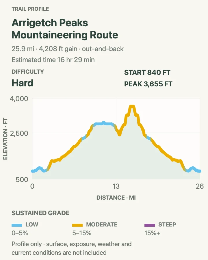
Official planning sources
Trail access and safety details were checked against these National Park Service pages. The maps and profiles follow the corresponding route geometry.
- NPS: Current Arrigetch Peaks bear warning
- NPS: Alerts and bear encounter reporting
- NPS: Backcountry hiking without trails
- NPS: Wilderness safety and required food storage
- NPS: Bear awareness and camp practice
- NPS: Backcountry communications
- NPS: No roads or marked trails
- NPS: Park brochure and undeveloped conditions
Map data © OpenStreetMap contributors. Trail geometry and planning details include National Park Service public information.