3 Best Hikes in Glacier Bay National Park and Preserve
Three Glacier Bay hikes spanning Bartlett Cove forest, a remote lake, and the Dry Bay preserve, with reviewed maps, profiles, bear advice, and live park alerts.
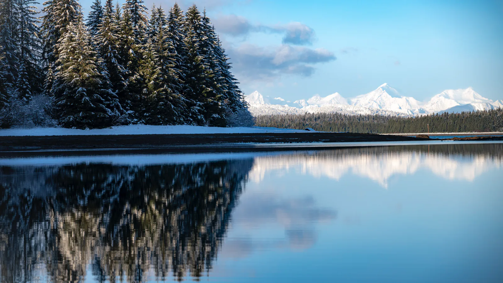
Glacier Bay is mostly water and wilderness, not a road-trail park. Bartlett Cove is its one developed area, ten road miles from Gustavus, and it holds the only maintained day-hiking network. Reaching the preserve at Dry Bay is a separate expedition by aircraft or the Alsek River.
This guide therefore has three routes. Bartlett River is the approachable forest-and-estuary day; Bartlett Lake is the longer, rougher branch through old moraine; Walker Glacier is a remote preserve approach for people who already have Dry Bay transport and local advice. Several appealing routes remain unpublished until their maps pass visual review.
Rain, mud, bears, moose, salmon, and tides all change travel here. Glacier Bay can move through a 25-foot tidal range in six hours, while a wooded path that seems empty may hold fresh bear sign. Check park alerts, speak with the Visitor Information Station, and carry rain gear even when Gustavus begins dry.
What changes a hiking day here
Wear boots that accept mud
Bartlett Cove trails cross wet forest, roots, mossy rock, and low ground. Waterproof boots improve comfort, but traction matters more than keeping clean. Slow down on roots and boardwalk after rain.
Make noise before visibility disappears
Black and brown bears use the forests and shorelines. Talk in brush, beside running water, and around blind bends; travel in a group when possible; keep food within reach; and never run from a bear.
Check tides for any shore extension
A low-tide flat can vanish quickly, and high water may press people into brush used by wildlife. Use local tide predictions, note the 25-foot range, and leave the shore well before the return route narrows.
Do not blur Bartlett Cove and Dry Bay
The two districts have no connecting visitor road. Dry Bay has NPS airstrips and Alsek River operations, while Bartlett Cove is reached through Gustavus. Confirm transport, permits, and pickup before treating the preserve route as available.
| Trail | Distance | Time | Difficulty | Best for |
|---|---|---|---|---|
| Bartlett River Trail | 4 to 5 miles | 4 to 5 hours | Easy | Temperate rainforest, intertidal lagoon, and wildlife at an estuary |
| Bartlett Lake Trail | About 8 miles | 7 to 8 hours | Moderate | A quiet lake reached through rough rainforest and glacial moraine |
| Walker Glacier Approach in Dry Bay Preserve | 4.1 mi | 3 hr | Hard | Experienced visitors already traveling through the remote Alsek and Dry Bay preserve |
Bartlett River Trail
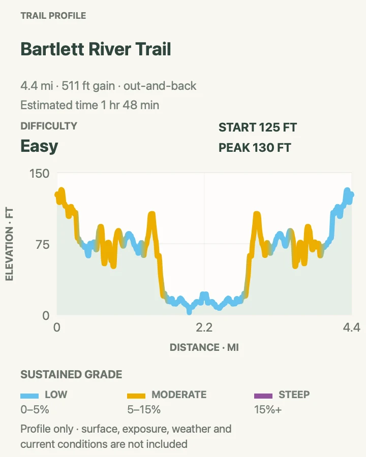
- Distance
- 4 to 5 miles
- Elevation gain
- 510 feet
- Time
- 4 to 5 hours
- Difficulty
- Easy
- Route type
- out-and-back
- Parking
- Begin near Glacier Bay Lodge in Bartlett Cove; use designated visitor parking and follow signs shared with Bartlett Lake.
- Best time
- A dry morning, with late summer offering salmon and more wildlife activity near the estuary.
- Pets
- Pets are not allowed on park trails. Trained service animals are allowed.
Bartlett River meanders beside an intertidal lagoon, passes through spruce and hemlock forest, and ends at the river estuary. The NPS route is about four miles round trip, though walking from different lodge points can produce a slightly longer track like the reviewed map below.
Ducks, geese, otters, seals, moose, and bears all use the water and forest. Salmon later in summer can concentrate predators. Make noise before entering brush, keep food packed, and give the estuary to wildlife if activity is close.
What helps on this route
- Photograph the junction where Bartlett Lake branches away after roughly a quarter mile.
- Turn around before high tide crowds the estuary edge or removes comfortable shoreline footing.
Terrain and access: Muddy forest tread, roots, mossy rock, lagoon edge, intertidal estuary, wildlife habitat, limited cell service, and little elevation gain.

Bartlett Lake Trail
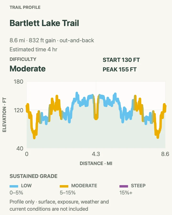
- Distance
- About 8 miles
- Elevation gain
- 830 feet
- Time
- 7 to 8 hours
- Difficulty
- Moderate
- Route type
- out-and-back
- Parking
- Start near Glacier Bay Lodge and take the Bartlett River Trail to the signed lake junction about a quarter mile in.
- Best time
- A long summer day with a stable forecast and enough daylight for slow, wet footing.
- Pets
- Pets are not allowed on park trails. Trained service animals are allowed.
The lake branch climbs onto old moraine and winds among moss-covered boulders, roots, and lichen-draped trees. It is less maintained than the river trail and can be difficult to follow where vegetation or fallen timber interrupts the tread.
Eight miles here can fill a day. Carry lunch, treated water, rain gear, and an offline map. Pause at uncertain sections and find the continuing tread instead of trampling a new line through moss or wet ground.
What helps on this route
- Set a turnaround time that leaves room for slow route finding on the return.
- Treat all water even when it appears clear and cold.
Terrain and access: Less-maintained rainforest trail, moraine, mossy boulders, roots, mud, possible deadfall, bear habitat, and a remote lake shore.

Walker Glacier Approach in Dry Bay Preserve
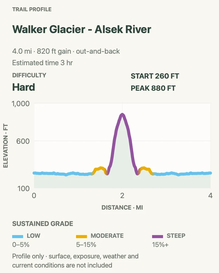
- Distance
- 4.1 mi
- Elevation gain
- 820 feet
- Time
- 3 hr
- Difficulty
- Hard
- Route type
- out-and-back
- Parking
- There is no ordinary road trailhead. Arrange legal Dry Bay or Alsek access through an authorized operator and confirm the exact pickup location.
- Best time
- Only when local river, airstrip, flood, bear, and glacier conditions have been checked with the park and operator.
- Pets
- Pets are not allowed on park trails. Trained service animals are allowed.
This recorded four-mile approach lies in the preserve near the Alsek River, far from Bartlett Cove. Dry Bay has two NPS airstrips and is also the takeout area for permitted Alsek and Tatshenshini river trips. Access, water channels, and usable ground vary from season to season.
The map is a planning record, not an invitation to walk onto glacier ice. Glaciers contain crevasses, unstable margins, meltwater channels, and falling debris that the profile cannot show. Stay on safe ground unless traveling with the equipment and knowledge for glacial terrain.
Designated preserve vehicle routes can also change with high water, shifting sand, and nesting birds. Confirm current rules and conditions before leaving an airstrip or river camp, and carry communications suitable for a place with delayed emergency response.
What helps on this route
- Contact the park's Alsek information desk before booking transport or river travel.
- Use the reviewed line for scale, then follow current operator and ranger direction on the ground.
- Carry a bear-resistant food container for any overnight stay outside forested areas.
Terrain and access: Remote river plain, shifting channels, wet ground, brush, glacial outwash, bear habitat, no public road connection, air or river access, and possible glacier hazards.

Official planning sources
Trail access and safety details were checked against these National Park Service pages. The maps and profiles use the reviewed route geometry stored with this guide.
- NPS: Bartlett Cove hiking routes
- NPS: Glacier Bay alerts and planning
- NPS: Bears, tides, water, and moose safety
- NPS: Bartlett Cove trail maps
- NPS: Dry Bay and Alsek preserve access
- NPS: Camping, permits, and bear storage
- NPS: Seasonal permit requirements
- NPS: Pet and service-animal rules
- NPS: Getting to Bartlett Cove
Map data © OpenStreetMap contributors. Trail geometry and planning details include National Park Service public information.