3 Best Walks at Gateway Arch National Park
Three useful walking circuits through the Gateway Arch grounds, riverfront, lawns, and ponds, with reviewed maps, profiles, accessibility notes, and live park alerts.

Gateway Arch National Park does not need a padded hiking list. Its grounds cover about 91 acres in downtown St. Louis, and the useful question is how much of the monument, riverfront, plantings, and historic district you want to see on foot.
These three circuits overlap on purpose. The inner loop stays close to the Arch and west entrance. The 1.6-mile loop reaches the river and opens better views back to the monument. North Pond makes a quieter short walk through trees and water north of the central lawns. Each map shows the actual choice rather than pretending the park contains three separate trail systems.
The grounds are open from 5 a.m. to 11 p.m. year-round. As of 2026, the visitor center and museum use the west entrance facing Fourth Street and the Old Courthouse; the Arch legs are exits only. Building entry requires airport-style screening, so finish the walk at least 30 minutes before a reserved tram time.
What changes a hiking day here
Do the outdoor circuit before security
The museum and tram lobby sit behind a screening checkpoint, and there are no lockers. Walk first, return to the west entrance, and allow at least 30 minutes before a booked tram. Pepper spray and other weapons cannot pass screening.
Use the ramps for an accessible riverfront loop
The paved paths across the grounds are accessible. The grand staircase to Leonor K. Sullivan Boulevard has about 65 steps, but ramps on the north and south sides provide the step-free connection to the riverfront.
Plan around downtown events
The park operates no visitor parking lot, and Cardinals games or riverfront events can change garage demand, street closures, and crowd patterns. Check the current park alert and city event calendar before driving downtown.
Treat summer as an early-or-late walk
St. Louis heat and humidity can be intense. The lawns offer some tree shade, but riverfront pavement is exposed. Morning and evening are calmer, cooler, and often better for unobstructed photographs.
| Trail | Distance | Time | Difficulty | Best for |
|---|---|---|---|---|
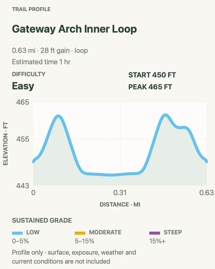
| Gateway Arch Inner Loop | 0.6 mi | 1 hr | Easy | A concise circuit beneath the monument |
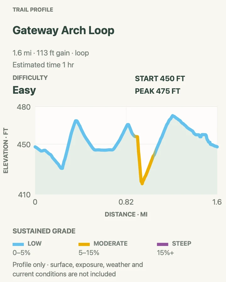
| Gateway Arch Grounds and Riverfront Loop | 1.6 mi | 1 hr | Easy | The fullest on-foot view of the Arch, Mississippi, and designed grounds |
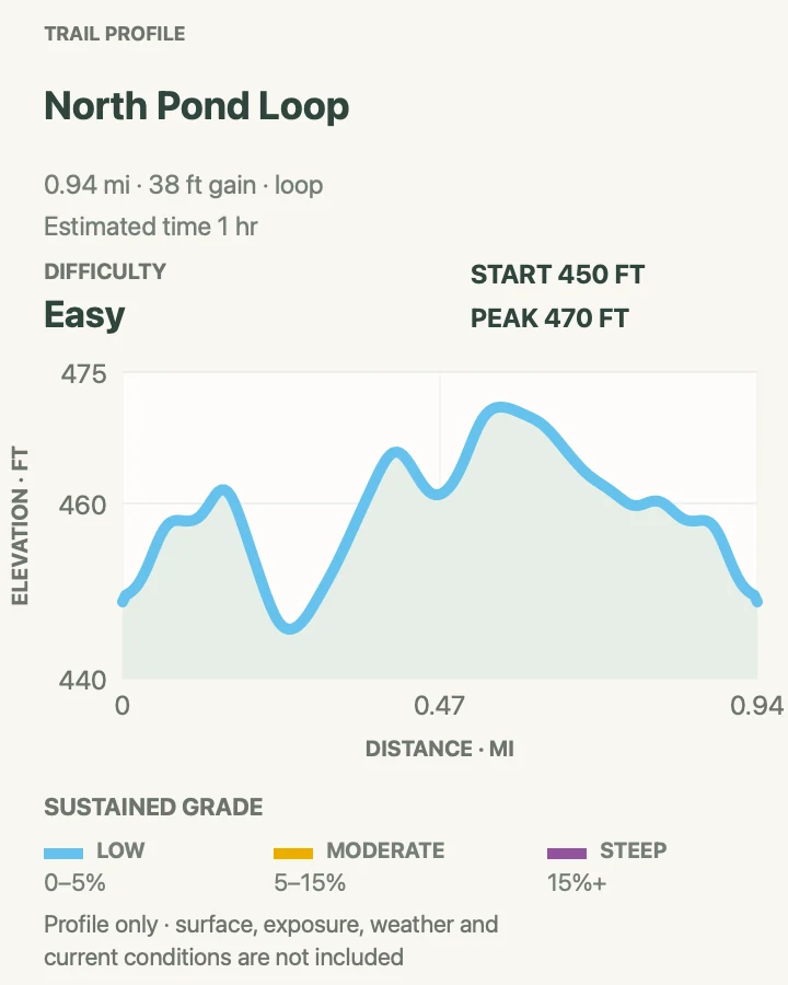
| North Pond Loop | 0.9 mi | 1 hr | Easy | Trees, pond reflections, and a quieter short circuit |
Gateway Arch Inner Loop
- Distance
- 0.6 mi
- Elevation gain
- 30 feet
- Time
- 1 hr
- Difficulty
- Easy
- Route type
- loop
- Parking
- Use a downtown garage or transit, then begin at the west entrance between the Old Courthouse and the Arch.
- Best time
- Early morning for quiet grounds, or before a reserved museum and tram visit.
- Pets
- Leashed pets are welcome outdoors on a leash no longer than six feet; only service animals may enter park buildings.
The inner loop circles the base of the Arch on paved paths, crossing the central lawns and passing both stainless-steel legs. At six-tenths of a mile, it leaves time to touch the monument, study its changing curve from several angles, and return to the west entrance without hurrying.
This is the practical choice with a fixed tram time or limited walking tolerance. It remains exposed in midday sun, and visitor groups often gather near the legs. A slow circuit around the outer edge of the lawn is usually calmer than cutting straight through the center.
What helps on this route
- Keep the west entrance in mind; the doors at the Arch legs are exits.
- Step back from the base to see how the apparent width changes around the curve.
Terrain and access: Smooth paved paths, broad lawn edges, almost level grade, full urban access, limited shade near the monument, and heavy foot traffic at midday.

Gateway Arch Grounds and Riverfront Loop
- Distance
- 1.6 mi
- Elevation gain
- 110 feet
- Time
- 1 hr
- Difficulty
- Easy
- Route type
- loop
- Parking
- Approach from a downtown garage, MetroLink station, or hotel and start at Luther Ely Smith Square or the west entrance.
- Best time
- Morning or evening in warm weather; avoid the busiest event and game periods.
- Pets
- Leashed pets are allowed throughout the outdoor grounds but cannot enter the visitor center or Old Courthouse.
The longer loop uses the west paths, circles the lawns, and drops to Leonor K. Sullivan Boulevard beside the Mississippi before returning around the opposite side. The riverfront distance gives the monument enough room to read as a complete shape rather than an object overhead.
Choose the north or south ramp for a step-free connection to the levee. The grand staircase is direct but adds roughly 65 steps. Cobblestones, river spray, summer heat, and occasional flooding can make the lowest riverfront section less comfortable than the lawns above.
What helps on this route
- Walk toward the river first if the water level or a temporary closure may affect the lower section.
- Allow extra time for the Old Courthouse, which is open daily from 9 a.m. to 5 p.m.
Terrain and access: Paved grounds, accessible ramps, optional large staircase, exposed riverfront boulevard, cobblestone edges, broad lawns, and modest urban grade changes.

North Pond Loop
- Distance
- 0.9 mi
- Elevation gain
- 40 feet
- Time
- 1 hr
- Difficulty
- Easy
- Route type
- loop
- Parking
- Enter from the city side and use the north network of paved paths; no visitor parking is provided inside the park.
- Best time
- Early morning, spring bloom, or a still evening for reflections.
- Pets
- Leashed pets are welcome outdoors; keep them out of ponds and garden beds and carry out waste.
North Pond shifts attention from the monument's base to the park's water, trees, and curved paths. The Arch still appears above the plantings, but the half-hour circuit feels removed from the central entry flow.
The route stays paved and nearly flat. Pond edges and wet leaves may be slick after rain, while summer mosquitoes gather around still water. Keep pets out of the pond and leave the planted banks undisturbed.
What helps on this route
- Use the pond as a short add-on after the inner loop rather than walking the same central paths twice.
- Visit just after sunrise for softer light and fewer school or tour groups.
Terrain and access: Accessible paved paths, pond edge, mature trees, gentle curves, wet-weather slick spots, planted banks, and an almost level profile.

Official planning sources
Trail access and safety details were checked against these National Park Service pages. The maps and profiles use the reviewed route geometry stored with this guide.
Map data © OpenStreetMap contributors. Trail geometry and planning details include National Park Service public information.