6 Best Hikes in Yosemite National Park
Six distinct Yosemite hikes with reviewed terrain maps, measured elevation profiles, Half Dome permit guidance, trailhead access, and live NPS conditions.
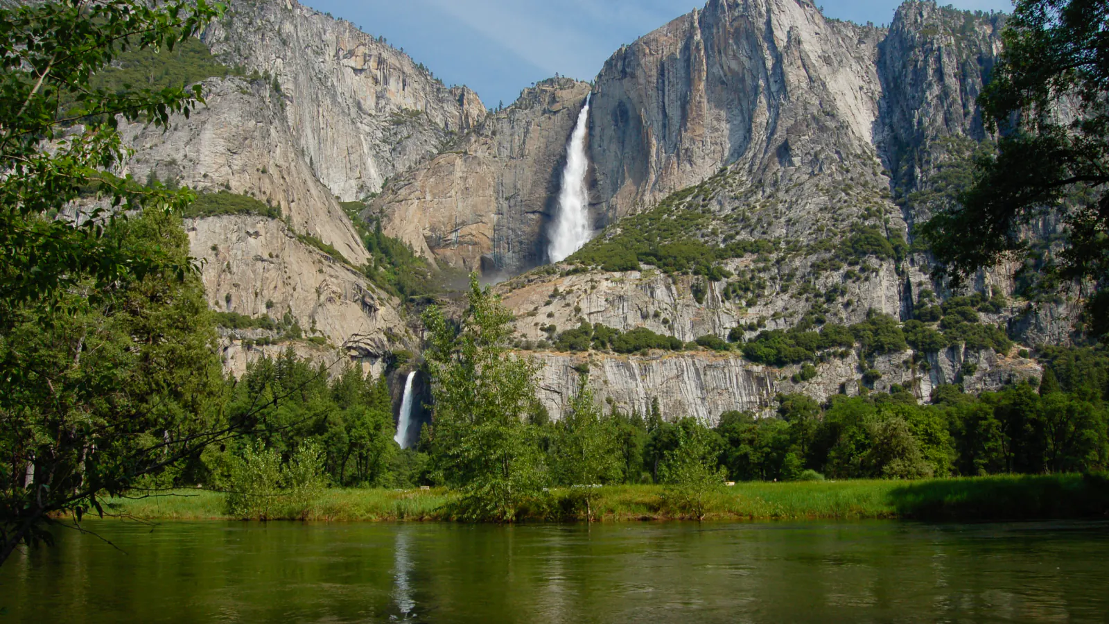
Yosemite's famous valley routes are close on a road map and far apart in effort. Lower Yosemite Fall is a paved walk measured in minutes. Upper Yosemite Fall gains more than 3,000 feet, while Half Dome turns the same Happy Isles approach used for the waterfall trails into a permit-controlled summit day. Choose by exposure, climbing, and access rather than by the landmark name alone.
These six hikes are the distinct route families supported by the preserved Yosemite source set after a geometry-based overlap review. Shorter Vernal Fall and Nevada Fall variants were removed because they repeat the selected combined waterfall itinerary. Half Dome is the deliberate exception: it shares the lower corridor but continues to a separate summit and a materially different objective. Distances and gains on each card follow the reviewed route geometry used for its map and profile, so they may differ from rounded NPS sign values.
Official conditions were checked on August 30, 2026. No entrance reservation is required in 2026. The Half Dome cables are up and a permit is required beyond the subdome. Through October, subject to change, weekday Mist Trail repair work normally routes hikers to the John Muir Trail between 7 am and 3:30 pm. Read the live alert and weather panels before leaving service because fire, rockfall, water, road, and trail conditions can change sooner than this page.
Live park weather
Yosemite National Park
Yosemite Valley Welcome Center
Loading the latest conditions and alerts…
What changes a hiking day here
Treat the Happy Isles routes as three different commitments
Vernal and Nevada Falls is a hard waterfall loop. Half Dome uses much of the same lower approach but adds a remote summit, roughly 5,300 feet of measured climbing, cables, and a permit checkpoint. Do not let the shared trailhead blur that difference. Carry a headlamp on either outing and set a turnaround time that protects the descent.
Use the 2026 Mist Trail detour schedule
NPS says the Mist Trail segment above the Vernal Fall footbridge is normally closed for repair Monday through Thursday from 7 am to 3:30 pm through October. It is normally open overnight, Friday through Sunday, and on holidays when safe. The John Muir Trail is the alternate route. Posted barriers and same-day alerts control, even when a saved map shows the usual line.
A Half Dome permit is part of the route
When the cables are up, every hiker continuing beyond the base of the subdome needs a Half Dome permit. Day permits are distributed through Recreation.gov lotteries, and the permit holder or alternate must be present with identification. Cables can close because of conditions, and a permit does not make wet granite, lightning, or fatigue safe.
Park once in Yosemite Valley
Parking is not available at Happy Isles or Mirror Lake. Use an open day-use lot and the free valley shuttle, or walk the paved paths. Lower Yosemite Fall and Upper Yosemite Fall use separate trailheads near Yosemite Valley Lodge and Camp 4. Full lots do not create permission to stop along road edges, in shuttle zones, or at closed pullouts.
Glacier Point Road is a separate hiking district
Sentinel Dome and Taft Point start high on Glacier Point Road, not in Yosemite Valley. The road is seasonal and can close for snow, fire, or hazard work. There is no regular valley shuttle to this trailhead. Confirm the road status before driving up and keep a lower-elevation backup route for a closure or thunderstorm day.
Waterfall edges are never swimming stops
The Merced River and waterfall channels can be cold, swift, and deceptively smooth near granite shelves. Stay behind railings and warning signs, remain on the established trail, and keep out of the water above falls. Mist makes the Vernal Fall steps slick; loose decomposed granite and crowded stairs add fall risk even when the river is lower.
Know the narrow pet exceptions
Leashed pets are allowed on the paved Lower Yosemite Fall loop and the paved road to Mirror Lake, but not on the unpaved Mirror Lake Loop or the other hiking trails in this guide. Pets are not allowed on park shuttles. A carried pet is still subject to the same restriction. Trained service animals may accompany visitors where the public can go.
Keep food within reach
Black bears investigate packs, picnic areas, and vehicles. During a day hike, keep food and scented items within arm's reach rather than leaving a pack beside the trail. Follow the vehicle storage rules before boarding a shuttle, dispose of waste in bear-resistant containers, and give wildlife room.
| Trail | Distance | Time | Difficulty | Best for |
|---|---|---|---|---|
| Lower Yosemite Fall Trail | About 1.2 miles around the reviewed loop | 30 minutes to 1 hour | Easy | A short, paved waterfall walk with a mobility-friendly eastern approach |
| Upper Yosemite Falls Trail | About 6.3 miles round trip on the reviewed track | 5.5 to 8 hours | Hard | A sustained climb from the valley floor to the north rim beside Yosemite Falls |
| Sentinel Dome and Taft Point Loop | About 5.2 miles around the reviewed loop | 2.5 to 4 hours | Moderate | Two south-rim viewpoints in one high-elevation circuit |
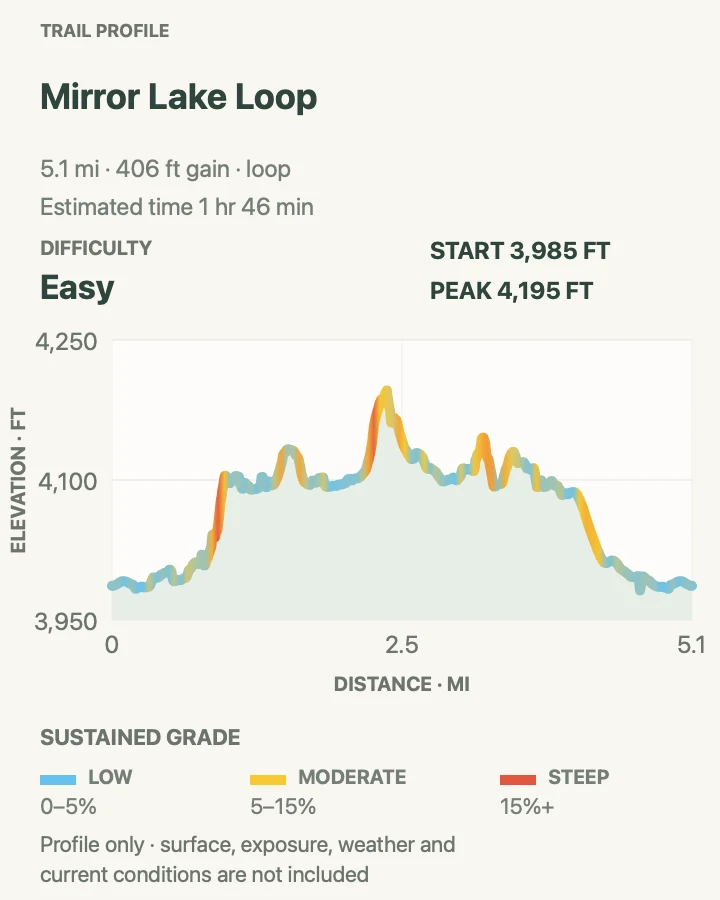
| Mirror Lake Loop | About 5.1 miles around the reviewed loop | 2 to 3 hours | Easy | A mostly gentle circuit beneath Half Dome along Tenaya Creek |
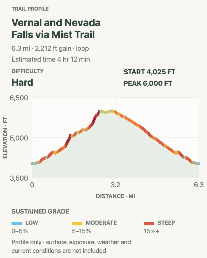
| Vernal and Nevada Falls via Mist Trail | About 6.3 miles around the reviewed loop | 4.5 to 7 hours | Hard | The full Vernal Fall and Nevada Fall waterfall circuit |
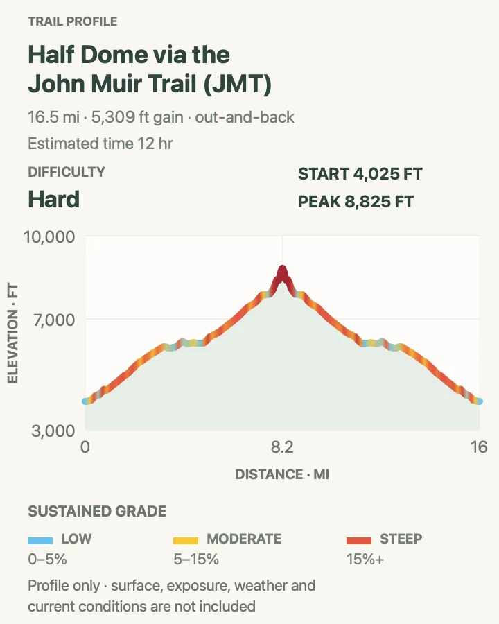
| Half Dome via the John Muir Trail | About 16.5 miles round trip on the reviewed track | 10 to 14 hours | Hard | A permit-controlled summit day with extreme distance, climbing, and exposure |
Lower Yosemite Fall Trail
- Distance
- About 1.2 miles around the reviewed loop
- Elevation gain
- 65 feet
- Time
- 30 minutes to 1 hour
- Difficulty
- Easy
- Route type
- Loop
- Parking
- Use an open Yosemite Valley day-use lot, then walk or take the free shuttle to the Lower Yosemite Fall trailhead near shuttle stop 6.
- Best time
- Spring or early summer for strong flow and spray; early morning for a quieter path.
- Pets
- Leashed pets are allowed on this paved loop but not on adjacent unpaved trails; pets cannot ride the shuttle.
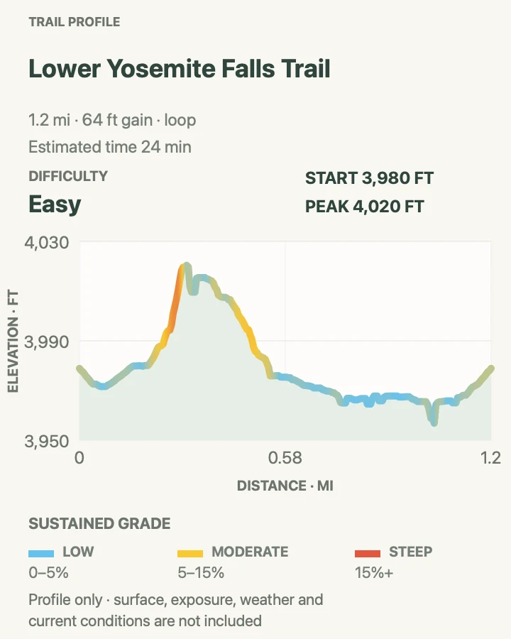
Lower Yosemite Fall is the low-commitment way to see the full waterfall system from the valley floor. The reviewed loop measures about 1.2 miles and gains only about 65 feet. Paving, exhibits, and frequent viewpoints make the outing approachable, but strong spring runoff can soak the footbridge and nearby pavement.
Walk the loop rather than stopping at the first open view. The east side is the accessible section identified by NPS, while current maintenance, snow, ice, or debris can still change conditions. Flow normally fades sharply by late summer and the falls may become dry, so a dry August visit is a different outing from a cold, misty May morning.
What helps on this route
- Carry a light shell in high water; spray can reach the bridge before rain appears in the forecast.
- Use the paved approach from the welcome-center area when the shuttle is crowded.
Terrain and access: Paved, gently graded loop with bridges, busy viewing areas, seasonal spray, and possible wet or icy surfaces.

Upper Yosemite Falls Trail
- Distance
- About 6.3 miles round trip on the reviewed track
- Elevation gain
- 3,280 feet
- Time
- 5.5 to 8 hours
- Difficulty
- Hard
- Route type
- Out and back
- Parking
- Park in an open valley lot and walk or shuttle toward Camp 4; begin at the signed Upper Yosemite Fall trailhead rather than the lower-fall loop.
- Best time
- A cool spring or early-summer morning with strong waterfall flow and no storm threat.
- Pets
- Pets are not permitted on this trail; trained service animals are allowed.
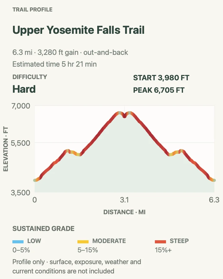
Upper Yosemite Falls climbs almost immediately from the Camp 4 area. Long switchbacks rise through forest to Columbia Rock, then the trail traverses into a view of the upper fall before another steep series reaches the north rim. The reviewed track measures about 6.3 miles and records roughly 3,280 feet of accumulated climbing.
The ascent is exposed to sun and can feel much hotter than the valley forecast suggests. The high point near the rim is also far enough above the start for wind, cold, or a storm to replace that heat. Bring all needed water, avoid switchback shortcuts, and keep the descent in the time budget; loose granite on tired legs is often the harder half of the day.
What helps on this route
- Reach Columbia Rock early enough to reassess heat, water, and pace before committing to the upper switchbacks.
- Save energy for the descent and carry a headlamp even when the planned return is before sunset.
Terrain and access: Relentless dirt-and-granite switchbacks, sunny traverses, loose decomposed granite, steep drops, and a high exposed rim.

Sentinel Dome and Taft Point Loop
- Distance
- About 5.2 miles around the reviewed loop
- Elevation gain
- 1,190 feet
- Time
- 2.5 to 4 hours
- Difficulty
- Moderate
- Route type
- Loop
- Parking
- Use the signed Sentinel Dome/Taft Point trailhead on Glacier Point Road; there is no regular shuttle from Yosemite Valley.
- Best time
- A clear morning after Glacier Point Road opens, before afternoon lightning or smoky haze develops.
- Pets
- Pets are not permitted on this trail; trained service animals are allowed.
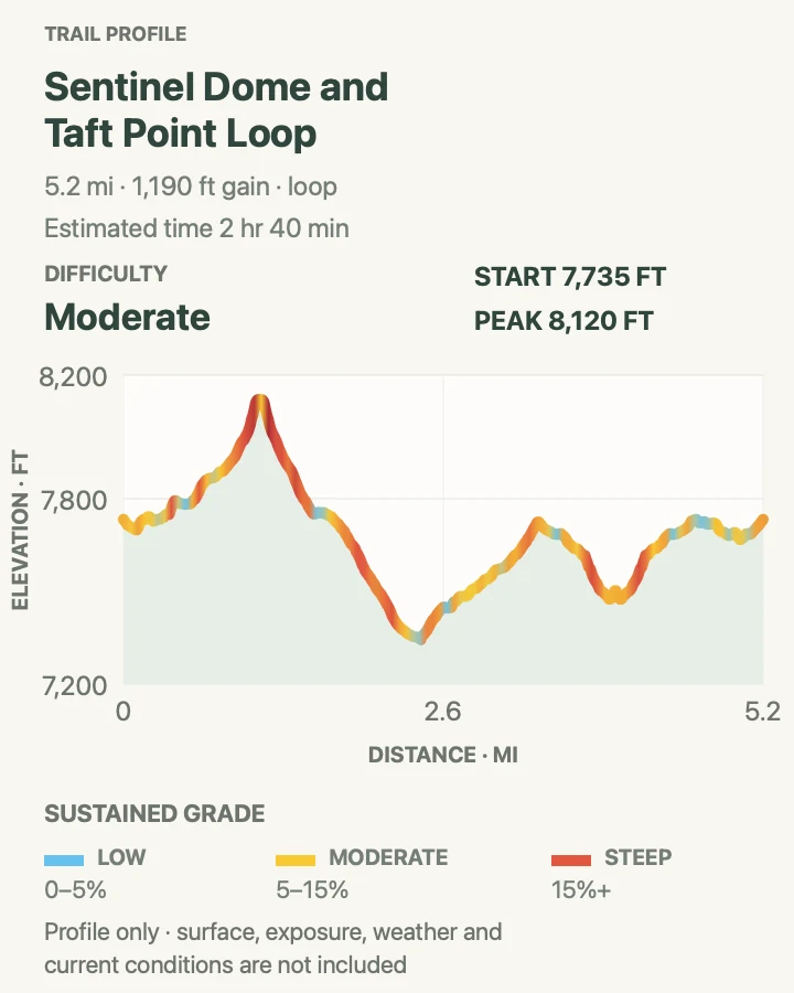
This circuit links two very different viewpoints from one trailhead. Sentinel Dome finishes on open granite with a broad view across Yosemite's high country. Taft Point faces the valley from a cliff edge cut by deep fissures. Connecting them through forest produces a 5.2-mile loop with about 1,190 feet of accumulated climbing on the reviewed profile.
The trailhead begins above 7,700 feet, so cool air does not remove altitude or thunderstorm risk. Sentinel Dome should be vacated at the first sign of lightning. At Taft Point, railings protect only limited spots; fissures and outer ledges remain exposed. Stay on durable tread, supervise children closely, and do not step backward for a photograph.
What helps on this route
- Download the map before driving Glacier Point Road, where service can be unreliable.
- Skip both exposed viewpoints when thunder is audible, even if the sky above the trailhead is still blue.
Terrain and access: High-elevation forest trail, granite slabs, short steep grades, exposed dome walking, open cliff edges, and deep rock fissures.

Mirror Lake Loop
- Distance
- About 5.1 miles around the reviewed loop
- Elevation gain
- 410 feet
- Time
- 2 to 3 hours
- Difficulty
- Easy
- Route type
- Loop
- Parking
- Parking is not available at Mirror Lake. Use a valley day-use lot and the free shuttle to stop 17, or approach on the paved multiuse path.
- Best time
- Winter through early summer when the lake holds water; morning for calm reflections and lighter traffic.
- Pets
- Leashed pets may use the paved road to the lake but are prohibited on the unpaved loop; pets cannot ride the shuttle.
Mirror Lake is a seasonal widening of Tenaya Creek rather than a deep year-round lake. The full loop continues beyond the paved approach, crosses the creek, and returns along the opposite side of Tenaya Canyon. The reviewed line measures about 5.1 miles with roughly 410 feet of accumulated gain, most of it spread across small rises.
Expect the water and reflections to change with the season. NPS notes that Mirror Lake is often dry in summer and fall. Rockfall is part of this canyon's natural setting, so obey closures and do not linger below fresh debris or leave the established route. The unpaved loop also removes the pet access that applies to the paved road.
What helps on this route
- Choose this for the canyon walk rather than relying on a full lake outside winter and spring.
- Check the bridge and rockfall status before committing to the full loop.
Terrain and access: Paved approach followed by natural trail, forest shade, creek crossings, sandy or rocky tread, small rolling grades, and rockfall terrain.

Vernal and Nevada Falls via Mist Trail
- Distance
- About 6.3 miles around the reviewed loop
- Elevation gain
- 2,210 feet
- Time
- 4.5 to 7 hours
- Difficulty
- Hard
- Route type
- Loop
- Parking
- Parking is not available at Happy Isles. Leave the vehicle in an open valley lot and use the free shuttle or walk to the Happy Isles trailhead.
- Best time
- A cool spring or early-summer start outside the active repair window, with traction for wet steps.
- Pets
- Pets are not permitted on this trail, including the paved lower approach; trained service animals are allowed.
The Happy Isles climb reaches the Vernal Fall footbridge before the Mist Trail and John Muir Trail divide. The selected circuit continues past Vernal Fall to Nevada Fall and uses the two trails as a loop. Its reviewed geometry measures about 6.3 miles with roughly 2,210 feet of accumulated gain. More than 600 steep granite steps, spray, heat, and crowded pinch points make the number feel larger.
During the 2026 weekday repair window, the usual Mist Trail segment above the footbridge is closed and the John Muir Trail is the signed alternate. Do not cross a barrier to preserve the mapped direction. Stay out of the river, remain behind railings at both falls, and carry enough water beyond the footbridge; the drinking fountain there is the only treated trail water identified by NPS.
What helps on this route
- Check the same-day Mist Trail schedule before choosing a direction around the loop.
- Carry a headlamp and give descending hikers room on wet stairs and narrow turns.
Terrain and access: Steep paved approach, granite stairways, waterfall spray, loose rock, long switchbacks, exposed viewpoints, and sustained climbing.

Half Dome via the John Muir Trail
- Distance
- About 16.5 miles round trip on the reviewed track
- Elevation gain
- 5,310 feet
- Time
- 10 to 14 hours
- Difficulty
- Hard
- Route type
- Out and back
- Parking
- Parking is not available at Happy Isles. Use an open Yosemite Valley lot and walk or shuttle to the trailhead; account for that connection in the day's mileage and time.
- Best time
- A dry, stable day while the cables are up, beginning well before sunrise with a valid permit.
- Pets
- Pets are not permitted on this trail; trained service animals are allowed, but the cable route presents severe practical hazards.
Half Dome shares the Happy Isles and Little Yosemite Valley approach with the waterfall corridor, then continues through forest to the subdome and cable route. That separate summit is why it remains in the guide despite substantial overlap below Nevada Fall. The reviewed track measures about 16.5 miles, climbs approximately 5,310 feet, and reaches roughly 8,825 feet.
A permit is required beyond the base of the subdome whenever the cables are up. The final granite is steep and fully exposed; gloves and cables do not make wet rock or lightning manageable. Turn around if storms build, the rock is wet, water or daylight is running short, or anyone in the group is too fatigued to descend the same corridor.
What helps on this route
- Carry the permit confirmation and the permit holder's identification; verify current cable status before leaving the valley.
- Pack a headlamp, enough water and food, sun protection, and layers for a summit much colder and windier than Happy Isles.
Terrain and access: Very long mountain route with paved and rocky trail, sustained switchbacks, stairways, high-elevation forest, steep subdome slabs, and exposed cables.

Official planning sources
Trail access and safety details were checked against these National Park Service pages. The maps and profiles follow the corresponding route geometry.
- NPS: Current Yosemite conditions and trail closures
- NPS: Yosemite Valley day-hike distances and difficulty
- NPS: Lower Yosemite Fall Trail
- NPS: Vernal Fall, Nevada Fall, and the 2026 Mist Trail detour
- NPS: Half Dome permits for day hikers
- NPS: 2026 permits and entrance reservations
- NPS: Glacier Point Road day hikes
- NPS: Trailhead access and parking
- NPS: Hiking safety and trail etiquette
- NPS: Current pet rules
- NPS: Bears and food storage
Map data © OpenStreetMap contributors. Trail geometry and planning details include National Park Service public information.