22 Best Hikes in Virgin Islands National Park
Twenty-two distinct St. John hikes, with custom terrain maps, measured elevation profiles, trailhead notes, heat and parking guidance, and live park conditions.
Hiking on St. John is a transportation problem before it is a mileage problem. Cruz Bay, the north-shore beaches, Centerline Road, Coral Bay, and the south-shore trailheads form separate clusters on narrow roads where parking is scarce. A taxi or a carefully timed drop-off often makes a better plan than circling a full pullout, and several routes begin far from reliable cell service.
These twenty-two routes move roughly from Cruz Bay around the north shore, through the central ridges, and then toward Lameshur and Salt Pond. The set includes short ruin and salt-pond walks, steep historic-road descents, exposed coastal headlands, and a few quieter connectors. Distances on the cards follow the route geometry used to generate each map and profile, so they may differ from rounded signs or from a longer combination described by NPS.
Official planning information was checked on August 30, 2026. Trail vegetation, storm damage, road access, surf, and heat can change faster than an article. Read the live alert and weather panels before leaving service, take a current park map, and let signs, barriers, and ranger directions override the mapped line.
Live park weather
Virgin Islands National Park
Representative park location, central St. John
Loading the latest conditions and alerts…
What changes a hiking day here
Solve the trailhead before choosing the hike
NPS says all beach and trailhead parking is limited and recommends arriving early, carpooling, or taking a taxi. Safari taxis serve many island locations, while the hourly public bus follows Centerline Road rather than every coastal spur. Confirm both the drop-off and pickup plan; a one-way descent to a quiet bay can end far from transportation.
Carry water for tropical heat, not just distance
The park's minimum recommendation is one-half gallon of water for each four hours of hiking. Exposed routes such as L'Esperance, Johnny Horn, Ram Head, Brown Bay, and the south-shore spurs can feel much harder than their mileage in direct sun. Start early, wear loose sun-protective clothing, carry snacks, and turn around before the return climb becomes a heat emergency.
Treat rain as a footing change
Many trails are rocky, steep, or both, and NPS warns that they become slippery in rain. Roots, stone steps, loose gravel, and wet leaves can remain slick after the shower passes. Reef Bay can be slippery even when dry. Use closed-toe shoes with traction and postpone exposed rock or a steep descent when storms are building.
Keep hurricane and surf plans flexible
Summer and fall can bring tropical waves, storms, or hurricanes, while winter fronts can create large breaking waves on north-shore beaches. A trail may be open while the water at its destination is unsafe. Check the live forecast and alerts, heed posted warnings, and do not make a swim or snorkel the condition for completing the hike.
Avoid plants instead of identifying them by touch
Christmas bush contains an irritant similar to poison ivy, manchineel is highly toxic, and low cacti can break off when brushed. Stay on the maintained tread, wear clothing that limits skin contact on brushy routes, and do not eat unknown fruit or handle vegetation. Insect repellent is especially useful during rainy periods.
Historic ruins are fragile terrain
Stone walls, plantation structures, and archeological sites appear beside many routes. NPS prohibits climbing, sitting, or standing on unstable historic walls and asks visitors not to touch the Reef Bay petroglyphs. View structures from established ground, leave artifacts where they are, and do not create shortcuts through cultural sites.
Know where leashed dogs must stop
Leashed dogs are allowed on park trails, and the leash may not exceed six feet, but pets are not allowed on designated beaches. On routes that end at Honeymoon, Reef, Leinster, Brown, Salt Pond, or another beach, the trail permission does not extend onto the sand. Never leave a pet tied or unattended, and carry out waste.
Download navigation before the drive
Many trails have limited or no cell service, and some intersections connect several old roads and spur trails. Save the mobile map, carry the current NPS map, tell someone the route and return time, and photograph temporary signs. Where a road walk is unavoidable, NPS advises facing traffic; vehicles drive on the left in the U.S. Virgin Islands.
| Trail | Distance | Time | Difficulty | Best for |
|---|---|---|---|---|
| Lind Point Trail to Honeymoon Beach | 2.1 miles around the loop | About 57 minutes | Easy | A car-light walk from Cruz Bay to the north shore |
| Caneel Hill Trail | 4.6 miles round trip | About 3 hours 30 minutes | Hard | A sustained ridge climb above Cruz Bay |
| Hawksnest Beach Shore Walk | 0.4 mile round trip | About 1 hour with a beach stop | Easy | A short shoreline leg-stretcher |
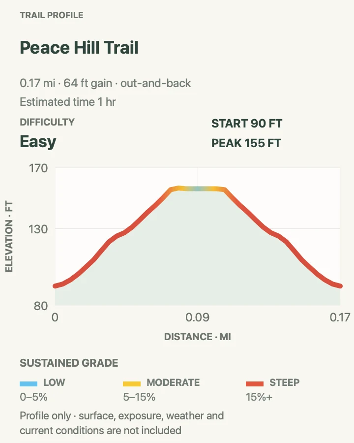
| Peace Hill Trail | 0.2 mile round trip | About 20 to 40 minutes | Easy | A short ruin and headland viewpoint |
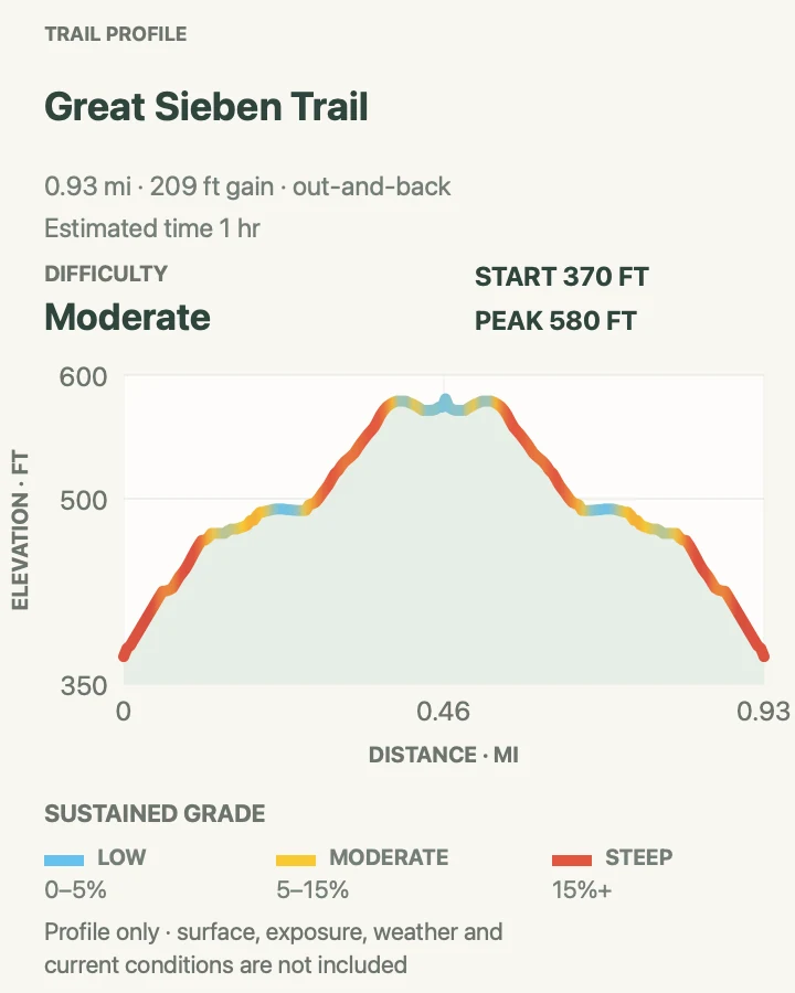
| Great Sieben Trail | 1 mile round trip | About 1 hour | Moderate | A quieter historic-road walk |
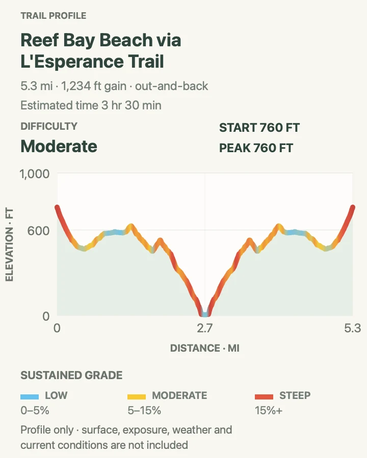
| Reef Bay Beach via L'Esperance Trail | 5.5 miles round trip | About 3 hours 30 minutes | Moderate | Historic plantation sites and a west-facing bay descent |
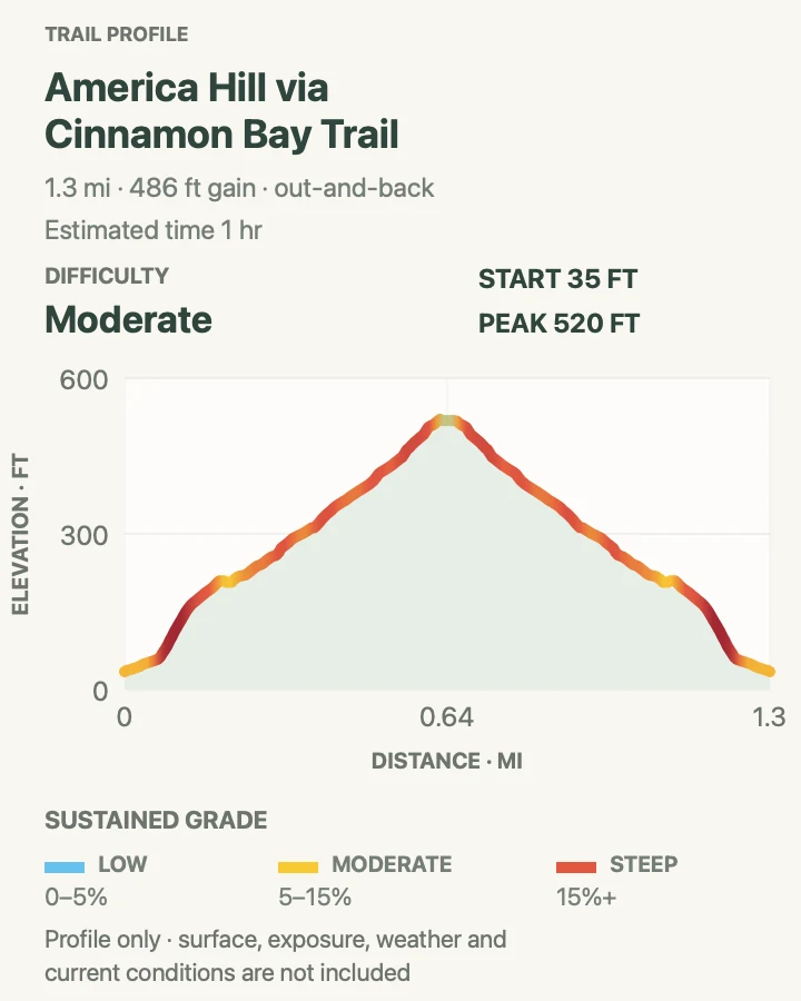
| America Hill via Cinnamon Bay Trail | 1.3 miles round trip | About 1 hour | Moderate | A compact climb from plantation ruins to a hilltop site |
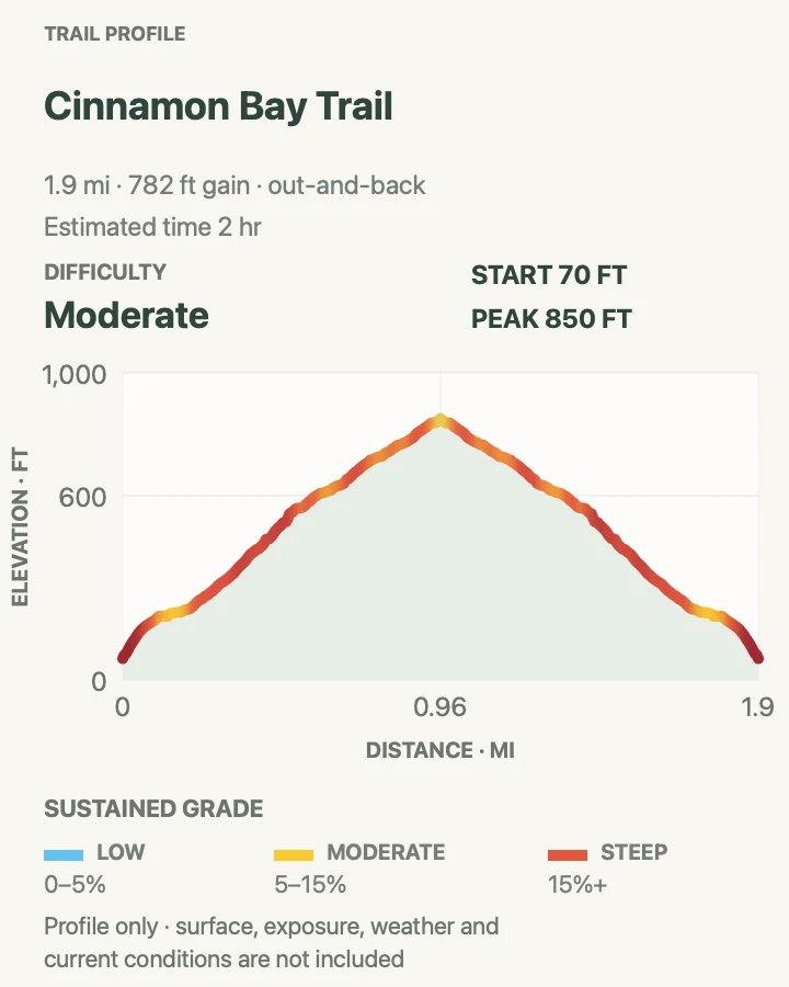
| Cinnamon Bay Trail | 2 miles round trip | About 2 hours | Moderate | A forest climb from North Shore Road toward Centerline Road |
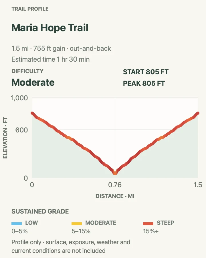
| Maria Hope Trail | 1.6 miles round trip | About 1 hour 30 minutes | Moderate | A less-traveled forest and historic-road route |
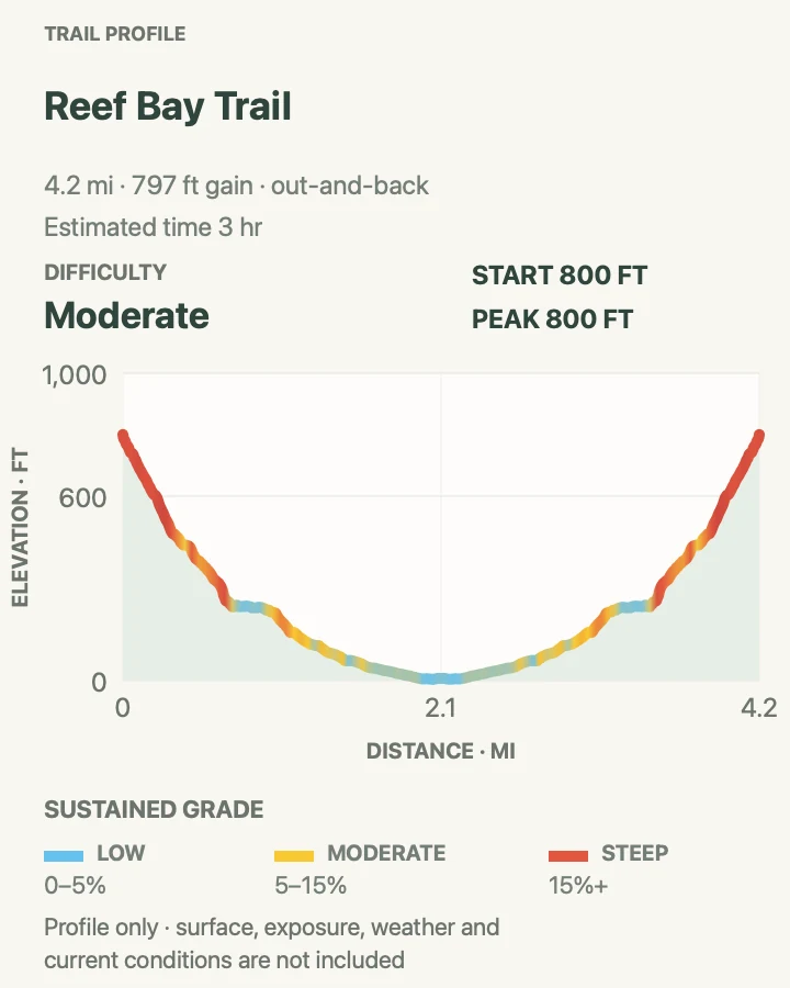
| Reef Bay Trail | 4.3 miles round trip | About 3 hours | Moderate | Tropical forest, plantation history, and the petroglyph side trail |
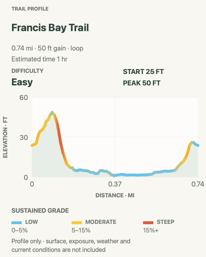
| Francis Bay Trail | 0.7 mile around the loop | About 30 to 90 minutes | Easy | Birding and an accessible salt-pond boardwalk |
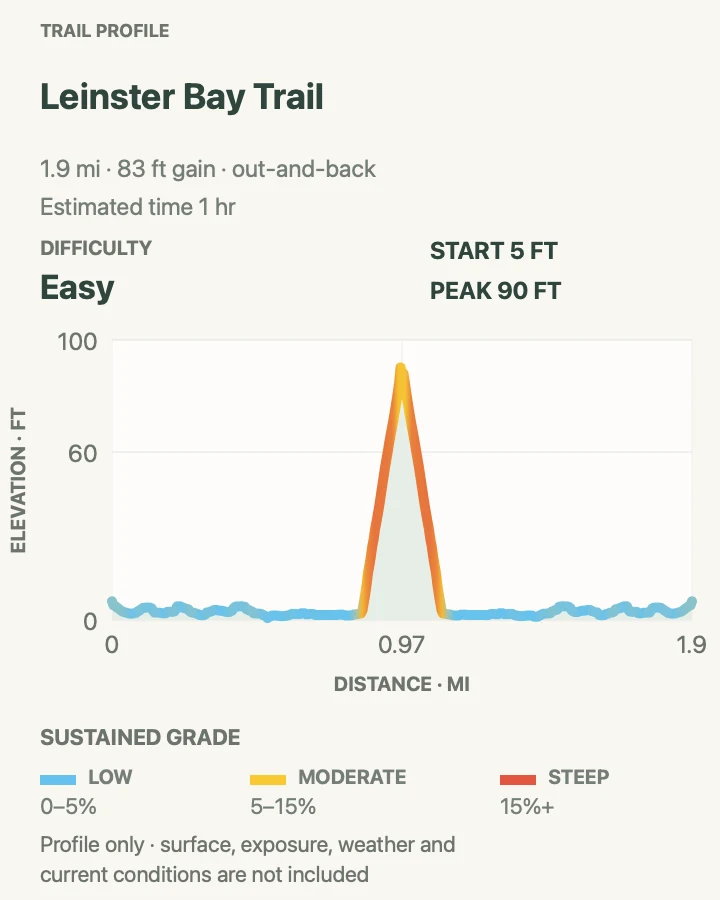
| Leinster Bay Trail | 2 miles round trip | About 1 hour | Easy | A mostly gentle coastal walk toward Waterlemon Bay |
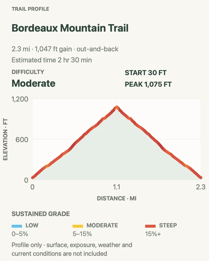
| Bordeaux Mountain Trail | 2.4 miles round trip | About 2 hours 30 minutes | Moderate | A high interior ridge walk away from beach traffic |
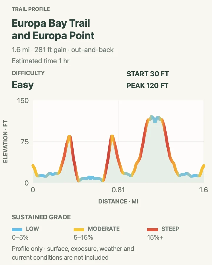
| Europa Bay Trail and Europa Point | 1.6 miles round trip | About 1 hour | Easy | A quiet south-shore bay and point |
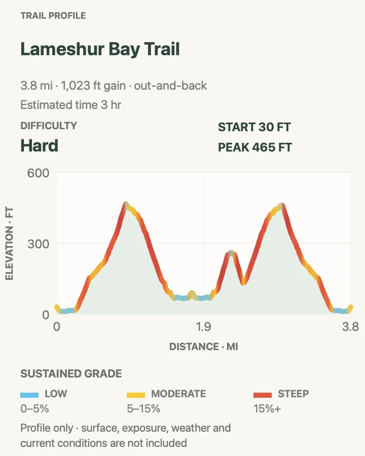
| Lameshur Bay Trail | 4 miles round trip | About 3 hours | Hard | A longer south-shore backcountry corridor |
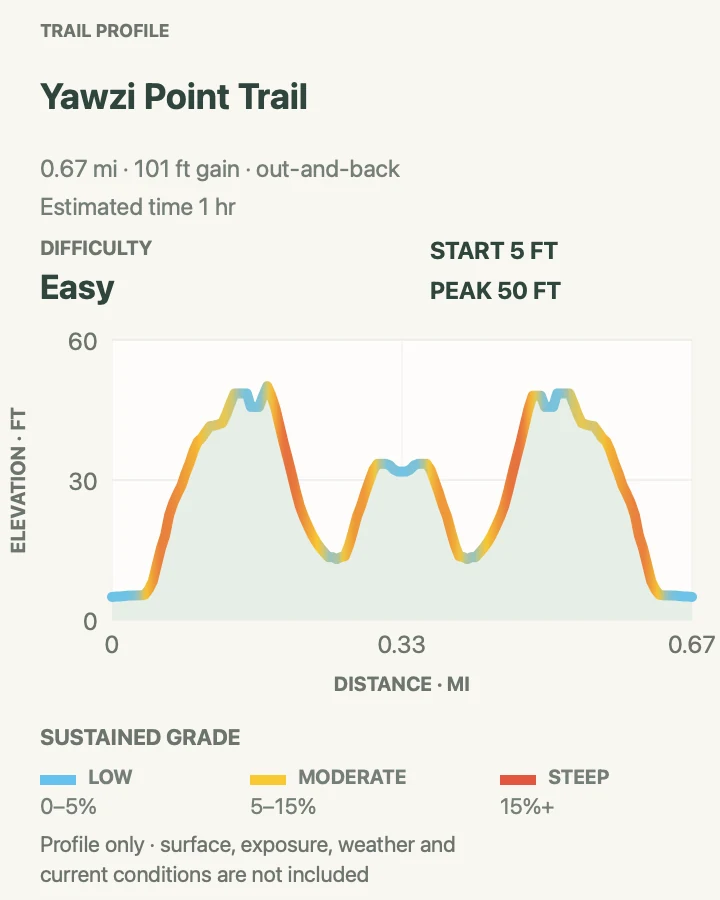
| Yawzi Point Trail | 0.7 mile round trip | About 1 hour | Easy | A short rocky point between the Lameshur bays |
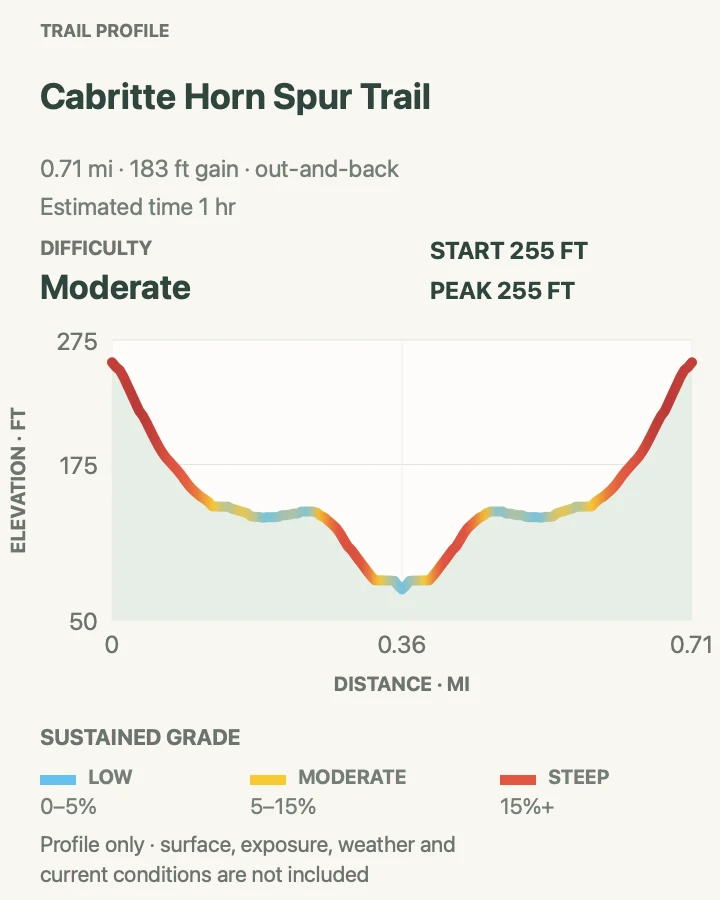
| Cabritte Horn Spur Trail | 0.7 mile round trip | About 1 hour | Moderate | A little-used cliff-top spur |
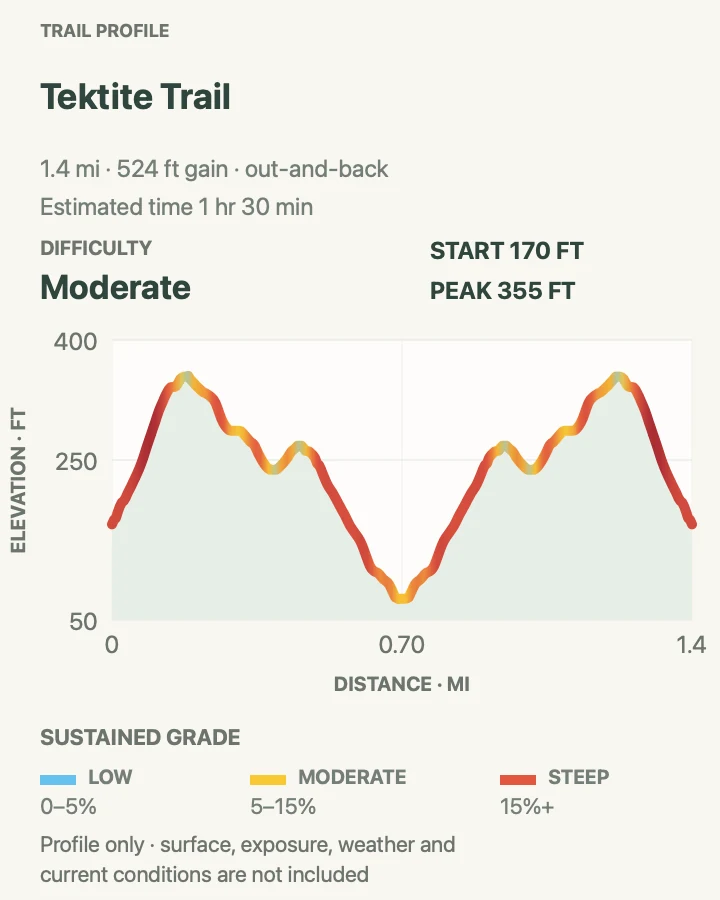
| Tektite Trail | 1.4 miles round trip | About 1 hour 30 minutes | Moderate | South-shore geology and a quieter coastal landscape |
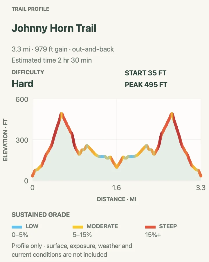
| Johnny Horn Trail | 3.3 miles round trip | About 2 hours 30 minutes | Hard | A steep ridge, historic sites, and Coral Bay views |
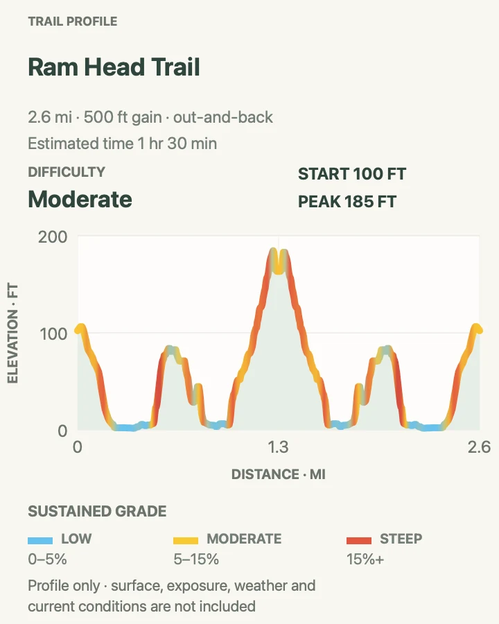
| Ram Head Trail | 2.7 miles round trip | About 1 hour 30 minutes | Moderate | An exposed headland above the Caribbean Sea |
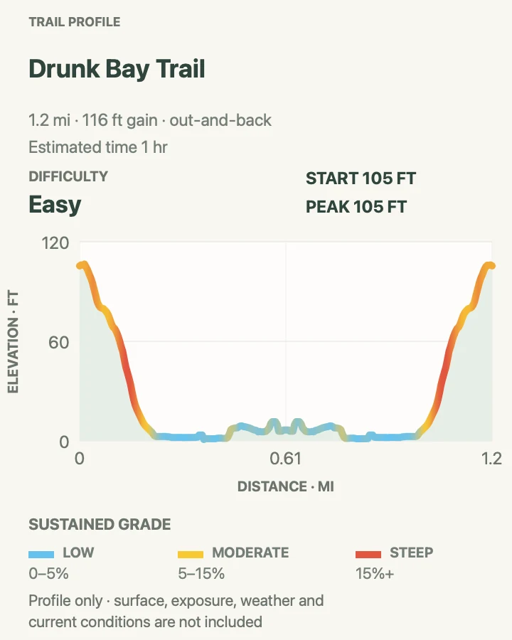
| Drunk Bay Trail | 1.2 miles round trip | About 1 hour | Easy | A salt pond and wild east-facing shore |
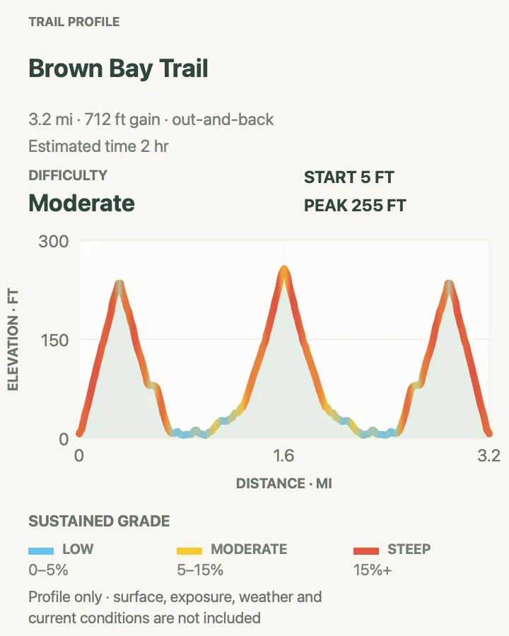
| Brown Bay Trail | 3.2 miles round trip | About 2 hours | Moderate | A quieter bay reached over a dry ridge |
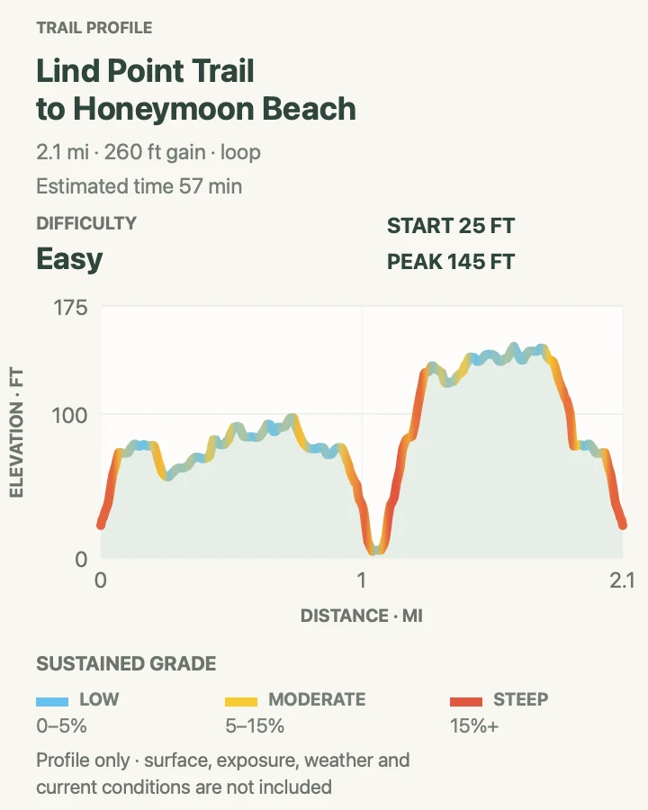
Lind Point Trail to Honeymoon Beach
- Distance
- 2.1 miles around the loop
- Elevation gain
- 260 feet
- Time
- About 57 minutes
- Difficulty
- Easy
- Route type
- Loop
- Parking
- Start behind the Cruz Bay Visitor Center. Drivers must obtain the NPS parking permit before using a designated visitor-center space.
- Best time
- Morning, before beach heat and visitor-center parking demand build.
- Pets
- Leashed dogs are allowed on the trail but not on Honeymoon Beach.
Lind Point turns a Cruz Bay arrival into a real hike without an island drive. Signed upper and lower branches cross rocky coastal forest, meet viewpoints above Pillsbury Sound, and connect with Salomon and Honeymoon bays. This mapped loop uses the Honeymoon connection and returns through the same trail system rather than treating each spur as a separate hike.
The network is well signed, but the beach destinations can make the route feel busier than its wooded sections. Note each junction on the outbound walk, keep the return climb in reserve, and remember that a visitor-center parking space requires the park permit.
What helps on this route
- Collect a current map and parking permit at the visitor center before climbing the stairs to the trail.
- Carry water for the return; shade does not remove the heat and humidity.
Terrain and access: Narrow rocky forest trail with signed spurs, rolling grades, roots, and warm coastal exposure.

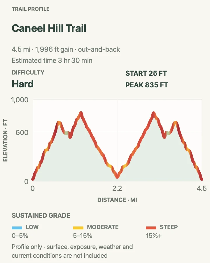
Caneel Hill Trail
- Distance
- 4.6 miles round trip
- Elevation gain
- 2,000 feet
- Time
- About 3 hours 30 minutes
- Difficulty
- Hard
- Route type
- Out and back
- Parking
- Use the small designated area near the Caneel Hill trailhead above Cruz Bay, or approach through the Upper Lind Point Trail and Caneel Spur.
- Best time
- Early morning in dry weather, before the exposed climb becomes hot.
- Pets
- Leashed dogs are allowed; use a leash no longer than six feet.
The full mapped Caneel Hill outing extends beyond the one-mile NPS climb to the observation deck and follows the ridge before retracing its approach. The first ascent is steep and rocky, gaining the north-shore view quickly; continuing makes this a much larger commitment than the short summit option described on park signs.
Rain turns the uneven rock and soil slick, and the ridge has little margin for a late heat start. Decide at the platform whether the group has enough water and time for the longer line, then return by the same junctions rather than drifting onto a Lind Point connector.
What helps on this route
- Treat the observation deck as a turnaround gate if the heat, footing, or water supply is already marginal.
- Confirm the exact return branch at every junction; several nearby trails point toward Cruz Bay.
Terrain and access: Steep, very rocky ridge trail with uneven footing, exposed viewpoints, and slippery surfaces after rain.

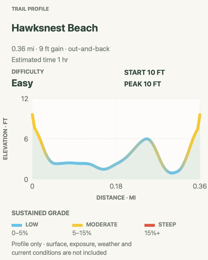
Hawksnest Beach Shore Walk
- Distance
- 0.4 mile round trip
- Elevation gain
- 10 feet
- Time
- About 1 hour with a beach stop
- Difficulty
- Easy
- Route type
- Out and back
- Parking
- Use only the marked Hawksnest Beach parking area on North Shore Road; continue elsewhere when spaces are full.
- Best time
- Early morning, before the small lot and beach fill.
- Pets
- Pets are not allowed on the beach; choose a non-beach trail when hiking with a dog.
This short route follows the established access and edge of Hawksnest rather than pretending the beach stop is a backcountry hike. It earns a place as a distinct, low-effort walk between steeper north-shore trails, with the mapped distance covering the actual pedestrian line instead of only the few steps from the car.
Parking and surf are the deciding conditions. Do not create a shoulder space on the narrow road, and keep out of the water when winter swell, a posted warning, or a ranger indicates hazardous conditions.
What helps on this route
- Arrive early or use a taxi; the designated spaces are limited.
- Keep valuables with you rather than leaving them visible in a vehicle.
Terrain and access: Short beach-access path and sandy shoreline with sun, surf, and very little elevation change.

Peace Hill Trail
- Distance
- 0.2 mile round trip
- Elevation gain
- 65 feet
- Time
- About 20 to 40 minutes
- Difficulty
- Easy
- Route type
- Out and back
- Parking
- Use the signed Peace Hill parking area beside North Shore Road, east of Hawksnest, without blocking the road.
- Best time
- Morning or late afternoon when the exposed hilltop is cooler.
- Pets
- Leashed dogs are allowed on the trail; use a leash no longer than six feet.
Peace Hill climbs a short maintained track to a windmill ruin and an open north-shore headland. The walk is brief enough to pair with another North Shore Road stop, but the ruin is an archeological structure rather than playground equipment. Stay on established ground and keep off its walls.
Because the top is exposed, a small weather change is easy to feel. Wind, strong sun, or a building squall can matter more here than the distance suggests.
What helps on this route
- Leave the car elsewhere if every marked space is occupied; the road has no safe overflow shoulder.
- Do not climb or sit on the windmill walls.
Terrain and access: Short uphill dirt track to an exposed grassy headland and unstable historic stonework.

Great Sieben Trail
- Distance
- 1 mile round trip
- Elevation gain
- 210 feet
- Time
- About 1 hour
- Difficulty
- Moderate
- Route type
- Out and back
- Parking
- Use a legal designated pullout serving the signed trail and keep private driveways and the narrow road clear.
- Best time
- A dry morning, when the old-road surface and vegetation are easiest to read.
- Pets
- Leashed dogs are allowed; use a leash no longer than six feet.
Great Sieben follows a short remnant of the island's historic road network through tropical vegetation and cultural remains. It is quieter and less self-explanatory than the major signed attraction trails, which makes disciplined navigation more important than speed.
Keep to the maintained corridor and do not cross a private-property boundary to investigate a ruin or shortcut. Thick regrowth can obscure the road edge after a wet period, while stone and leaf litter become slick.
What helps on this route
- Download the map before the drive and turn around where the mapped line ends.
- Wear long clothing if recent growth has narrowed the corridor, and avoid brushing unidentified plants.
Terrain and access: Uneven historic road trace with stone, leaf litter, tropical vegetation, and limited wayfinding context.

Reef Bay Beach via L'Esperance Trail
- Distance
- 5.5 miles round trip
- Elevation gain
- 1,230 feet
- Time
- About 3 hours 30 minutes
- Difficulty
- Moderate
- Route type
- Out and back
- Parking
- Begin at the signed L'Esperance trailhead on Centerline Road and use only a legal designated pullout or arranged taxi drop-off.
- Best time
- Early morning, with enough time and water for the hot uphill return.
- Pets
- Leashed dogs are allowed on the trail but not on Reef Bay Beach.
L'Esperance follows a historic Danish road past plantation remains and the island's baobab before descending toward Reef Bay. Much of the corridor faces west and lacks shade. The geometry here goes to the beach and returns the same way, keeping it distinct from the separate Reef Bay Trail approach.
The downhill half can hide the cost of the return. Rocky tread is steep in places and may be slippery even when dry, so carry the full water supply from Centerline Road and turn back early if sun or footing is already slowing the descent.
What helps on this route
- Start with at least the park's minimum water recommendation and add capacity for direct sun.
- Do not climb on historic walls or detour across private land.
Terrain and access: Hot, rocky historic road with long descent and return climb, exposed west-facing sections, and ruins.

America Hill via Cinnamon Bay Trail
- Distance
- 1.3 miles round trip
- Elevation gain
- 490 feet
- Time
- About 1 hour
- Difficulty
- Moderate
- Route type
- Out and back
- Parking
- Use the Cinnamon Bay Beach parking area, cross North Shore Road carefully, and begin by the plantation ruins.
- Best time
- Morning, before heat gathers on the uphill spur.
- Pets
- Leashed dogs are allowed on the trail but not on Cinnamon Bay Beach.
America Hill uses the lower Cinnamon Bay Trail and its signed spur to reach great-house ruins above the north shore. The combination is shorter than following Cinnamon Bay Trail all the way to Centerline Road, and its distinct destination justifies keeping it beside that longer route.
The shaded forest does not make the climb flat. Roots, rock, and damp soil can be slippery, while the ruin itself must be viewed without climbing or leaning on its walls. Retrace the spur to the main trail and descend to the plantation area.
What helps on this route
- Cross North Shore Road only with a clear view in both directions; traffic drives on the left.
- Stay outside the great-house walls and avoid informal paths around the site.
Terrain and access: Shaded but rocky uphill trail with roots, a signed spur, and fragile hilltop ruins.

Cinnamon Bay Trail
- Distance
- 2 miles round trip
- Elevation gain
- 780 feet
- Time
- About 2 hours
- Difficulty
- Moderate
- Route type
- Out and back
- Parking
- Use the Cinnamon Bay Beach lot, cross North Shore Road carefully, and start east of the plantation ruins.
- Best time
- A cool morning, leaving the shorter ruin loop for hotter hours.
- Pets
- Leashed dogs are allowed on the trail but not on Cinnamon Bay Beach.
Cinnamon Bay Trail climbs through moist forest from the plantation area toward Centerline Road. NPS distinguishes it from the easy half-mile nature loop: this is the steeper one-mile trail, passing large tropical trees and the America Hill spur before reaching the upper road.
Turn around at the mapped upper endpoint rather than walking the narrow road to invent a loop. Wet roots and rock complicate the descent, and intermittent shade can disguise how warm the sustained climb has become.
What helps on this route
- Do not confuse the accessible nature loop with the uphill Cinnamon Bay Trail when setting group expectations.
- Photograph the America Hill junction on the ascent so the direct return remains obvious.
Terrain and access: Sustained forest climb on uneven rock, soil, and roots, with damp slippery sections after rain.

Maria Hope Trail
- Distance
- 1.6 miles round trip
- Elevation gain
- 750 feet
- Time
- About 1 hour 30 minutes
- Difficulty
- Moderate
- Route type
- Out and back
- Parking
- Use a legal designated pullout at the signed trail access and avoid blocking Centerline Road or private entrances.
- Best time
- A dry morning when shaded rock and leaf litter are firm.
- Pets
- Leashed dogs are allowed; use a leash no longer than six feet.
Maria Hope uses an old island road through greener interior forest and historic remains. It receives less traffic than the neighboring Reef Bay corridor, so it is useful for hikers comfortable following a quieter mapped line without frequent reassurance from other visitors.
Stay on the signed corridor and treat walls, foundations, and artifacts as protected evidence rather than obstacles to cross. Rain can cover rock with slick leaves and bring fast vegetation growth into the edge of the trail.
What helps on this route
- Carry offline navigation and do not follow an unmarked opening beyond the route endpoint.
- Check for ticks or plant contact after brushy sections instead of handling vegetation on the trail.
Terrain and access: Uneven old-road tread through tropical forest, with stone, roots, leaf litter, and cultural remains.

Reef Bay Trail
- Distance
- 4.3 miles round trip
- Elevation gain
- 800 feet
- Time
- About 3 hours
- Difficulty
- Moderate
- Route type
- Out and back
- Parking
- Start at the signed Reef Bay trailhead near mile marker 5 on Centerline Road; use the designated area or a confirmed taxi pickup.
- Best time
- Early morning, with a cool ascent window and extra time for the interpretive sites.
- Pets
- Leashed dogs are allowed on the trail but not on Reef Bay Beach.
Reef Bay descends through moist forest past stone walls and the remains of several sugar estates. A signed side trail leads to the petroglyph pool, and the main corridor continues toward the sugar works and bay. The mapped line used here is shorter than the full approximately six-mile trailhead-to-beach round trip described by NPS, so follow the card and map instead of assuming every published distance represents the same turnaround.
NPS calls the backcountry trail steep, uneven, rocky, and slippery even when dry. The outward descent saves the harder work for the return to Centerline Road. Do not touch the petroglyphs, climb on ruins, or depend on an unconfirmed boat pickup.
What helps on this route
- Budget the water and time around the uphill return, not the easier first mile.
- If joining a seasonal guided hike, use its stated shuttle and boat plan; do not assume those services exist independently.
Terrain and access: Steep rocky forest descent and return climb, with slippery stone, ruins, and a signed petroglyph spur.

Francis Bay Trail
- Distance
- 0.7 mile around the loop
- Elevation gain
- 50 feet
- Time
- About 30 to 90 minutes
- Difficulty
- Easy
- Route type
- Loop
- Parking
- Use the Francis Bay Sugar Factory area for the full loop; the beach-side lot provides easier access to the boardwalk section.
- Best time
- Early morning, especially from November through April for migratory birds.
- Pets
- Leashed dogs are allowed on the trail but not on Francis Bay Beach.
Francis Bay circles dry forest and a salt pond from the sugar-factory site. Its lower boardwalk reaches mangroves and bird-viewing platforms and was designed for wheelchair and stroller access; the rest of the loop is uneven and rocky, with a climb between the factory and beach ends.
Moving slowly is the point here. The park identifies this as its most productive birding trail, and the salt pond rewards quiet stops more than a fast lap. Use the beach-side parking when accessible boardwalk access is the priority.
What helps on this route
- Bring binoculars and keep voices low near the viewing platforms.
- Choose the beach-side approach for the gentler accessible segment; the whole loop is not wheelchair accessible.
Terrain and access: Accessible wooden boardwalk at the lower end, plus uneven rocky trail and a modest hill around the salt pond.

Leinster Bay Trail
- Distance
- 2 miles round trip
- Elevation gain
- 85 feet
- Time
- About 1 hour
- Difficulty
- Easy
- Route type
- Out and back
- Parking
- Use the designated Annaberg-area parking near the west end of Leinster Bay and keep the historic-site access clear.
- Best time
- Morning, before the exposed shoreline becomes hot and parking demand rises.
- Pets
- Leashed dogs are allowed on the trail but not on the beach.
Leinster Bay follows the north shoreline from the Annaberg side toward Waterlemon Bay and the start of Johnny Horn. The walking is gentler than the ridge routes, with views across the channel and access to a narrow beach, but sun and heat remain significant on the open coast.
This guide treats the shoreline walk as its own route and Johnny Horn as the separate steep continuation. Turn around at the mapped endpoint unless the group deliberately planned, watered, and transported for that larger outing.
What helps on this route
- Do not leave valuables in the vehicle or unattended on the shore.
- Avoid standing on coral or seagrass if the walk is paired with swimming.
Terrain and access: Mostly gentle, rocky coastal trail with direct sun, narrow beach access, and little reliable shade.

Bordeaux Mountain Trail
- Distance
- 2.4 miles round trip
- Elevation gain
- 1,050 feet
- Time
- About 2 hours 30 minutes
- Difficulty
- Moderate
- Route type
- Out and back
- Parking
- Use a legal designated space at the signed Bordeaux Mountain trail access and keep Centerline Road clear.
- Best time
- A dry, cool morning before cloud or heat settles over the ridge.
- Pets
- Leashed dogs are allowed; use a leash no longer than six feet.
Bordeaux Mountain explores the park's high interior rather than descending directly to a beach. The route passes through forest on an uneven ridge corridor, offering a different scale from the short north-shore and salt-pond walks.
Cloud, rain, and fast-growing vegetation can reduce both traction and route clarity. Carry the offline map and return on the same line without turning an unsigned road or property edge into a loop.
What helps on this route
- Confirm the trailhead in daylight; the road and nearby driveways are not overflow parking.
- Turn around if storm cloud removes visibility or makes the ridge rock slick.
Terrain and access: Forested high-ridge path with uneven stone, roots, humid shade, and occasional exposed sections.

Europa Bay Trail and Europa Point
- Distance
- 1.6 miles round trip
- Elevation gain
- 280 feet
- Time
- About 1 hour
- Difficulty
- Easy
- Route type
- Out and back
- Parking
- Use designated parking at the Lameshur access area after confirming the unpaved approach is suitable for the vehicle.
- Best time
- Early morning in settled weather, before south-shore heat builds.
- Pets
- Leashed dogs are allowed on the trail but not on the beach.
Europa Bay and its point form a quiet south-shore outing from the Lameshur network. The route stays outside the White Cliffs closure and uses the established trail rather than the prohibited landward shoreline between Europa and Reef bays.
The walk is modest in distance but remote in feel. Bring navigation, water, and a vehicle plan for the rough Lameshur access road; NPS recommends four-wheel drive and notes that some rental agreements prohibit that road.
What helps on this route
- Check the current compendium and trail signs so the White Cliffs closure remains outside the route.
- Confirm that the rental agreement permits the Lameshur road before driving it.
Terrain and access: Remote coastal trail with rock, scrub, direct sun, and a rough unpaved road approach.

Lameshur Bay Trail
- Distance
- 4 miles round trip
- Elevation gain
- 1,020 feet
- Time
- About 3 hours
- Difficulty
- Hard
- Route type
- Out and back
- Parking
- Use designated Little Lameshur parking after confirming the rough access road and vehicle rules.
- Best time
- Early morning, allowing a cool return and enough daylight for the road out.
- Pets
- Leashed dogs are allowed on the trail but not on beaches along the route.
Lameshur Bay Trail leaves the developed bay area for a longer backcountry traverse through the park's south side. It connects with a broader historic trail network, so the mapped turnaround matters: adding every junction can create a much longer day and enter other route families in this guide.
Remote tread, heat, and transportation make this more demanding than the mileage alone. The White Cliffs land closure lies south of the trail corridor; stay on the designated trail and never use an unofficial shoreline shortcut toward Europa or Reef Bay.
What helps on this route
- Carry enough water for delays and download the map before leaving Coral Bay service.
- Leave time to drive the rough road in daylight and turn back before an unplanned network junction.
Terrain and access: Rocky remote backcountry trail with sustained grades, tropical vegetation, heat, and limited cell service.

Yawzi Point Trail
- Distance
- 0.7 mile round trip
- Elevation gain
- 100 feet
- Time
- About 1 hour
- Difficulty
- Easy
- Route type
- Out and back
- Parking
- Use designated parking at Great or Little Lameshur and follow the signed connector toward Yawzi Point.
- Best time
- A calm early morning before heat and afternoon squalls.
- Pets
- Leashed dogs are allowed on the trail but not on the beaches.
Yawzi Point follows the narrow land between Great and Little Lameshur bays. The route is short, but rock and coastal exposure make it more than a flat beach stroll. Stay on the established line to protect dry-forest and shoreline vegetation.
Access still depends on the rough Lameshur road. NPS recommends four-wheel drive and tells renters to check the vehicle contract. A calm bay does not guarantee calm conditions on the point, so turn around when wind or rain arrives.
What helps on this route
- Wear shoes suitable for sharp rock instead of relying on beach sandals.
- Keep clear of cliff edges and return before a squall reaches the point.
Terrain and access: Short rocky coastal spur through dry scrub, with exposed shoreline and uneven footing.

Cabritte Horn Spur Trail
- Distance
- 0.7 mile round trip
- Elevation gain
- 180 feet
- Time
- About 1 hour
- Difficulty
- Moderate
- Route type
- Out and back
- Parking
- Use a legal designated area along Lameshur Road near the signed spur; do not block the narrow road.
- Best time
- Early morning in dry, calm weather.
- Pets
- Leashed dogs are allowed; keep them controlled near rock and cactus.
Cabritte Horn is a short south-shore spur with a larger sense of exposure than its distance suggests. The mapped route climbs from the Lameshur Road corridor toward the coastal cliffs, through dry vegetation where cactus and loose rock demand attention.
This is not a place to extend the hike onto an informal cliff path. Follow the mapped turnaround, keep away from drop-offs, and avoid the route when wet rock or strong wind compromises footing.
What helps on this route
- Wear long clothing and closed-toe shoes for cactus and brush.
- Turn around at the mapped endpoint rather than exploring beyond the established trail.
Terrain and access: Dry, rocky spur with cactus, loose footing, coastal wind, and unguarded cliff exposure.

Tektite Trail
- Distance
- 1.4 miles round trip
- Elevation gain
- 520 feet
- Time
- About 1 hour 30 minutes
- Difficulty
- Moderate
- Route type
- Out and back
- Parking
- Use designated Lameshur-area parking and follow current signs near the Virgin Islands Environmental Resource Station.
- Best time
- A dry morning with stable weather and enough daylight for the rough road return.
- Pets
- Leashed dogs are allowed; use a leash no longer than six feet.
Tektite crosses the dry south-shore landscape near the environmental research station and reaches rugged coastal rock. It is one of the less-frequented trails maintained by the park's Friends group, so current signage and a downloaded route deserve more trust than a faint side track.
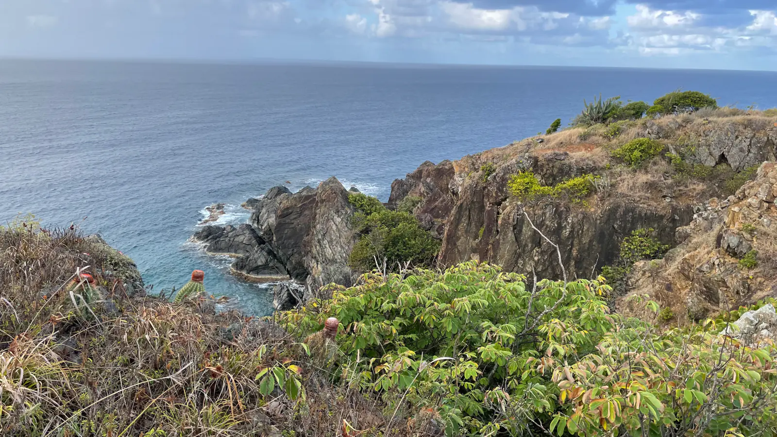
The terrain pictured in the guide's hero is representative: broken volcanic rock, dry scrub, cactus, and open ocean exposure. Keep the route on established tread, protect research and cultural sites, and turn back before rain reaches the rock.
What helps on this route
- Do not enter research facilities or follow service paths that are not part of the signed route.
- Carry sun protection and enough water for a slower rocky return.
Terrain and access: Rugged volcanic rock and dry coastal scrub, with cactus, sun, and limited route traffic.

Johnny Horn Trail
- Distance
- 3.3 miles round trip
- Elevation gain
- 980 feet
- Time
- About 2 hours 30 minutes
- Difficulty
- Hard
- Route type
- Out and back
- Parking
- Begin from the Leinster Bay/Annaberg side and walk the bay trail to Johnny Horn's signed start; arrange transportation for any one-way variation.
- Best time
- Early morning or late afternoon, avoiding the hottest exposed hours.
- Pets
- Leashed dogs are allowed on the trail but not on the beach approach.
Johnny Horn begins beyond Waterlemon Bay and climbs steeply past historic sites. A side trail reaches a hilltop view, while the main corridor continues past the Brown Bay junction toward Base Hill and Coral Bay. The route mapped here returns before turning that through-trail into a transportation problem.
NPS describes the trail as strenuous, steep, rocky, and exposed to sun. Carry water from the start of the Leinster approach, record the Brown Bay junction, and do not assume a taxi will be waiting at the far road without a confirmed arrangement.
What helps on this route
- Include the Leinster Bay approach in the day's heat and water calculation.
- Photograph the Brown Bay junction before continuing so the return line is unambiguous.
Terrain and access: Steep, rocky, sun-exposed ridge trail with historic sites, junctions, and a coastal approach.

Ram Head Trail
- Distance
- 2.7 miles round trip
- Elevation gain
- 500 feet
- Time
- About 1 hour 30 minutes
- Difficulty
- Moderate
- Route type
- Out and back
- Parking
- Use the small designated Salt Pond Bay trailhead area at the end of Route 107 and leave the road clear.
- Best time
- Sunrise or early morning; carry a light for any dawn start and avoid midday heat.
- Pets
- Leashed dogs are allowed on the trail but not on Salt Pond Bay or Blue Cobblestone Beach.
Ram Head starts with the old-road descent to Salt Pond Bay, crosses the far end of the beach, and climbs a narrow rocky trail toward the headland. Blue Cobblestone Beach breaks the ascent before the final exposed slope. Wide sea views arrive with very little shade.
The same exposure that makes the route memorable also makes heat, lightning, and wind serious. Carry all water, keep away from the cliff edge, and do not depend on a swim to cool the return when surf or posted conditions are unsafe.
What helps on this route
- Start before direct sun reaches the upper headland and carry a light if leaving at dawn.
- Save water for the final climb from Salt Pond Bay back to the parking area.
Terrain and access: Old road to beach, then narrow rocky coastal trail with steep grades, cactus, sun, and cliff exposure.

Drunk Bay Trail
- Distance
- 1.2 miles round trip
- Elevation gain
- 120 feet
- Time
- About 1 hour
- Difficulty
- Easy
- Route type
- Out and back
- Parking
- Use the designated Salt Pond Bay trailhead parking at the end of Route 107.
- Best time
- Morning, before the salt-pond edge and rocky coast become hot.
- Pets
- Leashed dogs are allowed on the trail but not on the beaches.
Drunk Bay branches from the Salt Pond area, skirts the pond, and reaches a rougher Atlantic-facing shore. It is shorter and less steep than Ram Head, but the destination is rocky rather than a protected swimming beach. Loose coral and stone sculptures should be left where natural processes placed them.
Winter fronts and trade winds can drive large waves onto this exposed side. Stay well back from wet rock, and turn around if water is crossing the shore route or wind makes the pond edge uncomfortable.
What helps on this route
- Do not enter rough water at Drunk Bay; use the hike as a shore viewpoint.
- Leave rocks, shells, coral fragments, and visitor arrangements in place.
Terrain and access: Mostly gentle salt-pond path followed by loose rock and an exposed, wave-washed shore.

Brown Bay Trail
- Distance
- 3.2 miles round trip
- Elevation gain
- 710 feet
- Time
- About 2 hours
- Difficulty
- Moderate
- Route type
- Out and back
- Parking
- Use a legal designated pullout at the signed Brown Bay trail access on East End Road and keep driveways and travel lanes clear.
- Best time
- Early morning, before heat settles on the dry exposed climb.
- Pets
- Leashed dogs are allowed on the trail but not on Brown Bay Beach.
Brown Bay crosses dry shrubland from East End Road to a remote north-facing bay. The route's quieter setting comes with a real climb, cactus, limited shade, and less immediate help than the busiest north-shore trails. A longer approach also connects from the Johnny Horn network, but that overlapping version is not duplicated here.
Follow the established line and stop at the beach boundary when hiking with a dog. The bay's shallow water does not make every condition safe; heed surf and weather warnings, and preserve enough water for the climb back to East End Road.
What helps on this route
- Wear closed-toe shoes and avoid brushing cactus or unidentified plants on the narrow tread.
- Mark the road-side trailhead offline so the return does not continue into the Johnny Horn network.
Terrain and access: Dry, rocky ridge crossing with cactus, sustained sun, loose tread, and a remote beach endpoint.

Official planning sources
Trail access and safety details were checked against these National Park Service pages. The maps and profiles follow the corresponding route geometry.
- NPS: Alerts and current conditions
- NPS: Hiking in Virgin Islands National Park
- NPS: Safety guidance
- NPS: Getting around St. John
- NPS: Frequently asked questions
- NPS: Pet rules
- NPS: Lind Point trails
- NPS: Caneel Hill Trail
- NPS: Cinnamon Bay trails
- NPS: Reef Bay Trail
- NPS: L'Esperance Trail
- NPS: Francis Bay Trail
- NPS: Johnny Horn Trail
- NPS: Salt Pond Bay and Ram Head trails
- NPS: Snorkeling-area access and Lameshur road guidance
- NPS: Superintendent's Compendium and White Cliffs closure
- NPS: Official park map
- Friends of Virgin Islands National Park: Current trail program
Map data © OpenStreetMap contributors. Trail geometry and planning details include National Park Service public information.