24 Best Hikes in Rocky Mountain National Park
Twenty-four distinct Rocky Mountain routes with custom terrain maps, measured elevation profiles, trailhead logistics, high-country safety, and live park conditions.
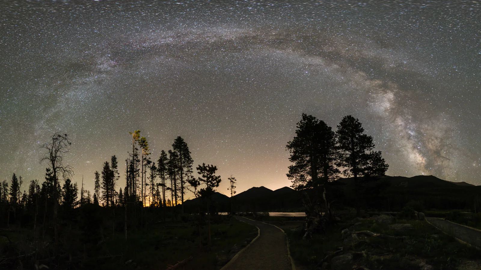
Rocky Mountain National Park asks hikers to solve three problems at once: access, altitude, and weather. Bear Lake Road, Trail Ridge Road, Wild Basin, Longs Peak, Lumpy Ridge, and the west-side trailheads are separate planning zones. A trail that looks modest on paper can begin above 9,000 feet, while a high ridge can become unsafe before an afternoon storm reaches the valley.
These twenty-four routes move from Grand Lake and the Continental Divide to Bear Lake, Moraine Park, Wild Basin, Longs Peak, and the east-side foothills. Short accessible loops sit beside tundra walks, lake days, waterfall routes, and major alpine objectives. Distances and elevation gains come from the preserved geometry used for each map and profile, so they may differ slightly from rounded signs or a different trailhead variation.
Planning information was checked on August 31, 2026. Roads, shuttle schedules, snow, fire restrictions, parking, and climbing conditions change faster than a static guide. Read the live alert and weather panels, check the official conditions page before departure, and let closures, signs, and ranger directions override the mapped line.
Live park weather
Rocky Mountain National Park
Beaver Meadows Visitor Center
Loading the latest conditions and alerts…
What changes a hiking day here
Match the reservation to the trailhead
In 2026, timed entry applies from May 22 into October. The Bear Lake Road permit covers that corridor and the rest of the park from 5 a.m. to 6 p.m.; the rest-of-park permit applies outside Bear Lake Road from 9 a.m. to 2 p.m. A reservation is separate from the entrance pass. Verify current dates and exceptions before building a dawn or shuttle plan.
Use the shuttle as part of the route
Bear Lake and Glacier Gorge parking fill early. In the operating season, the free Bear Lake and Moraine Park shuttles connect Park & Ride with major corridor trailheads. The bus does not solve access to Trail Ridge Road, Wild Basin, Longs Peak, Lumpy Ridge, or Grand Lake, so those hikes need their own legal parking plan.
Build the day around treeline
Thunderstorms and lightning are common from June through September. For Mount Ida, Tombstone Ridge, Flattop, Twin Sisters, Chasm Lake, and Longs Peak, start early enough to descend exposed terrain before clouds build. If thunder is audible, do not wait for rain; leave summits, ridges, open tundra, isolated trees, rock shelters, and water.
Treat elevation as part of the difficulty
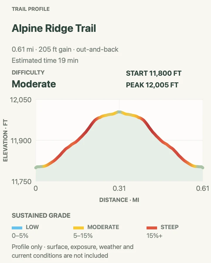
Even the short Alpine Ridge walk begins near 12,000 feet, and several long routes climb well above treeline. Acclimatize before a major objective, carry more layers than the valley forecast suggests, eat and drink steadily, and descend when headache, nausea, unusual fatigue, confusion, or poor coordination appear.
Expect winter conditions beyond winter
Snow and ice commonly cover high trails from autumn into late spring, and shaded patches can persist into summer. Waterproof boots and traction may be appropriate around Bear Lake when lower roads are dry. An ice axe, flotation, or avalanche judgment requires real skill; a map does not make a snow-covered route safe.
Keep wildlife and water at a distance
Elk, moose, bears, and smaller animals use trail corridors and lake edges. Never feed them, give them room, and change plans when an animal blocks the route. Streams and waterfalls run cold and fast during snowmelt; stay off wet rocks and keep back from unprotected edges. Treat all backcountry water before drinking.
Leave pets off park trails
Pets are prohibited on Rocky Mountain National Park trails, tundra, and meadows. They may be present only in motor-vehicle-accessible areas where rules allow, on a leash no longer than six feet. Choose a legal destination outside the park rather than leaving an animal in a vehicle.
| Trail | Distance | Time | Difficulty | Best for |
|---|---|---|---|---|
| Cascade Falls | 6.8 miles round trip | About 3 hours 30 minutes | Moderate | A west-side forest-and-waterfall day |
| Mount Ida Trail | 9.5 miles round trip | About 6 hours 45 minutes | Hard | A long tundra ridge and alpine summit |
| Lone Pine Lake via East Inlet Trail | 10.6 miles round trip | About 5 hours | Hard | A quieter west-side lake objective |
| Alpine Ridge Trail | 0.6 mile round trip | About 20 minutes | Moderate | A short introduction to alpine tundra |
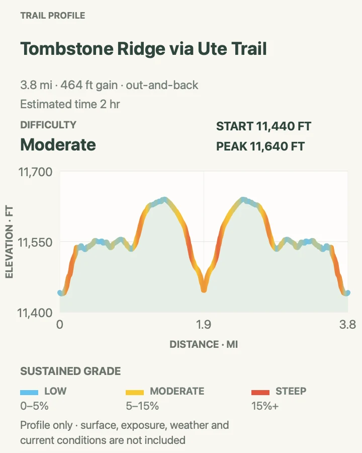
| Tombstone Ridge via Ute Trail | 3.8 miles round trip | About 2 hours | Moderate | A rolling tundra walk without a summit push |
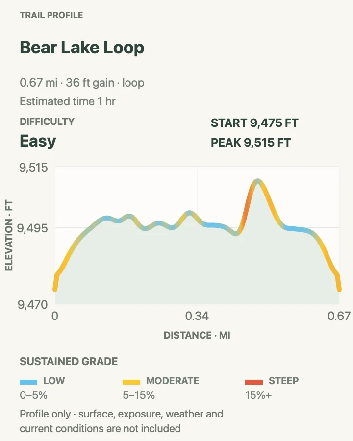
| Bear Lake Loop | 0.7 mile loop | About 45 to 60 minutes | Easy | A short high-elevation lake circuit |
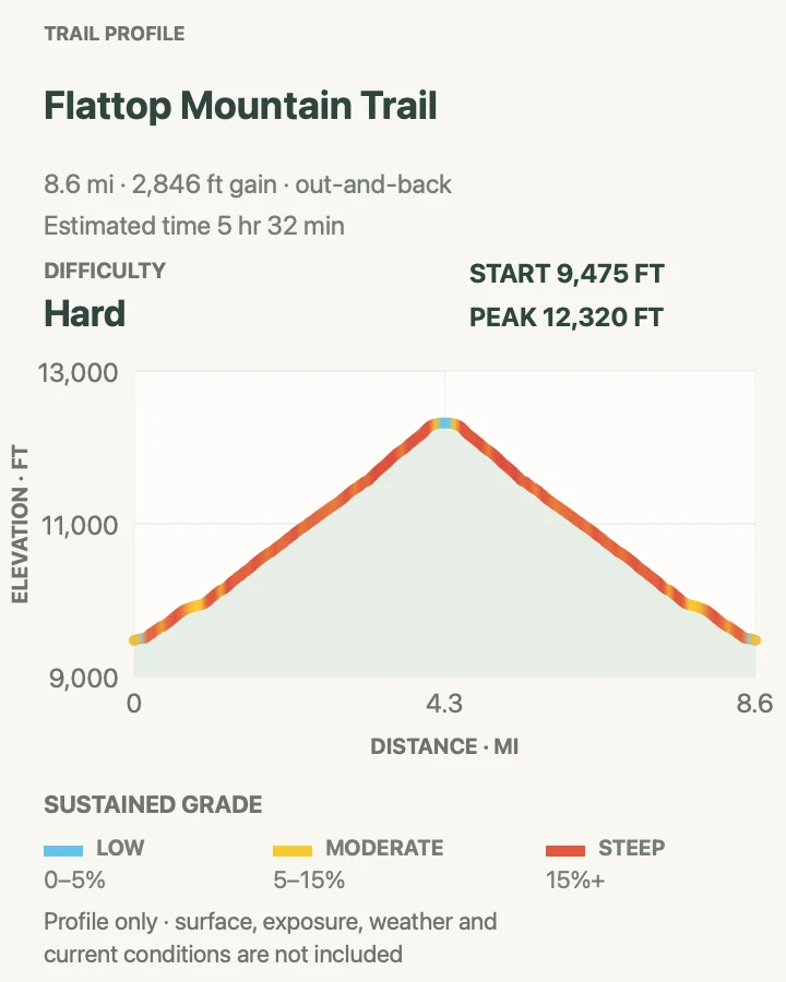
| Flattop Mountain Trail | 8.6 miles round trip | About 5 hours 30 minutes | Hard | A sustained climb from forest to tundra |
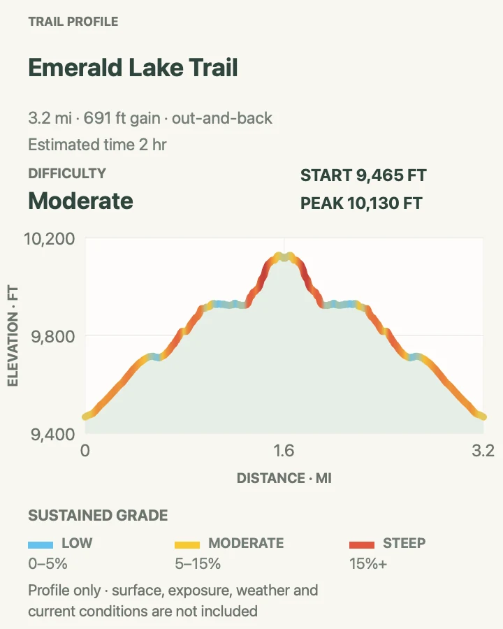
| Emerald Lake Trail | 3.2 miles round trip | About 2 hours | Moderate | Three named lakes on one compact climb |
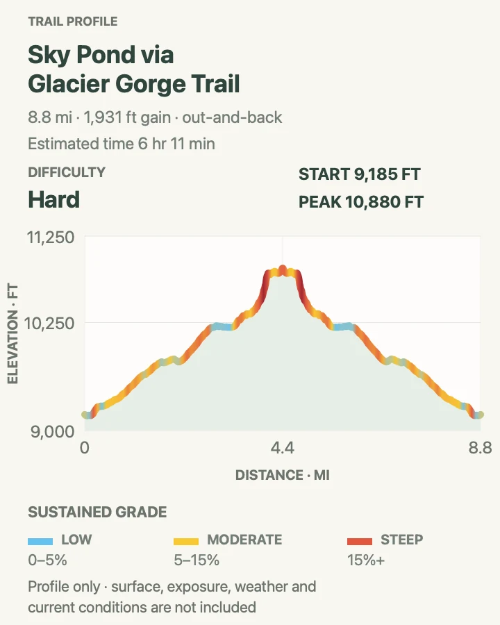
| Sky Pond via Glacier Gorge Trail | 8.8 miles round trip | About 6 hours | Hard | A full Glacier Gorge lake-and-waterfall route |
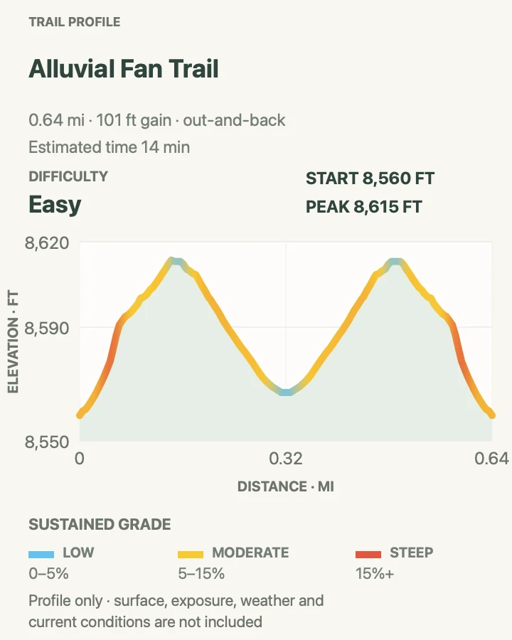
| Alluvial Fan Trail | 0.6 mile round trip | About 20 to 40 minutes | Easy | An accessible cascade and geology stop |
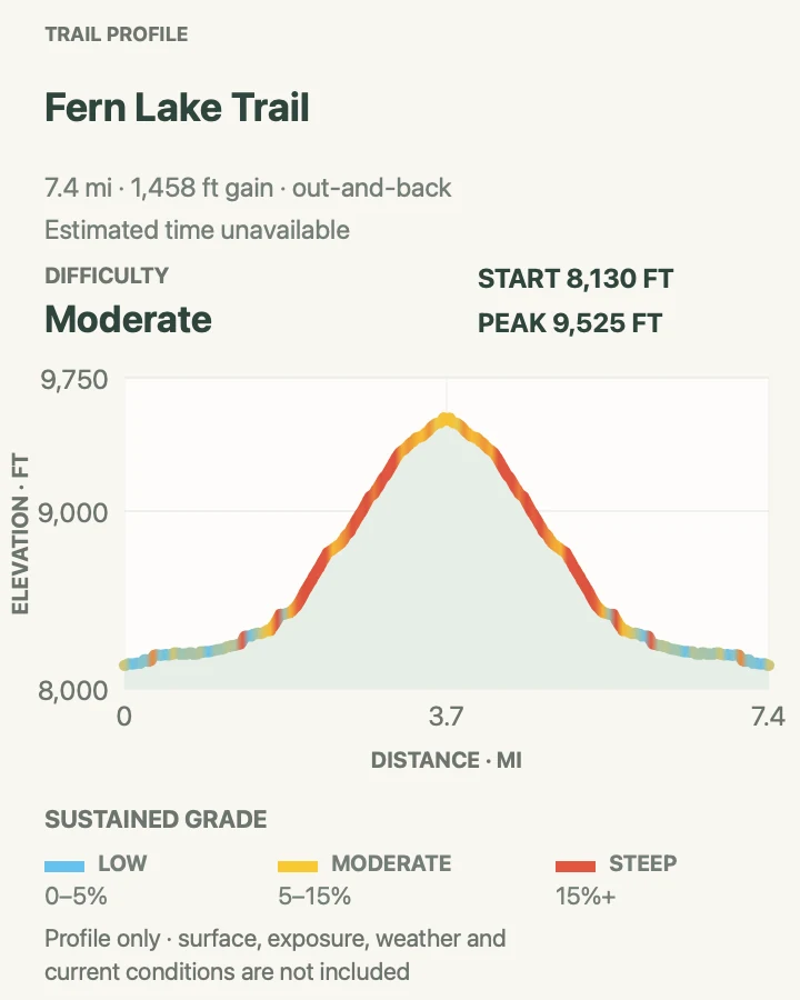
| Fern Lake Trail | 7.4 miles round trip | About 4 hours | Moderate | A river corridor that climbs to a subalpine lake |
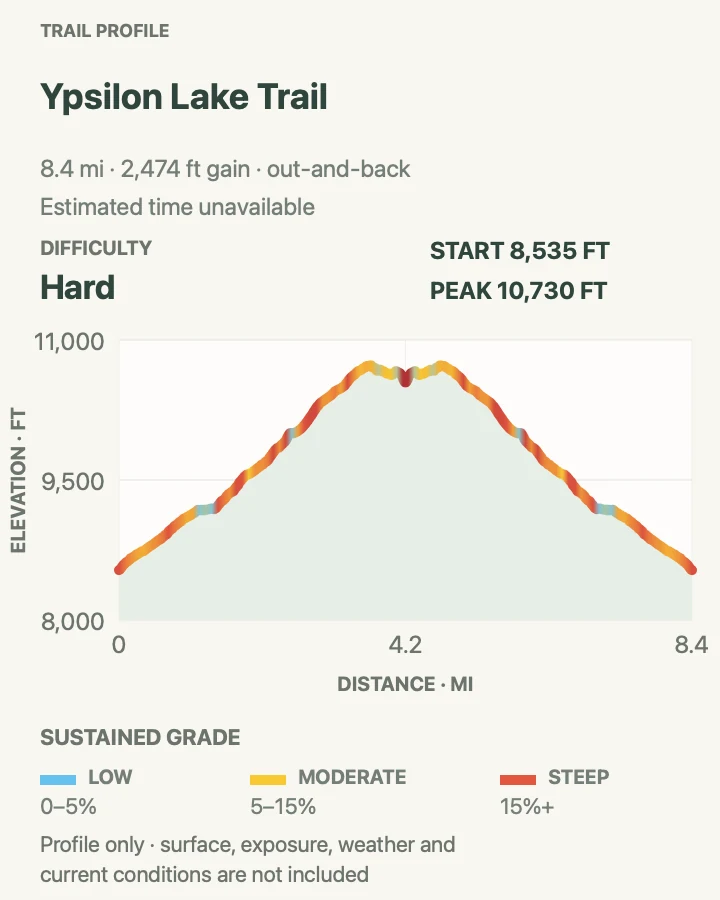
| Ypsilon Lake Trail | 8.4 miles round trip | About 5 hours | Hard | A strenuous forest climb to a quieter lake |
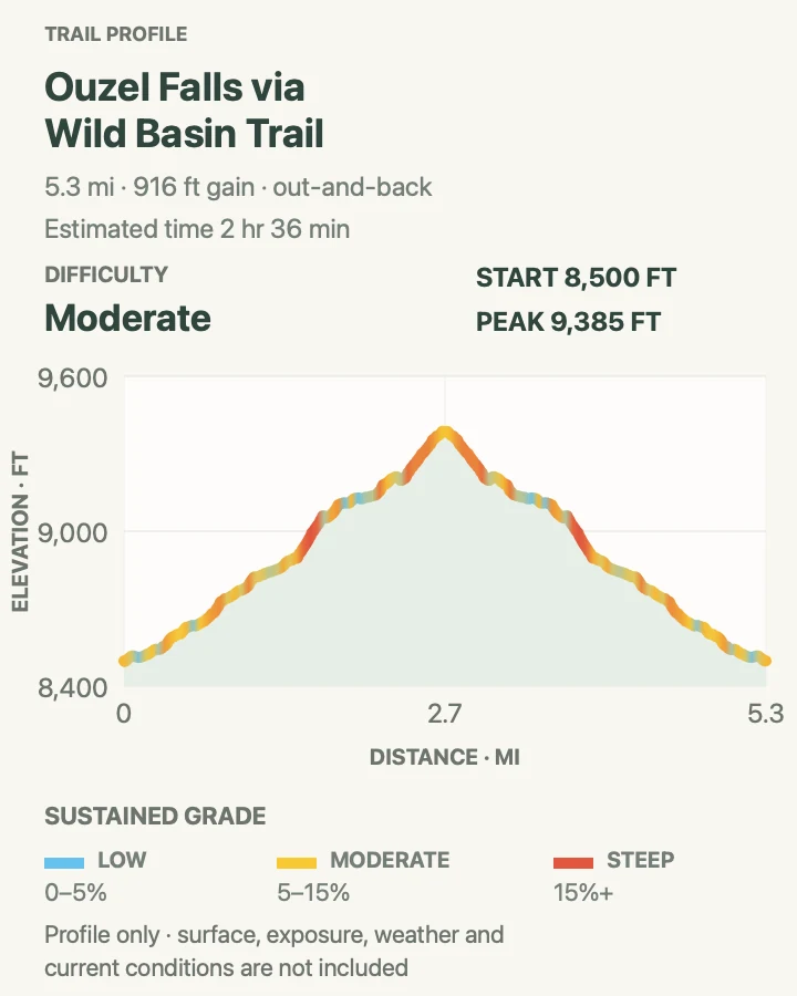
| Ouzel Falls via Wild Basin Trail | 5.4 miles round trip | About 3 hours | Moderate | A Wild Basin waterfall route with several cascades |
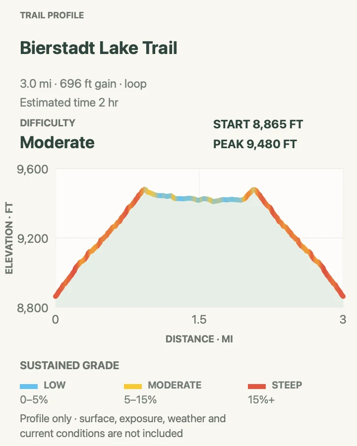
| Bierstadt Lake Trail | 3.0-mile loop | About 2 hours | Moderate | Aspen, moraine views, and a compact lake loop |
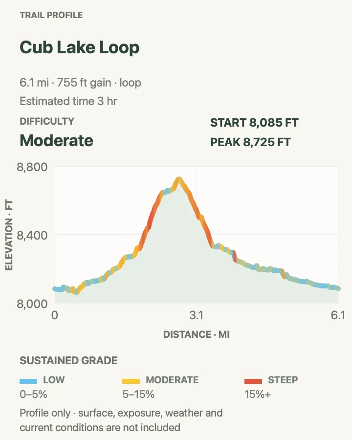
| Cub Lake Loop | 6.1-mile loop | About 3 hours | Moderate | Moraine Park meadows and a varied forest loop |
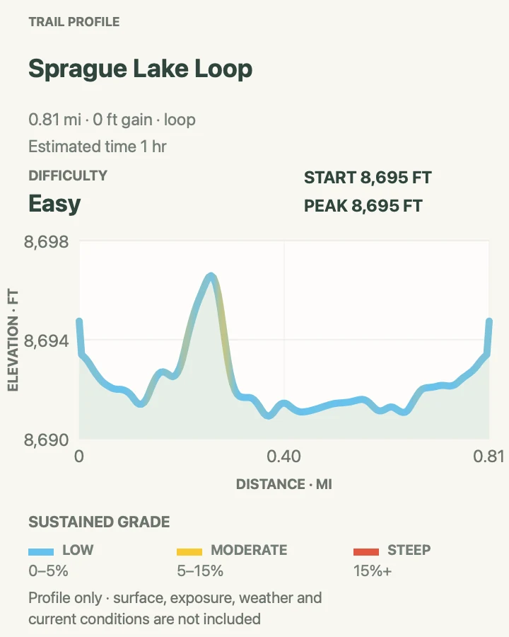
| Sprague Lake Loop | 0.8-mile loop | About 45 to 60 minutes | Easy | An accessible lake circuit with benches |
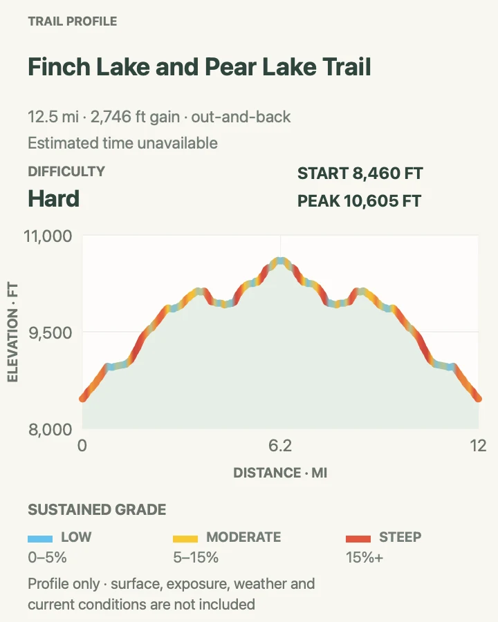
| Finch Lake and Pear Lake Trail | 12.5 miles round trip | About 7 hours | Hard | A long Wild Basin route linking two lakes |
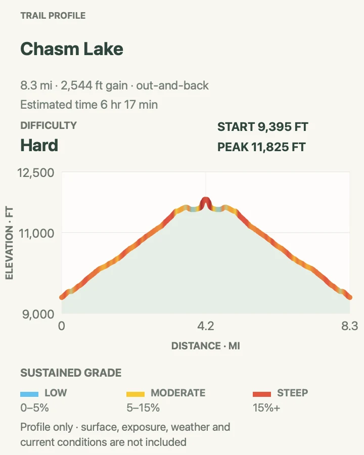
| Chasm Lake | 8.3 miles round trip | About 6 hours | Hard | A high alpine lake below the Diamond |
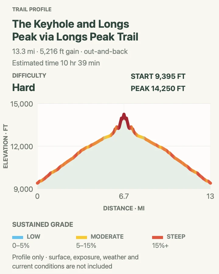
| Longs Peak Keyhole Route | 13.3 miles round trip | 10 to 15 hours | Mountaineering route | Experienced climbers prepared for exposed scrambling |
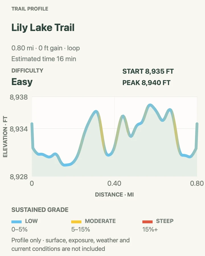
| Lily Lake Trail | 0.8-mile loop | About 20 to 45 minutes | Easy | A short lake walk on the park's southeast edge |
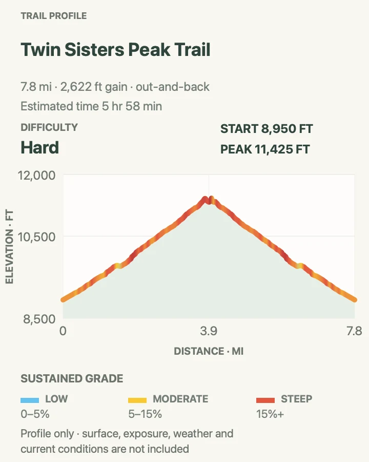
| Twin Sisters Peak Trail | 7.8 miles round trip | About 6 hours | Hard | A demanding summit with Longs Peak views |
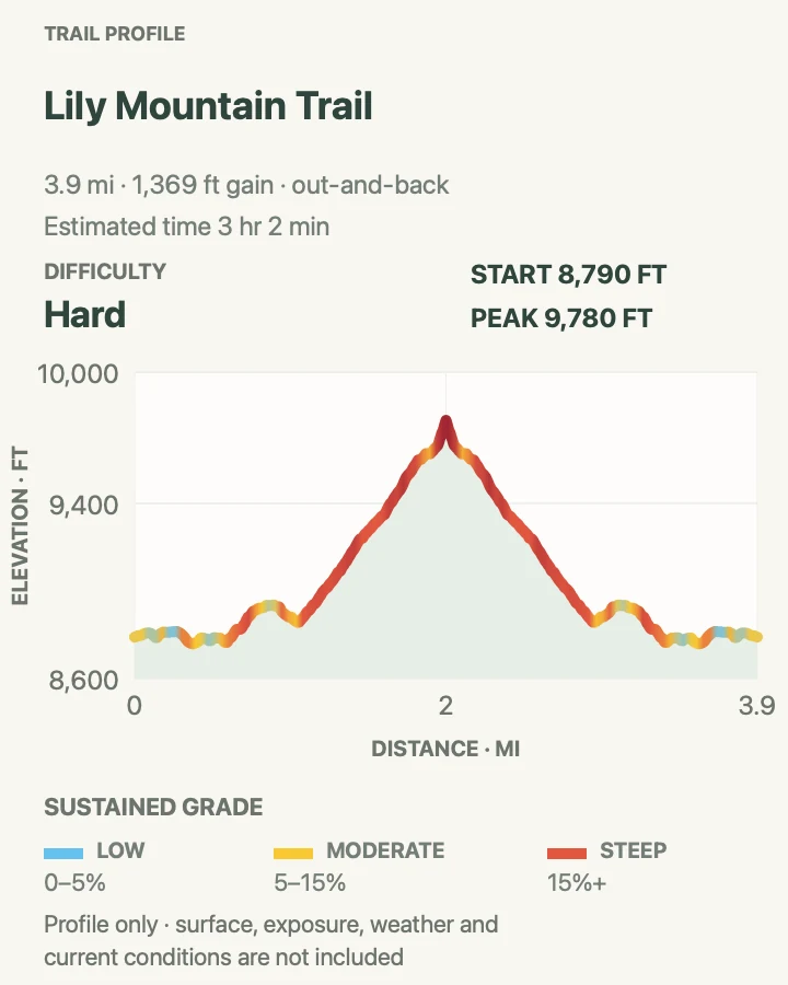
| Lily Mountain Trail | 3.9 miles round trip | About 3 hours | Hard | A shorter but steep foothill summit |
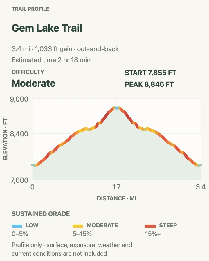
| Gem Lake Trail | 3.4 miles round trip | About 2 hours 15 minutes | Moderate | Granite formations and a compact east-side climb |
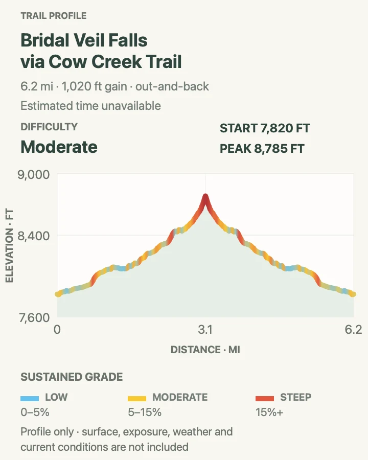
| Bridal Veil Falls via Cow Creek Trail | 6.2 miles round trip | About 3 hours 30 minutes | Moderate | A quieter ranch corridor ending at a waterfall |
Cascade Falls
- Distance
- 6.8 miles round trip
- Elevation gain
- 810 feet
- Time
- About 3 hours 30 minutes
- Difficulty
- Moderate
- Route type
- Out and back
- Parking
- Use the North Inlet Trailhead area at the east end of Grand Lake and obey signed spaces and seasonal access restrictions.
- Best time
- Morning in the snow-free season, after checking west-side trail and fire conditions.
- Pets
- Pets are not allowed on park trails. Trained service animals are allowed.
Cascade Falls follows the North Inlet corridor from Grand Lake through lodgepole forest to a broad, rocky cascade. The grade is steadier than the park's summit routes, but the distance and the warmer west-side start make it a real half-day commitment.
The waterfall is the turnaround for this guide; continuing toward North Inlet Junction changes the trip. Snowmelt raises water volume and the consequence of wet rock, so enjoy the falls from dry established ground instead of edging toward the channel.
What helps on this route
- Start with the current west-side fire and closure map.
- Carry treated water rather than relying on North Inlet.
Terrain and access: Forested valley trail with moderate climbing, roots, rock, stream proximity, and a slippery waterfall zone.

Mount Ida Trail
- Distance
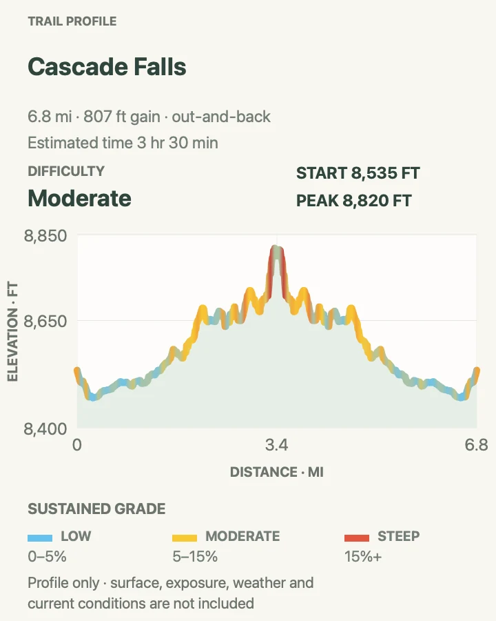
- 9.5 miles round trip
- Elevation gain
- 2,540 feet
- Time
- About 6 hours 45 minutes
- Difficulty
- Hard
- Route type
- Out and back
- Parking
- Use the signed Milner Pass/Poudre Lake parking area on Trail Ridge Road; there is no trailhead shuttle.
- Best time
- A clear summer morning with Trail Ridge Road open and a return below exposed tundra before storms.
- Pets
- Pets are not allowed on park trails. Trained service animals are allowed.
Mount Ida begins high and stays exposed for much of its distance. After the forested approach, the route follows open tundra and a broad ridge toward the summit, where wind and fast weather matter more than trail engineering.
The mild-looking horizon can disguise both altitude and the long retreat. Use the first building clouds as a turnaround signal, protect tundra by staying on durable tread, and do not approach wildlife for a photograph.
What helps on this route
- Check Trail Ridge Road status before leaving either side of the park.
- Carry windproof layers even when Grand Lake and Estes Park are warm.
Terrain and access: High-elevation trail and open tundra ridge with prolonged exposure, rock, wind, and little lightning shelter.

Lone Pine Lake via East Inlet Trail
- Distance
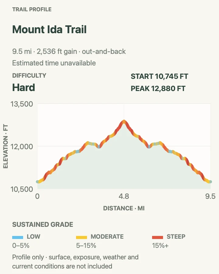
- 10.6 miles round trip
- Elevation gain
- 2,060 feet
- Time
- About 5 hours
- Difficulty
- Hard
- Route type
- Out and back
- Parking
- Begin at the East Inlet Trailhead on the east side of Grand Lake and use only the designated trailhead lot.
- Best time
- Early morning from midsummer into early fall, once the route is snow-free.
- Pets
- Pets are not allowed on park trails. Trained service animals are allowed.
The East Inlet route passes Adams Falls country without treating that short spur as a second hike, then continues deep into the valley toward Lone Pine Lake. Forest, meadow, creek crossings, and a long gradual climb make the day varied without requiring a summit.
Distance is the main constraint. Turnaround time matters because the return to Grand Lake is long even after the climbing ends, and afternoon weather can still reach the lake corridor.
What helps on this route
- Record the junction where the East Inlet route leaves the busy lower falls area.
- Carry a headlamp for an unexpectedly slow return.
Terrain and access: Long forest-and-meadow route with sustained climbing, roots, rocks, water crossings, and a remote lake finish.

Alpine Ridge Trail
- Distance
- 0.6 mile round trip
- Elevation gain
- 210 feet
- Time
- About 20 minutes
- Difficulty
- Moderate
- Route type
- Out and back
- Parking
- Park at the Alpine Visitor Center while Trail Ridge Road and the visitor-center lot are open.
- Best time
- A calm clear morning during the short Trail Ridge Road season.
- Pets
- Pets are not allowed on park trails. Trained service animals are allowed.
Alpine Ridge is brief but begins near 12,000 feet. A stair-stepped path climbs above the visitor center to an exposed viewpoint, compressing thin air, wind, and tundra into a route that is much harder than its mileage suggests.
Move at an altitude-appropriate pace and turn around immediately when thunder or dark cloud approaches. Stay on the constructed tread; plants beside it may take decades to recover from one shortcut.
What helps on this route
- Add a warm layer before leaving the vehicle.
- Do not use the trail as an acclimatization test if anyone already feels unwell.
Terrain and access: Steep paved-and-stair path on fully exposed tundra at very high elevation.

Tombstone Ridge via Ute Trail
- Distance
- 3.8 miles round trip
- Elevation gain
- 460 feet
- Time
- About 2 hours
- Difficulty
- Moderate
- Route type
- Out and back
- Parking
- Use the signed Ute Crossing pullout on Trail Ridge Road; do not create a roadside space when it is full.
- Best time
- Early morning with dry tundra and a stable forecast.
- Pets
- Pets are not allowed on park trails. Trained service animals are allowed.
The Ute Trail leaves Trail Ridge Road and rolls across open alpine country toward Tombstone Ridge. The measured gain is moderate, but exposure is continuous and the return can face wind that was behind you outbound.
Choose a conservative turnaround because the route offers no meaningful lightning shelter. The trail also crosses fragile tundra habitat, so pass other hikers on rock or durable tread rather than widening the path.
What helps on this route
- Save the car location; similar pullouts can be confusing on the return drive.
- Carry eye and skin protection for wind and intense alpine sun.
Terrain and access: Open tundra trail with rolling grades, embedded rock, wind, and complete weather exposure.

Bear Lake Loop
- Distance
- 0.7 mile loop
- Elevation gain
- 35 feet
- Time
- About 45 to 60 minutes
- Difficulty
- Easy
- Route type
- Loop
- Parking
- Use Bear Lake Park & Ride and the seasonal shuttle when the trailhead lot is full; the Bear Lake timed-entry rules apply in season.
- Best time
- Early morning or later afternoon, with traction in snow and ice season.
- Pets
- Pets are not allowed on park trails. Trained service animals are allowed.
Bear Lake Loop circles the shoreline below Hallett Peak and serves a different purpose from the longer routes leaving the same trailhead. It is the park's compact lake walk: easy to shorten, rich in viewpoints, and busy enough that timing shapes the experience.
Easy does not mean summer-only. NPS advises waterproof boots and traction when snow and ice cover the path, commonly from late October into early June. Yield at narrow shoreline sections and stay out of restoration areas.
What helps on this route
- Take the shuttle rather than waiting at a full lot.
- Check the surface before assuming a stroller or mobility device can complete the full loop.
Terrain and access: Mostly gentle lakeside tread with rock, roots, seasonal ice, and several narrow viewpoints.

Flattop Mountain Trail
- Distance
- 8.6 miles round trip
- Elevation gain
- 2,850 feet
- Time
- About 5 hours 30 minutes
- Difficulty
- Hard
- Route type
- Out and back
- Parking
- Start at Bear Lake Trailhead using the timed-entry and seasonal shuttle plan for Bear Lake Road.
- Best time
- Predawn or early morning in stable summer weather.
- Pets
- Pets are not allowed on park trails. Trained service animals are allowed.
Flattop Mountain climbs out of the Bear Lake forest, passes successive overlooks, and reaches broad alpine terrain on the Continental Divide. The route's nearly continuous ascent makes the profile more informative than the simple out-and-back label.
Above treeline, wind and storms erase the comfort of a well-used trail. Set a turnaround time before starting, watch the sky behind you, and keep enough energy for the long descent over rock and roots.
What helps on this route
- Board the earliest practical shuttle or walk from an authorized start.
- Pack gloves, a hat, rain shell, and emergency insulation.
Terrain and access: Sustained forest climb becoming rocky and fully exposed above treeline.

Emerald Lake Trail
- Distance
- 3.2 miles round trip
- Elevation gain
- 690 feet
- Time
- About 2 hours
- Difficulty
- Moderate
- Route type
- Out and back
- Parking
- Start at Bear Lake Trailhead; use the Bear Lake Road reservation and seasonal shuttle system when required.
- Best time
- Early morning year-round, with winter traction and navigation skills when snow covers the trail.
- Pets
- Pets are not allowed on park trails. Trained service animals are allowed.
Emerald Lake is the single representative for the nested Nymph–Dream–Emerald corridor. The trail climbs past the first two lakes to a cirque beneath Hallett Peak, adding a clear terminal destination without counting each shorter turnaround as a separate hike.
Crowding and snow are the practical variables. Keep the center of the tread open at lake viewpoints, and in winter do not follow footprints blindly where wind or drift has obscured the maintained route.
What helps on this route
- Use the mobile map to confirm junctions instead of using other groups as navigation.
- Carry traction whenever the Bear Lake area reports packed snow or ice.
Terrain and access: Rocky forest trail with steady climbing, lake-edge congestion, and persistent winter snow.

Sky Pond via Glacier Gorge Trail
- Distance
- 8.8 miles round trip
- Elevation gain
- 1,930 feet
- Time
- About 6 hours
- Difficulty
- Hard
- Route type
- Out and back
- Parking
- Use Park & Ride and the Bear Lake shuttle for Glacier Gorge Trailhead; its small lot fills very early.
- Best time
- Very early on a dry summer day, after checking snow and waterfall conditions.
- Pets
- Pets are not allowed on park trails. Trained service animals are allowed.
Sky Pond represents the longer Glacier Gorge family in this guide, absorbing the shared Alberta Falls and Loch corridor instead of listing those nested approaches separately. Beyond The Loch, the route grows rougher and reaches the wet, steep passage beside Timberline Falls before the upper lakes.
That passage can be the day's decision point. Water, ice, exposure, or descending traffic may make a retreat sensible even when the lower trail is dry. Protect the return schedule; the route remains long after leaving Sky Pond.
What helps on this route
- Keep waterproof layers and traction appropriate to the posted conditions.
- Wait for a safe gap at the steep waterfall passage rather than passing on exposed rock.
Terrain and access: Busy lower trail leading to rougher high-country rock, a wet steep scramble, and exposed alpine basins.

Alluvial Fan Trail
- Distance
- 0.6 mile round trip
- Elevation gain
- 100 feet
- Time
- About 20 to 40 minutes
- Difficulty
- Easy
- Route type
- Out and back
- Parking
- Use the signed east or west Alluvial Fan parking area on Endovalley Road; a vault toilet is at the west lot.
- Best time
- Morning or late afternoon, especially during fall color.
- Pets
- Pets are not allowed on park trails. Trained service animals are allowed.
The reconstructed path reaches the Alluvial Fan's boulder field and a 56-foot bridge over the Roaring River. Interpretive signs connect the visible debris to the 1982 Lawn Lake dam failure, making this more than a quick waterfall photograph.
Accessibility depends on the chosen side, current surface, and weather. Stay on the path and bridge; the cascade and boulders are not a safe place to test footing during high water or ice.
What helps on this route
- Use the west approach for the park's designated accessible path information.
- Keep children close near moving water and boulder gaps.
Terrain and access: Designed path through a boulder fan to a bridge and cascade, with seasonal ice and spray.

Fern Lake Trail
- Distance
- 7.4 miles round trip
- Elevation gain
- 1,460 feet
- Time
- About 4 hours
- Difficulty
- Moderate
- Route type
- Out and back
- Parking
- Use the authorized Moraine Park/Fern Lake access plan and seasonal shuttle; check whether the final road segment is open to vehicles.
- Best time
- Morning from late spring through fall, after checking snow, fire, and road conditions.
- Pets
- Pets are not allowed on park trails. Trained service animals are allowed.
Fern Lake Trail follows the Big Thompson corridor past The Pool, then gains elevation more decisively toward Fern Falls and the lake. The change from valley walking to steeper forest makes the return feel different from the outbound leg.
Access to the trailhead varies with seasonal road and shuttle operations. Confirm the actual start before trusting the mileage, and add walking distance if the road is closed beyond the bus or parking stop.
What helps on this route
- Check the Bear Lake Road corridor page for current Fern Lake access.
- Keep away from slick rocks at The Pool and Fern Falls.
Terrain and access: Riverside forest followed by steeper rocky climbing, roots, waterfall spray, and a high lake basin.

Ypsilon Lake Trail
- Distance
- 8.4 miles round trip
- Elevation gain
- 2,470 feet
- Time
- About 5 hours
- Difficulty
- Hard
- Route type
- Out and back
- Parking
- Use the Lawn Lake Trailhead lot off Fall River Road; it also serves several long Mummy Range routes.
- Best time
- Early on a dry summer or early-fall day.
- Pets
- Pets are not allowed on park trails. Trained service animals are allowed.
Ypsilon Lake shares only the initial Lawn Lake approach before turning toward a separate drainage. The route climbs through forest, passes Chipmunk Lake, and continues over rougher ground to its terminal lake beneath the Mummy Range.
The destination sits far enough from the road that a late start compounds every problem. Carry navigation, layers, and a turnaround time, and expect fallen trees or wet tread to slow travel after storms.
What helps on this route
- Confirm the Ypsilon junction on the outbound climb.
- Bring insect protection during wet summer periods.
Terrain and access: Long forest ascent with roots, rocks, creek proximity, and a rougher subalpine finish.

Ouzel Falls via Wild Basin Trail
- Distance
- 5.4 miles round trip
- Elevation gain
- 920 feet
- Time
- About 3 hours
- Difficulty
- Moderate
- Route type
- Out and back
- Parking
- Use the designated Wild Basin Trailhead area and confirm the seasonal entrance-road status before driving in.
- Best time
- A cool morning from late spring through fall, after checking snowmelt and trail conditions.
- Pets
- Pets are not allowed on park trails. Trained service animals are allowed.
The Wild Basin trail follows North St. Vrain Creek past Copeland Falls and Calypso Cascades before climbing to Ouzel Falls. Those lower waterfalls are part of one connected outing here rather than separate entries that would repeat the same corridor.
Snowmelt makes the creek forceful and the viewing rocks slick. Stay on established tread and dry overlooks, keep children close, and remember that the return still includes rough stone and roots after the main descent begins.
What helps on this route
- Arrive early; the narrow Wild Basin road and trailhead parking have limited capacity.
- Keep waterproof layers handy for spray and fast mountain showers.
Terrain and access: Forested creek trail with roots, stone steps, repeated cascades, moderate climbing, and wet rock near the falls.

Bierstadt Lake Trail
- Distance
- 3.0-mile loop
- Elevation gain
- 700 feet
- Time
- About 2 hours
- Difficulty
- Moderate
- Route type
- Loop
- Parking
- Use the Bierstadt Lake shuttle stop; the adjacent lot is small and lies inside the Bear Lake Road timed-entry corridor.
- Best time
- Morning in summer or during fall aspen color.
- Pets
- Pets are not allowed on park trails. Trained service animals are allowed.
From the Bierstadt trailhead, switchbacks climb through aspen with open views toward Sprague Lake and Longs Peak before the route circles the lake. Starting here makes the climb sharper than the alternative connection from Bear Lake.
The loop geometry avoids presenting the two trailhead approaches as separate hikes. At intersections, follow the mapped circuit and verify the return branch to the Bierstadt shuttle stop.
What helps on this route
- Use the shuttle instead of waiting for the small lot.
- Photograph the return-junction sign before entering the lake loop.
Terrain and access: Steep moraine switchbacks, aspen forest, and a gentler wooded lake circuit.

Cub Lake Loop
- Distance
- 6.1-mile loop
- Elevation gain
- 750 feet
- Time
- About 3 hours
- Difficulty
- Moderate
- Route type
- Loop
- Parking
- Use the Cub Lake Trailhead/Moraine Park access and seasonal shuttle plan within the Bear Lake Road corridor.
- Best time
- Morning in spring through fall, after checking burn-area and wildlife conditions.
- Pets
- Pets are not allowed on park trails. Trained service animals are allowed.
Cub Lake combines open Moraine Park edges, wetland habitat, forest, and a lake rather than repeating the adjacent Fern Lake out-and-back. The loop's two halves differ in exposure and grade, which makes direction and current trail condition worth checking.
Elk and other wildlife frequently use the meadows. Give animals a wide corridor, stay on durable tread in burned or recovering areas, and watch for unstable dead trees when wind rises.
What helps on this route
- Ask which loop direction has the better current footing.
- Do not approach elk for a clearer photograph.
Terrain and access: Meadow, wetland edge, rolling forest trail, roots, rock, and sections affected by past fire.

Sprague Lake Loop
- Distance
- 0.8-mile loop
- Elevation gain
- 0 feet
- Time
- About 45 to 60 minutes
- Difficulty
- Easy
- Route type
- Loop
- Parking
- Use the Sprague Lake lot or the seasonal shuttle stop inside the Bear Lake Road corridor.
- Best time
- Early morning for calm water and lower traffic.
- Pets
- Pets are not allowed on park trails. Trained service animals are allowed.
Sprague Lake's nearly level circuit has benches and lookout points along the east shore, with Continental Divide views reflected across the water in calm conditions. NPS identifies it as wheelchair and stroller accessible, subject to the actual surface and weather on the day.
The lake's ease makes it useful for acclimatization or a recovery day, not a reason to leave weather gear behind. Ice, wind, or a storm can change the surface quickly.
What helps on this route
- Check the accessible parking and current path condition before circling.
- Yield at fishing and viewing pullouts instead of stepping into shoreline vegetation.
Terrain and access: Broad, nearly level developed path with benches, lake-edge viewpoints, and seasonal snow or ice.

Finch Lake and Pear Lake Trail
- Distance
- 12.5 miles round trip
- Elevation gain
- 2,750 feet
- Time
- About 7 hours
- Difficulty
- Hard
- Route type
- Out and back
- Parking
- Use the designated Wild Basin trailhead access serving the Finch Lake route; confirm seasonal road status before the drive.
- Best time
- A predawn summer start after high-country snow has retreated.
- Pets
- Pets are not allowed on park trails. Trained service animals are allowed.
Finch and Pear Lakes form one complete route, not two padded entries. Long switchbacks climb from Wild Basin, the trail reaches Finch Lake, and the more remote continuation ends at Pear Lake beneath high granite terrain.
The second lake materially increases both distance and commitment. Decide at Finch whether daylight, weather, and the group still support the continuation; the return repeats every mile of the approach.
What helps on this route
- Carry a headlamp and an offline map for the long forest return.
- Turn around at Finch if clouds are already building over the Divide.
Terrain and access: Long forest switchbacks, creek crossings, granite, subalpine lakes, and sustained cumulative climbing.

Chasm Lake
- Distance
- 8.3 miles round trip
- Elevation gain
- 2,540 feet
- Time
- About 6 hours
- Difficulty
- Hard
- Route type
- Out and back
- Parking
- Use the Longs Peak Trailhead lot on Highway 7; arrive only with a legal space and do not block emergency or roadside access.
- Best time
- Before dawn in summer, after checking the current Longs Peak conditions report.
- Pets
- Pets are not allowed on park trails. Trained service animals are allowed.
Chasm Lake follows the maintained Longs Peak trail to Chasm Junction, then turns toward a separate lake objective below the Diamond. The Chasm Crossing traverses a steep slope and may hold snow, ice, or wet slabs even when the lower forest is dry.
This route shares its lower approach with the Keyhole climb but is not a summit variant. Check the specific crossing report, keep a noon-or-earlier descent in mind, and turn around before the lake when traction or weather exceeds the group's skill.
What helps on this route
- Read the dated Chasm Crossing update, not only the valley forecast.
- Carry poles only if they improve—not replace—careful footwork on the slabs.
Terrain and access: Steep forest climb to exposed alpine trail, a consequential slab crossing, boulders, and a high lake basin.

Longs Peak Keyhole Route
- Distance
- 13.3 miles round trip
- Elevation gain
- 5,220 feet
- Time
- 10 to 15 hours
- Difficulty
- Mountaineering route
- Route type
- Out and back climb
- Parking
- Start at Longs Peak Trailhead on Highway 7 with a legal space; the lot often fills before dawn.
- Best time
- Only in appropriate conditions, after acclimatization and a current ranger/conditions check.
- Pets
- Pets are not allowed on park trails. Trained service animals are allowed.
NPS is explicit: the Keyhole Route is not an ordinary hike. The maintained trail ends at the Boulder Field; beyond it, the route crosses exposed ledges, loose rock, the Trough, the Narrows, and the Homestretch, where an unroped fall can be fatal. The map records the established route but cannot teach route finding, movement skills, or judgment.
Its separate Longs Peak summit objective justifies the shared lower corridor with Chasm Lake, but only as a clearly labeled climbing route. Current snow, ice, water on rock, wind, lightning, fatigue, or crowding can require retreat. Speak with a ranger, study the detailed Keyhole guidance, and be back below treeline before afternoon storms.
What helps on this route
- Carry a headlamp, waterproof insulation, extra food and water, first aid, and a detailed route description.
- Turn around when conditions or pace miss the plan; reaching the Keyhole is not permission to continue.
Terrain and access: Maintained trail to the Boulder Field followed by exposed mountaineering terrain, loose rock, scrambling, narrow ledges, and steep slabs.

Lily Lake Trail
- Distance
- 0.8-mile loop
- Elevation gain
- 0 feet
- Time
- About 20 to 45 minutes
- Difficulty
- Easy
- Route type
- Loop
- Parking
- Use the signed Lily Lake parking area on Highway 7; spaces are limited and timed-entry rules may apply in season.
- Best time
- Morning or evening in the snow-free season.
- Pets
- Pets are not allowed on park trails. Trained service animals are allowed.
Lily Lake Loop stays close to the water and gives a low-mileage alternative to the nearby summit trails. Views open toward Longs Peak and Twin Sisters, while wetland habitat makes remaining on the established path especially important.
Parking, not endurance, is usually the constraint. Do not improvise a Highway 7 shoulder space, and check the actual surface before assuming the full circuit meets a group's accessibility needs.
What helps on this route
- Return later if every signed space is occupied.
- Give anglers and wildlife watchers room at shoreline pullouts.
Terrain and access: Gentle developed lake path with wetland edges, short boardwalk-like sections, and seasonal ice.

Twin Sisters Peak Trail
- Distance
- 7.8 miles round trip
- Elevation gain
- 2,620 feet
- Time
- About 6 hours
- Difficulty
- Hard
- Route type
- Out and back
- Parking
- Use the signed Twin Sisters trailhead parking on Highway 7 and respect closures or restricted roadside areas.
- Best time
- Early morning in dry summer or early-fall conditions.
- Pets
- Pets are not allowed on park trails. Trained service animals are allowed.
Twin Sisters climbs steadily from Highway 7 through forest and past areas altered by landslide and erosion before reaching exposed upper slopes. The summit area gives a broad view toward Longs Peak without using the Longs Peak climbing corridor.
Loose rock and weather complicate the final section. Leave the summit before thunder develops, avoid unstable shortcuts, and expect the descent to demand more concentration than the lower switchbacks.
What helps on this route
- Check the latest trail alignment and closure notices.
- Use poles only where they help control the long rocky descent.
Terrain and access: Sustained forest switchbacks, eroded or rocky sections, and an exposed summit finish.

Lily Mountain Trail
- Distance
- 3.9 miles round trip
- Elevation gain
- 1,370 feet
- Time
- About 3 hours
- Difficulty
- Hard
- Route type
- Out and back
- Parking
- Use only the signed Lily Mountain trailhead spaces along Highway 7; do not widen the parking footprint.
- Best time
- A dry morning before heat and thunderstorms build.
- Pets
- Pets are not allowed on park trails. Trained service animals are allowed.
Lily Mountain packs substantial gain into less than four miles. Forested switchbacks lead to a rockier summit approach where route finding and hands-on movement may be needed, making the hike more serious than the distance implies.
This is distinct from the level Lily Lake circuit below. Keep the group together near the summit rocks, retreat in rain or thunder, and descend slowly where gravel collects on slabs.
What helps on this route
- Do not count on a highway shoulder if the signed area is full.
- Keep hands free for the upper rock and pack loose items.
Terrain and access: Steep forest trail followed by loose rock, slabs, and a compact exposed summit area.

Gem Lake Trail
- Distance
- 3.4 miles round trip
- Elevation gain
- 1,030 feet
- Time
- About 2 hours 15 minutes
- Difficulty
- Moderate
- Route type
- Out and back
- Parking
- Start at the Lumpy Ridge Trailhead north of Estes Park and use the designated lot.
- Best time
- Morning in spring through fall; avoid exposed rock during storms.
- Pets
- Pets are not allowed on park trails. Trained service animals are allowed.
Gem Lake climbs through Lumpy Ridge granite, passing open viewpoints and sculpted rock before reaching a small lake held in a bedrock basin. The trail is shorter than the alpine lake routes but gains elevation quickly over stone steps and rough tread.
Because the east side dries earlier, the route can look summer-ready while shaded pockets remain icy. Carry traction when recent conditions warrant it and leave exposed rock when thunder approaches.
What helps on this route
- Start early to avoid both lot pressure and direct sun on the climb.
- Keep away from cliff edges and unsanctioned scrambling lines.
Terrain and access: Rocky granite trail with steep steps, exposed viewpoints, roots, and a bedrock lake basin.

Bridal Veil Falls via Cow Creek Trail
- Distance
- 6.2 miles round trip
- Elevation gain
- 1,020 feet
- Time
- About 3 hours 30 minutes
- Difficulty
- Moderate
- Route type
- Out and back
- Parking
- Use the designated Cow Creek/McGraw Ranch trailhead access and keep the narrow approach road and private property clear.
- Best time
- A cool morning from late spring through fall, after checking water and access conditions.
- Pets
- Pets are not allowed on park trails. Trained service animals are allowed.
Cow Creek Trail crosses open ranch country and forest before entering a narrower drainage below Bridal Veil Falls. Its northeast approach and terminal waterfall are separate from both the Wild Basin falls and the Glacier Gorge corridor.
The final rocks can be wet, cold, and slick even on a dry day. Stop at established viewing ground, respect the historic ranch setting and neighboring property, and keep enough water for the exposed return.
What helps on this route
- Verify the legal trailhead approach before driving the narrow road.
- Stay off the polished rock at the base of the falls.
Terrain and access: Open ranch path becoming forested creek trail with moderate climbing and slick rock near the waterfall.

Official planning sources
Trail access and safety details were checked against these National Park Service pages. The maps and profiles follow the corresponding route geometry.
- NPS: Current conditions and alerts
- NPS: 2026 timed-entry system
- NPS: Bear Lake Road corridor
- NPS: Shuttle buses and public transit
- NPS: Safety and wellness
- NPS: Lightning safety
- NPS: Trail Ridge Road
- NPS: Longs Peak conditions
- NPS: Longs Peak Keyhole Route FAQ
- NPS: Pet rules
- NPS: Official park brochures
- NPS: Alluvial Fan
Map data © OpenStreetMap contributors. Trail geometry and planning details include National Park Service public information.