13 Best Hikes in Yellowstone National Park
Thirteen Yellowstone walks and hikes across the geyser basins, canyon, lake, Mammoth, Mount Washburn, and the northeast, with reviewed maps and live alerts.
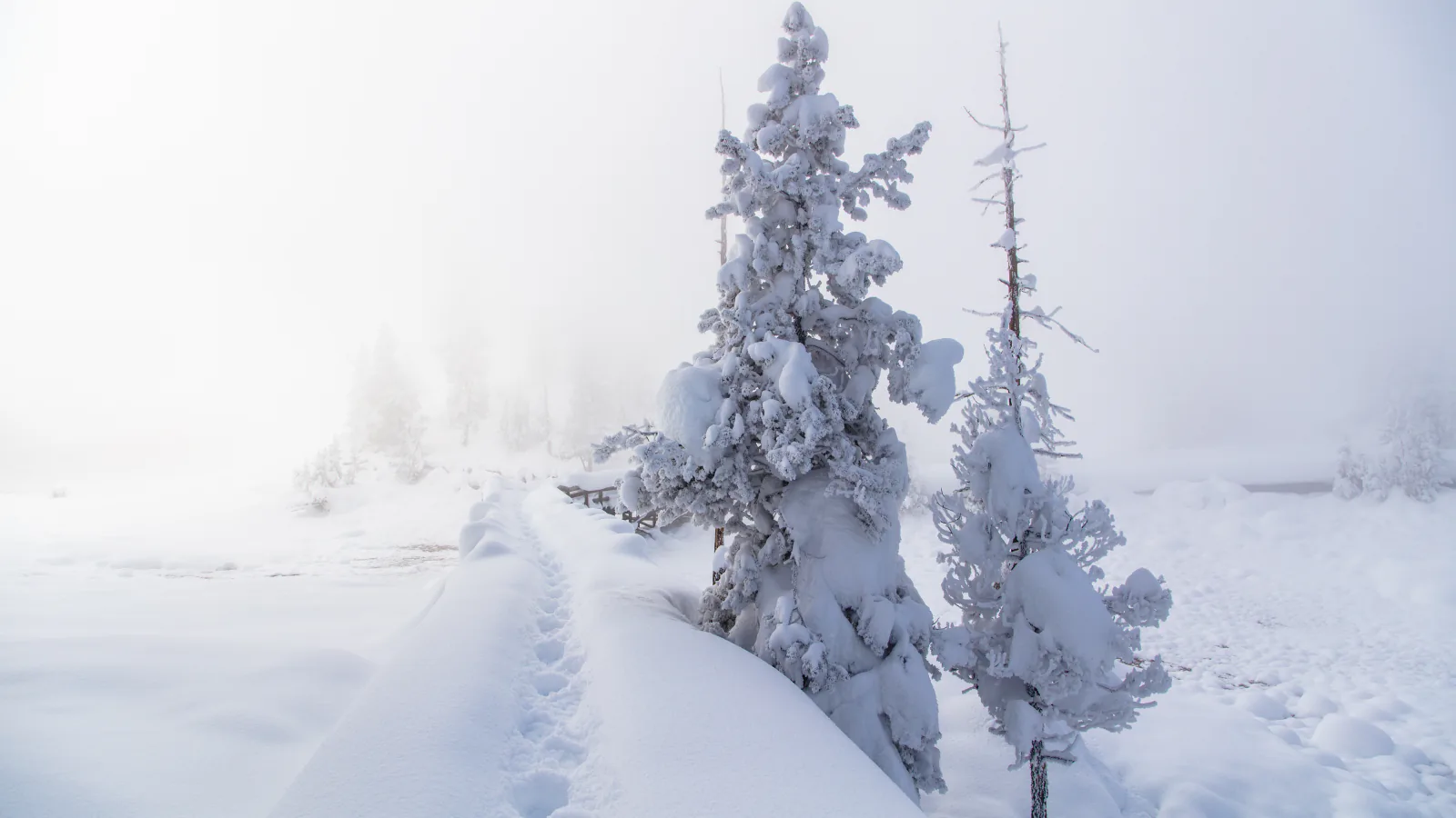
Yellowstone's hiking map is really several maps joined by long roads. A one-mile geyser-basin boardwalk, a canyon descent, a Yellowstone Lake loop, and a 10,000-foot summit may share a park name, yet they solve very different days. These 13 choices are spread around the road system so the list can help decide where to stop and how much time to reserve.
Four routes stay close to thermal features, where leaving a boardwalk can be fatal. Others cross active bear habitat, climb above treeline, or follow cold lake shores. The order follows a practical sweep from the west-side thermal country through Mammoth, Canyon, Yellowstone Lake, and the northeast; it is not a popularity ranking.
The route files supply the displayed distance and elevation gain. Yellowstone changes quickly: wildlife closures, fire, snow, washed-out tread, road access, and thermal hazards can alter a hike after this page is saved. Read the live official alerts and the park's backcountry situation report before setting out.
What changes a hiking day here
Thermal ground gives no second chance
Hot-spring crust may look solid while hiding superheated water. Stay on boardwalks and designated trails, keep children close, and never touch runoff. Pets are prohibited in thermal areas, including when carried. Leave immediately if gases make anyone feel unwell.
Every district is bear country
The NPS advises groups of three or more, daylight travel, frequent noise, and bear spray carried where each hiker can reach it. Stay 100 yards from bears, wolves, and cougars and 25 yards from bison, elk, and other wildlife. Turn back if a bear or carcass blocks the route.
Road distance belongs in the itinerary
A trail near Mammoth can be hours from one near West Thumb once traffic, wildlife jams, and construction are added. Match the hike to the district already planned for that day. No vehicle reservation is required in 2026, but an entrance pass and current road access still matter.
Snow and cold water outlast spring
Many trails lie above 7,000 feet, and passes may keep snow into late July. Streams can become deep, swift fords during runoff; Yellowstone Lake remains cold in warm weather. Carry layers and water, and use the backcountry report to judge the specific route rather than the parking-lot weather.
| Trail | Distance | Time | Difficulty | Best for |
|---|---|---|---|---|
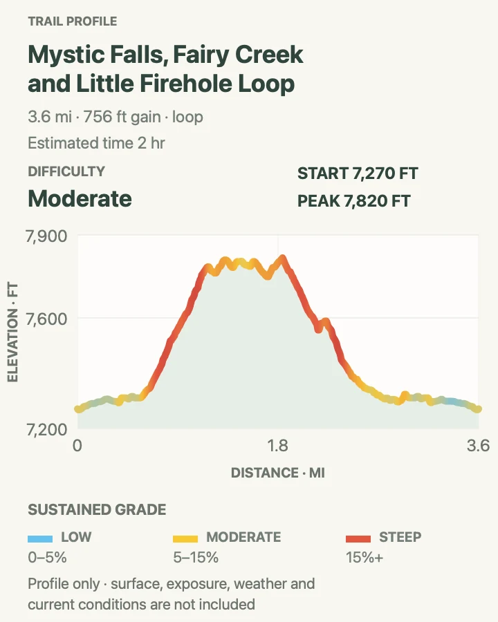
| Mystic Falls and Fairy Creek Loop | 3.7 mi | 2 hr | Moderate | A waterfall hike attached to a geyser basin |
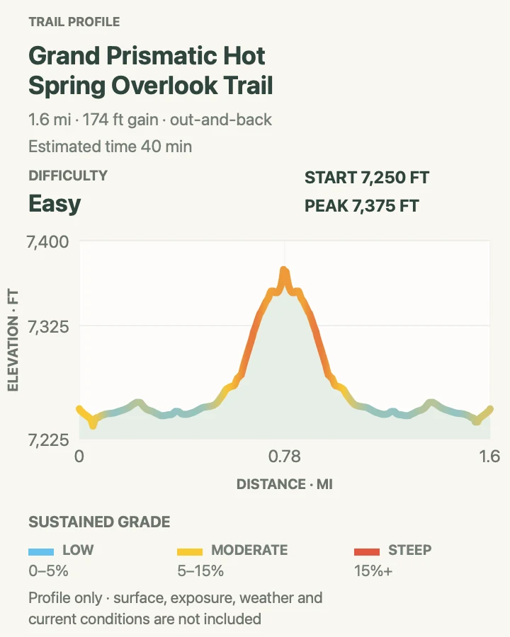
| Grand Prismatic Spring Overlook | 1.6 mi | 40 min | Easy | The clearest land-based view of Grand Prismatic |
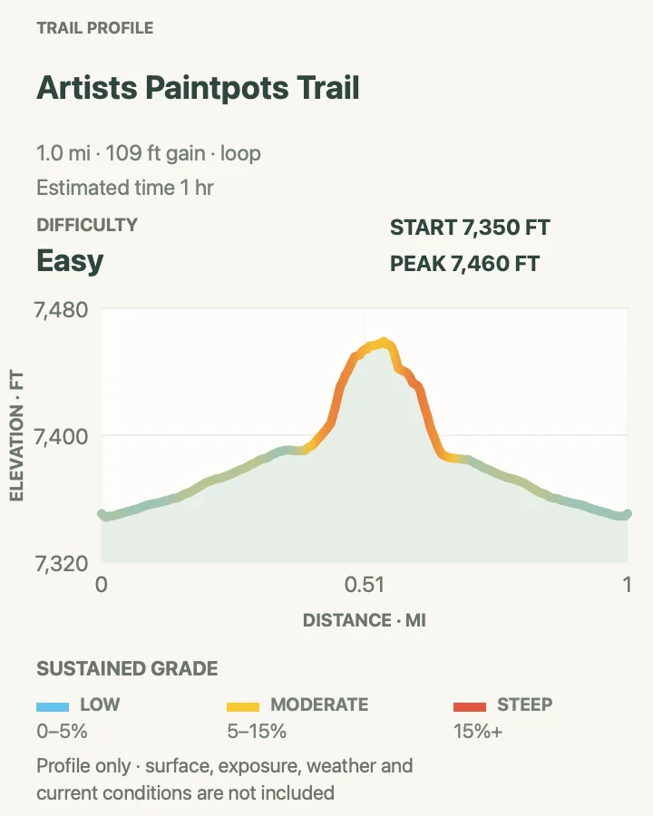
| Artists Paintpots Trail | 1 mi | 1 hr | Easy | A compact survey of colorful mudpots and springs |
| Beaver Ponds Loop | 5.7 mi | 2 hr 25 min | Moderate | A half-day wildlife-country loop near Mammoth |
| West Thumb Geyser Basin | 1 mi | 1 hr | Easy | Thermal features beside Yellowstone Lake |
| Brink of the Lower Falls and North Rim | 2 mi | 1 hr 30 min | Moderate | A close encounter with the 308-foot Lower Falls |
| Mount Washburn from Dunraven Pass | 7.1 mi | 3 hr 30 min | Moderate | A broad summit panorama from 10,219 feet |
| Natural Bridge Trail | 3.1 mi | 1 hr 30 min | Easy | An easy forest walk to a rhyolite arch |
| Mud Volcano Trail | 0.8 mi | 21 min | Easy | The park's largest concentration of restless mudpots |
| Elephant Back Mountain Trail | 3.9 mi | 1 hr 57 min | Moderate | A forested overlook above Yellowstone Lake |
| Storm Point Loop | 2.5 mi | 49 min | Easy | A short Yellowstone Lake shoreline loop |
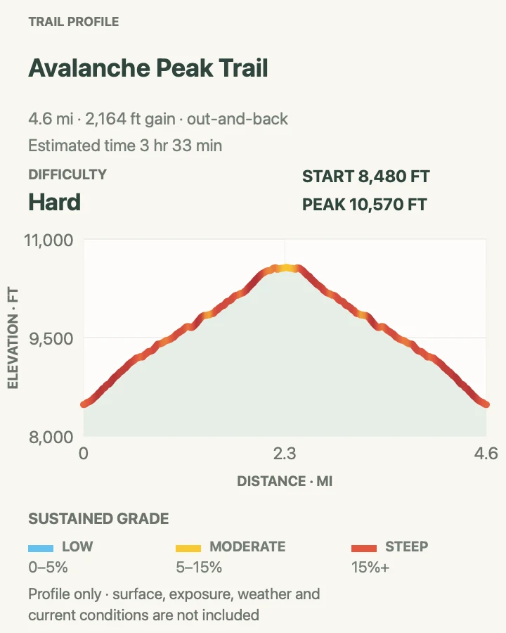
| Avalanche Peak Trail | 4.7 mi | 3 hr 33 min | Hard | A short, severe climb to an alpine summit |
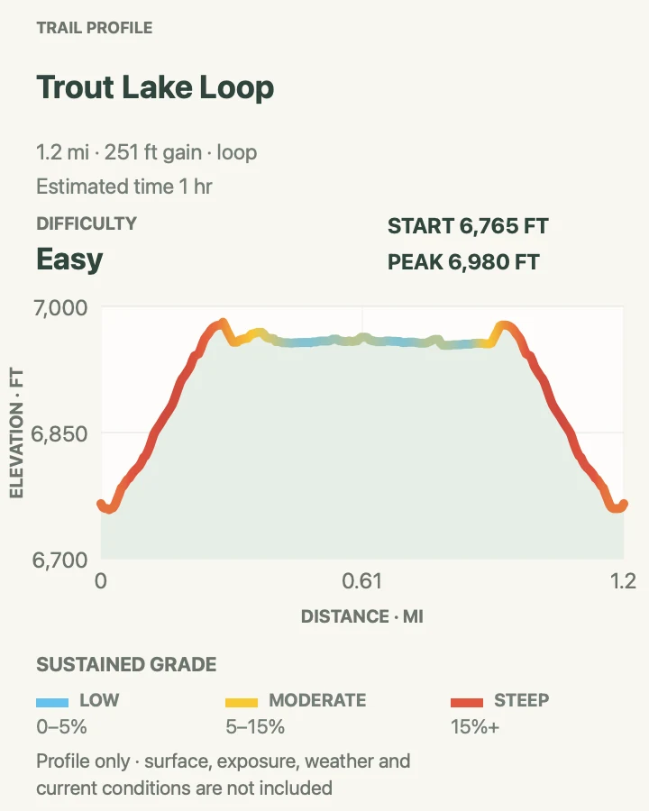
| Trout Lake Loop | 1.2 mi | 1 hr | Easy | A short northeast lake walk |
Mystic Falls and Fairy Creek Loop
- Distance
- 3.7 mi
- Elevation gain
- 760 feet
- Time
- 2 hr
- Difficulty
- Moderate
- Route type
- loop
- Parking
- Use the signed Biscuit Basin parking area and begin on the boardwalk; never park on vegetation when the lot is full.
- Best time
- Morning, before Biscuit Basin fills and while the climb above the Firehole is still cool.
- Pets
- Pets are not allowed on park trails. Trained service animals are allowed.
Mystic Falls begins among Biscuit Basin's thermal features, then leaves the boardwalk for forest beside the Little Firehole River. The falls spill down a rough wall in several steps. Continuing over the Fairy Creek side turns the outing into a loop with a higher view across the basin.
The upper loop adds steeper, drier tread and a more serious backcountry feel than the crowded opening suggests. Stay on the signed line at every thermal edge. Bear closures have affected the Old Faithful district before, so a barricade or ranger direction overrides the saved route.
What helps on this route
- Complete the basin boardwalk before the trail junction if the parking area is still quiet.
- Carry bear spray after leaving the developed boardwalk, even on a busy day.
Terrain and access: Boardwalk followed by forest trail, river edges, a moderate climb, exposed overlook tread, and a looping descent.

Grand Prismatic Spring Overlook
- Distance
- 1.6 mi
- Elevation gain
- 170 feet
- Time
- 40 min
- Difficulty
- Easy
- Route type
- out-and-back
- Parking
- Start at the Fairy Falls parking area, which fills frequently in summer; wait for a legal space.
- Best time
- A cool morning after some mist has lifted, or later in the day when parking turns over.
- Pets
- Pets are not allowed on park trails. Trained service animals are allowed.
The overlook trail follows a broad former road before climbing a short hillside above Midway Geyser Basin. From the platform, Grand Prismatic's blue center and orange microbial mats read as a whole, rather than as fragments glimpsed from the basin boardwalk.
Steam can hide the pool on cold mornings, and the small viewing area becomes crowded. Remain on the official spur and platform. The slope outside the trail is both fragile and hazardous thermal terrain, even where bare ground appears firm.
What helps on this route
- Give the overlook a few minutes; wind often clears steam in brief windows.
- Visit the Midway boardwalk separately instead of trying to descend toward the spring.
Terrain and access: Wide, nearly level approach followed by a short packed-dirt climb to a fenced overlook.

Artists Paintpots Trail
- Distance
- 1 mi
- Elevation gain
- 110 feet
- Time
- 1 hr
- Difficulty
- Easy
- Route type
- loop
- Parking
- Use the Artists Paintpots lot south of Norris and stay within the marked trail system.
- Best time
- Early or late in the day, when the small lot and narrow boardwalk are less congested.
- Pets
- Pets are not allowed on park trails. Trained service animals are allowed.
Artists Paintpots packs several kinds of hydrothermal activity into a one-mile loop. A level approach crosses lodgepole forest and wet ground; the upper loop climbs past steaming vents and thick, bubbling mudpots stained pink, gray, and cream by minerals.
The climb is short, though its uneven steps and hot exposed ground feel different from a flat boardwalk stroll. Mudpot behavior changes with water supply and season. Watch from the rail and let the feature's own pace determine the stop.
What helps on this route
- Keep loose hats and toys secured so nothing falls into a thermal feature.
- Walk the upper loop slowly; oncoming visitors have limited room to pass.
Terrain and access: Boardwalk, packed path, stairs, a short hill, and exposed thermal ground with no safe off-trail space.

Beaver Ponds Loop
- Distance
- 5.7 mi
- Elevation gain
- 900 feet
- Time
- 2 hr 25 min
- Difficulty
- Moderate
- Route type
- loop
- Parking
- Begin from the signed trailhead near Liberty Cap or behind Mammoth Hot Springs Hotel and note where the loop will finish.
- Best time
- Morning in spring through fall, with extra bear awareness in low light and thick vegetation.
- Pets
- Pets are not allowed on park trails. Trained service animals are allowed.
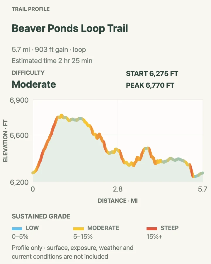
Beaver Ponds leaves the developed Mammoth terraces for sagebrush slopes, forest, ponds, and open northern-range views. Beavers may be absent; water birds, muskrats, elk, deer, pronghorn, or signs of larger wildlife often supply the interest instead.
Two trailheads make the finish easy to misread. Confirm the loop direction before climbing away from Mammoth. Bears frequent this area, and the narrow trail passes brushy water edges where loud conversation matters more than a bear bell.
What helps on this route
- Mark the chosen start on an offline map because the return may emerge elsewhere in the Mammoth complex.
- Keep the group together around ponds and blind corners.
Terrain and access: Narrow dirt and rock, switchbacks, sagebrush, forest, wooden bridges, pond margins, and several short steep grades.

West Thumb Geyser Basin
- Distance
- 1 mi
- Elevation gain
- 65 feet
- Time
- 1 hr
- Difficulty
- Easy
- Route type
- loop
- Parking
- Use the West Thumb lot; oversize vehicles should follow the posted parking layout.
- Best time
- Morning for calmer water and fewer tour groups, or evening when the basin has cooled.
- Pets
- Pets are not allowed on park trails. Trained service animals are allowed.
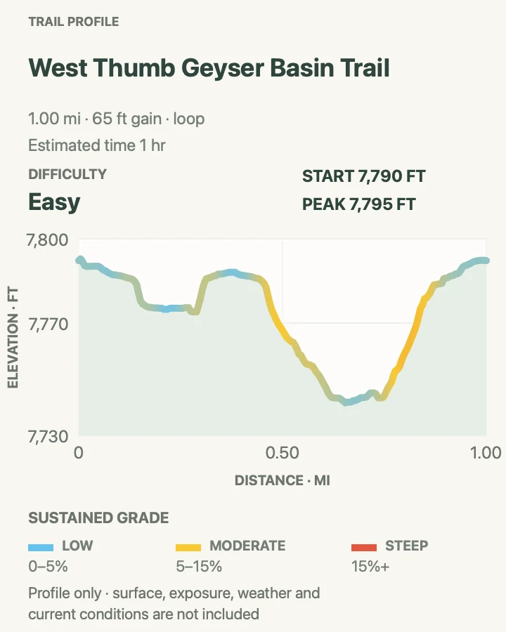
West Thumb sets hot springs and geysers against the broad edge of Yellowstone Lake. The boardwalk loop passes deep blue pools, mudpots, and lakeshore vents within a volcanic basin that later filled with water.
Wind off the lake can be sharp even under full sun. Keep everyone on the boardwalk and close to handrails where appropriate; the clear water below is scalding, and thermal crust along the shore offers no safe shortcut.
What helps on this route
- Carry a layer for the lake wind instead of judging conditions from Grant Village.
- Use the longer loop only if every boardwalk segment is open.
Terrain and access: Mostly level boardwalk and paved approaches with exposed lake wind and hazardous thermal ground on both sides.

Brink of the Lower Falls and North Rim
- Distance
- 2 mi
- Elevation gain
- 440 feet
- Time
- 1 hr 30 min
- Difficulty
- Moderate
- Route type
- out-and-back
- Parking
- Use the signed North Rim parking areas; the one-way road can make missed pullouts inconvenient.
- Best time
- Morning, before the descent becomes crowded and while canyon temperatures are mild.
- Pets
- Pets are not allowed on park trails. Trained service animals are allowed.
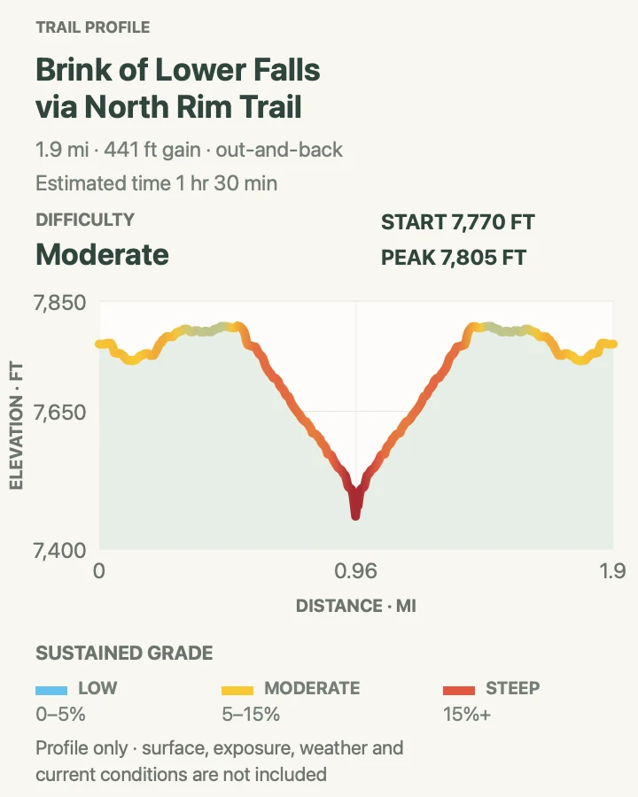
The Brink of the Lower Falls trail drops sharply to the lip where the Yellowstone River pitches into the canyon. Spray, sound, and moving water dominate the small platform. Nearby North Rim paths extend the experience toward additional canyon viewpoints.
The NPS measures the steepest section at roughly 600 feet of descent in 0.4 mile. Every step down must be climbed on the return. People with heart, lung, knee, or balance concerns can use the rim overlooks for a strong view without committing to the brink.
What helps on this route
- Let ascending hikers keep their rhythm on the steep path.
- Keep children close on the platform and never lean beyond barriers for a photograph.
Terrain and access: Paved but extremely steep switchbacks and steps, a confined brink platform, and rolling North Rim connectors.

Mount Washburn from Dunraven Pass
- Distance
- 7.1 mi
- Elevation gain
- 1,380 feet
- Time
- 3 hr 30 min
- Difficulty
- Moderate
- Route type
- out-and-back
- Parking
- Use the Dunraven Pass trailhead; the small lot fills early on peak summer days.
- Best time
- A clear summer morning, avoiding September and October when grizzly activity is high along this route.
- Pets
- Pets are not allowed on park trails. Trained service animals are allowed.
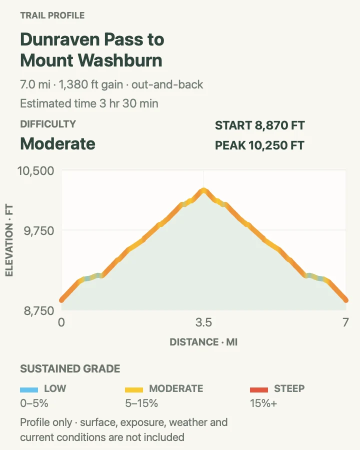
From Dunraven Pass, the trail traverses flowered slopes and climbs steadily to Mount Washburn's fire lookout. On a clear day the summit view reaches across the Yellowstone caldera, canyon country, lake, and distant ranges.
There is no water along the trail and little protection above treeline. Lightning, wind, sun, and bears are the main concerns. The park specifically discourages this hike in September and October because grizzlies frequent the area then.
What helps on this route
- Carry all drinking water from the trailhead and pack a wind layer.
- Turn around before thunder reaches the open ridge; the lookout is not a storm plan.
Terrain and access: Steady alpine climb, open sidehill tread, exposed ridge travel, and a long descent at high elevation.

Natural Bridge Trail
- Distance
- 3.1 mi
- Elevation gain
- 300 feet
- Time
- 1 hr 30 min
- Difficulty
- Easy
- Route type
- out-and-back
- Parking
- Walk from Bridge Bay Marina using the signed trail and service-road connection.
- Best time
- After the early-summer bear closure has lifted and before the marina area becomes busy.
- Pets
- Pets are not allowed on park trails. Trained service animals are allowed.
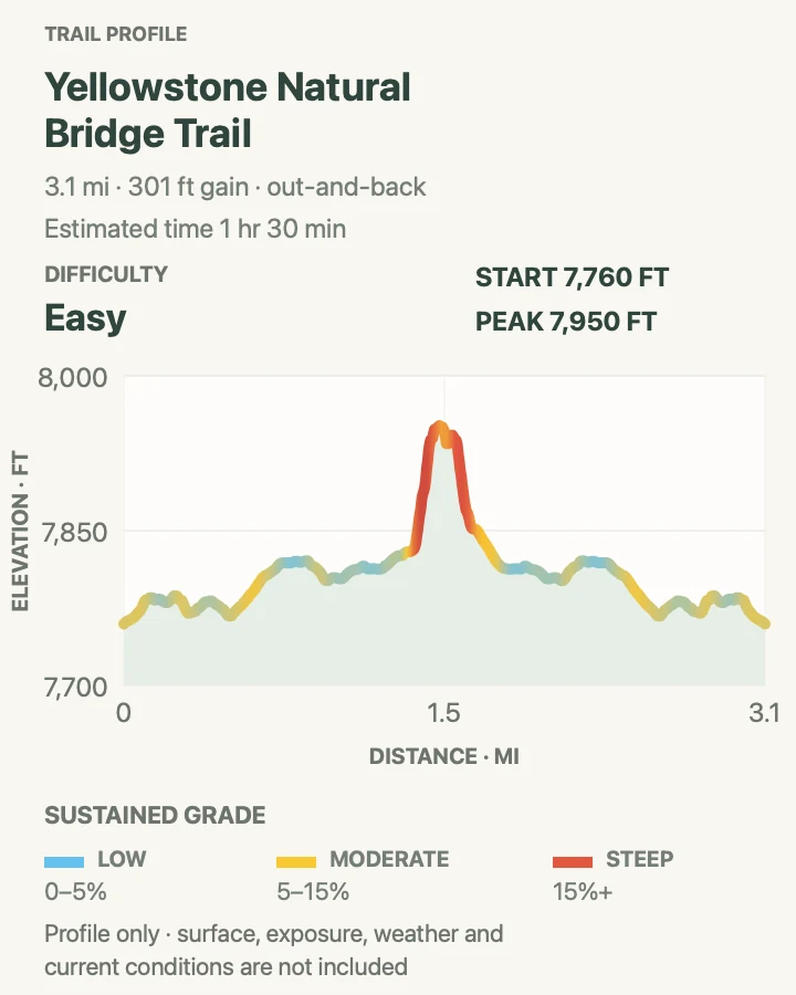
Bridge Creek cut Yellowstone's Natural Bridge through a 51-foot rhyolite cliff. The approach mixes forest trail and an old service road before reaching the exhibit and a short switchback toward the formation.
The top of the bridge is closed to protect the feature. Early in summer, the entire trail commonly closes while bears feed on spawning trout. Confirm the opening date, stay below barriers, and expect wet rock near the creek.
What helps on this route
- Ask at Fishing Bridge when early-season access is uncertain.
- Keep off the top of the arch even if old footprints appear beyond the closure.
Terrain and access: Semi-paved forest approach, service road, short steep switchbacks, creek edges, and potentially slick rock.

Mud Volcano Trail
- Distance
- 0.8 mi
- Elevation gain
- 120 feet
- Time
- 21 min
- Difficulty
- Easy
- Route type
- loop
- Parking
- Use the Mud Volcano lot south of Hayden Valley and remain inside the marked boardwalk system.
- Best time
- Early morning or evening, when traffic through Hayden Valley is lighter.
- Pets
- Pets are not allowed on park trails. Trained service animals are allowed.
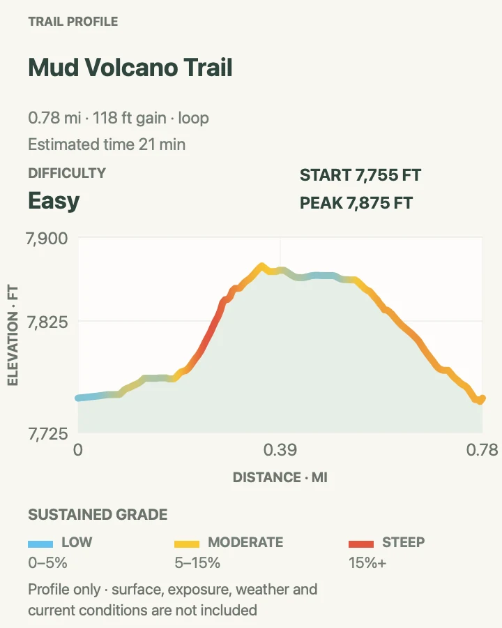
Mud Volcano's short loop passes steaming vents, acidic pools, and mudpots that thump and gurgle as gas escapes through clay. The boardwalk climbs enough to separate this stop from a level roadside viewing platform.
Hydrogen sulfide and other gases can collect in thermal basins. Anyone who feels ill should leave promptly. Keep hands away from runoff and children within reach; the dull-colored water is hot enough to cause severe burns.
What helps on this route
- Walk uphill at a measured pace because heat and sulfur gases can make exertion uncomfortable.
- Expect bison near Hayden Valley roads and keep the required 25-yard distance.
Terrain and access: Boardwalk and paved path with a sustained short hill, stairs, steam, and unstable thermal ground beside the route.

Elephant Back Mountain Trail
- Distance
- 3.9 mi
- Elevation gain
- 810 feet
- Time
- 1 hr 57 min
- Difficulty
- Moderate
- Route type
- loop
- Parking
- Use the pullout about one mile south of Fishing Bridge Junction and keep the vehicle fully off the road.
- Best time
- A clear morning after the trail is reported open and dry enough for the forest climb.
- Pets
- Pets are not allowed on park trails. Trained service animals are allowed.
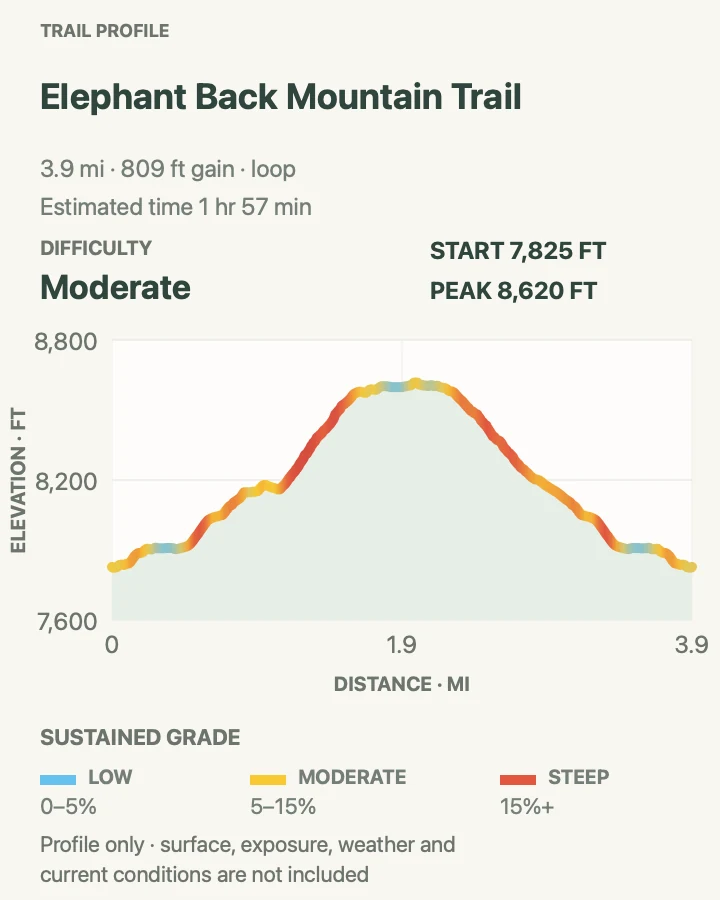
Elephant Back Mountain climbs through lodgepole forest to an overlook above Yellowstone Lake. The trail splits into a loop after the main ascent begins; both branches meet again near the viewpoint.
The trees hide the lake for much of the approach, so the overlook arrives all at once. Bears use the forest, and the small trailhead provides little warning about conditions higher up. Make noise, carry spray, and check that the route remains open.
What helps on this route
- Choose a loop direction at the signed fork and remember it for the descent.
- Do not stop making bear noise just because other cars are present at the pullout.
Terrain and access: Dense forest, a sustained 800-foot climb, roots and rock, a lollipop loop, and one open lake viewpoint.

Storm Point Loop
- Distance
- 2.5 mi
- Elevation gain
- 50 feet
- Time
- 49 min
- Difficulty
- Easy
- Route type
- loop
- Parking
- Use the Indian Pond pullout east of Fishing Bridge; verify the trail is open before leaving the car.
- Best time
- A calm morning after seasonal bear closures have lifted.
- Pets
- Pets are not allowed on park trails. Trained service animals are allowed.
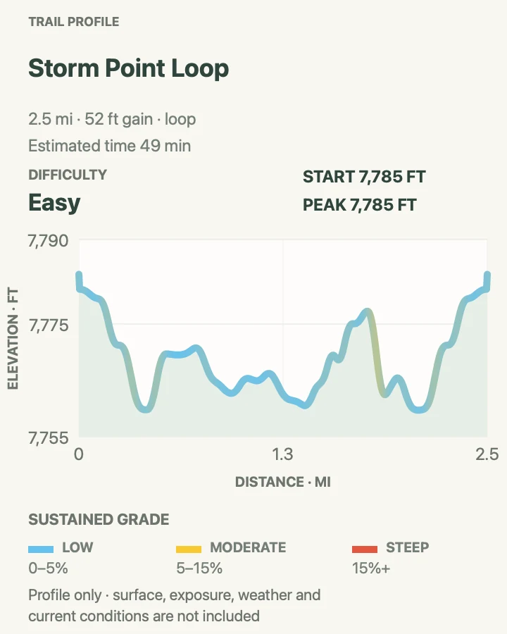
Storm Point crosses open meadow near Indian Pond, slips through lodgepole forest, and reaches a wind-polished rock point on Yellowstone Lake. Marmots inhabit the rocks, while the return follows shore and forest to close the loop.
Bear activity often closes the trail in late spring and early summer. A separate beach area west of the route is also closed to protect plants. Stay on the established loop and back away if wildlife occupies the point or approach.
What helps on this route
- Confirm closure status at Fishing Bridge or in the current situation report.
- Pack a warm layer; the point can be windy when the meadow is still.
Terrain and access: Open meadow, forest floor, flat lakeshore tread, exposed rock, and generally gentle grades.

Avalanche Peak Trail
- Distance
- 4.7 mi
- Elevation gain
- 2,160 feet
- Time
- 3 hr 33 min
- Difficulty
- Hard
- Route type
- out-and-back
- Parking
- Use the signed pullout west of the East Entrance and cross the road carefully to the trail.
- Best time
- A clear midsummer morning after snow has left the ridge and before afternoon lightning.
- Pets
- Pets are not allowed on park trails. Trained service animals are allowed.
Avalanche Peak gains about 2,100 feet in a little over two miles. Forest gives way to a large bowl, talus slopes, and a narrow summit ridge with views toward remote peaks and Yellowstone Lake.
The ratio of gain to mileage makes this one of the hardest outings in the guide. Snow often lingers into July, and the exposed ridge is a dangerous place for lightning or high wind. The NPS does not recommend the route for people with heart or respiratory problems.
What helps on this route
- Carry rain gear, hat, and gloves even when the East Entrance road is warm.
- Cross the narrow ridge only when wind, footing, and visibility are comfortably within the group's ability.
Terrain and access: Very steep forest climb, open bowl, loose talus, narrow ridgeline, possible snow, and roughly 2,100 feet of gain.

Trout Lake Loop
- Distance
- 1.2 mi
- Elevation gain
- 250 feet
- Time
- 1 hr
- Difficulty
- Easy
- Route type
- loop
- Parking
- Use the small pullout south of Pebble Creek Campground on the Northeast Entrance Road.
- Best time
- Morning or evening for softer light, while avoiding dawn and dusk when bears are most active.
- Pets
- Pets are not allowed on park trails. Trained service animals are allowed.
Trout Lake sits above the road behind a brief 150-foot climb through Douglas-fir. Once at the water, the trail makes a small loop around wet meadow and shore with views toward the rounded northeast hills.
The modest distance does not remove wildlife concerns. Bears use this country, and the narrow shore can put hikers close to animals before either notices. Keep the group together, carry spray, and give otters, waterfowl, and larger animals room.
What helps on this route
- Wait for another legal space if the small pullout is full.
- Step back from the shore rather than crowding wildlife for a photograph.
Terrain and access: Short forest climb, narrow lakeshore tread, damp meadow edges, a small loop, and gentle grades after the approach.

Official planning sources
Trail access and safety details were checked against these National Park Service pages. The maps and profiles use the reviewed route geometry stored with this guide.
Map data © OpenStreetMap contributors. Trail geometry and planning details include National Park Service public information.