7 Best Hikes in Grand Canyon National Park
Seven Grand Canyon hikes chosen by purpose: South Rim walking, short descents, a demanding Bright Angel day, and three carefully framed overnight routes.
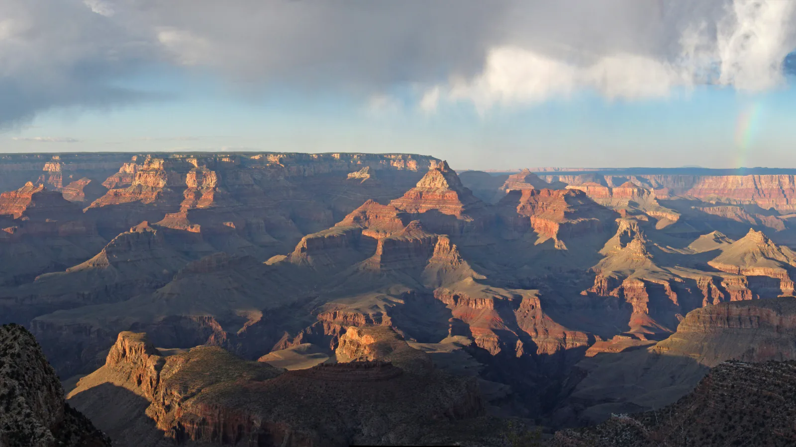
A Grand Canyon trail list needs an honest brake pedal. Walking downhill is easy enough to fool people, the climb out can take twice as long, and the inner canyon is often about 30°F hotter than the rims. A river view is not a sensible turnaround simply because it appears on a map.
These seven routes begin with two flexible rim walks, then step down through Ooh Aah Point and Havasupai Gardens. The final two are here because they are superb trips, but they belong in an overnight itinerary with confirmed lodging or a backcountry permit. The National Park Service does not recommend hiking from the rim to the river and back in one day.
This guide was checked on August 29, 2026. The South Kaibab, Bright Angel, and full North Kaibab corridors were open that day. The North Rim had limited services after the Dragon Bravo Fire, no potable water at the rim or North Kaibab trailhead, and several familiar North Rim trails remained closed. A lower North Kaibab closure is scheduled to begin after October 15, ending traditional rim-to-rim travel for the balance of 2026. Recheck the park's trail-status page before leaving home.
What changes a hiking day here
Treat the rim and river as different climates
South Rim mornings can feel comfortable while Phantom Ranch is moving toward dangerous heat. In summer, arrange the day so the climb is not happening between 10 a.m. and 4 p.m. Eat as you walk, carry more water than a rim stroll requires, and turn around early when the pace slips.
Check water every morning
South Kaibab has no water below its trailhead. Bright Angel and North Kaibab taps can shut without warning after a pipeline break. On August 29, water was on at Havasupai Gardens and the two Bright Angel resthouses, while the North Rim, North Kaibab trailhead, and Supai Tunnel taps were off. Carry treatment even when a status page says a lower tap is running.
Use the buses as part of the route
Private vehicles cannot drive to the South Kaibab trailhead. The Kaibab Rim Route and early Hikers' Express serve it, and the Hermit Road bus lets walkers shorten a rim outing. Hermit Road is closed to private vehicles from March through November. Check the last bus before committing to an evening walk.
Separate day hiking from camping
Ordinary noncommercial day hikes do not need a backcountry permit. Sleeping below the rim does. Corridor campsites are reserved through Recreation.gov, and Phantom Ranch lodging is a separate reservation. Do not start a river or rim-to-rim trip with a plan to improvise a campsite.
Leave pets above the rim
Leashed pets may use South Rim trails above the edge, campgrounds, and developed areas. They are prohibited on inner-canyon trails and cannot ride park buses. That makes the rim entries below the only realistic choices for a visitor traveling with a dog.
| Trail | Distance | Time | Difficulty | Best for |
|---|---|---|---|---|
| Greenway to the Rim Trail | 4.8 miles out and back | 2 hr | Moderate | A first walk, a family outing, bicycles, and a low-commitment route near visitor services |
| Maricopa Point on the Rim Trail | 4.4 miles out and back | 2 hr | Moderate | Historic Hermit Road, an uncrowded-feeling overlook, and a customizable rim walk |
| South Kaibab Trail to Ooh Aah Point | About 1.8 miles out and back | 1 hr 20 min | Moderate | A short first descent with open canyon views almost from the first switchback |
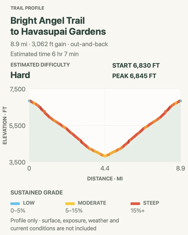
| Bright Angel Trail to Havasupai Gardens | About 9 miles out and back | 6 hr 7 min | Hard | A full-day corridor hike with resthouses, some shade, and a clear turnaround |
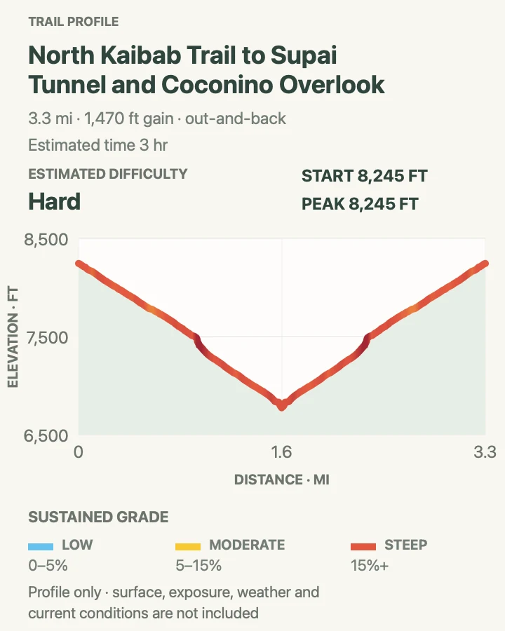
| North Kaibab Trail to Coconino Overlook and Supai Tunnel | About 4 miles out and back to Supai Tunnel | 3 hr | Hard | The North Rim's forest-to-canyon transition and a demanding half-day descent |
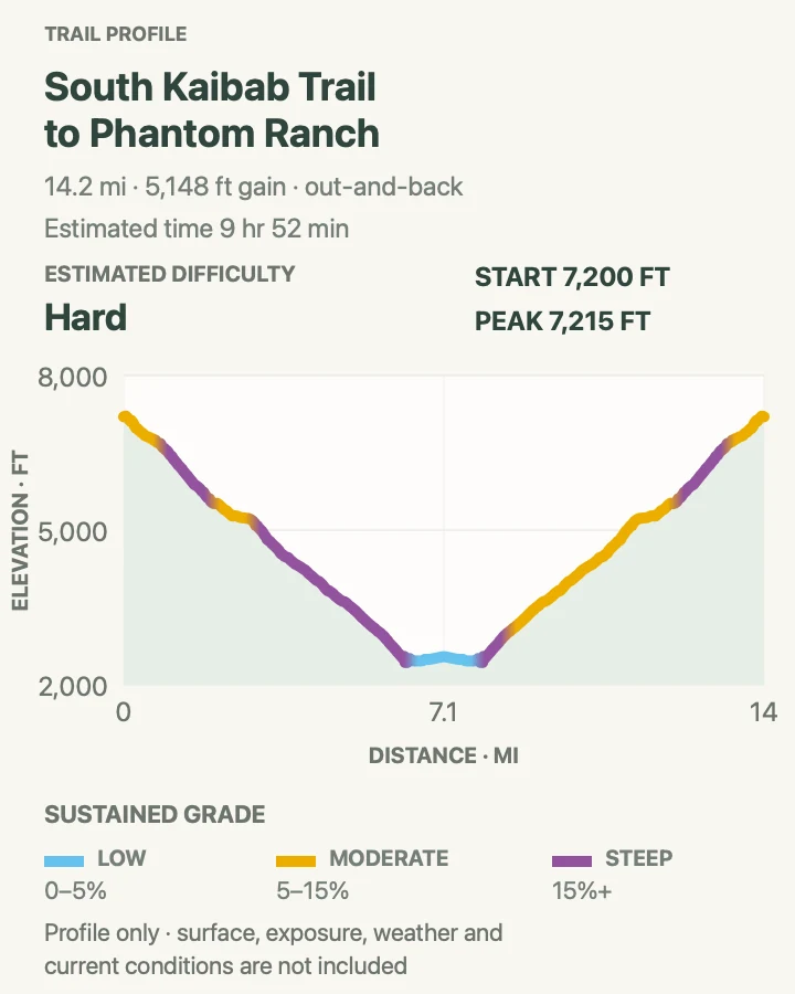
| South Kaibab Trail to Phantom Ranch (Overnight) | About 7 miles one way; the reviewed profile shows the 14.2-mile out-and-back trace | 9 hr 52 min | Hard | A first corridor backpack to the Colorado River and Phantom Ranch |
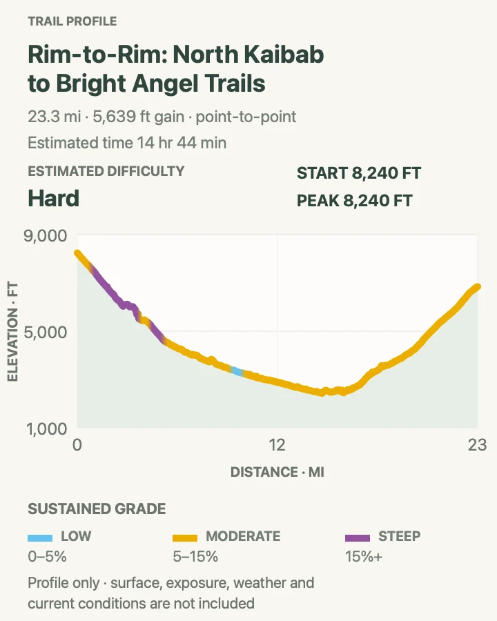
| Rim-to-Rim via North Kaibab and Bright Angel (Advanced Overnight) | About 23.3 miles point to point | 14 hr 44 min | Hard | Experienced backpackers with permits, transport, and a conservative inner-canyon itinerary |
Greenway to the Rim Trail
- Distance
- 4.8 miles out and back
- Elevation gain
- 250 feet
- Time
- 2 hr
- Difficulty
- Moderate
- Route type
- out-and-back
- Parking
- Use the Grand Canyon Visitor Center lots and join the signed paved Greenway near the shuttle plaza.
- Best time
- Morning or late afternoon, when the paved sections are cooler and rim light is softer.
- Pets
- Leashed pets are allowed on South Rim trails above the canyon rim, but not on park buses.
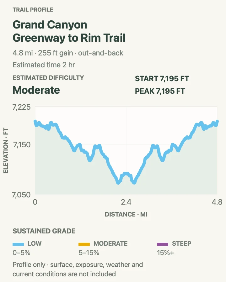
This route uses the broad Greenway system to connect the visitor-center area with rim viewpoints and the South Kaibab side of the village. It is a practical first outing: navigation is simple, services are close, and the path can be shortened at several junctions. The map's 4.8-mile line is a full out-and-back rather than a required minimum.
The walking is gentle by Grand Canyon standards, though 7,000 feet of elevation and full sun still matter. Stay on the signed path near roads and bike traffic. If anyone in the group feels the altitude, turn the outing into a short viewpoint walk instead of chasing the mileage.
What helps on this route
- Use this walk to learn the shuttle stops before a below-rim day.
- Bicycles and e-bikes share designated Greenway sections; walk predictably and keep to the right.
Terrain and access: Mostly paved shared-use path, short grades, road crossings, exposed rim weather, high elevation, occasional bicycle traffic, and easy access to developed services.

Maricopa Point on the Rim Trail
- Distance
- 4.4 miles out and back
- Elevation gain
- 440 feet
- Time
- 2 hr
- Difficulty
- Moderate
- Route type
- out-and-back
- Parking
- Park in Grand Canyon Village and walk or ride the Hermit Road shuttle to a convenient stop; private vehicles are barred from Hermit Road March through November.
- Best time
- A clear morning for long views or late afternoon with enough margin to catch the return bus.
- Pets
- Leashed pets are allowed above the rim but cannot board the shuttle, so pet owners need an out-and-back plan.
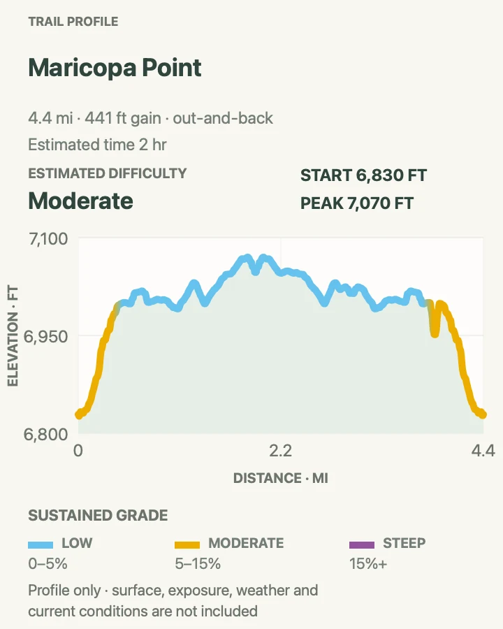
Maricopa Point sits west of the village where the Rim Trail follows Hermit Road. The overlook reveals the Bright Angel corridor and the old Orphan Lode mine area, while the approach moves between paved path and narrower dirt tread. Walking from the transfer area gives the full route; using the red bus can trim either end.
The exposure is visual rather than technical, but there are unfenced stretches and steep ground beyond the trail. Keep children close at overlooks. Carry water from the village because the western Rim Trail has long gaps without a reliable refill.
What helps on this route
- Photograph the bus timetable before starting; outbound and return stops are not identical.
- Continue another half mile to Powell Point only if daylight and the return plan still work.
Terrain and access: Paved and dirt rim path, moderate rolling grades, exposed overlooks, high elevation, little shade, shuttle-linked road corridor, and no descent into the canyon.

South Kaibab Trail to Ooh Aah Point
- Distance
- About 1.8 miles out and back
- Elevation gain
- 630 feet
- Time
- 1 hr 20 min
- Difficulty
- Moderate
- Route type
- out-and-back
- Parking
- Park at the visitor center or Backcountry Information Center and take the Kaibab Rim bus or Hikers' Express; private cars cannot reach the trailhead.
- Best time
- At sunrise or very early morning, particularly from late spring through early fall.
- Pets
- Pets are prohibited below the rim.
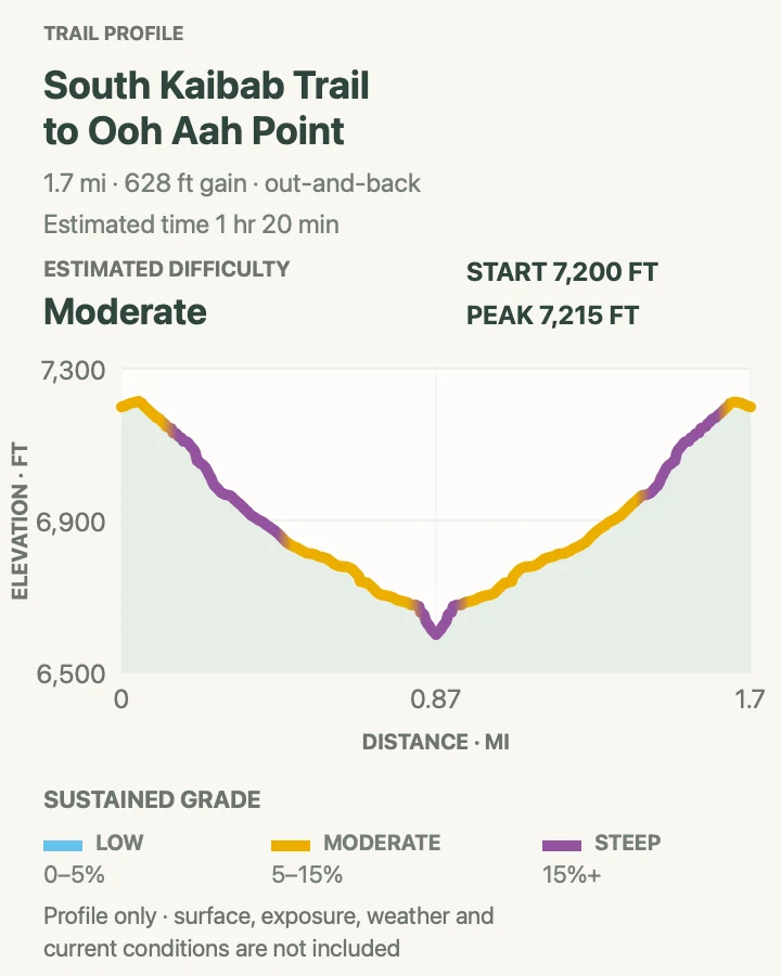
South Kaibab drops directly from the rim with almost no warm-up. Ooh Aah Point arrives before Cedar Ridge and gives a broad view into the inner canyon without committing to a half-day return. The ledges are maintained, but loose grit and mule traffic ask for attention.
There is no water and almost no shade below the trailhead. The ascent gains roughly 630 feet in less than a mile, which is where the route earns its moderate rating. If the climb to Ooh Aah already feels taxing, the right decision is to enjoy the point and go back.
What helps on this route
- Give mules the uphill side of the trail and follow the wrangler's directions.
- Carry water from the rim even for this short route; a trailhead tap is not a supply once you have descended.
Terrain and access: Steep switchbacks, packed dirt, stone steps, loose grit, open exposure, mule traffic, almost no shade, and no water below the trailhead.

Bright Angel Trail to Havasupai Gardens
- Distance
- About 9 miles out and back
- Elevation gain
- 3,060 feet
- Time
- 6 hr 7 min
- Difficulty
- Hard
- Route type
- out-and-back
- Parking
- Park at the Backcountry Information Center lot or use the village shuttle, then walk to the trailhead just west of Bright Angel Lodge.
- Best time
- A cool-season day or a pre-dawn summer start for very fit, heat-ready hikers.
- Pets
- Pets are prohibited below the rim.
Bright Angel follows a fault through the rim cliffs, passes the 1.5-Mile and 3-Mile resthouses, then eases onto the shaded creek bench at Havasupai Gardens. The campground lies roughly 4.8 miles below the rim. Its water, toilets, emergency phone, and cottonwoods make it a far better turnaround than an arbitrary spot on an exposed slope.
The recorded map traces the one-way descent, while the distance above includes the return to the rim. Expect roughly 3,000 feet of climbing on the way back. The park says not to continue past Havasupai Gardens on a summer day hike. Water was running at the gardens and both resthouses when this guide was checked, but pipeline status can change the same day.
What helps on this route
- Set a turnaround time before descending and obey it even if the morning pace feels easy.
- Carry treatment and enough water to climb out without every tap; never make a seasonal pipe your only plan.
Terrain and access: Maintained corridor trail, long switchbacks, stone steps, mule traffic, patches of shade, exposed lower slopes, roughly 3,000 feet of return climbing, and seasonal water infrastructure.

North Kaibab Trail to Coconino Overlook and Supai Tunnel
- Distance
- About 4 miles out and back to Supai Tunnel
- Elevation gain
- 1,470 feet
- Time
- 3 hr
- Difficulty
- Hard
- Route type
- out-and-back
- Parking
- Use the North Kaibab trailhead lot after confirming State Route 67, the North Rim entrance, and the trailhead are open.
- Best time
- Early in the short North Rim season, with enough carried water for the entire outing.
- Pets
- Pets are prohibited below the rim.
North Kaibab is the only maintained trail entering the canyon from the North Rim. Coconino Overlook makes a 1.5-mile round trip; continuing to Supai Tunnel brings the day to roughly four miles and about 1,450 feet of return climbing. The colder, forested trailhead quickly gives way to open switchbacks and limestone walls.
The 2026 season is unusual. North Rim day use and limited backcountry access have reopened, but nearby trails and services remain affected by the Dragon Bravo Fire. No potable water was available at the North Rim, North Kaibab trailhead, or Supai Tunnel on August 29. Bring the full supply from outside the park and confirm the road and trail status before the long drive from Jacob Lake.
What helps on this route
- Coconino Overlook is a sound turnaround when the climb, heat, or water use is running ahead of plan.
- Do not extend toward Roaring Springs casually; the park calls that a full, extremely strenuous day.
Terrain and access: Steep maintained corridor trail, forested rim, exposed switchbacks, mule traffic, about 1,450 feet of climbing, limited 2026 services, and no potable water at the trailhead or Supai Tunnel.

South Kaibab Trail to Phantom Ranch (Overnight)
- Distance
- About 7 miles one way; the reviewed profile shows the 14.2-mile out-and-back trace
- Elevation gain
- 5,150 feet
- Time
- 9 hr 52 min
- Difficulty
- Hard
- Route type
- out-and-back
- Parking
- Leave a vehicle near the planned exit, then take the early Hikers' Express to South Kaibab Trailhead.
- Best time
- A cool-weather overnight with a confirmed Bright Angel Campground permit or Phantom Ranch reservation.
- Pets
- Pets are prohibited below the rim.
South Kaibab reaches the river quickly by Grand Canyon standards: about 6.3 miles to the Colorado, then another short walk across the Black Bridge to Bright Angel Campground and Phantom Ranch. The trail stays open to the view, passing Cedar Ridge, Skeleton Point, and the Tipoff before the Inner Gorge. That openness also means relentless sun and no water between the trailhead and the river.
Use the map to understand the descent, not as a recommendation to return the same day. The park advises against a rim-to-river-and-back day hike. Reserve a legal overnight, descend early, then climb out Bright Angel rather than South Kaibab when conditions and trail notices permit; Bright Angel is longer but offers some shade and seasonal water.
What helps on this route
- Carry enough water to reach Phantom Ranch even if the trailhead tap is off.
- Keep food and scented items in the campground storage can; rodents can ruin an overnight plan fast.
Terrain and access: Sustained exposed descent, roughly 4,800 feet to the river, stone steps, loose dirt, mule traffic, no water below the trailhead, suspension bridge, and extreme inner-canyon heat.

Rim-to-Rim via North Kaibab and Bright Angel (Advanced Overnight)
- Distance
- About 23.3 miles point to point
- Elevation gain
- 5,640 feet
- Time
- 14 hr 44 min
- Difficulty
- Hard
- Route type
- point-to-point
- Parking
- Arrange a commercial rim-to-rim shuttle or two vehicles before the trip; driving between rims takes about 4.5 hours each way.
- Best time
- A permitted multi-day window before the scheduled October 16, 2026 corridor interruption, after checking heat, water, road, and fire notices.
- Pets
- Pets are prohibited below the rim.
The classic crossing descends North Kaibab through Roaring Springs Canyon, follows Bright Angel Creek past Cottonwood and Phantom Ranch, crosses the Colorado, and climbs Bright Angel to the South Rim. It links nearly 6,000 feet of descent with more than 4,000 feet of ascent. The distance alone does not explain the heat, sleep, food, water, and transport decisions packed into the route.
For 2026, the timing window is narrow. The full North Kaibab corridor was open on August 29, but the North Rim had no potable water and was operating with limited services. A closure between Redwall Bridge and Cottonwood begins late October 15, so traditional rim-to-rim travel will not be possible from October 16. Reserve camps first, then transportation and lodging; do not reverse that order or rely on a same-day crossing as a fallback.
What helps on this route
- Plan multiple nights for a first crossing; Cottonwood and Bright Angel campgrounds break the distance into manageable pieces.
- Carry water treatment and verify every corridor tap immediately before departure.
Terrain and access: Long point-to-point corridor, nearly 6,000 feet of descent and 4,400 feet of ascent, sustained switchbacks, narrow exposed sections, creeks and bridges, mule traffic, extreme temperature change, and remote camps.

Official planning sources
Trail access and safety details were checked against these National Park Service pages. The maps and profiles use the reviewed route geometry stored with this guide.
- NPS: Current Grand Canyon trail status and corridor water
- NPS: Grand Canyon day hiking
- NPS: 2026 North Rim access and services
- NPS: Hiking questions and corridor advice
- NPS: Corridor campgrounds and facilities
- NPS: Backcountry permit reservations
- NPS: South Rim shuttle routes for 2026
- NPS: Rim Trail distances and services
- NPS: Grand Canyon pet rules
- NPS: Summer hiking safety
Map data © OpenStreetMap contributors. Trail geometry and planning details include National Park Service public information.