9 Best Hikes and Routes in Wrangell-St. Elias
Nine mapped hikes and wilderness routes across the McCarthy, Kennecott, Nabesna Road, and Chitistone areas, with current access notes, terrain maps, and measured elevation profiles.
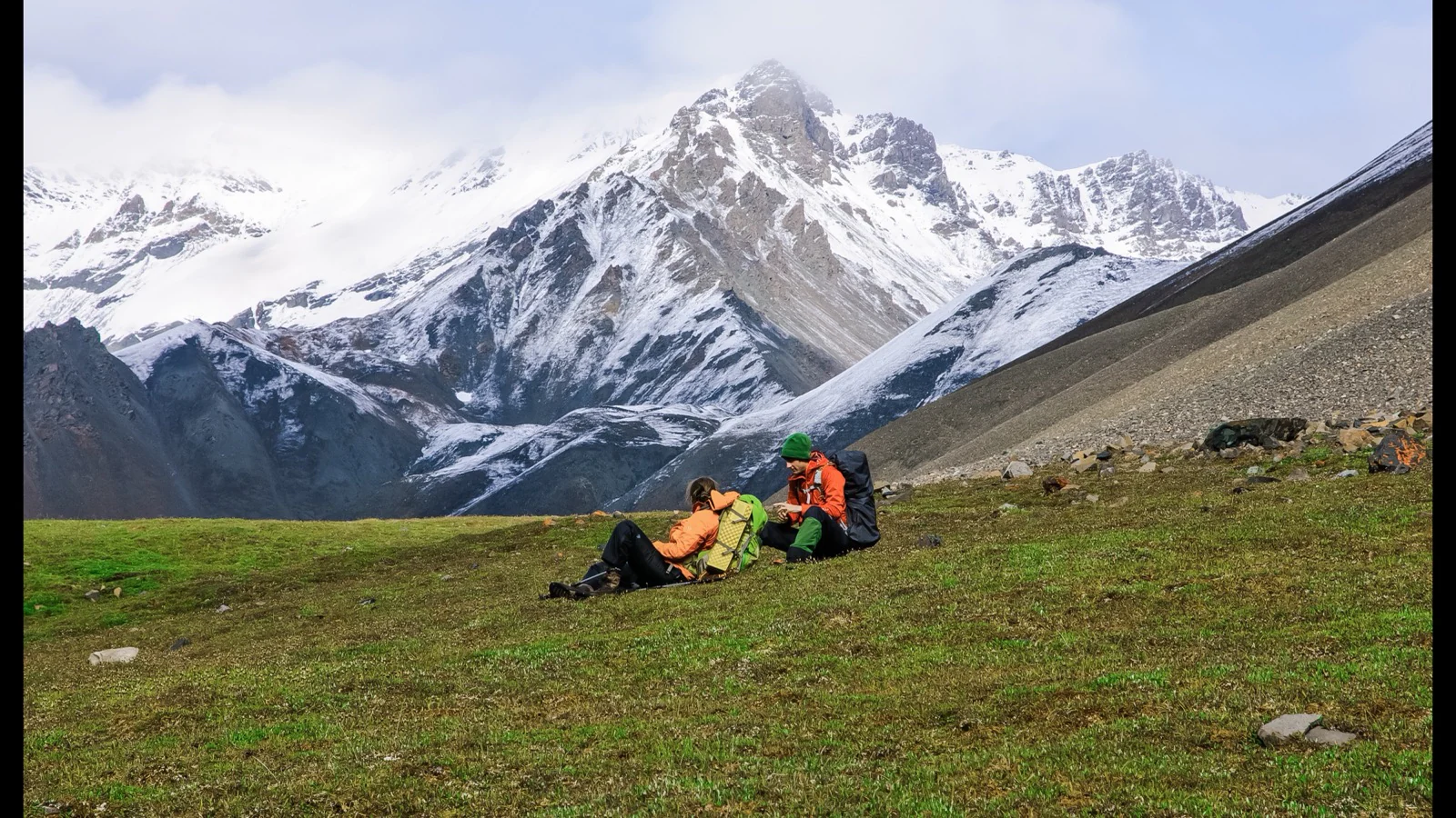
Wrangell-St. Elias is too large and too lightly developed for one trail system to define it. The road-accessible hikes cluster along the 60-mile McCarthy Road, around McCarthy and Kennecott, and along the 42-mile Nabesna Road. Soda Lake and the Goat Trail are different undertakings: remote, multi-day routes that require backcountry judgment and, for the Goat Trail, chartered flights.
These nine entries are organized by access area and trip commitment. Short forest loops and mine walks come first within each road corridor; the remote routes come last. Distances on the cards follow the preserved geometry used for the terrain maps and elevation profiles, so they may differ from rounded NPS handout distances or from a recently signed reroute.
Official trail and access information was checked on August 30, 2026. NPS restored Root Glacier access on August 3 with a new signed route that avoids an active landslide; the former access remains closed. Road washouts, creek levels, glacier margins, wildfire, and air-taxi conditions can change faster than an article. Check the live alert and weather panels, then confirm remote plans with park staff before leaving reliable communication.
Live park weather
Wrangell-St. Elias National Park
Kennecott Visitor Center
Loading the latest conditions and alerts…
What changes a hiking day here
Treat McCarthy and Nabesna as separate hiking bases
The two road corridors do not connect through the park. McCarthy Road reaches the southwest side and the Kennecott area; Nabesna Road enters the north side from Slana. Driving between them requires returning to the highway system and takes most of a day. Group the Crystalline Hills, Kennicott, Root Glacier, and Bonanza hikes together, then give the Nabesna Road routes their own days.
Both park roads can stop a trip before the trailhead
McCarthy and Nabesna are long gravel roads with limited services, weak cell coverage, changing surfaces, and private land beside the right-of-way. NPS recommends a full-size spare and an adequate jack. High clearance may be necessary after rain or at Nabesna stream crossings, and many rental agreements prohibit these roads. Check current conditions and carry enough fuel for the return.
Use the signed 2026 Root Glacier reroute
The old Root Glacier access near the Erie Mine trail remains closed because of landslide and rockfall danger. The signed replacement begins about 1.8 miles along Erie Mine Trail, just beyond the Amazon Creek footbridge, then descends roughly 0.6 mile over brush, talus, mud, and glacial debris. Follow current signs and barriers even when a saved map or older handout shows another line.
Creek crossings decide several Nabesna trips
Caribou Creek, Skookum Volcano, and Soda Lake use creek beds or require crossings. Water can rise sharply after rain, during warm snowmelt, or later in the day. A crossing that was manageable on the outbound leg may not be safe on the return. Keep a turnaround option, protect dry layers, and do not enter swift water to preserve an itinerary.
A named trail may become an unmarked route
NPS notes that many maintained trails fade into routes after the first miles. Skookum Volcano loses constructed tread near fragile alpine vegetation, Soda Lake requires navigation through drainages, and the Goat Trail has no continuous trail at all. Carry paper and offline maps, know how to use them, and record a travel plan with someone who will act if you are overdue.
Glacier travel is a separate technical decision
Reaching a glacier viewpoint or access point does not make the ice a hiking trail. Root Glacier has steep ice, hidden meltwater features, changing margins, and extremely cold water. NPS strongly recommends traction devices before stepping onto the ice at the new access. Visitors without glacier skills and suitable equipment should stop at the signed land-based viewpoint or use a qualified guide.
Store food for bears and keep historic sites intact
Bear-resistant food containers are required for backcountry camping, including where a storage box is present. Day hikers should keep food and packs under direct control. At Bonanza and Rambler mines, unstable buildings, tunnels, and loose artifacts are hazards as well as protected historic resources. Stay outside closed structures, leave every artifact in place, and respect private parcels and easements.
Leashed dogs are allowed, but trapping and terrain matter
NPS allows dogs on hiking trails when leashed and controlled, with explicit leash requirements in the Kennecott historic area and around contact stations. Trapping is legal in parts of Alaska from fall through spring, and remote routes include swift water, talus, wildlife, and aircraft. A technically permitted dog trip may still be a poor choice; ask park staff about current hazards.
| Trail | Distance | Time | Difficulty | Best for |
|---|---|---|---|---|
| Crystalline Hills Trail | About 2.8 miles | 2 to 3 hours | Moderate | A compact McCarthy Road loop with a Chitina Valley view |
| West Kennicott Glacier View Trail | About 2.1 miles round trip | 1 to 1.5 hours | Easy | A short west-side glacier and lake viewpoint |
| Bonanza Mine Trail | About 8.6 miles round trip | 6 to 8 hours | Hard | A steep historic-mine climb above Kennecott |
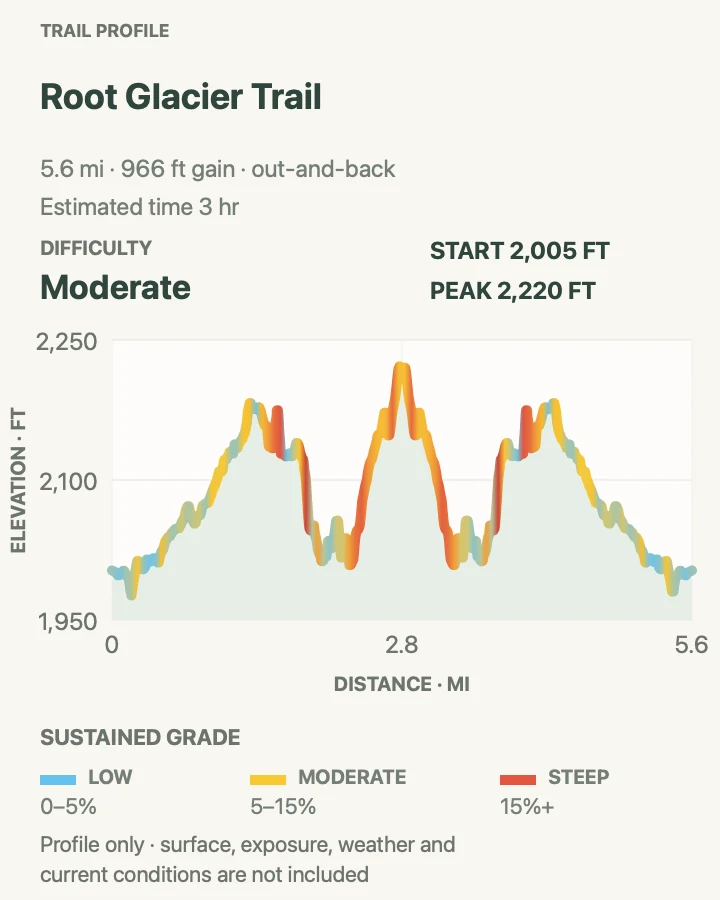
| Root Glacier Trail and 2026 Access Reroute | About 5.7 miles round trip on the mapped route | 3 to 5 hours | Moderate | The park's signed land approach to Root Glacier |
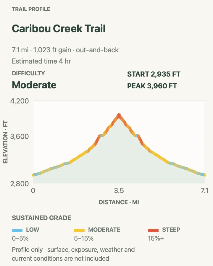
| Caribou Creek Trail | About 7.1 miles round trip | 3 to 4 hours | Moderate | A half-day Nabesna hike into the Mentasta foothills |
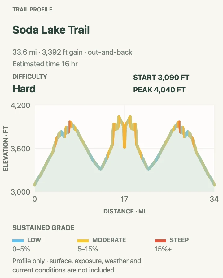
| Soda Lake Trail | About 34 miles round trip | Multi-day backpacking route | Hard | An experienced party seeking a remote Mentasta backpack |
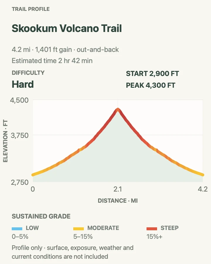
| Skookum Volcano Trail | About 4.3 miles round trip | 2.5 to 4 hours | Hard | A short, steep geology route to a high pass |
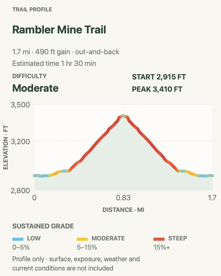
| Rambler Mine Trail | About 1.7 miles round trip | 1.5 to 2 hours | Moderate | A short, steep walk to protected mining remains |
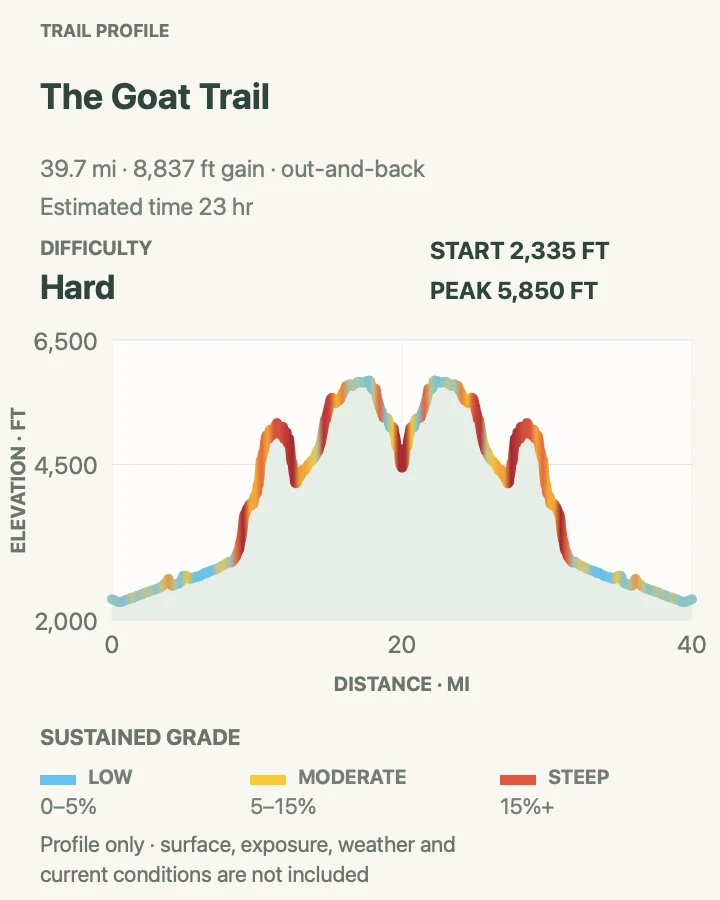
| The Goat Trail Backcountry Route | About 40.3 miles on the mapped variation | Multi-day expedition | Expert | Advanced backpackers with exposed off-trail navigation skills |
Crystalline Hills Trail
- Distance
- About 2.8 miles
- Elevation gain
- 760 feet
- Time
- 2 to 3 hours
- Difficulty
- Moderate
- Route type
- Loop
- Parking
- Use the signed pullout on the north side of McCarthy Road at mile 34.8; look closely for the wooden trail sign.
- Best time
- A dry summer morning, before the forest mosquitoes and road traffic are at their busiest.
- Pets
- Leashed, controlled dogs are allowed; watch for wildlife and seasonal trapping activity.
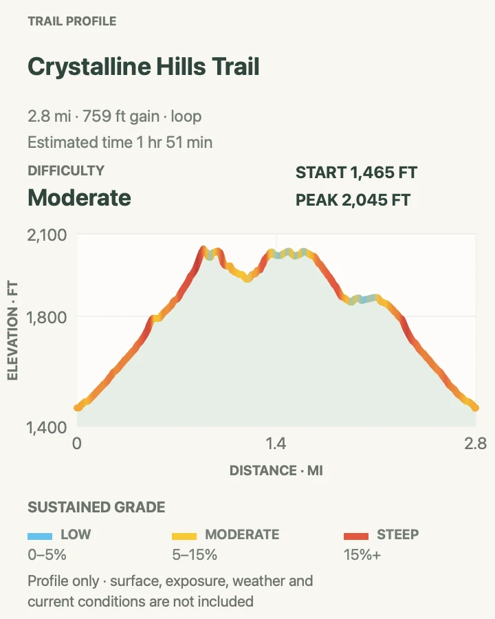
Crystalline Hills is the most straightforward road-accessed loop in this set. The mapped line measures 2.8 miles, while the NPS description rounds the maintained loop to 2.5. It climbs gradually through dense forest beneath steep hillsides, with a short side trail after roughly half a mile leading toward an open view of the Chitina River valley, Moose Lake, and the Chugach Mountains.
The loop itself is moderate; scrambling higher into the Crystalline Hills is an optional off-trail extension with a different risk level. Loose slopes and route finding begin as soon as you leave the maintained line. Complete the signed loop unless you have the navigation skills, weather margin, and footwear for steeper terrain, and do not create new paths through vegetation.
What helps on this route
- Save the mile 34.8 location offline because the small sign is easy to pass at road speed.
- Carry insect repellent or a head net for the shaded forest section in midsummer.
Terrain and access: Forest tread with a gradual climb, a short viewpoint spur, roots and mud after rain, and optional steep scrambling outside the maintained loop.

West Kennicott Glacier View Trail
- Distance
- About 2.1 miles round trip
- Elevation gain
- 150 feet
- Time
- 1 to 1.5 hours
- Difficulty
- Easy
- Route type
- Out and back
- Parking
- Use a signed public or paid lot at the end of McCarthy Road and verify the local trail access before leaving the parking area.
- Best time
- A clear summer morning after several dry days, when the local tread is less muddy.
- Pets
- Keep dogs leashed and under physical control; local parcels and posted rules take precedence.
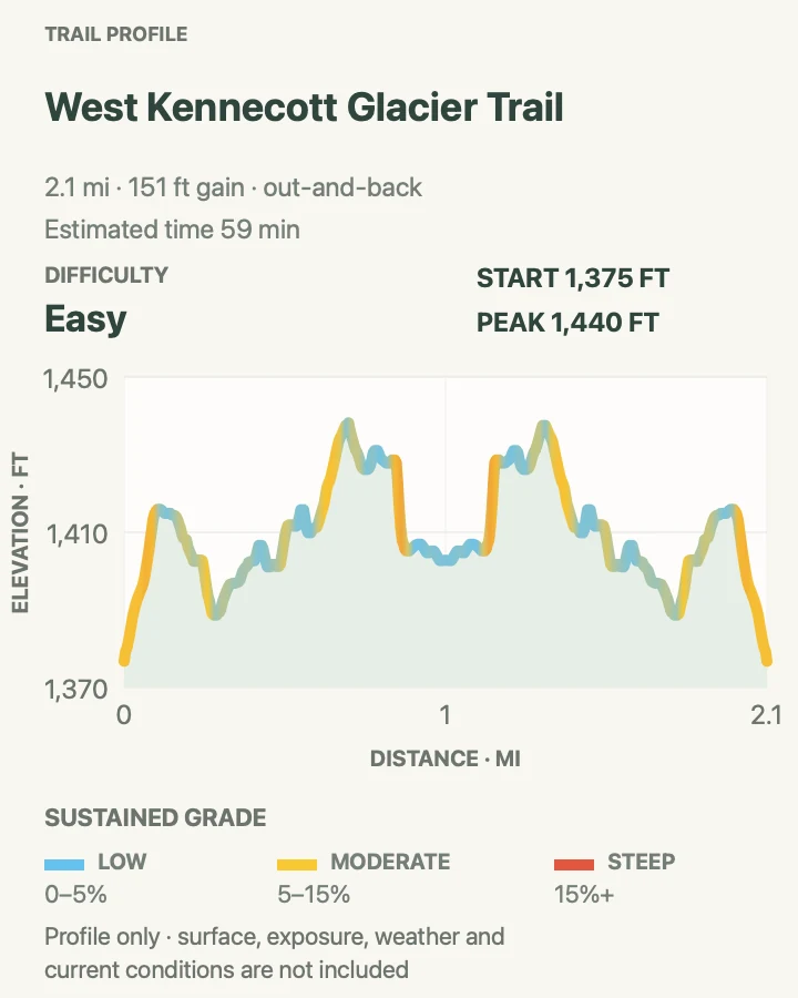
This local west-side path starts near the Kennicott River parking area and approaches a view over glacial terrain without making the longer trip to Kennecott Mill Town. The preserved route is 2.1 miles round trip with a modest climb. It is a gateway-area walk rather than the NPS Wagon Road to Kennecott or the signed Root Glacier access, so do not use those names or directions interchangeably.
Ownership around the road end is mixed, and access details can change. Begin only from a signed trail connection, remain on the established path, and respect gates and private-property notices. Mud, mosquitoes, and brush can make the short distance slower than expected. The viewpoint is a place to observe the glacier-fed lake and valley, not an invitation to descend an unsigned slope toward unstable sediment or cold water.
What helps on this route
- Ask the parking operator or a local information desk which signed access is open that day.
- Keep this walk separate from Root Glacier plans; it does not reach the 2026 NPS glacier-access reroute.
Terrain and access: Narrow forest and brush path with mud, insects, a moderate rise, and an open glacial-valley viewpoint near the turnaround.

Bonanza Mine Trail
- Distance
- About 8.6 miles round trip
- Elevation gain
- 3,920 feet
- Time
- 6 to 8 hours
- Difficulty
- Hard
- Route type
- Out and back
- Parking
- Reach Kennecott from the McCarthy road-end parking area by walking, biking where allowed, or taking a seasonal commercial shuttle; begin on Root Glacier Trail in the mill town.
- Best time
- A stable, clear summer day with an early start and no storm building over Bonanza Ridge.
- Pets
- Dogs must be leashed in the Kennecott historic area and controlled for the entire hike.
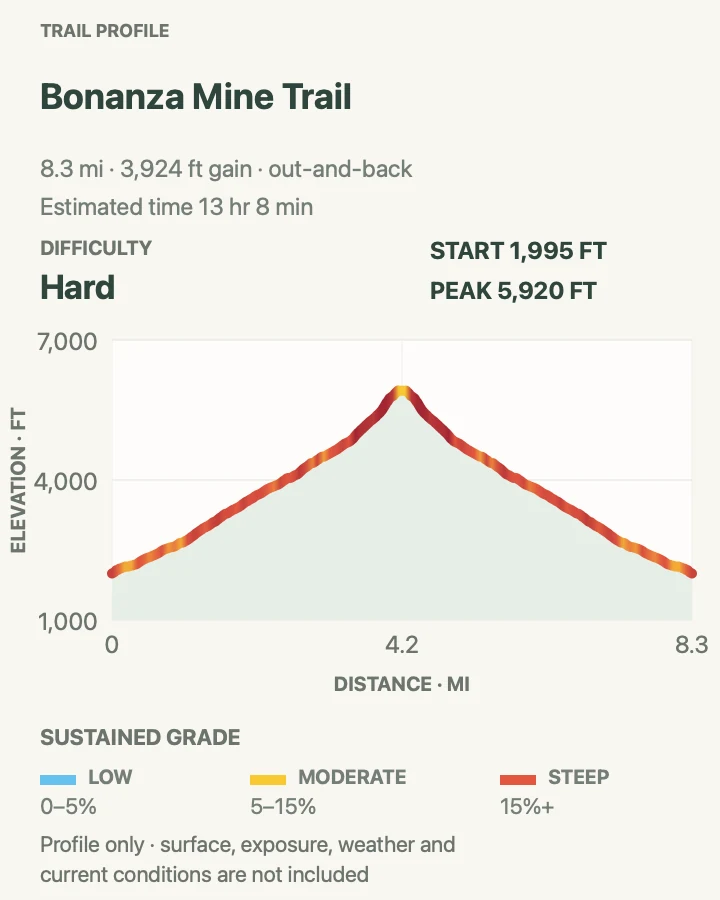
Bonanza is the major day-hike climb from Kennecott. The signed branch leaves Root Glacier Trail about half a mile from the mill town, then follows old mining roads and steeper path toward the breakover tram tower and mine buildings. The mapped route measures 8.6 miles; NPS rounds the trip to 9 miles and recommends allowing six to eight hours. Nearly all of the climbing comes after the junction.
Loose tread, exposure, and changing mountain weather make the descent as important as the summit goal. The mine structures and tunnels are unstable, and the entrance is restricted. Stay outside buildings and shafts, leave artifacts exactly where they are, and remain on the trail through private parcels. The ridge beyond the buildings adds exposure and should be attempted only with a clear weather margin.
What helps on this route
- Set a turnaround time that preserves daylight for the loose descent and the return from Kennecott.
- Carry all needed water; historic mine workings are not shelters or safe places to refill.
Terrain and access: Old mining road, forest switchbacks, sustained steep ascent, loose alpine tread, exposed ridge weather, and unstable historic structures.

Root Glacier Trail and 2026 Access Reroute
- Distance
- About 5.7 miles round trip on the mapped route
- Elevation gain
- 970 feet
- Time
- 3 to 5 hours
- Difficulty
- Moderate
- Route type
- Out and back
- Parking
- Reach Kennecott from the road-end parking area by foot, bicycle where allowed, or seasonal shuttle; start north from the Kennecott Visitor Center.
- Best time
- A dry summer morning after confirming the signed reroute and glacier conditions with park staff.
- Pets
- Dogs must be leashed in the Kennecott historic area; steep debris and glacier travel make this a poor pet route.
The Kennecott approach follows Erie Mine Trail past Bonanza and Jumbo creeks toward Root Glacier. NPS opened a replacement access on August 3, 2026 after landslide danger closed the former spur. Continue about 1.8 miles to just beyond the Amazon Creek footbridge, then use the signed left turn. The reroute descends about 0.6 mile through brush, rocky talus, mud, and glacial debris to the ice edge.
The card distance follows the preserved 5.7-mile geometry; NPS describes the new access as roughly 2.5 miles one way to the glacier. Current signs and closure barriers override every map. Reaching the edge is a complete land hike. Anyone stepping onto the glacier needs appropriate traction, judgment around crevasses and meltwater, and the ability to recognize unstable margins. A guided glacier trip is the prudent choice for visitors without those skills.
What helps on this route
- Ignore the former access even if an older map or track points toward it; the landslide closure remains active.
- Put traction on before the steep transition to ice, as NPS advises, or stop on land.
Terrain and access: Historic trail followed by the signed 2026 descent over brush, talus, mud, and shifting glacial debris; ice beyond the access is technical terrain.

Caribou Creek Trail
- Distance
- About 7.1 miles round trip
- Elevation gain
- 1,020 feet
- Time
- 3 to 4 hours
- Difficulty
- Moderate
- Route type
- Out and back
- Parking
- Use the roadside parking on the north side of Nabesna Road near mile 18.9; the signed trail begins near mile 19.2.
- Best time
- A dry summer day when Caribou Creek is low and the Nabesna Road is passable.
- Pets
- Leashed, controlled dogs are allowed; creek crossings, wildlife, and trapping require extra caution.
Caribou Creek begins in low tundra and follows a dirt-and-rock corridor toward the Mentasta Mountains. The mapped out-and-back is 7.1 miles, close to the NPS trail description of roughly six to seven miles depending on the turnaround. The first section is relatively easy; later crossings and climbing account for the moderate rating and much of the measured gain.
The creek is the controlling hazard. Rain and snowmelt can turn ordinary steps into unsafe crossings, and the return may be higher than the outbound leg. Expect mud where motorized subsistence use has affected the corridor, give wildlife room, and do not continue merely because a public-use cabin or a chosen mileage is ahead. The valley and Wrangell Mountain views remain worthwhile with an early turnaround.
What helps on this route
- Park at the designated pullout rather than on private land or within a drainage.
- Evaluate every crossing for the return trip and turn around before water reaches an unsafe level.
Terrain and access: Low tundra, dirt track, rocky streambed, mud, repeated creek crossings, and a gradually steeper approach toward the Mentasta Mountains.

Soda Lake Trail
- Distance
- About 34 miles round trip
- Elevation gain
- 3,390 feet
- Time
- Multi-day backpacking route
- Difficulty
- Hard
- Route type
- Out and back
- Parking
- Use the Lost Creek trailhead near mile 31.2 of Nabesna Road; follow the currently signed Soda Lake reroute rather than the closed old access.
- Best time
- A settled summer window after the Slana Ranger Station confirms low creeks and the current route junction.
- Pets
- Leashed dogs are legally allowed but are not recommended for this remote route with repeated water crossings and wildlife.
Soda Lake is a backcountry trip, not a long day hike. The mapped out-and-back is 34 miles and follows Lost Creek before turning east across rolling ground toward Platinum and Soda creeks. NPS describes 12 miles from the Soda Lake junction to Soda Creek and another 2.5 miles to the lake; the approach along Lost Creek accounts for the remaining distance. The former early junction is closed, so use the signed reroute farther up Lost Creek.
Beyond the motorized-use endpoint, travel continues on foot toward a mineral spring and Soda Lake. Tread becomes intermittent, creek beds replace constructed trail, and spring or storm runoff can make crossings impassable. NPS recommends this country only for experienced parties able to navigate with map and compass. Carry bear-resistant food storage, plan several days rather than an hour-based pace, and speak with a Slana ranger before committing.
What helps on this route
- Confirm the current junction location; do not follow the closed old track toward private inholdings.
- Build an extra weather day into food, fuel, and air-free logistics because high water can halt travel.
Terrain and access: Long gravel and dirt approach, mud, rolling tundra, brush, multiple creek beds and crossings, loose scree near the lake, and intermittent unmarked tread.

Skookum Volcano Trail
- Distance
- About 4.3 miles round trip
- Elevation gain
- 1,400 feet
- Time
- 2.5 to 4 hours
- Difficulty
- Hard
- Route type
- Out and back
- Parking
- Park at the signed Nabesna Road trailhead near mile 36.8 without blocking the road or creek drainage.
- Best time
- A dry summer morning with low creek water and clear visibility for route finding near the pass.
- Pets
- Leashed, controlled dogs are allowed, but repeated creek crossings and Dall sheep habitat make leaving pets behind sensible.
Skookum climbs through an eroded volcanic system of lava flows, domes, vents, and resistant dikes. The mapped out-and-back is 4.3 miles; NPS describes about 2.5 miles one way to the pass, with variations created by washouts and route choices. After roughly 0.8 mile through spruce and alder, travel enters a cobble creek bed and crosses water several times before the drainage forks toward the pass.
Constructed tread fades near fragile alpine plants, and cairns may be missing after a washout. Navigation skill matters more than the modest mileage. The optional rough loop through an unmarked southern creek bed adds difficult travel and road walking; it is not included in this mapped out-and-back. Return the way you came unless you have separately planned and verified that extension.
What helps on this route
- Carry footwear that protects feet in cold water; NPS specifically advises against crossing barefoot.
- Mark the trailhead and drainage fork offline so a missing cairn does not determine the route.
Terrain and access: Gravel alluvial fan, spruce and alder, repeated shallow crossings, loose cobble creek bed, steep climb, and unconstructed alpine route near the pass.

Rambler Mine Trail
- Distance
- About 1.7 miles round trip
- Elevation gain
- 490 feet
- Time
- 1.5 to 2 hours
- Difficulty
- Moderate
- Route type
- Out and back
- Parking
- Continue carefully through the private road corridor at mile 42 and use the public gravel parking area about 1,000 feet beyond it; never park on the private airstrip.
- Best time
- A clear summer afternoon after confirming that the far end of Nabesna Road is passable.
- Pets
- Keep dogs leashed around private property, wildlife, and unstable structures.
Rambler begins beyond the maintained end of Nabesna Road. Follow the old road for about a third of a mile, then take the trail climbing through spruce and alder toward the mine. The mapped round trip is 1.7 miles, close to the 1.5-mile NPS handout, and the steepest gain is concentrated in roughly half a mile. A faint route continues uphill, but it is not needed to visit the historic site.
The mine opening, tunnels, buildings, and surrounding structures are deteriorated and hazardous. Observe them from safe ground, stay out of every opening, and leave artifacts in place. There is no dependable water on the route. Private property and an active airstrip lie near the road end, so parking and access discipline are part of the hike rather than optional etiquette.
What helps on this route
- Verify the exact public parking area before leaving the vehicle; do not stop on the private airstrip.
- Carry water from the trailhead and treat the mine as an exterior viewpoint, not a structure to enter.
Terrain and access: Level historic road followed by a short steep forest climb, faint unmaintained continuation, loose ground, and unstable mine remains.

The Goat Trail Backcountry Route
- Distance
- About 40.3 miles on the mapped variation
- Elevation gain
- 8,840 feet
- Time
- Multi-day expedition
- Difficulty
- Expert
- Route type
- Remote route variation
- Parking
- There is no road trailhead. Arrange a licensed air taxi for a Skolai Pass drop-off and Wolverine-area pickup, or the reverse, only after a backcountry consultation.
- Best time
- A ranger-vetted summer weather window coordinated with the air taxi and an experienced expedition party.
- Pets
- Do not bring pets on this exposed fly-in route; aircraft, cliffs, wildlife, and rescue limitations make them an added hazard.
The Goat Trail is a historic name, not a promise of tread. NPS describes a roughly 25-to-30-mile point-to-point route between Skolai Pass and Wolverine, with variations through Chitistone Pass, the upper Chitistone River, Hasen Creek, and optional Doubtful and Grotto creek country. The preserved mapped variation is 40.3 miles because it follows a longer line. It should be read as one route record, not a universal track to copy blindly.
Large drop-offs, exposed cliff traverses, talus, river hazards, and continuous route finding put this trip outside ordinary trail-hiking judgment. Both ends require chartered flights, and weather can delay pickup. Consult a Wrangell-St. Elias backcountry ranger with the exact geometry before booking; confirm that it matches the intended airstrips and current conditions. Carry expedition-level navigation, food storage, emergency communication, and contingency supplies.
What helps on this route
- Send the exact planned line and airstrip coordinates to both the backcountry ranger and air taxi; the route name alone is insufficient.
- Carry enough food and shelter for a weather-delayed pickup, plus a communication plan that does not depend on cell service.
Terrain and access: Continuous off-trail navigation across alpine tundra, exposed cliff bands, steep talus, river and creek terrain, and remote airstrip approaches.

Official planning sources
Trail access and safety details were checked against these National Park Service pages. The maps and profiles follow the corresponding route geometry.
- NPS: Wrangell-St. Elias day hiking overview
- NPS: McCarthy Road and Kennecott trails
- NPS: Root Glacier access restored by 2026 reroute
- NPS: Root Glacier and Erie Mine Trail handout
- NPS: Bonanza Mine Trail handout
- NPS: Crystalline Hills Trail
- NPS: Nabesna Road trails
- NPS: Nabesna Road guide and current access cautions
- NPS: Caribou Creek Trail and Cabin handout
- NPS: Skookum Volcano Trail handout
- NPS: Rambler Mine Trail handout
- NPS: Soda Lake Trail and recreational ORV route status
- NPS: Backpacking routes and the Goat Trail
- NPS: Driving park roads
- NPS: Front-country hiking, pets, and reservations
Map data © OpenStreetMap contributors. Trail geometry and planning details include National Park Service public information.