14 Best Hikes in Sequoia National Park
Fourteen Sequoia National Park hikes from the foothills to Giant Forest and the alpine Lakes Trail, with custom terrain maps, elevation profiles, access notes, and live NPS alerts.
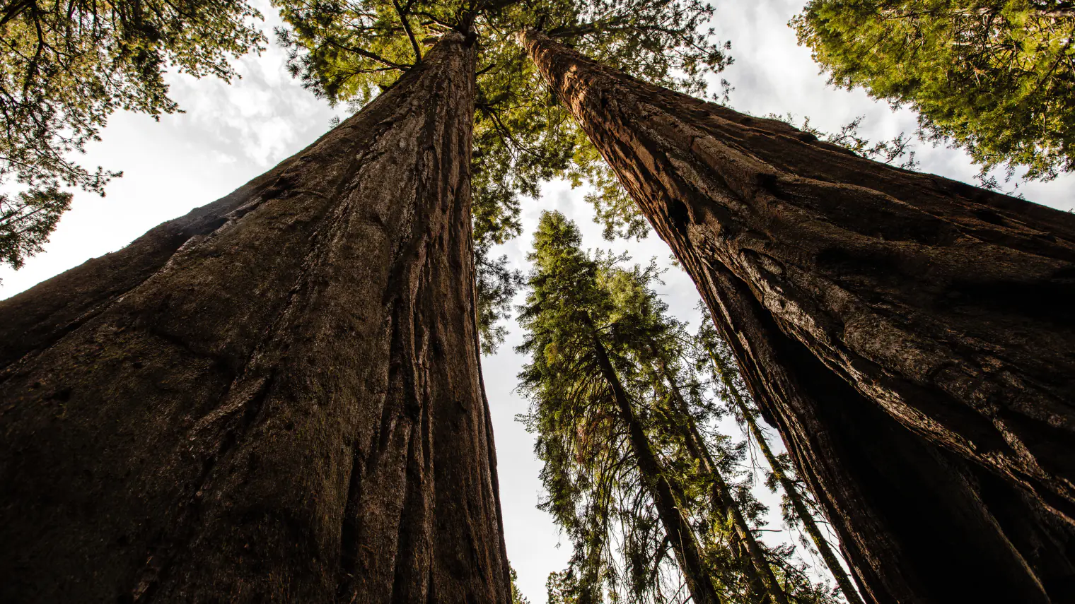
Sequoia changes quickly with elevation. Marble Falls begins in hot foothill chaparral, the Giant Forest walks sit near 6,000 to 7,000 feet, and the Wolverton routes climb into exposed alpine country. A comfortable morning near the entrance can therefore become a cold, stormy afternoon above the tree line. Match the route to both the forecast and the elevation band, then carry enough water for the warmer part of the day.
These fourteen hikes are arranged from the foothills through Giant Forest, Lodgepole, Wolverton, and Little Baldy. The short grove walks can share a shuttle day, but Pear Lake and Alta Peak are full-day commitments. Distances on the trail cards follow the route geometry used for the terrain maps and measured profiles. They can differ from rounded values on an NPS sign or from a temporary construction detour.
Official trail, road, and safety information was checked on August 30, 2026. Congress Trail reconstruction is changing part of its usual loop through the end of September, while trail, shuttle, fire, river, and road conditions can change sooner. Read the live alert and weather panels before leaving service, then confirm long alpine plans at a visitor center or with a ranger.
Live park weather
Sequoia National Park
Giant Forest Museum
Loading the latest conditions and alerts…
What changes a hiking day here
Plan around elevation, not the entrance forecast
Giant Forest and Lodgepole sit roughly 6,000 to 7,000 feet above sea level, and the Wolverton trails climb much higher. Heat near Ash Mountain can coexist with cold rain, hail, or lightning on Alta Peak. Check the forecast for the route's elevation, carry layers, and turn around before a storm reaches an exposed ridge. Altitude can also make a familiar distance feel harder.
Use the shuttle and outer lots in Giant Forest
General Sherman, Giant Forest Museum, Moro Rock, and Crescent Meadow parking can fill early. Summer weekend and holiday controls often reserve Moro Rock and Crescent Meadow roads for park shuttles. Park in an open designated lot, know the last shuttle time, and do not build an itinerary around driving to every short trailhead. Current road and shuttle rules take precedence over older maps.
Congress Trail has a 2026 construction detour
NPS reports a Congress Trail reconstruction closure through the end of September 2026. The grove remains reachable, but the familiar short loop is temporarily changed and some visitors must retrace part of the route. The card below describes the mapped full circuit. Check the posted closure map and follow barriers rather than attempting to complete a blocked segment.
Give rivers and waterfalls a wide margin
Cold, fast water is a recurring hazard near Tokopah and Marble Falls. Smooth granite can be wet far beyond the visible channel, and a calm-looking edge can conceal strong current. Stay on the maintained trail, keep back from wet slabs, and never enter swift water for a photo or shortcut. Waterfall flow is usually strongest in late spring and early summer.
Keep food and packs under direct control
Black bears use the same forests and meadows as hikers. Never leave a food-bearing pack on the trail, even for a short detour, and use the required storage at campgrounds and trailheads. Carry food, scented items, and trash with you during a day hike. If a bear occupies the route, give it room and follow current ranger guidance.
Snow can outlast the warm valley season
The Lakes Trail, Watchtower, Alta Peak, and Little Baldy can retain snow or ice after lower trails are dry. A summer date alone does not establish safe footing. Read the current trail-condition report, carry traction only when you know how to use it, and choose a lower route when steep traverses are icy or route finding is uncertain.
Day hikes do not need a wilderness permit
The routes in this guide are presented as day hikes, so they do not require an overnight wilderness permit. Camping beyond developed campgrounds does. Pear Lake and Alta Peak are long enough that a late start can accidentally become an overnight emergency; begin early, carry a light, and set a firm turnaround time.
Pets stay off every park trail
Pets are not allowed on Sequoia National Park trails. Leashed pets are generally limited to roads, parking areas, campgrounds, and picnic areas where posted rules allow them. That restriction includes short paved grove walks. Trained service animals are allowed, but wildlife and steep terrain still require advance planning.
| Trail | Distance | Time | Difficulty | Best for |
|---|---|---|---|---|
| Marble Falls Trail | About 6.7 miles round trip | 3.5 to 5 hours | Moderate | A longer foothills walk to a granite cascade |
| Moro Rock | About 0.5 mile round trip | 30 minutes to 1 hour | Moderate | A short stair climb to a high Sierra viewpoint |
| Hanging Rock Trail | About 0.3 mile round trip | 20 to 40 minutes | Moderate | A brief granite overlook near Moro Rock |
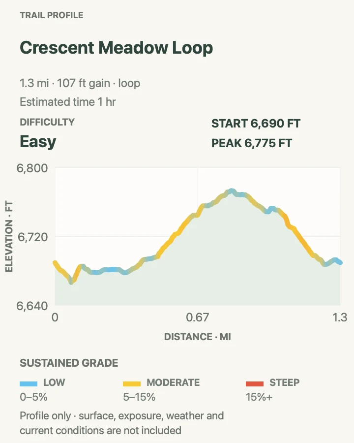
| Crescent Meadow Loop | About 1.3 miles around the loop | 45 minutes to 1.5 hours | Easy | A compact sequoia-and-meadow circuit |
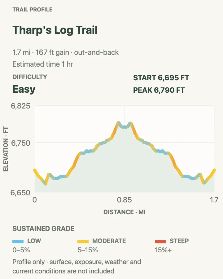
| Tharp's Log Trail | About 1.7 miles round trip | 1 to 1.5 hours | Easy | Human history within the Giant Forest trail network |
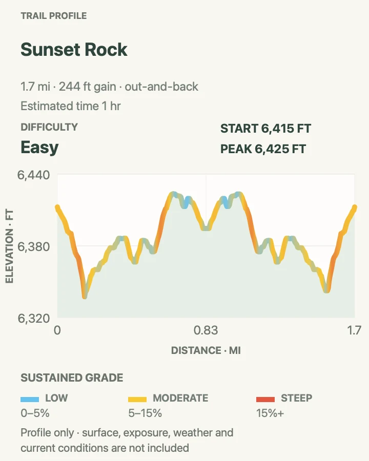
| Sunset Rock | About 1.7 miles round trip | 1 to 1.5 hours | Easy | A quieter granite viewpoint from Giant Forest Museum |
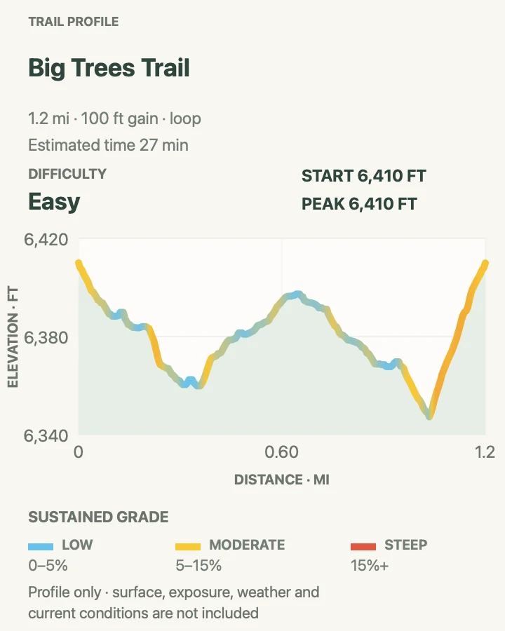
| Big Trees Trail | About 1.2 miles around the loop | 30 minutes to 1 hour | Easy | An accessible introduction to giant sequoia ecology |
| General Sherman Tree Trail | About 1.1 miles round trip | 45 minutes to 1.5 hours | Easy | A direct visit to the General Sherman Tree |
| Congress Trail | About 2.9 miles around the mapped loop | 1.5 to 2.5 hours | Easy | A longer walk among named Giant Forest sequoia groups |
| Tokopah Falls | About 4.1 miles round trip | 2 to 3 hours | Moderate | A granite-canyon walk beside the Marble Fork |
| Pear Lake via Lakes Trail | About 12.2 miles round trip | 7 to 9 hours | Hard | A full-day alpine lake route past Heather and Emerald Lakes |
| Watchtower Trail | About 8.5 miles round trip | 5 to 7 hours | Hard | An exposed granite viewpoint without continuing to Pear Lake |
| Alta Peak via Lakes Trail | About 13.8 miles round trip | 8 to 10 hours | Hard | A strenuous summit day from Wolverton |
| Little Baldy Trail | About 3.4 miles round trip | 2 to 3 hours | Moderate | A moderate climb to a broad granite summit view |
Marble Falls Trail
- Distance
- About 6.7 miles round trip
- Elevation gain
- 1,630 feet
- Time
- 3.5 to 5 hours
- Difficulty
- Moderate
- Route type
- Out and back
- Parking
- Park at Potwisha Campground and begin near campsite 14; do not occupy a campsite parking spur unless assigned there.
- Best time
- A cool spring morning, when the cascade has water and foothill heat is manageable.
- Pets
- Pets are not permitted on this trail.
Marble Falls climbs from Potwisha through chaparral above the Middle Fork Kaweah River. The mapped round trip is 6.7 miles, a little shorter than twice the rounded NPS one-way figure. Shade is limited and the low elevation makes heat the deciding factor for much of the year. The destination is a broad granite cascade, not a safe swimming area.
Begin beside campsite 14 and stay on the signed route as it rises away from the campground. Poison oak grows in the foothills, rattlesnakes may use warm sections of tread, and exposed turns can feel much hotter on the return. Carry all needed water, leave the slick rock near the falls alone, and turn around early if the trail is already hot on the outbound climb.
What helps on this route
- Start at or soon after first light in warm weather; the return crosses exposed slopes later in the day.
- Confirm parking with campground staff if the visitor spaces are full rather than blocking a campsite or road.
Terrain and access: Steady dirt climb through exposed chaparral, with rocky tread, poison oak habitat, and slick granite near the cascade.

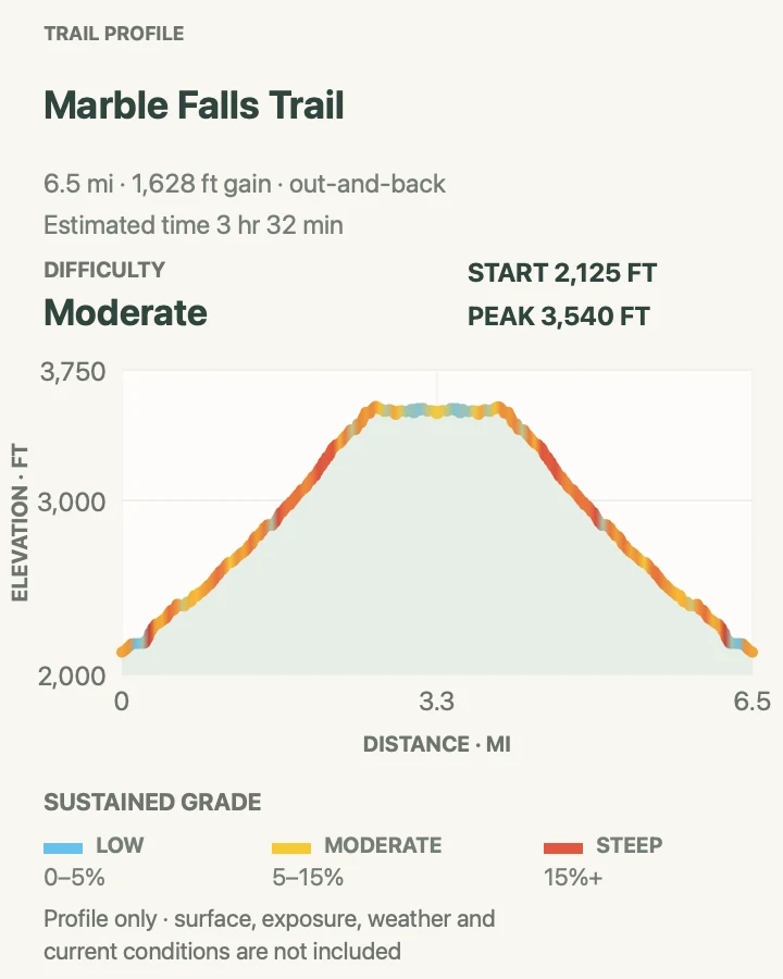
Moro Rock
- Distance
- About 0.5 mile round trip
- Elevation gain
- 290 feet
- Time
- 30 minutes to 1 hour
- Difficulty
- Moderate
- Route type
- Out and back
- Parking
- Use the Moro Rock shuttle stop when summer vehicle controls are active; otherwise park only in the signed small lot.
- Best time
- A clear morning before crowds, heat, or afternoon thunderstorms reach the exposed stairs.
- Pets
- Pets are not permitted on this trail.
Moro Rock gains its view on a concrete-and-stone stairway cut into the granite dome. NPS counts roughly 300 feet of climbing on the stairs, and the mapped round trip is only half a mile. Handrails protect much of the line, but the route is narrow, exposed, and busy. Passing takes patience, especially where the stairs squeeze between rock and a steep drop.
Do not climb when ice or snow covers the steps. Thunderstorms are another firm reason to stay down because the upper dome has no shelter. Summer access often works best by shuttle from Giant Forest Museum. If the small vehicle lot is open but full, continue to an approved parking area instead of waiting in the road.
What helps on this route
- Carry only what you can keep close to your body; bulky packs make narrow passing places awkward.
- Wait for a clear weather window and descend immediately if thunder builds over the Sierra crest.
Terrain and access: Steep stone and concrete stairs with handrails, narrow passing points, full exposure, and no safe footing when icy.

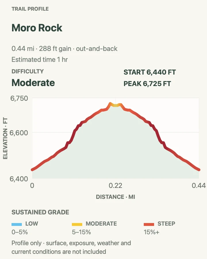
Hanging Rock Trail
- Distance
- About 0.3 mile round trip
- Elevation gain
- 85 feet
- Time
- 20 to 40 minutes
- Difficulty
- Moderate
- Route type
- Out and back
- Parking
- Use the same Moro Rock access plan and signed parking or shuttle stop; the path begins near the Moro Rock area.
- Best time
- A quiet morning paired with Moro Rock before the shuttle corridor becomes busy.
- Pets
- Pets are not permitted on this trail.
Hanging Rock is a short side outing in the Moro Rock area, but the final granite viewpoint deserves more care than its distance suggests. The mapped walk is about three-tenths of a mile. It reaches an open rock shelf with a clear view toward Moro Rock and the surrounding canyon rather than following Moro's built stairway.
The route is most useful as a separate stop when the shuttle is already part of the day. Granite near the edge can be sandy or wet, and the viewpoint does not need to be approached to its outermost lip. Keep children close, stay on durable surfaces, and return the same way without descending on informal lines.
What helps on this route
- Pair this with Moro Rock only when the weather remains dry and stable; both viewpoints are exposed.
- Stop well back from the outer edge where loose sand on granite can reduce traction.
Terrain and access: Short forest-and-granite path to an unguarded rock viewpoint, with uneven footing and exposed edges.

Crescent Meadow Loop
- Distance
- About 1.3 miles around the loop
- Elevation gain
- 110 feet
- Time
- 45 minutes to 1.5 hours
- Difficulty
- Easy
- Route type
- Loop
- Parking
- Use the Crescent Meadow shuttle stop when vehicle controls are active; otherwise use the signed day-use lot.
- Best time
- Morning or late afternoon, when meadow light is soft and wildlife can be watched from a distance.
- Pets
- Pets are not permitted on this trail.
Crescent Meadow Loop circles a wet meadow bordered by giant sequoias and mixed-conifer forest. The 1.3-mile line is gentle, but roots, damp soil, and seasonal mosquitoes keep it from feeling like a paved grove path. Stay on the maintained tread to protect the meadow margin and avoid widening muddy sections.
Deer and black bears sometimes feed near the meadow. Watch from the trail and give every animal room; moving closer for a photograph can block its path into cover. The loop can share a visit with Tharp's Log, but use the map at junctions because several Giant Forest trails intersect around the meadow.
What helps on this route
- Bring repellent during the early-summer mosquito season and avoid stepping into the meadow to bypass wet tread.
- Note the last shuttle departure before starting if private vehicles are restricted on Crescent Meadow Road.
Terrain and access: Mostly gentle forest trail with roots, damp meadow margins, several junctions, and seasonal mosquitoes.

Tharp's Log Trail
- Distance
- About 1.7 miles round trip
- Elevation gain
- 170 feet
- Time
- 1 to 1.5 hours
- Difficulty
- Easy
- Route type
- Out and back
- Parking
- Use the Crescent Meadow shuttle stop or signed day-use lot, subject to current road controls.
- Best time
- A dry morning when the meadow-side junctions are quiet and easy to follow.
- Pets
- Pets are not permitted on this trail.
Tharp's Log follows the Crescent Meadow network to a fallen sequoia that early settler Hale Tharp used as a summer shelter. The 1.7-mile out-and-back passes giant trees and meadow edges, then reaches the preserved log structure. Treat the cabin as a historic site, leave every object in place, and keep food secured while stopping there.
Several nearby paths continue toward Log Meadow and the wider Giant Forest system. The signed route and map prevent a short history walk from becoming an unintended loop. Damp ground and exposed roots are common beside the meadow, while the sequoia duff can hide small changes in tread height.
What helps on this route
- Photograph the junction map near Crescent Meadow so the return remains obvious without a signal.
- Look inside the historic log without touching or moving material around the structure.
Terrain and access: Gentle forest and meadow-edge trail with roots, soft duff, damp patches, and several connecting paths.

Sunset Rock
- Distance
- About 1.7 miles round trip
- Elevation gain
- 240 feet
- Time
- 1 to 1.5 hours
- Difficulty
- Easy
- Route type
- Out and back
- Parking
- Park at Giant Forest Museum or arrive by park shuttle, then use the signed trail from the museum area.
- Best time
- Late afternoon on a clear day, with enough daylight reserved for the forest return.
- Pets
- Pets are not permitted on this trail.
Sunset Rock leaves the Giant Forest Museum area for a broad granite slab overlooking the western foothills. The 1.7-mile out-and-back crosses forest before opening onto rock. Its name suits evening light, but the return under trees darkens before the open sky does. Carry a light and know the museum-area shuttle or parking schedule.
The slab has no formal railing and can hold loose grit. Walk only as far as dry traction and personal comfort allow. The route offers a different view from Moro Rock without its staircase or upper-dome exposure, though smoke, haze, and approaching storms can erase the advantage of waiting for sunset.
What helps on this route
- Set a turnaround time from the shuttle schedule and the forest's earlier loss of usable light.
- Stay off wet granite and avoid the outer slab if wind or smoke reduces visibility.
Terrain and access: Forest path leading to an open, unrailed granite slab with loose grit and limited late-day light on return.

Big Trees Trail
- Distance
- About 1.2 miles around the loop
- Elevation gain
- 100 feet
- Time
- 30 minutes to 1 hour
- Difficulty
- Easy
- Route type
- Loop
- Parking
- Park at Giant Forest Museum or use the shuttle; follow the paved connector to Round Meadow.
- Best time
- Morning for cooler air, lighter traffic, and readable interpretive stops around Round Meadow.
- Pets
- Pets are not permitted on this trail.
Big Trees Trail circles Round Meadow on a paved interpretive path. NPS describes the formal meadow loop as roughly three-quarters of a mile; the 1.2-mile mapped outing includes the approach from the Giant Forest Museum area. Displays explain how fire, moisture, and meadow edges shape the giant sequoia grove.
The path is one of the most approachable forest routes in the park, but temporary repairs, snow, or debris can affect accessibility. Check with the museum or a ranger when step-free travel is important. Keep wheels and feet on the pavement so the saturated meadow edge and shallow sequoia roots remain undisturbed.
What helps on this route
- Ask at Giant Forest Museum about current surface conditions before relying on the full loop for accessible travel.
- Read the displays in sequence around Round Meadow; they supply context that is easy to miss on a fast lap.
Terrain and access: Paved, mostly level interpretive loop and connector beside a wet meadow, with seasonal snow or debris possible.

General Sherman Tree Trail
- Distance
- About 1.1 miles round trip
- Elevation gain
- 260 feet
- Time
- 45 minutes to 1.5 hours
- Difficulty
- Easy
- Route type
- Out and back
- Parking
- Use the main Sherman Tree lot and shuttle stop; accessible parking is available closer to the tree under posted rules.
- Best time
- Early morning or late afternoon, outside the busiest tour and shuttle period.
- Pets
- Pets are not permitted on this trail.
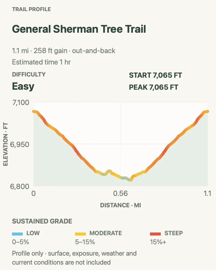
The main General Sherman route descends from the upper parking lot through the grove to the famous tree, then climbs back to the lot. The mapped round trip is 1.1 miles. It is paved and includes benches, but the return elevation at roughly 7,000 feet can surprise visitors who judged the route only by distance.
Crowds concentrate around the tree and the approach platform. Leave room for wheelchairs, strollers, and people resting on the grade, then use signed viewing space instead of stepping among shallow roots. Congress Trail continues from this area, but it should be a deliberate extension rather than an accidental turn at a busy junction.
What helps on this route
- Save energy for the uphill return to the main lot and pause at a bench before altitude symptoms build.
- Use the closer accessible lot only when eligible and follow its current seasonal access rules.
Terrain and access: Paved forest path with a sustained return climb, benches, crowded junctions, and high-elevation winter conditions.

Congress Trail
- Distance
- About 2.9 miles around the mapped loop
- Elevation gain
- 520 feet
- Time
- 1.5 to 2.5 hours
- Difficulty
- Easy
- Route type
- Loop when all segments are open
- Parking
- Use the General Sherman main lot or park shuttle, then descend the signed Sherman Tree approach.
- Best time
- Early morning, after checking the current 2026 construction closure and detour.
- Pets
- Pets are not permitted on this trail.
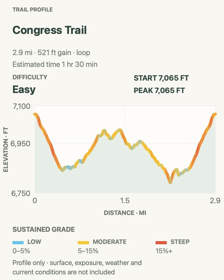
Congress Trail continues beyond General Sherman through groves containing the President Tree, Chief Sequoyah, the Senate, and the House. The usual mapped circuit is about 2.9 miles and provides more time among mature sequoias than the direct Sherman visit. Pavement and modest grades make the route approachable, though snow, debris, and altitude still matter.
During 2026 reconstruction, NPS has closed a section through the end of September and changed the familiar loop pattern. Follow the posted detour and expect to retrace part of the walk. Do not cross fencing or fresh construction to match the map. The route should be treated as an out-and-back whenever current signs prevent a complete circuit.
What helps on this route
- Photograph the current closure diagram before leaving General Sherman because the normal loop is temporarily altered.
- Count the uphill return to the Sherman parking area when setting the turnaround time.
Terrain and access: Mostly paved grove trail with rolling grades, high-elevation winter hazards, and a temporary 2026 construction detour.

Tokopah Falls
- Distance
- About 4.1 miles round trip
- Elevation gain
- 590 feet
- Time
- 2 to 3 hours
- Difficulty
- Moderate
- Route type
- Out and back
- Parking
- Use designated day-use parking near Lodgepole and walk through the campground to the trail beyond Marble Fork Bridge.
- Best time
- Late spring or early summer for stronger waterfall flow, after confirming snow and river conditions.
- Pets
- Pets are not permitted on this trail.
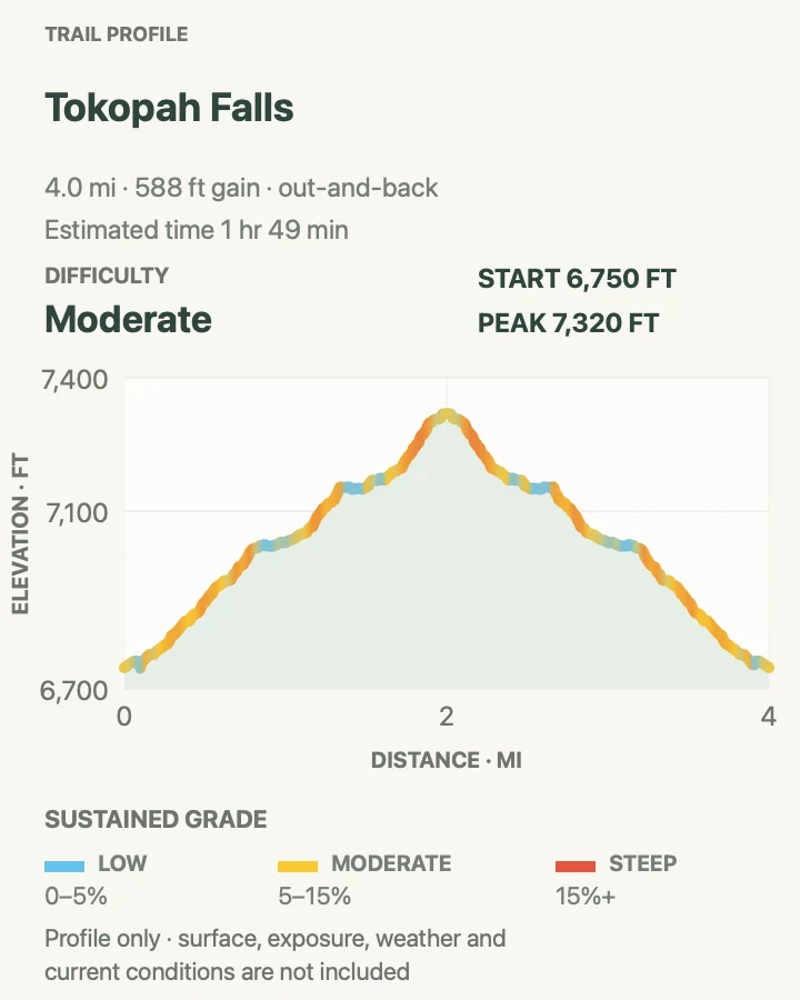
Tokopah Falls begins beyond the Marble Fork Bridge in Lodgepole Campground and follows the river into a granite-walled canyon. The mapped round trip is 4.1 miles, while NPS describes the maintained trail as about 1.7 miles each way. Forest gives way to rockier, more open tread as the canyon narrows.
The waterfall is usually strongest early in the warm season, the same period when cold water and slippery rock are most dangerous. Stay on the trail and view the cascade from dry ground. Summer flow can diminish sharply, so the canyon, river, and granite walls should be part of the reason for choosing the hike.
What helps on this route
- Walk quietly through the campground and do not use occupied campsite parking for day hiking.
- Keep back from the Marble Fork and polished granite even when the visible current appears calm.
Terrain and access: Forest and rocky canyon trail beside a cold river, with roots, granite blocks, seasonal snow, and slick waterfall approaches.

Pear Lake via Lakes Trail
- Distance
- About 12.2 miles round trip
- Elevation gain
- 3,130 feet
- Time
- 7 to 9 hours
- Difficulty
- Hard
- Route type
- Out and back
- Parking
- Use the signed Wolverton day-use lot and begin at the Lakes Trail trailhead.
- Best time
- A stable summer or early-fall day after snow has cleared from steep traverses.
- Pets
- Pets are not permitted on this trail.
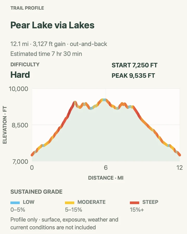
Pear Lake is the longest lake-focused day in this guide. From Wolverton, Lakes Trail climbs through forest and crosses exposed granite country past Heather and Emerald Lakes before reaching Pear Lake. The mapped out-and-back is 12.2 miles, with sustained elevation gain and little margin for a casual late start.
Snow or ice can make the Watchtower-side traverses hazardous well after lower trails are dry. Read the current trail report and choose the signed Hump route when NPS closes or advises against the exposed alternative. Treat the lakes as cold alpine water, protect food from bears and marmots, and turn around early enough to descend before dark.
What helps on this route
- Set separate turnarounds for Heather, Emerald, and Pear so the day can be shortened without improvising.
- Carry a light, layers, and the full water-treatment plan even when the morning at Wolverton is clear.
Terrain and access: Long forest-to-alpine route with sustained climbing, exposed granite traverses, seasonal snow, rocky tread, and cold lakes.

Watchtower Trail
- Distance
- About 8.5 miles round trip
- Elevation gain
- 2,100 feet
- Time
- 5 to 7 hours
- Difficulty
- Hard
- Route type
- Out and back
- Parking
- Use the signed Wolverton day-use lot and follow Lakes Trail toward the Watchtower junction.
- Best time
- A clear, snow-free summer morning with no thunderstorm threat.
- Pets
- Pets are not permitted on this trail.
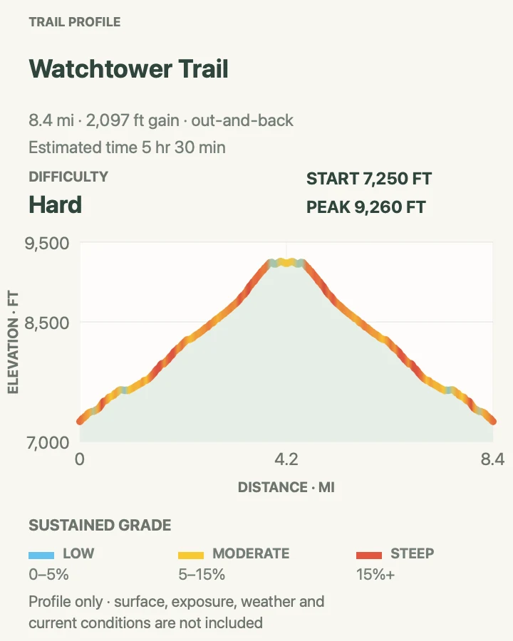
The Watchtower route shares the lower Lakes Trail with Pear Lake, then commits to the exposed granite side of the drainage. Its 8.5-mile mapped out-and-back reaches a distinct viewpoint above Tokopah Valley, making it a substantial destination without the extra distance to Pear Lake. Forested climbing comes first; open ledges and wider Sierra views arrive later.
NPS can close the Watchtower section when snow or ice makes the traverse unsafe. Obey that closure and use only a signed alternative. There is little protection from lightning near the viewpoint, and the return still requires several miles of rocky descent. This is a dry-weather route, not a place to test traction on a shaded snow patch.
What helps on this route
- Check the current Lakes Trail report for a Watchtower closure before committing to the junction.
- Turn back at the first thunder or unsafe snow; the exposed section has no sheltered waiting area.
Terrain and access: Sustained forest climb leading to exposed granite ledges, rocky tread, steep drop-offs, and lingering seasonal snow.

Alta Peak via Lakes Trail
- Distance
- About 13.8 miles round trip
- Elevation gain
- 4,040 feet
- Time
- 8 to 10 hours
- Difficulty
- Hard
- Route type
- Out and back
- Parking
- Use the signed Wolverton day-use lot and begin on the Lakes Trail system.
- Best time
- A long, stable summer day after the summit route is clear of hazardous snow.
- Pets
- Pets are not permitted on this trail.
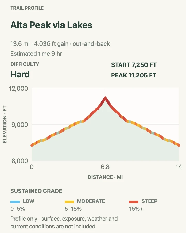
Alta Peak is a major day hike, not an automatic extension of a short Wolverton walk. The 13.8-mile mapped route climbs through forest, meadow, and increasingly open alpine terrain before the final summit approach. Elevation, loose rock, sun, and wind compound the mileage, while a high turnaround can still leave hours of descent.
Begin early with a firm weather window and a time-based turnaround. Water reported at creeks or meadows is seasonal and must be treated, so do not depend on an old condition report. The upper route offers little shelter from lightning. If clouds build or altitude symptoms do not improve with rest, descend rather than waiting near the summit.
What helps on this route
- Write down a turnaround time before starting and keep it even if the summit looks close.
- Carry sun protection, warm layers, a light, and enough water capacity for dry late-season conditions.
Terrain and access: Very long high-elevation route with sustained gain, rocky alpine tread, loose summit terrain, wind, and full weather exposure.

Little Baldy Trail
- Distance
- About 3.4 miles round trip
- Elevation gain
- 840 feet
- Time
- 2 to 3 hours
- Difficulty
- Moderate
- Route type
- Out and back
- Parking
- Use the signed roadside pullouts about six miles north of Lodgepole; park fully off Generals Highway.
- Best time
- Summer or fall after snow and ice have cleared from the shaded switchbacks.
- Pets
- Pets are not permitted on this trail.
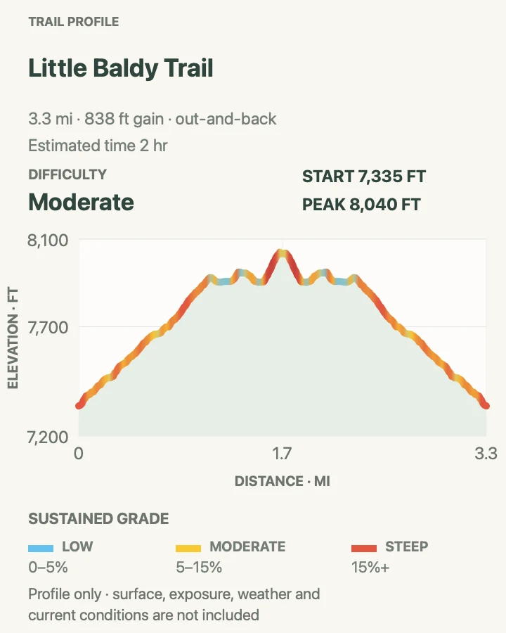
Little Baldy climbs through forested switchbacks to an open granite dome. NPS lists the trip at 3.4 miles round trip with about 790 feet of gain, matching the mapped distance here. The summit view reaches across the Giant Forest area and toward the Sierra, but the dome has no shelter from wind, lightning, or strong sun.
Roadside parking is limited to pullouts on both sides of Generals Highway. Cross only with a clear view of traffic and never leave part of a vehicle in the travel lane. Snow and ice can linger on the shaded trail in winter and spring. A dry summer or fall morning usually provides the most straightforward footing.
What helps on this route
- If both pullouts are full, return later rather than squeezing along the highway shoulder.
- Leave the open summit at the first sign of thunder and descend below the dome without delay.
Terrain and access: Dirt and rocky switchbacks through forest to an open granite dome, with highway access and seasonal ice.

Official planning sources
Trail access and safety details were checked against these National Park Service pages. The maps and profiles follow the corresponding route geometry.
- NPS: Giant Forest and Lodgepole planning
- NPS: Giant Forest day hikes
- NPS: Current conditions and alerts
- NPS: Current road conditions
- NPS: Current trail conditions
- NPS: Trail safety and the ten essentials
- NPS: Foothills day hikes and Marble Falls
- NPS: Little Baldy Trail
- NPS: Trail descriptions for Lakes Trail and Alta Peak
- NPS: General park safety
- NPS: Pet rules
Map data © OpenStreetMap contributors. Trail geometry and planning details include National Park Service public information.