8 Best Hikes in Wind Cave National Park
Eight Wind Cave hikes with reviewed terrain and satellite maps, elevation profiles, wildlife advice, trailhead logistics, and live NPS alerts.
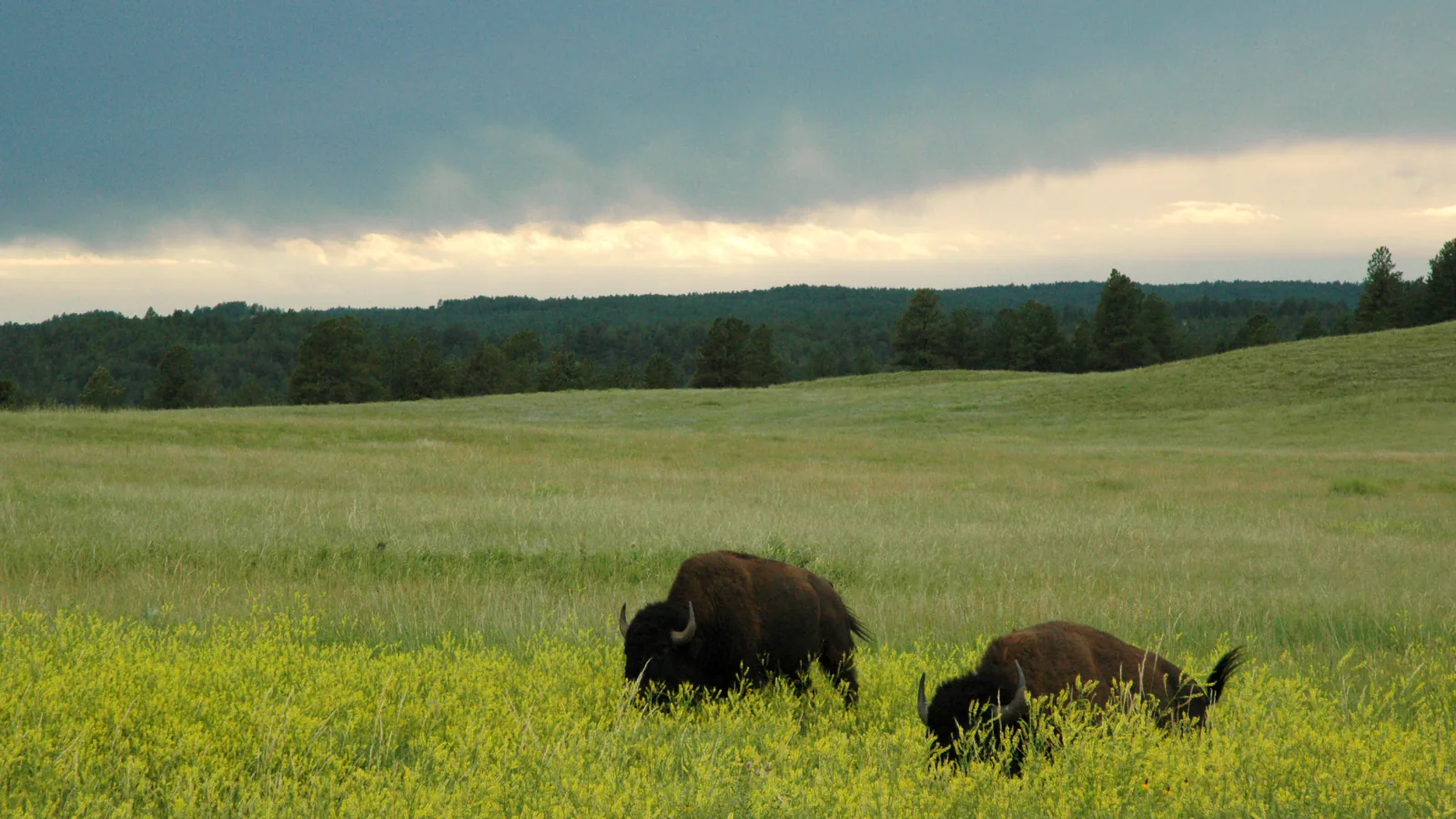
Wind Cave's memorable hiking is above the cave. More than 30 miles of official trail cross mixed-grass prairie, ponderosa forest, creek bottoms, and high ridges where bison can appear around a bend. The cave tour and the surface trail system are separate plans: cave access is ranger guided, while the park's surface remains open around the clock unless weather or an alert closes a route.
Eight hikes are enough to show that range without recycling every possible connector. Rankin Ridge and the Lookout Point loop are the recognizable first choices. Cold Brook Canyon and Prairie Vista cover shorter prairie walks. Boland Ridge and East Bison Flats trade crowds for distance and wildlife country. The long Centennial point-to-point is here for hikers who bring a shuttle plan, not because a 13-mile line makes a list look more impressive. Elk Mountain closes the guide with a genuinely useful short walk that also happens to be one of only two pet-friendly trails in the park.
Official information and the park alert feed were checked on August 29, 2026. Wind Cave Canyon Trail is closed for washout repairs through the end of August, and the park is under a temporary fire restriction that prohibits open and charcoal fires. The live panel below will replace this dated summary as NPS updates its feed. For the backcountry routes, carry your own water, download a map, and be willing to reverse course when bison occupy the trail. Cell service is limited and a quiet animal is not necessarily a safe animal.
What changes a hiking day here
Give bison the trail
NPS requires at least 25 yards between visitors and all wildlife and recommends more room around bison. If one is on or close to the route, stop early, back away, and choose another line or turn around. Do not squeeze past, stand your ground, or use the encounter as a photo opportunity. Bison can run about 35 mph and may charge with little warning.
Carry water; do not count on a creek
There are few reliable water sources on the trail system. Any backcountry water must be filtered, treated, or boiled, and dry late-summer conditions can remove the option altogether. Bring the day's supply from the start, especially for East Bison Flats, Boland Ridge, and the Centennial point-to-point.
Dress for grass, ticks, poison ivy, and hail
Long pants and closed shoes are practical here, not fussy. Ticks are common in tall grass and poison ivy grows along park trails. Summer afternoons often exceed 80°F and strong thunderstorms can produce large hail. Start exposed prairie routes early, carry an extra layer, and inspect for ticks after the hike.
Pets have only two trail choices
Leashed pets are allowed on Prairie Vista and the Elk Mountain Campground Trail. They are not permitted on the other trails or in the backcountry. A leash may be no longer than six feet, and pets cannot be left unattended. Tall grass also exposes dogs to ticks, so check them carefully afterward.
Separate cave tickets from the hiking plan
All cave tours are ranger guided and tickets can sell out. A trail closure on the surface does not automatically cancel cave tours, and a cave-tour ticket does not reserve trail parking. If combining the two, book the cave first and choose a short surface route with enough time to return to the visitor center.
Do not improvise around Wind Cave Canyon
The current NPS alert closes Wind Cave Canyon Trail for repair. That closure is not an invitation to walk the adjoining service road or invent a cross-country bypass. Follow signed access for the selected route, and ask at the visitor center if a planned connection uses the canyon.
Treat the Centennial route as a transport problem
The 13.3-mile Highland Creek-to-Badger Hole route is point to point and continues well beyond Wind Cave into Custer State Park. Arrange two vehicles or a Black Hills shuttle before starting. NPS does not allow overnight trailhead parking without a camping permit, and it does not issue camping permits merely to authorize parking.
| Trail | Distance | Time | Difficulty | Best for |
|---|---|---|---|---|
| Lookout Point and Centennial Trail Loop | About 4.8 miles on the reviewed loop | 2 hr 30 min | Moderate | The best single half-day sample of Wind Cave's rolling prairie and creek country |
| Rankin Ridge Interpretive Trail | 1 mile round trip | 1 hr | Moderate | The park's highest viewpoint in a compact one-hour walk |
| Cold Brook Canyon Trail | About 2.7 miles round trip on the reviewed track | 1 hr 30 min | Easy | A short transition from pine canyon to open prairie and a prairie dog town |
| Prairie Vista Loop | About 1 mile round trip | 1 hr | Easy | An easy first look at the prairie with interpretive stops close to the visitor center |
| Boland Ridge Trail | About 4.9 miles round trip on the reviewed track | 2 hr 30 min | Moderate | A quieter ridge walk with Red Valley, Black Hills, and open-plains views |
| East Bison Flats Trail | About 10.1 miles round trip on the reviewed route | 5 hr | Moderate | A long immersion in rolling prairie with Buffalo Gap and Black Hills views |
| Centennial Trail: Highland Creek to Badger Hole | About 13.3 miles one way | 7 hr | Hard | Experienced hikers wanting a full point-to-point day across park boundaries |
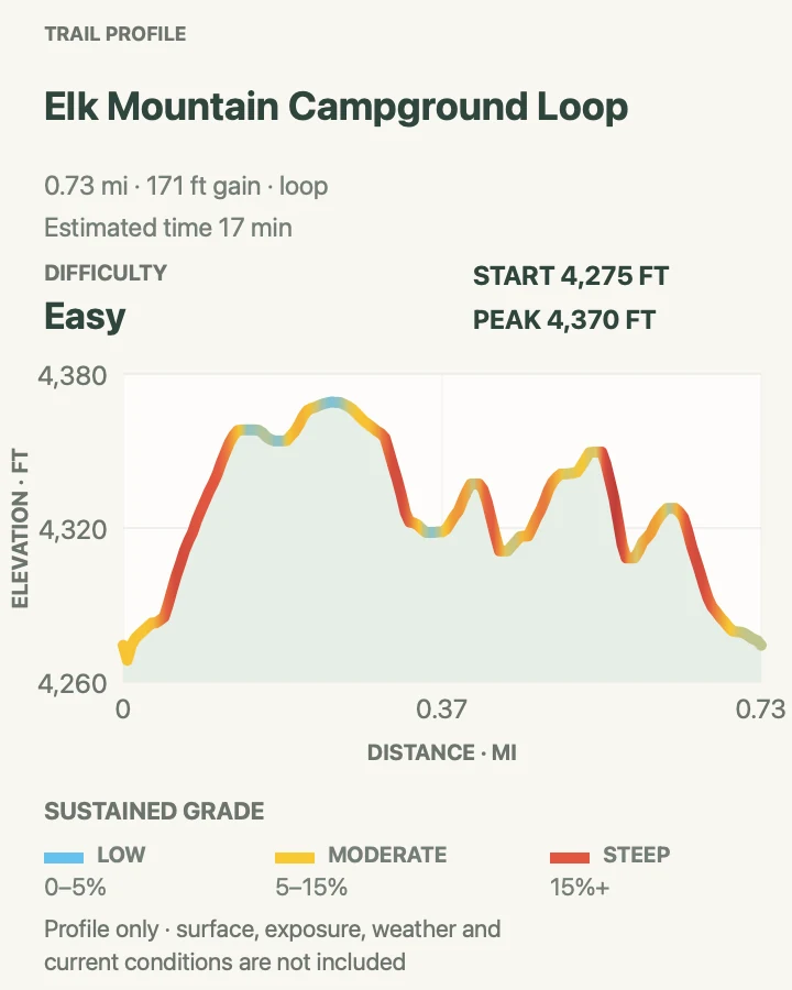
| Elk Mountain Campground Loop | About 0.7 mile on the reviewed loop; NPS rounds the outing to 1 mile | 17 min | Easy | A short campground walk through the meeting place of prairie and ponderosa forest |
Lookout Point and Centennial Trail Loop
- Distance
- About 4.8 miles on the reviewed loop
- Elevation gain
- 540 feet
- Time
- 2 hr 30 min
- Difficulty
- Moderate
- Route type
- Loop
- Parking
- Use the signed Lookout Point trailhead on South Dakota Highway 87 north of the visitor center; park fully inside the designated area and watch for wildlife on the road.
- Best time
- Early morning in spring or fall, or before summer heat and thunderstorms build.
- Pets
- Pets are not permitted on this trail.
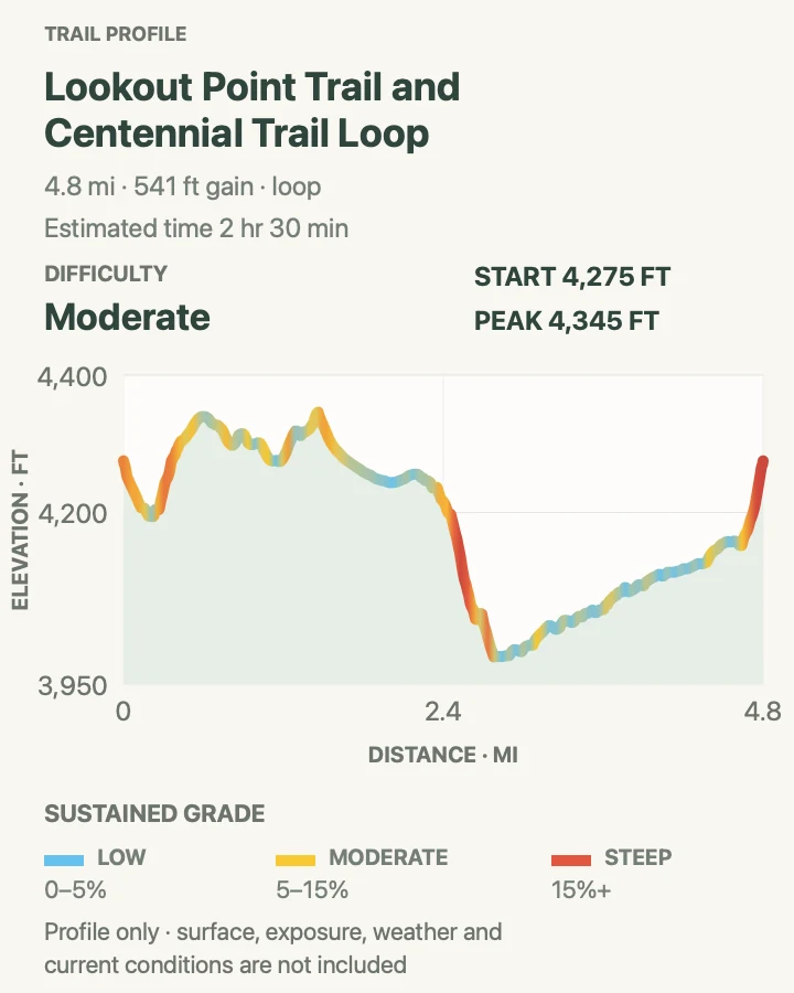
This is the all-rounder: enough distance to leave the roadside behind, but short enough to pair with a cave tour on a long summer day. The loop crosses open prairie on Lookout Point Trail, drops toward Beaver Creek, and returns on portions of the Centennial and Highland Creek trails. NPS describes a roughly 4.5-mile combination; the reviewed line measures about 4.8 miles.
The profile is deceptive at first glance because the highest ground is near the beginning. Most of the work comes from the abrupt descent into the drainage and the final climb back to the trailhead. There is little shelter on the open sections. If thunder is already audible, the broad prairie is the wrong place to wait and see what happens.
What helps on this route
- Carry the park trail map because several named routes meet on this loop.
- If bison occupy the creek crossing or return leg, give them room and reverse the loop rather than forcing a pass.
Terrain and access: Rolling mixed-grass prairie, creek-bottom trail, a few short steep grades, exposed sun, and multiple signed junctions.

Rankin Ridge Interpretive Trail
- Distance
- 1 mile round trip
- Elevation gain
- 270 feet
- Time
- 1 hr
- Difficulty
- Moderate
- Route type
- Loop
- Parking
- Follow the signed spur from South Dakota Highway 87. RVs and trailers are not permitted at the trailhead; a nearby pullout adds roughly 1,200 feet of walking.
- Best time
- A clear morning or late afternoon when distant Black Hills and Badlands views are least hazy.
- Pets
- Pets are not permitted on this trail.
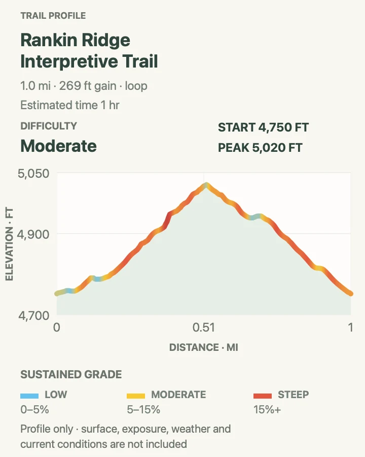
Rankin Ridge is brief but not flat. The loop climbs through ponderosa pine to the highest point in Wind Cave National Park, gaining roughly 270 feet in half a mile before returning by the other side of the ridge. Openings along the eastern edge can reach toward the Badlands when the air is clear.
The fire tower is closed to the public, so the reward is the ridge itself rather than a climb up the structure. The short mileage makes this a good weather-window hike, but the exposed upper section catches wind and storms. On the descent, loose gravel and pine needles deserve more attention than the easy one-mile label suggests.
What helps on this route
- Leave large vehicles at the signed pullout instead of testing the restricted trailhead road.
- Bring binoculars; the broad view is better for slow scanning than for a rushed summit photo.
Terrain and access: Ponderosa forest, open ridge, compact switchbacks, loose gravel, and a sustained climb over a short distance.

Cold Brook Canyon Trail
- Distance
- About 2.7 miles round trip on the reviewed track
- Elevation gain
- 210 feet
- Time
- 1 hr 30 min
- Difficulty
- Easy
- Route type
- Out and back
- Parking
- Use the signed gravel trailhead on US Highway 385 about one mile south of the visitor center.
- Best time
- Morning, when the canyon is cooler and raptors and prairie-dog activity are easier to watch.
- Pets
- Pets are not permitted on this trail.
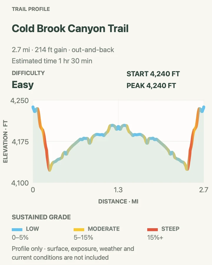
Cold Brook Canyon begins in ponderosa shade, then opens into grassland near a prairie dog town. That shift makes the route more interesting than its modest length suggests. NPS lists 1.4 miles one way to the park boundary; the reviewed out-and-back is about 2.7 miles, close to the same full outing.
Watch the sky as well as the burrows. Prairie falcons and other raptors work this open country, while bison may use the same canyon as an easy travel corridor. The correct response to an animal ahead is patience or a turnaround, not leaving the trail to squeeze past it.
What helps on this route
- Stay outside the prairie dog town and never feed wildlife.
- Check the return direction before the canyon opens; the broad grassland can make an obvious trail look less distinct.
Terrain and access: Gentle canyon trail, ponderosa forest, open grassland, prairie-dog habitat, and limited shade beyond the lower canyon.

Prairie Vista Loop
- Distance
- About 1 mile round trip
- Elevation gain
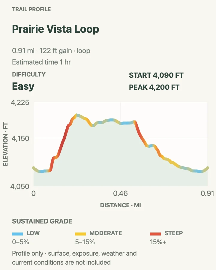
- 120 feet
- Time
- 1 hr
- Difficulty
- Easy
- Route type
- Loop
- Parking
- Begin at the visitor center or the picnic area roughly 1,000 feet north of it; use the established lots.
- Best time
- An early or late hour for softer light, or whenever a short walk must fit around a cave-tour time.
- Pets
- Leashed pets are permitted; use a leash no longer than six feet.
Prairie Vista is the useful short walk that many visitors skip while waiting for a cave tour. Waysides interpret the grassland, and the loop rises just enough above the visitor center to open a wider view across the hills. The reviewed line is 0.9 mile with about 120 feet of gain.
Being close to buildings does not turn it into a wildlife enclosure. Bison can move through the developed area, and rattlesnakes, ticks, heat, and fast-changing weather still belong to the same landscape found on longer routes. Keep children and pets close and use the loop as a real trail, not a paved waiting room.
What helps on this route
- If time is tight, start from the visitor center rather than trying to invent a roadside shortcut.
- Read the waysides in order; the interpretive stops are part of why this loop earns a place in the guide.
Terrain and access: Short grassland loop with interpretive waysides, gentle grades, a few sharper pitches, and broad weather exposure.

Boland Ridge Trail
- Distance
- About 4.9 miles round trip on the reviewed track
- Elevation gain
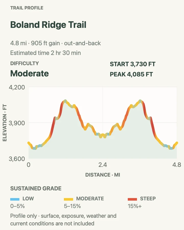
- 900 feet
- Time
- 2 hr 30 min
- Difficulty
- Moderate
- Route type
- Out and back
- Parking
- Use the small signed parking area on NPS Road 6, about one mile north of its junction with NPS Road 5.
- Best time
- Near sunrise or late afternoon for elk activity, with enough daylight for the rough access-road drive.
- Pets
- Pets are not permitted on this trail.
Boland Ridge sits away from the visitor-center cluster and feels correspondingly quieter. NPS lists 2.6 miles one way; the reviewed turnaround produces a 4.9-mile outing with about 900 feet of accumulated gain. The trail climbs in steps rather than making one steady ascent, repeatedly revealing a little more of Red Valley and the plains to the east.
Elk are often seen in the morning and evening, but that timing also puts wildlife on the gravel approach roads. Drive slowly and allow extra time to reach NPS Road 6. On foot, the ridge offers almost no protection from sun, wind, or lightning, so use the view as an early warning system rather than a reason to stay out too long.
What helps on this route
- Confirm the condition of NPS Roads 5 and 6 after heavy rain or winter weather.
- Turn around before the far ridge if a storm closes the gap to the Black Hills.
Terrain and access: Open prairie ridge, repeated short climbs, sparse shade, gravel-road access, and long exposed sightlines.

East Bison Flats Trail
- Distance
- About 10.1 miles round trip on the reviewed route
- Elevation gain
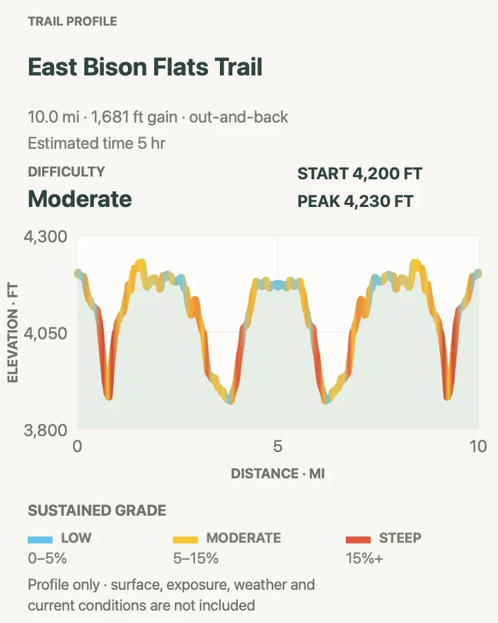
- 1,680 feet
- Time
- 5 hr
- Difficulty
- Moderate
- Route type
- Out and back
- Parking
- Use the signed southern trail access near US Highway 385 and Gobbler Ridge Road; follow current park signs rather than approaching through closed Wind Cave Canyon.
- Best time
- A cool, dry morning with a stable forecast and enough time to turn around for wildlife.
- Pets
- Pets are not permitted on this trail.
East Bison Flats is the long prairie day in this group. The reviewed GPS line runs about 10.1 miles round trip and repeatedly drops into shallow drainages before climbing back to the open flats. NPS describes a shorter 3.7-mile one-way trail segment, so do not assume its rounded mileage and this recorded turnaround are identical.
The name is a fair warning. Bison use these hills, and the long out-and-back gives them plenty of time to move between you and the trailhead. Carry enough water to wait or reroute only where park policy and visibility make that safe. Limited cell service, tall grass, and repeated drainage crossings make this a more consequential outing than the moderate grade suggests.
What helps on this route
- Set a turnaround time before starting; there is no single summit that announces the halfway point.
- Avoid the Wind Cave Canyon connection while the official closure remains active.
Terrain and access: Long exposed prairie, repeated drainage descents, tall grass, wildlife corridors, limited water, and little reliable shade.

Centennial Trail: Highland Creek to Badger Hole
- Distance
- About 13.3 miles one way
- Elevation gain
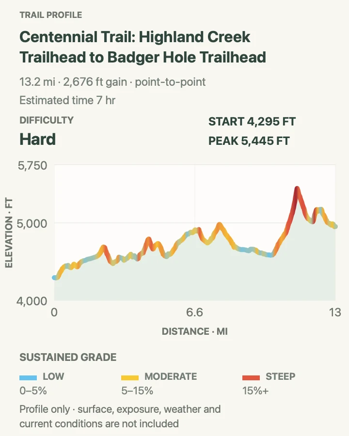
- 2,680 feet
- Time
- 7 hr
- Difficulty
- Hard
- Route type
- Point to point
- Parking
- Stage one vehicle at each confirmed trailhead or book a Black Hills shuttle. Check both Wind Cave and Custer State Park access rules before the hike.
- Best time
- A long, stable-weather day in late spring or fall, after transport and parking are arranged.
- Pets
- Pets are not permitted on the Wind Cave backcountry portion; check adjoining-land rules as well.
This is not simply a longer Wind Cave loop. The route starts at Highland Creek, follows the Centennial Trail north, and continues into Custer State Park toward Badger Hole. Wind Cave's official Centennial section is six miles within a 111-mile regional trail; this reviewed point-to-point covers about 13.3 miles and gains roughly 2,700 feet along the way.
The logistics deserve the same attention as the profile. Arrange the shuttle first, confirm that both endpoints are open, and do not plan to solve the return by parking overnight without authorization. The current NPS alert specifically notes that overnight parking requires a camping permit and that permits are not issued merely for parking.
What helps on this route
- Carry maps for both Wind Cave and Custer State Park; the route leaves the national park.
- Leave the itinerary, vehicle descriptions, and overdue time with someone who is not on the hike.
Terrain and access: Long point-to-point trail through prairie, ponderosa forest, creek corridors, road crossings, repeated climbs, and multiple jurisdictions.

Elk Mountain Campground Loop
- Distance
- About 0.7 mile on the reviewed loop; NPS rounds the outing to 1 mile
- Elevation gain
- 170 feet
- Time
- 17 min
- Difficulty
- Easy
- Route type
- Loop
- Parking
- Park within Elk Mountain Campground and begin across from the amphitheater without occupying a campsite assigned to another visitor.
- Best time
- Dawn or dusk in September and October, when elk may be heard bugling.
- Pets
- Leashed pets are permitted; use a leash no longer than six feet.
Elk Mountain is not a consolation prize for hikers without half a day. The little loop shows the seam between forest and grassland, and its campground location makes it practical before breakfast, after dinner, or while a longer group reorganizes. NPS rounds it to one mile; the reviewed line is about 0.7 mile.
September and October bring the possibility of elk bugling at dawn and dusk. Listen from a distance rather than following sound into the trees, particularly in low light. Even on this short route, keep pets close, scan for bison, and use a light if the walk begins or ends near darkness.
What helps on this route
- Do not cut through occupied campsites to shorten the loop.
- A headlamp is useful at dawn or dusk, but do not shine it at wildlife.
Terrain and access: Short campground nature trail through grassland and ponderosa forest with gentle grades and nearby wildlife habitat.

Official planning sources
Trail access and safety details were checked against these National Park Service pages. The maps and profiles use the reviewed route geometry stored with this guide.
- NPS: Wind Cave hiking trails and preparation
- NPS: Current Wind Cave alerts and conditions
- NPS: Wind Cave trail and road repair closure notice
- NPS: Hiking and wildlife safety
- NPS: Wind Cave pet rules
- NPS: Operating hours, seasons, and surface access
- NPS: Cave tour planning
- NPS: Wind Cave bison safety and behavior
Map data © OpenStreetMap contributors. Trail geometry and planning details include National Park Service public information.