11 Best Hikes in Capitol Reef National Park
Eleven Capitol Reef hikes through Fruita, Grand Wash, Sulphur Creek, and the Waterpocket Fold, with reviewed maps, elevation profiles, and live park alerts.
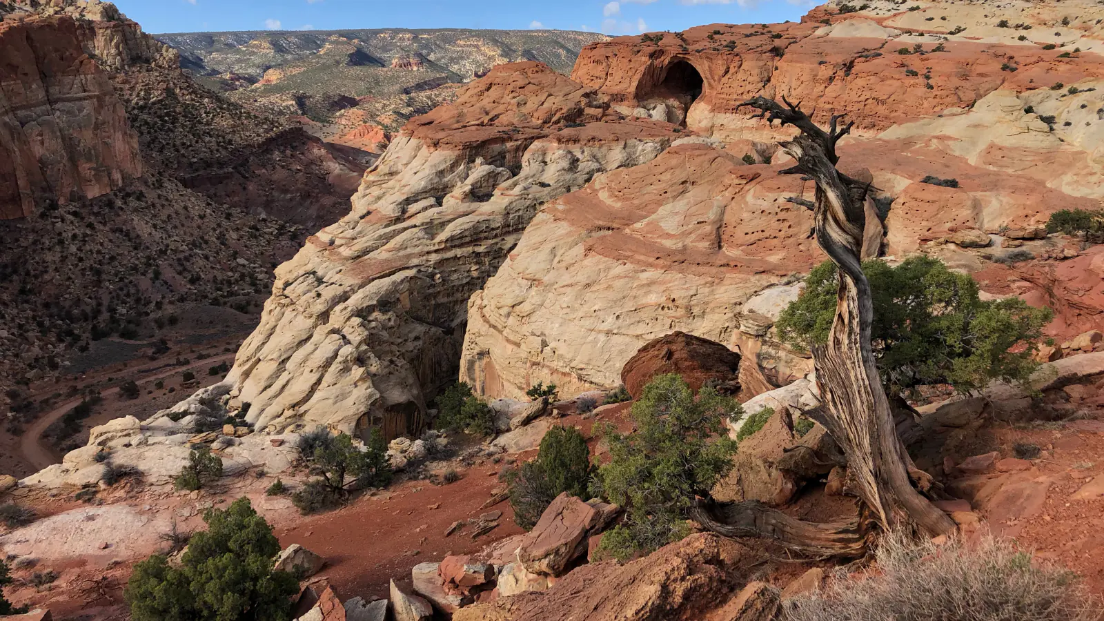
Capitol Reef is long, narrow, and divided by access. Fruita holds the visitor center, orchards, and the densest group of signed trails. Highway 24 reaches good trailheads on either side, while the southern Waterpocket and northern Cathedral districts demand more driving and more road judgment. This guide stays with eleven routes that can be described honestly from the reviewed map files.
The list is unranked because the useful comparison is terrain. Grand Wash is a level canyon walk; Rim Overlook is a hard climb; Cassidy Arch mixes switchbacks and open slickrock; Lower Spring Canyon needs a shuttle. A half-mile sunset stroll and a six-hour canyon traverse answer different questions.
Road and flood conditions take precedence over the itinerary. As of late August 2026 the park is open, Scenic Drive and Grand Wash Road are listed for ordinary two-wheel-drive vehicles, and Capitol Gorge Road is closed. Monsoon runoff can reverse those facts within minutes, so use the live alert panel before entering any wash.
What changes a hiking day here
Parking sets the start time
Popular Fruita and Highway 24 trailheads often fill by 9 a.m. and remain busy until late afternoon. A dawn start solves both heat and parking. Do not create a shoulder space where signs or soft ground rule it out.
A clear sky above you is not enough
Flash floods can arrive from storms miles upstream. Grand Wash, Sulphur Creek, Lower Spring Canyon, and every narrow drainage require a forecast for the whole watershed. Leave immediately if water rises, turns muddy, carries debris, or if thunder develops.
Desert water holes are habitat
Tanks, tinajas, and potholes support wildlife. Do not swim, wash, or step into them, and never plan to drink from them. Carry the full water supply; trailheads do not provide it.
Cairns are not collectibles
Some slickrock sections use rock cairns. Follow official markers but do not build, move, or add stacks, which can misdirect later hikers. Pets are not allowed on park trails or in the backcountry.
| Trail | Distance | Time | Difficulty | Best for |
|---|---|---|---|---|
| Sunset Point | 0.8 mi | 1 hr | Easy | A short panorama after a longer driving day |
| Chimney Rock Loop | 3.6 mi | 2 hr 30 min | Moderate | A compact high view of the Waterpocket Fold |
| Lower Sulphur Creek Waterfall Walk | 1.6 mi | 1 hr | Easy | A short introduction to creek walking |
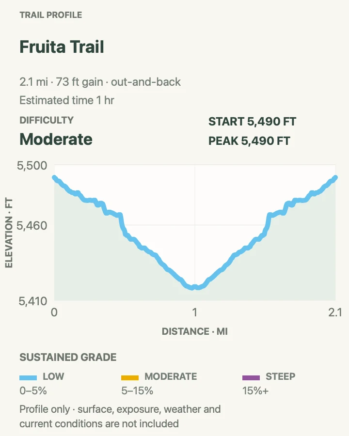
| Fruita Trail | 2.1 mi | 1 hr | Moderate | A short climb above the orchards |
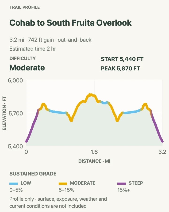
| Cohab Canyon to South Fruita Overlook | 3.3 mi | 2 hr | Moderate | Hidden side canyons and an elevated view over Fruita |
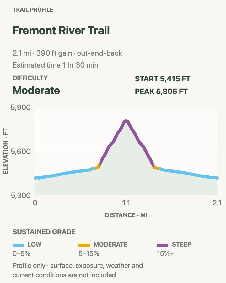
| Fremont River Trail | 2.2 mi | 1 hr 30 min | Moderate | A river stroll followed by a sharp viewpoint climb |
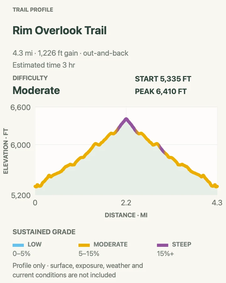
| Rim Overlook Trail | 4.4 mi | 3 hr | Moderate | A hard climb to the strongest Fruita overlook |
| Cassidy Arch Trail | 3.3 mi | 2 hr 5 min | Moderate | Slickrock travel to a large natural arch |
| Grand Wash from Highway 24 | 4.9 mi | 2 hr | Moderate | A level walk through tall canyon narrows |
| Lower Spring Canyon | 10.5 mi | 6 hr 6 min | Moderate | A long point-to-point canyon day |
| Frying Pan and Grand Wash Traverse | 7.1 mi | 4 hr 30 min | Hard | A strenuous ridge-to-canyon traverse |
Sunset Point
- Distance
- 0.8 mi
- Elevation gain
- 65 feet
- Time
- 1 hr
- Difficulty
- Easy
- Route type
- out-and-back
- Parking
- Take the Goosenecks spur from Highway 24 and use the signed Sunset Point parking area when the dirt road is open.
- Best time
- The final hour before sunset, with a headlamp for the walk back.
- Pets
- Pets are not allowed on park trails. Trained service animals are allowed.
Sunset Point crosses an open bench to a broad view over the Fremont River corridor and the western edge of the Waterpocket Fold. The path is short enough for an arrival evening but far enough from the car to lose the roadside feel.
Low sun throws more shape across the tilted rock layers. The return is easy to underestimate after stopping for color, so carry a light and leave the rim before the path disappears into dusk.
What helps on this route
- Check the Goosenecks road after heavy rain; dry-weather passenger-car access can change quickly.
- Bring a wind layer even on a warm day because the point is fully exposed.
Terrain and access: Short sandy path, mild grades, open slickrock, unguarded rim, full sun, and possible wind.

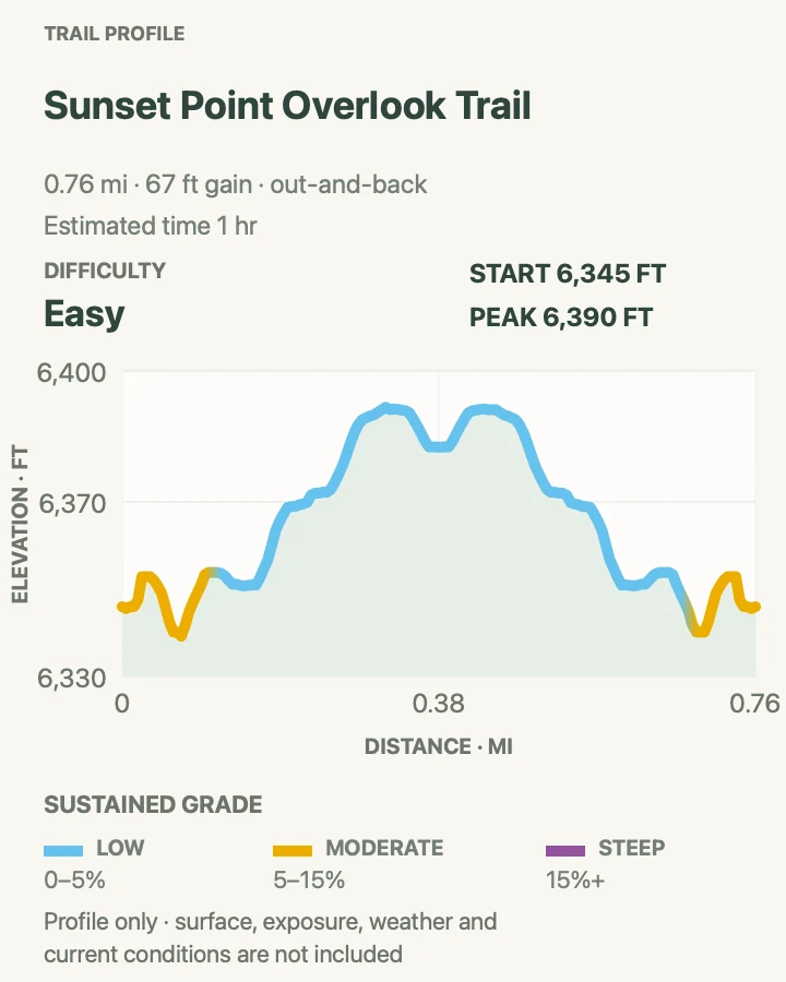
Chimney Rock Loop
- Distance
- 3.6 mi
- Elevation gain
- 830 feet
- Time
- 2 hr 30 min
- Difficulty
- Moderate
- Route type
- loop
- Parking
- Use the signed Highway 24 trailhead west of the visitor center; the lot is small.
- Best time
- Sunrise or late afternoon in cooler weather, avoiding exposed midday heat.
- Pets
- Pets are not allowed on park trails. Trained service animals are allowed.
Chimney Rock starts with the day's steepest work, climbing switchbacks above the highway before circling a high bench behind the formation. Once on top, the loop rolls past views into Spring Canyon and across the Fold's striped cliffs.
The quick initial gain and loose surface make the official strenuous rating fair. There is almost no shade, and the west-facing return holds heat. Sunset is excellent only if everyone has a headlamp and knows the final switchbacks.
What helps on this route
- Complete the loop clockwise if you prefer to climb the steepest switchbacks while fresh.
- Do not remain on the open bench when thunder approaches.
Terrain and access: Steep sandy switchbacks, open bench, loose rock, cliff-edge views, minimal shade, and rolling return.

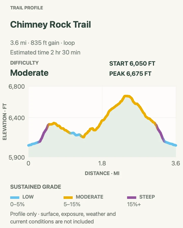
Lower Sulphur Creek Waterfall Walk
- Distance
- 1.6 mi
- Elevation gain
- 100 feet
- Time
- 1 hr
- Difficulty
- Easy
- Route type
- out-and-back
- Parking
- Begin near the Capitol Reef Visitor Center and use only the lower creek corridor represented on the map.
- Best time
- A warm but not hot dry morning with no rain anywhere in the drainage.
- Pets
- Pets are not allowed on park trails. Trained service animals are allowed.
This lower out-and-back samples Sulphur Creek and one of its small falls without claiming to be the full point-to-point canyon route. Expect wet feet, polished rock, and frequent decisions about the easiest line beside or through shallow water.
Creek depth varies. The longer NPS route includes three waterfalls, deeper water, and a shuttle; it is a different undertaking. Never enter when storms threaten, and turn around when flow exceeds the ability of the least experienced person.
What helps on this route
- Use shoes that drain and grip wet sandstone rather than flip-flops.
- Leave the creek before water darkens, rises, or begins carrying twigs and foam.
Terrain and access: Shallow water, slick bedrock, gravel bars, small ledges, canyon walls, and no escape during a flood.

Fruita Trail
- Distance
- 2.1 mi
- Elevation gain
- 75 feet
- Time
- 1 hr
- Difficulty
- Moderate
- Route type
- out-and-back
- Parking
- Start in the Fruita historic district near the visitor center and use designated public parking rather than campground sites.
- Best time
- Early morning in spring or fall, or during orchard season before midday heat.
- Pets
- Pets are not allowed on park trails. Trained service animals are allowed.
Fruita Trail rises from the green river corridor into dry pinyon-juniper country, quickly changing the view from orchard rows to the cliffs enclosing the historic district. It is a useful bridge between the human history at ground level and the geology above it.
The climb is exposed and more sustained than the distance implies. Orchard harvest rules apply below: enter only orchards posted open, use the provided scales, and do not disturb fruit or research markers outside the designated area.
What helps on this route
- Walk the trail before visiting the orchards so carried fruit does not become extra weight on the climb.
- Give campground roads and occupied sites their privacy when reaching the trail access.
Terrain and access: Dry rocky climb, pinyon-juniper, open slopes, views over orchards, little shade, and loose descent.

Cohab Canyon to South Fruita Overlook
- Distance
- 3.3 mi
- Elevation gain
- 740 feet
- Time
- 2 hr
- Difficulty
- Moderate
- Route type
- out-and-back
- Parking
- Use the Cohab Canyon trailhead opposite the Fruita Campground; do not occupy a campsite parking pad.
- Best time
- Morning, when the opening switchbacks are cooler and the overlook light is clearer.
- Pets
- Pets are not allowed on park trails. Trained service animals are allowed.
Cohab Canyon climbs steeply from the Fremont River, then slips into a narrow sandstone corridor cut by small slots and alcoves. The South Fruita spur leaves the main trail for a high view over the orchards and campground.
This out-and-back turns at the overlook instead of continuing across the full Cohab route. Several spur paths and slickrock markers make the map useful. Avoid climbing into side slots when runoff or thunder is possible.
What helps on this route
- Save a mental picture of the overlook junction for the return.
- Start before campground traffic and sun reach the exposed opening switchbacks.
Terrain and access: Steep switchbacks, sandy canyon floor, slickrock spurs, small slots, exposed overlook, and minimal water.

Fremont River Trail
- Distance
- 2.2 mi
- Elevation gain
- 390 feet
- Time
- 1 hr 30 min
- Difficulty
- Moderate
- Route type
- out-and-back
- Parking
- Begin near the Fremont River crossing in Fruita, using signed day-use parking.
- Best time
- Early morning or evening outside high heat and thunderstorm periods.
- Pets
- Pets are not allowed on park trails. Trained service animals are allowed.
The first part follows the Fremont River through cottonwoods and orchard-edge shade. Then the trail turns uphill and climbs hard to an open bench above the valley, where the Fold and Fruita spread out below.
Families can enjoy the flat river section and turn around before the grade changes. Anyone continuing should expect loose footing and full sun. The upper viewpoint is exposed to wind and lightning.
What helps on this route
- Decide at the base of the climb whether the heat and group energy justify the upper section.
- Keep food close; deer and other wildlife regularly use the river corridor.
Terrain and access: Level riverside path, cottonwood shade, abrupt sandy climb, exposed bench, loose rock, and steep return.

Rim Overlook Trail
- Distance
- 4.4 mi
- Elevation gain
- 1,230 feet
- Time
- 3 hr
- Difficulty
- Moderate
- Route type
- out-and-back
- Parking
- Use the Hickman Bridge/Rim Overlook trailhead on Highway 24; arrive early because the lot is small and busy.
- Best time
- A cool morning with a stable forecast and clear visibility.
- Pets
- Pets are not allowed on park trails. Trained service animals are allowed.
Rim Overlook shares the first stretch with Hickman Bridge before climbing steadily above the Fremont River. The finish stands on cliffs roughly a thousand feet over Fruita, with the orchards, campground, Highway 24, and Fold visible in one sweep.
The elevation gain is concentrated and largely unshaded. Navajo Knobs continues far beyond the overlook, but that extension nearly doubles the mileage and deserves its own plan. Turn around at the mapped objective.
What helps on this route
- Carry more water than the river view suggests; there is no trail water to use.
- Do not edge closer for a photograph—the final cliffs have no railing.
Terrain and access: Sustained slickrock and dirt climb, cairned route, exposed cliffs, loose steps, no shade, and steep descent.

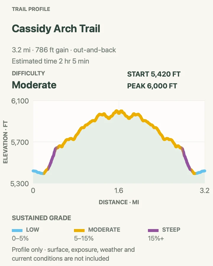
Cassidy Arch Trail
- Distance
- 3.3 mi
- Elevation gain
- 790 feet
- Time
- 2 hr 5 min
- Difficulty
- Moderate
- Route type
- out-and-back
- Parking
- Drive Grand Wash Road to its signed parking area only when the road is open and suitable for the vehicle.
- Best time
- Early morning, before Grand Wash heats up and parking fills.
- Pets
- Pets are not allowed on park trails. Trained service animals are allowed.
Cassidy Arch begins on the floor of Grand Wash, then climbs sharply through ledges to an open slickrock bench. The final approach looks across the top of the arch rather than through it from below, with Grand Wash dropping away beyond.
Cairns guide the broad rock surface, but they can be missed on the return. Standing on the arch is legal only where the official trail leads, yet the edges remain exposed and sandstone can be slick after rain or frost.
What helps on this route
- Photograph the cairn line on the outward crossing to simplify the return.
- Check Grand Wash Road after storms and do not drive around a closure sign.
Terrain and access: Wash floor, steep switchbacks, rock ledges, cairned slickrock, exposed arch top, and little shade.

Grand Wash from Highway 24
- Distance
- 4.9 mi
- Elevation gain
- 290 feet
- Time
- 2 hr
- Difficulty
- Moderate
- Route type
- out-and-back
- Parking
- Use the signed Highway 24 trailhead at the northeast mouth; do not block the highway shoulder.
- Best time
- A dry morning in spring or fall with no storms in the watershed.
- Pets
- Pets are not allowed on park trails. Trained service animals are allowed.
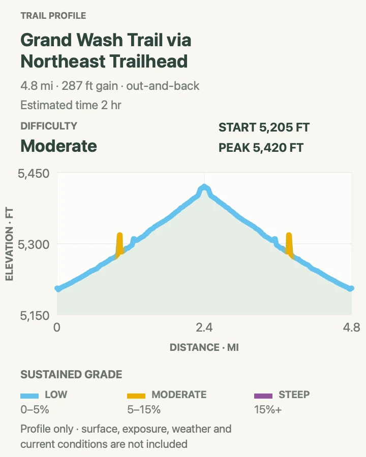
Grand Wash enters between sheer Wingate walls and reaches a narrows section where the canyon floor tightens while the cliffs rise overhead. Starting from Highway 24 avoids relying on Grand Wash Road and makes a simple out-and-back.
The walking is easy; the flood exposure is not. There is no safe place to be in the narrows when runoff arrives. Deep sand also slows the return more than the flat profile suggests.
What helps on this route
- Skip the hike if rain is possible anywhere upstream, not only at the trailhead.
- Turn around at a preselected time so heat and soft sand do not consume the reserve.
Terrain and access: Broad gravel wash, deep sand, towering narrows, minimal grade, no shade, and severe flash-flood exposure.

Lower Spring Canyon
- Distance
- 10.5 mi
- Elevation gain
- 400 feet
- Time
- 6 hr 6 min
- Difficulty
- Moderate
- Route type
- point-to-point
- Parking
- Arrange a legal two-car shuttle between the Chimney Rock trailhead and the Highway 24 exit near the Fremont River; never walk the highway tunnel.
- Best time
- A cool, completely dry day with ample daylight and two reliable vehicles.
- Pets
- Pets are not allowed on park trails. Trained service animals are allowed.
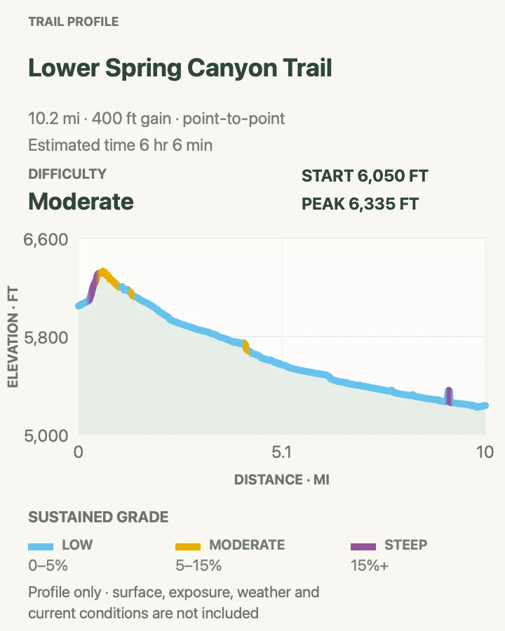
Lower Spring Canyon leaves the Chimney Rock area, drops through open benches, and spends miles inside a deep canyon before meeting the Fremont River corridor. The scale changes gradually from broad Fold views to enclosed walls and cottonwood pockets.
The route depends on a shuttle and flood-safe weather. Water may be present but is not dependable or automatically safe. The Highway 24 finish has traffic and limited space; set the vehicle plan before anyone starts walking.
What helps on this route
- Leave a written shuttle plan with both drivers and carry keys for both vehicles if possible.
- Treat every water source and carry enough to finish if the canyon is dry.
Terrain and access: Long point-to-point route, steep initial descent, sandy canyon, brush, boulders, possible water, and remote exit.

Frying Pan and Grand Wash Traverse
- Distance
- 7.1 mi
- Elevation gain
- 1,620 feet
- Time
- 4 hr 30 min
- Difficulty
- Hard
- Route type
- point-to-point
- Parking
- Use two vehicles between the Cohab Canyon/Fruita side and Grand Wash, confirming the wash road and parking plan before departure.
- Best time
- A cool, dry day with no monsoon risk and enough daylight for a slow slickrock crossing.
- Pets
- Pets are not allowed on park trails. Trained service animals are allowed.
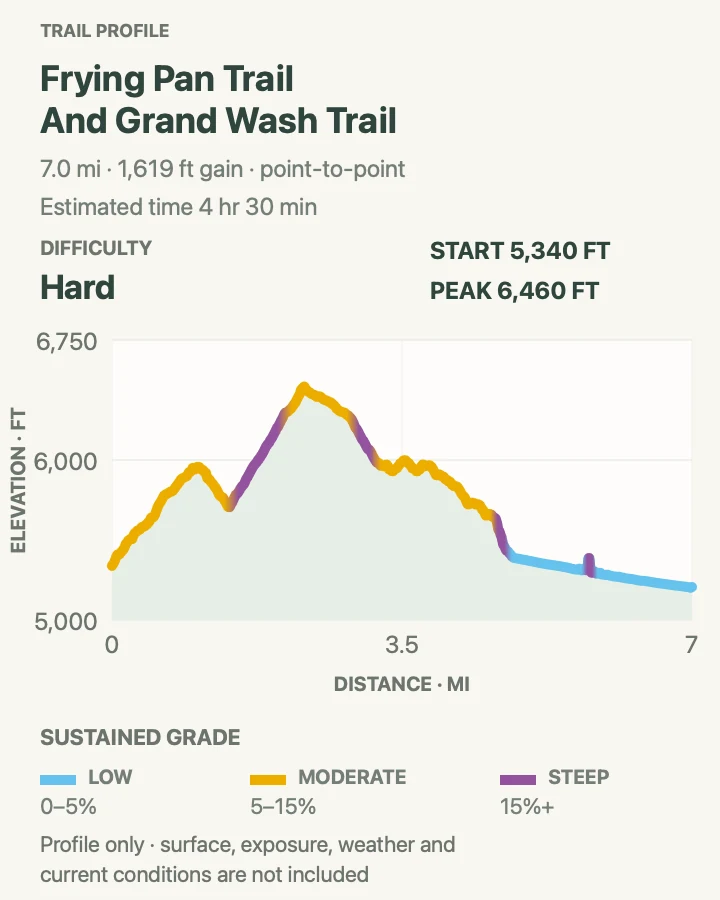
Frying Pan crosses high slickrock between Cohab Canyon and Cassidy Arch, then drops to Grand Wash. It links hidden canyons, exposed ridges, arch country, and a shaded narrows in one demanding line.
The route is harder to follow than the signed Fruita day hikes. Cairns can be sparse across bare rock, heat is amplified on the ridges, and both endpoints must remain accessible. Use the map as a supplement to current NPS directions, not as permission to improvise.
What helps on this route
- Confirm both shuttle vehicles are parked outside any gate that could close during the day.
- Carry offline navigation and turn back before a missed cairn becomes a late-day problem.
Terrain and access: Cairned slickrock, steep ledges, exposed ridges, sandy canyon, route-finding, no water, and substantial shuttle logistics.

Official planning sources
Trail access and safety details were checked against these National Park Service pages. The maps and profiles use the reviewed route geometry stored with this guide.
Map data © OpenStreetMap contributors. Trail geometry and planning details include National Park Service public information.