7 Best Hikes in Black Canyon of the Gunnison National Park
Seven Black Canyon hikes on the South Rim, North Rim, and permitted inner-canyon routes, with reviewed maps, elevation profiles, and current park alerts.
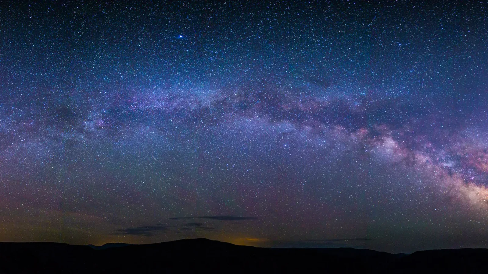
Black Canyon is a park of two rims and one difficult interior. The South Rim has the visitor center, the main scenic road, and the largest share of short walks. The North Rim is quieter and reached by a separate drive. There is no bridge across the canyon inside the park, so a route on the opposite rim is a different day, not a quick addition.
The two inner-canyon entries here are not maintained trails. They are steep, loose wilderness routes where a two-mile round trip can consume most of a day. Both require permits, and the Gunnison Route now crosses terrain affected by the 2025 South Rim Fire. They belong at the end of this guide because they are specialist undertakings, not harder versions of a rim hike.
Distances and profiles below come from the reviewed route files. Roads, burned-area hazards, and seasonal services change, so check the live park feed before driving out. As of August 2026, South Rim and North Rim roads are open, East Portal Road is closed until further notice after flood damage, and several South Rim paths cross burned ground.
What changes a hiking day here
Choose a rim before choosing a trail
The South Rim is reached from Montrose on CO 347; the North Rim is reached from near Crawford. Driving between them takes hours outside the park. North Rim Road is unpaved and closes to vehicles in winter, while South Rim Road normally closes beyond the visitor center from roughly mid-November into spring.
Fire changed the South Rim
The 2025 South Rim Fire left unstable slopes, burned trees, ash, and rough tread. Current reports list Rim Rock and Uplands open but passing through heavily burned ground. The Gunnison Route carries more serious burned-area hazards. A route being open does not make it unchanged.
Inner-canyon permits are route reservations
Every inner-canyon day trip and overnight requires a wilderness permit. For the 2026 main season, South Rim routes and Red Rock Canyon use advance reservations on Recreation.gov; off-season permits use the park's same-day process. Group size is limited to four. Carry water, a waste bag, and enough equipment to survive an unplanned night.
High rims create mountain weather
Most rim trailheads sit near 8,000 feet. Sun, wind, hail, and lightning can arrive in the same afternoon, and drinking water is unavailable from late fall into mid-spring. Many paths run beside unguarded drops. Keep children close, and never throw stones into the canyon.
| Trail | Distance | Time | Difficulty | Best for |
|---|---|---|---|---|
| Uplands and Rim Rock Loop | 3 mi | 1 hr 23 min | Moderate | An easy-to-moderate South Rim introduction |
| Oak Flat Loop Trail | 1.5 mi | 47 min | Moderate | The best short South Rim hike below the rim edge |
| Painted Wall View | 0.2 mi | 1 hr | Easy | A brief walk to the park's signature cliff |
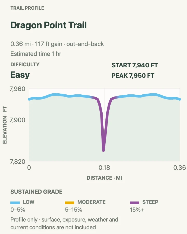
| Dragon Point | 0.4 mi | 1 hr | Easy | A short western-rim walk with a broad canyon angle |
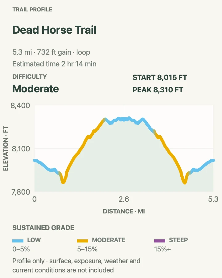
| Deadhorse Trail | 5.3 mi | 2 hr 14 min | Moderate | A quiet North Rim half-day away from the main overlooks |
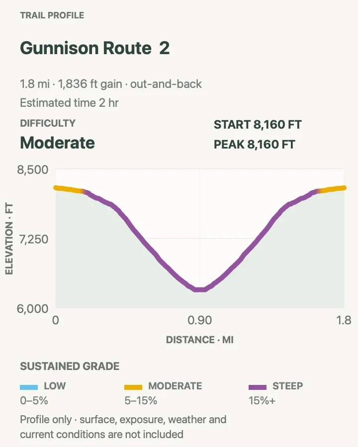
| Gunnison Route | 2 mi | 2 hr | Moderate | Experienced inner-canyon hikers prepared for loose, unmarked terrain |
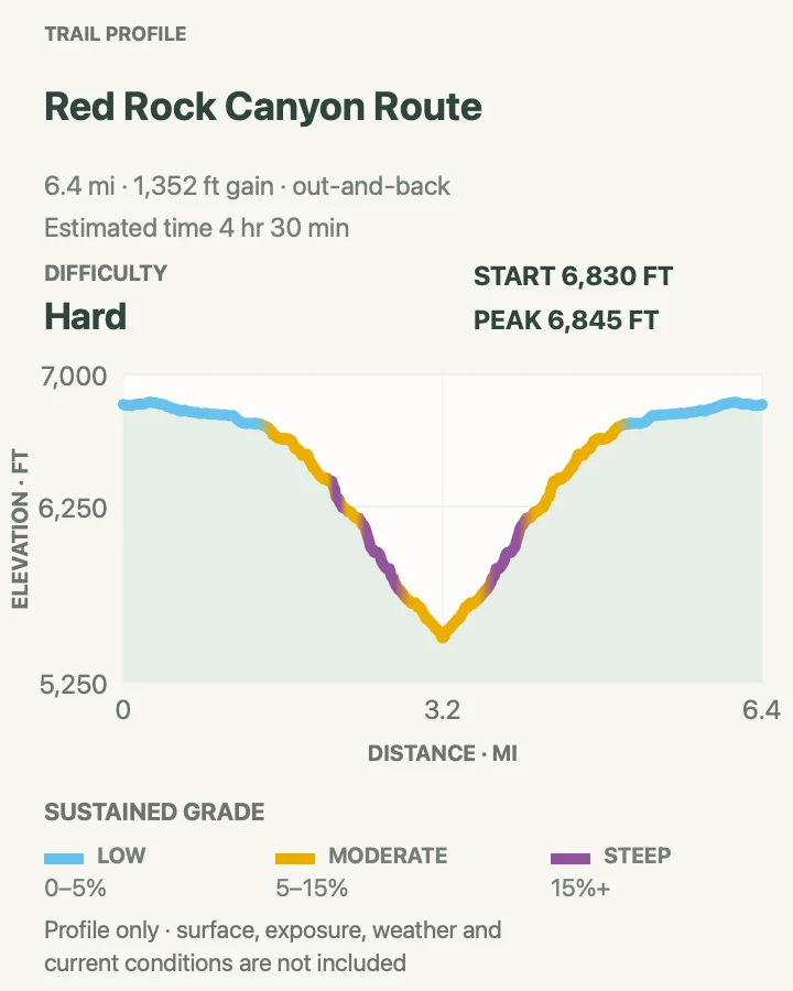
| Red Rock Canyon Route | 6.5 mi | 4 hr 30 min | Hard | A longer inner-canyon route with less extreme grades |
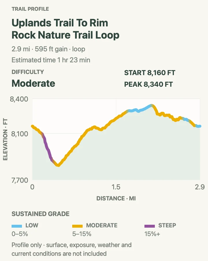
Uplands and Rim Rock Loop
- Distance
- 3 mi
- Elevation gain
- 600 feet
- Time
- 1 hr 23 min
- Difficulty
- Moderate
- Route type
- loop
- Parking
- Use the South Rim Visitor Center and join Uplands with Rim Rock and the upper Oak Flat connector.
- Best time
- Morning or late afternoon when the rim light is softer; check wind and burned-area conditions first.
- Pets
- Pets are not allowed on park trails. Trained service animals are allowed.
This circuit links Rim Rock's canyon-edge views with the scrub oak and sage of Uplands, using the upper Oak Flat connector to close the loop. The changes in habitat make it more satisfying than walking Rim Rock out and back, though several signed junctions require attention.
The 2025 fire burned much of the Uplands and Rim Rock corridor. Both trails are open, though ash, uneven surfaces, and newly exposed ground may be present. Pets are allowed on Rim Rock alone, not on this complete loop.
What helps on this route
- Start at the visitor center if you want current trail advice before setting out, and photograph the junction map.
- Do not step past the maintained tread for a cleaner photograph; several edges are abrupt and unguarded.
Terrain and access: Rocky rim path, scrub oak, uneven steps, exposed drop-offs, open burned ground, sparse shade, and several junctions.

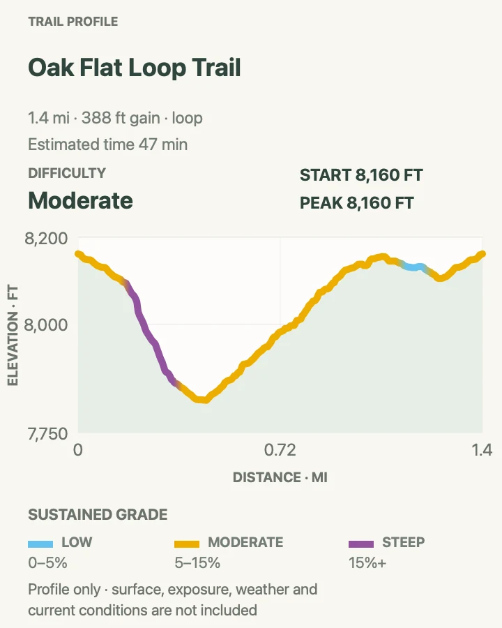
Oak Flat Loop Trail
- Distance
- 1.5 mi
- Elevation gain
- 390 feet
- Time
- 47 min
- Difficulty
- Moderate
- Route type
- loop
- Parking
- Start beside the South Rim Visitor Center and follow the signed loop junction below the rim.
- Best time
- A dry morning from late spring through fall; snow and ice make the steep sections considerably harder.
- Pets
- Pets are not allowed on park trails. Trained service animals are allowed.
Oak Flat drops through Gambel oak, aspen, and Douglas-fir before climbing back to the visitor center. The roughly 400-foot descent changes the view and the vegetation quickly, while still staying above the inner canyon's technical routes.
Short does not mean casual here. Narrow sections traverse steep slopes, loose rock collects on the tread, and the climb back arrives at the end. A junction with the Gunnison Route is not an invitation to continue downward without the required permit and preparation.
What helps on this route
- Keep right at signed junctions if following the standard loop, and do not follow inner-canyon route markers by mistake.
- Use trekking poles only if they help on narrow, loose trail; they cannot replace careful footing.
Terrain and access: Steep dirt and rock trail, shaded woodland, narrow traverses, loose footing, steps, and an exposed final climb.

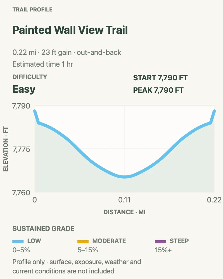
Painted Wall View
- Distance
- 0.2 mi
- Elevation gain
- 25 feet
- Time
- 1 hr
- Difficulty
- Easy
- Route type
- out-and-back
- Parking
- Use the signed Painted Wall View pullout on South Rim Road when the seasonal road is open.
- Best time
- Late afternoon, when angled light brings out the pale pegmatite bands across the canyon.
- Pets
- Pets are not allowed on park trails. Trained service animals are allowed.
This is a short overlook walk rather than a hike that fills the morning. Its value is the destination: a direct view of the 2,250-foot Painted Wall, the tallest cliff in Colorado, streaked by pale igneous bands.
Pair it with Oak Flat or Rim Rock instead of counting it as the day's mileage. The final overlook is developed, but the canyon depth and gusting rim winds still deserve attention, especially with small children.
What helps on this route
- Use the viewpoint as one deliberate stop on South Rim Road rather than trying to walk every tiny spur.
- Bring a longer lens or binoculars to inspect the rock bands across the gorge.
Terrain and access: Very short developed path, mild grade, exposed overlook, little shade, and possible strong wind.

Dragon Point
- Distance
- 0.4 mi
- Elevation gain
- 120 feet
- Time
- 1 hr
- Difficulty
- Easy
- Route type
- out-and-back
- Parking
- Use the signed Dragon Point pullout near the west end of South Rim Road when the seasonal road is open.
- Best time
- Late afternoon, leaving enough daylight for the drive back along South Rim Road.
- Pets
- Pets are not allowed on park trails. Trained service animals are allowed.
Dragon Point follows a short rocky spur to a western view of the gorge, with the river bends and distant San Juan Mountains appearing beyond the immediate canyon walls. It takes longer than its mileage suggests if you stop to read the rock and watch the light change.
This is still an overlook walk, not a stand-alone half-day. Combine it with Painted Wall and one of the South Rim loops. The short tread has uneven rock and an exposed finish, so ordinary shoes and careful footing matter more than the distance implies.
What helps on this route
- Stop here after Painted Wall to see how the canyon changes farther west.
- Leave before dusk unless you have a headlamp and are comfortable driving the winding rim road after dark.
Terrain and access: Short rocky spur, modest grades, open sun, little shade, and an unguarded canyon-edge viewpoint.

Deadhorse Trail
- Distance
- 5.3 mi
- Elevation gain
- 730 feet
- Time
- 2 hr 14 min
- Difficulty
- Moderate
- Route type
- loop
- Parking
- Use Kneeling Camel View near the east end of North Rim Road; leave room for stock trailers.
- Best time
- A cool, dry morning while North Rim Road is open.
- Pets
- Pets are not allowed on park trails. Trained service animals are allowed.
Deadhorse begins on an old service road, passes a usually dry stock pond, and continues to the rim above Deadhorse Gulch and East Portal. The walking is less dramatic at first than North Vista, then pays off with a broad view into the eastern canyon.
It is the park's only trail open to horses and pack animals. Hikers should yield, speak calmly when approaching stock, and leave gates as found. The route has little water or shade and feels remote despite its moderate grade.
What helps on this route
- Carry enough water for the full out-and-back; the stock pond is not a drinking source.
- Step to the downhill side only when a rider directs you; otherwise ask where they want you to wait.
Terrain and access: Old service road, open scrub, dry pond, fence-line walking, uneven rock, limited shade, and a canyon-rim finish.

Gunnison Route
- Distance
- 2 mi
- Elevation gain
- 1,840 feet
- Time
- 2 hr
- Difficulty
- Moderate
- Route type
- out-and-back
- Parking
- Start at the South Rim Visitor Center after obtaining the required wilderness permit and current route briefing.
- Best time
- Only in stable, dry weather, with a very early start and enough daylight for the ascent.
- Pets
- Pets are not allowed on park trails. Trained service animals are allowed.
Gunnison Route drops about 1,800 feet in roughly one mile from the South Rim to the river. A chain assists one especially steep section, but much of the descent is loose rock and improvised route-finding rather than constructed trail. The return climb is the harder half of the day.
The 2025 fire added unstable slopes, burned vegetation, falling-rock risk, and potentially hazardous trees. NPS limits access and requires a reserved permit in the main season. This route is not appropriate for anyone looking for a conventional strenuous hike, and a map line cannot convey its exposure.
What helps on this route
- Obtain the permit and ranger briefing before committing; do not descend on another group's reservation or follow them blindly.
- Wear a helmet, carry four quarts of water per person, and pack for an unexpected night.
Terrain and access: Unmarked wilderness route, extreme grade, loose scree, chain-assisted section, burned slopes, rockfall exposure, and a punishing ascent.

Red Rock Canyon Route
- Distance
- 6.5 mi
- Elevation gain
- 1,350 feet
- Time
- 4 hr 30 min
- Difficulty
- Hard
- Route type
- out-and-back
- Parking
- Use the signed Red Rock Canyon access west of the main South Rim entrance only with the required permit and current directions.
- Best time
- A cool, dry day with an early start; avoid rain, flash-flood risk, and hot summer afternoons.
- Pets
- Pets are not allowed on park trails. Trained service animals are allowed.
Red Rock Canyon follows a long drainage from the uplands to the Gunnison River. Its grade is generally less abrupt than the routes directly below the South Rim, but the additional mileage, route-finding, heat, and streambed travel make it a serious wilderness day.
A permit is required, with advance reservations used during the main season. Private-property boundaries and access instructions matter at this trailhead, so follow the current permit directions rather than an old track file. Mud, loose rock, poison ivy, and rising water can all slow the climb out.
What helps on this route
- Carry the current route sheet and stay within the authorized access corridor.
- Do not begin if rain could send water through the drainage or if the return will fall in the hottest part of the day.
Terrain and access: Unmarked drainage route, loose rock, brush, streambed travel, exposed sun, sustained descent and climb, and possible high water.

Official planning sources
Trail access and safety details were checked against these National Park Service pages. The maps and profiles use the reviewed route geometry stored with this guide.
Map data © OpenStreetMap contributors. Trail geometry and planning details include National Park Service public information.