5 Best Hikes and Walks in White Sands National Park
Five White Sands routes across dune edges, deep gypsum sand, a changing playa, and ranger-only Lake Lucero, with current access notes.
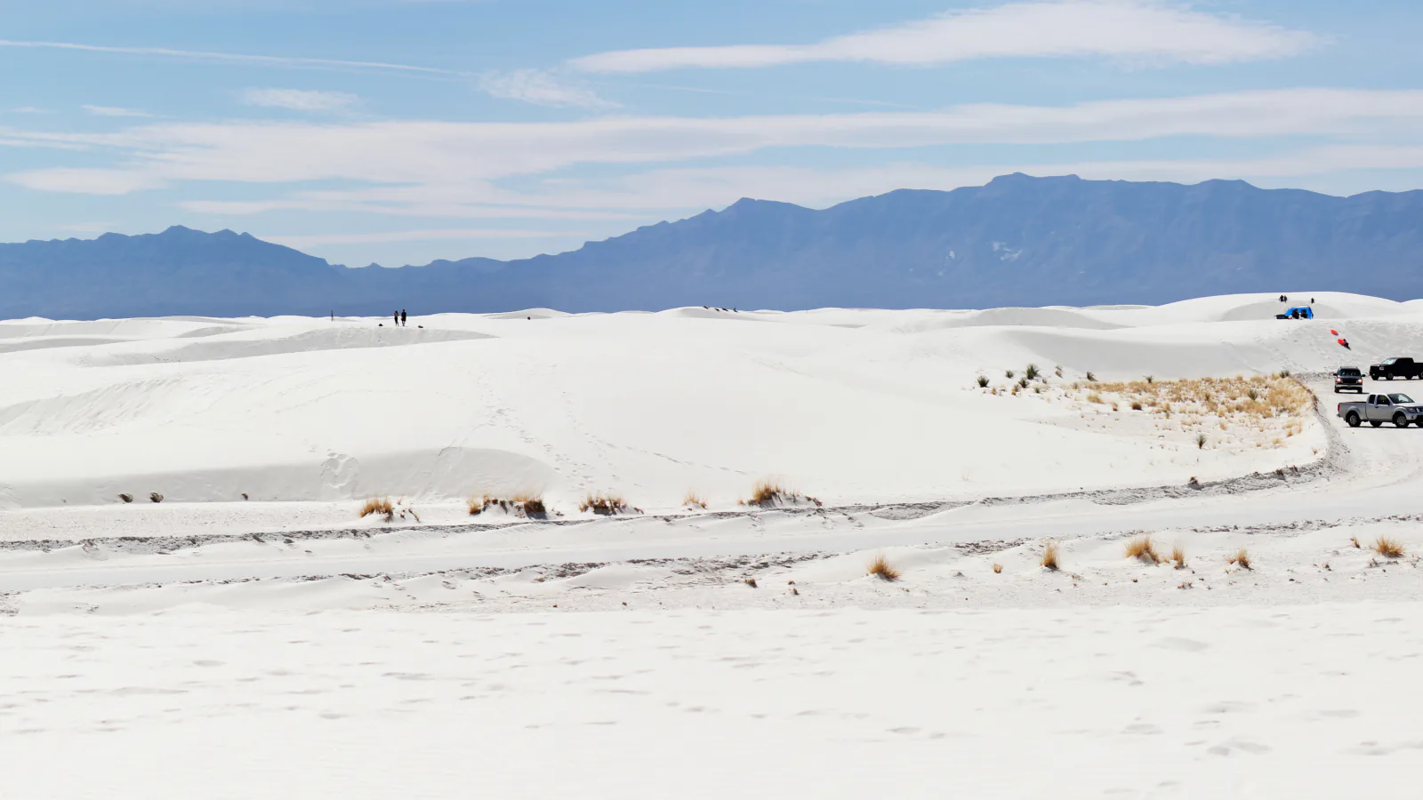
White Sands mileage is deceptive. A one-mile loop can mean repeated climbs in loose gypsum, and a five-mile route can erase its own footprints while you are still walking it. The grade profile helps, but trail posts, wind, heat, and turnaround discipline matter more than a neat line on a screen.
These five outings are arranged by what they teach, not by somebody else's popularity ranking. Dune Life begins where desert scrub meets the sand. Alkali Flat goes deep into the dunefield. Playa Trail explains a basin that changes color and texture, the Backcountry Loop delivers a shorter set of serious dune climbs, and Lake Lucero reaches the geologic source on a ranger-controlled visit.
The status check for this guide was made on August 29, 2026. A safety corridor remains in force between miles 3 and 5.5 of Dunes Drive: driving through is allowed, but stopping, parking, or leaving a vehicle is prohibited, and the Interdune Boardwalk is closed. Missile testing and weather can also shut the road. Read the park alert before driving in.
What changes a hiking day here
Turn around when the next post disappears
White Sands marks routes with colored posts and card-suit symbols. Wind can knock a post down or hide it in blowing sand. NPS gives an unusually firm instruction: if you cannot see the next marker, go back to the car. Tracks and phone GPS are poor substitutes in moving dunes.
Treat 85°F as a decision point
NPS advises against beginning a hike when the temperature is at or above 85°F. There is almost no shade, water is available only at the visitor center, and the white surface reflects sun from below. Carry one gallon per person per day, salty food, eye protection, and clothing that covers exposed skin.
Know when the gate closes
Park hours move with sunset, and summer closing time differs from the standard season. Dunes Drive can also close for missile tests. Check that day's hours and leave enough margin to be back at the vehicle before the gate, rather than planning from an old screenshot.
Pets need the same water margin
Leashed pets are allowed on these routes, with a maximum leash length of six feet. Carry their water, protect paws from hot surfaces, remove waste, and never leave an animal in the car. A sand loop that feels slow to a person is harder on a dog wearing a fur coat.
| Trail | Distance | Time | Difficulty | Best for |
|---|---|---|---|---|
| Dune Life Nature Trail | 1-mile loop | 1 hr | Easy | A first dune hike with plants, animal signs, and interpretive stops |
| Alkali Flat Trail | 5 miles out and back | 2 hr 17 min | Moderate | The park's longest marked hike through large, sparsely vegetated dunes |
| Playa Trail | 0.5 mile out and back | 7 min | Easy | A short interpretive walk about water, crystals, soil crust, and Ice Age animals |
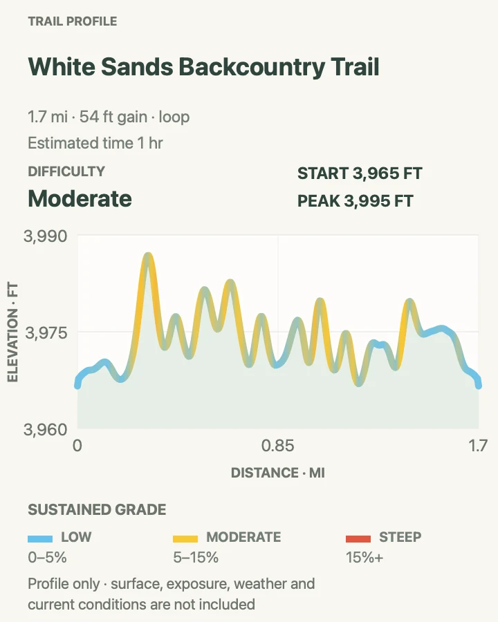
| Backcountry Camping Loop Trail | About 2-mile loop | 1 hr | Moderate | A compact heart-of-the-dunes route with repeated 40- to 50-foot climbs |
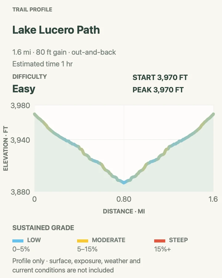
| Lake Lucero Ranger Tour | 1.5-mile guided walk | 1 hr | Easy | Seeing the dry lake bed and selenite crystals that feed the gypsum dunes |
Dune Life Nature Trail
- Distance
- 1-mile loop
- Elevation gain
- 90 feet
- Time
- 1 hr
- Difficulty
- Easy
- Route type
- loop
- Parking
- Use the signed lot 2.5 miles from the visitor center on Dunes Drive; vault toilets are at the trailhead.
- Best time
- At opening, when tracks from nocturnal animals are easier to spot and the sand is cool.
- Pets
- Leashed pets are allowed; keep them out of vegetated crust and carry water.
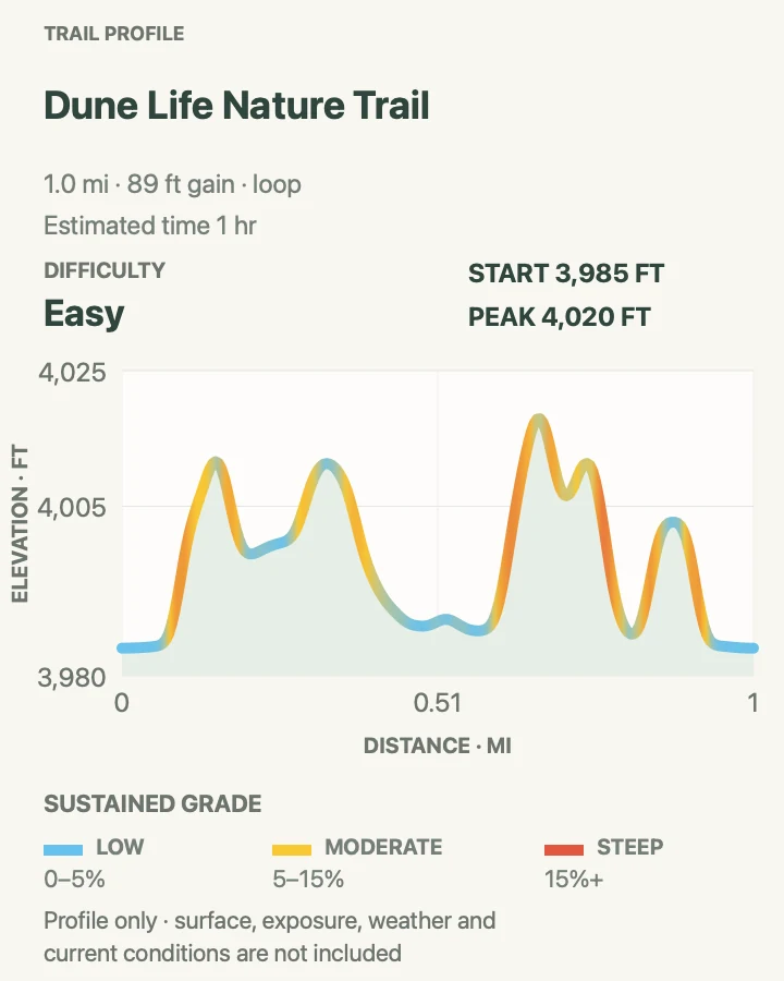
Dune Life sits on an ecotone, the meeting place between Chihuahuan Desert scrub and the gypsum dunes. Fourteen signs led by Katie the Kit Fox introduce the animals that use this edge. You may not see a kit fox or badger in daylight, but tracks often remain from the night before.
The blue club posts make a one-mile loop, yet two loose, steep dune climbs earn the park's moderate rating. The first 300 yards cross the flatter desert plain before the route climbs onto sand. This is an observation trail, not a sledding hill; vegetation around the edge is part of the story.
What helps on this route
- Scan the sand beside the route before other footprints cover overnight tracks.
- Do not continue past a blue club post unless the next one is visible.
Terrain and access: Desert plain, soft gypsum sand, two steep dune climbs, limited shade, blue club posts, interpretive signs, and sensitive vegetation near the route.

Alkali Flat Trail
- Distance
- 5 miles out and back
- Elevation gain
- 100 feet
- Time
- 2 hr 17 min
- Difficulty
- Moderate
- Route type
- out-and-back
- Parking
- Use the Alkali Flat lot about 7 miles from the visitor center; vault toilets are near the trailhead.
- Best time
- The coolest hours after the park opens, with light wind and several hours before sunset.
- Pets
- Leashed pets are allowed, but the full route is a strenuous heat and water commitment for a dog.
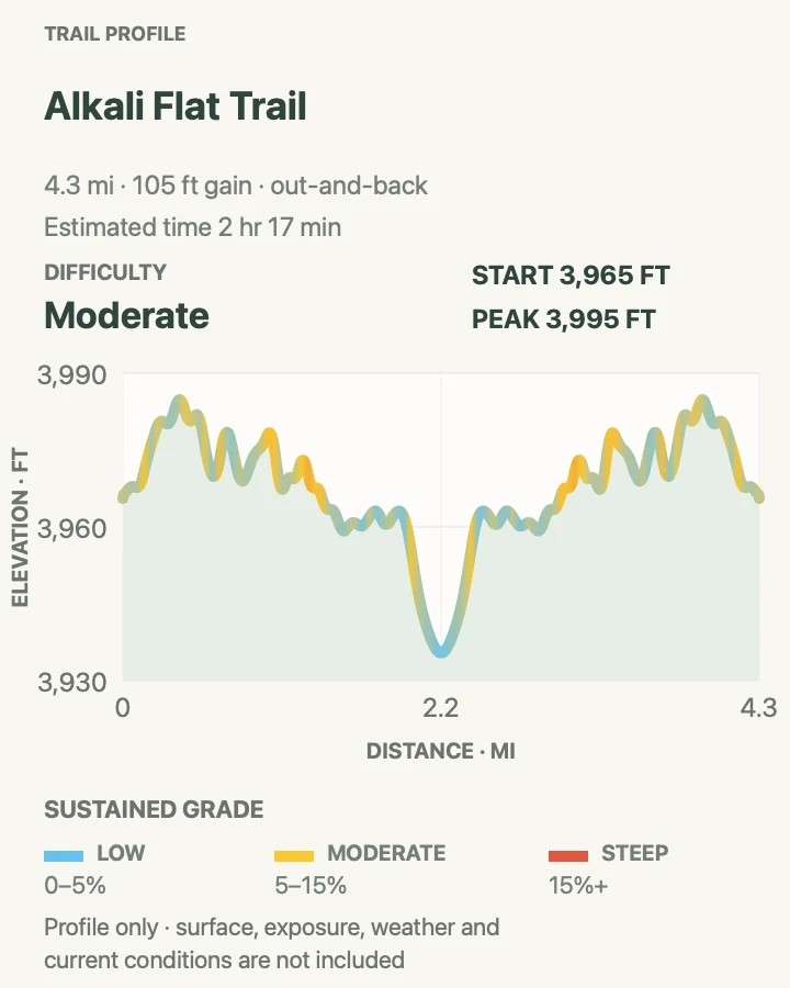
The name is a trap: reaching the edge of Alkali Flat means climbing dunes for most of the way. NPS rates the route strenuous and describes repeated rises around 60 feet high. Red diamond posts lead 2.5 miles away from the trailhead, then the same corridor returns to the car.
The pale basin at the turnaround is the remnant of Lake Otero, which filled much of the Tularosa Basin during the last ice age. That geologic scale can wait if the wind is building. A missing red diamond, rising temperature, or shrinking water supply is enough reason to reverse early.
What helps on this route
- Budget three to four hours; soft sand makes road pace irrelevant.
- Turn around before halfway if the return will cross the hottest part of the day.
Terrain and access: Continuous loose gypsum, repeated dune climbs near 60 feet, no shade or water, red diamond posts, blowing sand, exposed sun, and a remote dry-lake edge.

Playa Trail
- Distance
- 0.5 mile out and back
- Elevation gain
- 0 feet
- Time
- 7 min
- Difficulty
- Easy
- Route type
- out-and-back
- Parking
- Use the signed roadside lot 2.5 miles from the visitor center; no restroom is available at this trailhead.
- Best time
- Any cool part of the day, especially after weather has changed the playa surface.
- Pets
- Leashed pets are allowed; keep them on the marked path and away from biological soil crust.
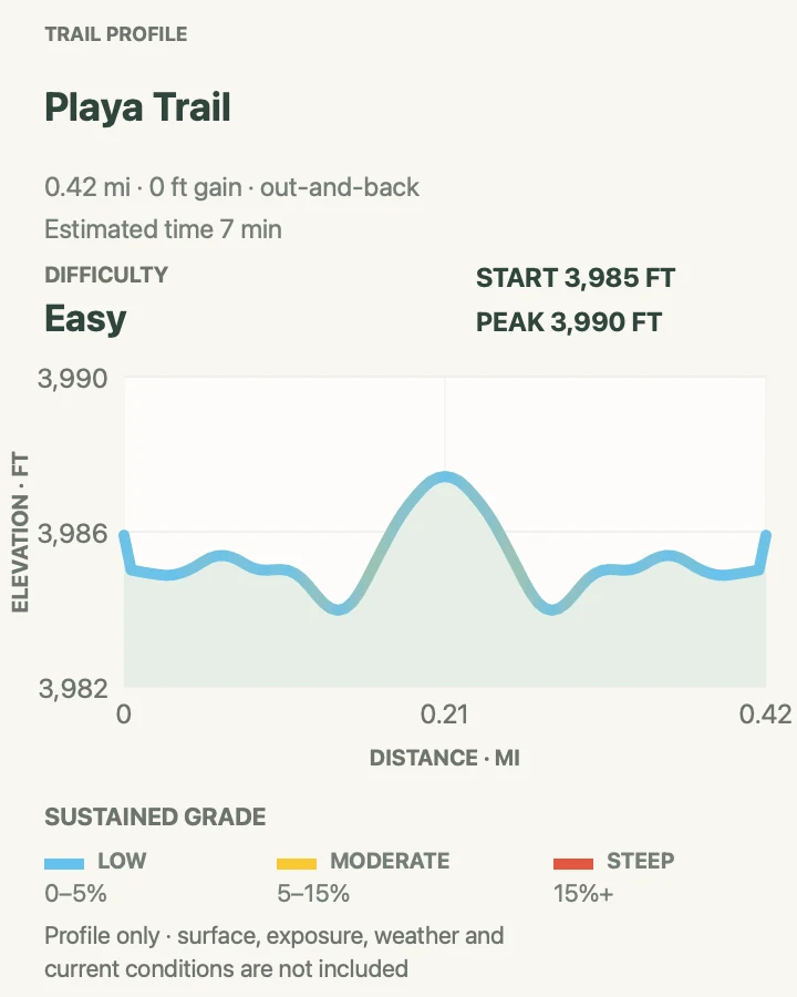
Green heart posts lead to a small playa with outdoor exhibits along the way. Depending on recent weather, the basin may be brown, white, wet, or growing crystals. The change is the point: this shallow depression alternates between habitat, hard surface, and temporary water.
The return is flat and short, but leaving the path can crush biological soil crust that takes far longer to recover than a footprint suggests. The final exhibits look back roughly 10,000 years to the large animals that crossed the basin when conditions were very different.
What helps on this route
- Expect a 30-minute stop if you read the exhibits instead of treating it as a mileage target.
- Look at the playa you actually find; water is only one of its normal states.
Terrain and access: Level hard ground, a short marked approach, green heart posts, exposed sun, outdoor exhibits, sensitive biological soil crust, and a playa that may be dry or wet.

Backcountry Camping Loop Trail
- Distance
- About 2-mile loop
- Elevation gain
- 55 feet
- Time
- 1 hr
- Difficulty
- Moderate
- Route type
- loop
- Parking
- Use the signed lot about 6.5 miles from the visitor center on Dunes Drive; vault toilets are at the trailhead.
- Best time
- Early morning or a cool late-day window with enough time to finish before closing.
- Pets
- Leashed pets are allowed; soft sand and hot conditions demand conservative timing.
Orange spade posts trace this loop through varied dunes and scattered soaptree yuccas. The two-mile distance sounds modest, but the route repeatedly climbs loose slopes around 40 to 50 feet high. Allow at least 90 minutes, and more when the sand is hot or soft.
The name needs explanation in 2026. Backcountry camping is closed while the park assesses conditions, with no reopening date, but NPS still describes the marked loop as a front-country day hike. Walk the loop; do not occupy a campsite or plan an overnight stay.
What helps on this route
- Use the orange spades, not campsite markers, to hold the loop.
- Do not time a sunset walk so tightly that one missed post risks the gate closing.
Terrain and access: Loose gypsum, repeated 40- to 50-foot dunes, orange spade posts, almost no shade, sparse plants, backcountry site markers, and open views toward the San Andres Mountains.

Lake Lucero Ranger Tour
- Distance
- 1.5-mile guided walk
- Elevation gain
- 80 feet
- Time
- 1 hr
- Difficulty
- Easy
- Route type
- out-and-back
- Parking
- Meet at the Small Missile Range Gate on U.S. 70 between mile markers 174 and 175; the group caravans 17.5 miles each way to the trailhead.
- Best time
- One of the scheduled monthly mornings from November through March, with a ticket bought in advance.
- Pets
- Leashed, non-disruptive pets are allowed, but the remote three-hour program and rough ground deserve careful thought.
Lake Lucero is not a trailhead you can drive to on your own. NPS offers a ticketed ranger program, generally once a month from November through March, and the entire group enters and leaves White Sands Missile Range property in a caravan. Late arrivals cannot catch up.
The walk descends a rough arroyo to a dry lake bed where selenite crystals form. It is about 1.5 miles on loose, uneven ground, with the return gently uphill. The full program lasts three hours, emergency response may take up to an hour, and photography is restricted until the ranger says the group has reached park land.
What helps on this route
- Bring closed-toe shoes and at least two liters of water for the walking portion.
- Carry enough fuel and a usable spare tire for the 35-mile caravan drive.
Terrain and access: Rough unmaintained desert path, loose arroyo, gradual descent to a dry lake bed, gentle uphill return, exposed sun, crystals, remote access, and no trailhead services.

Official planning sources
Trail access and safety details were checked against these National Park Service pages. The maps and profiles use the reviewed route geometry stored with this guide.
- NPS: White Sands current conditions
- NPS: Safety corridor and Interdune Boardwalk closure
- NPS: White Sands hiking overview
- NPS: Dune Life Nature Trail
- NPS: Alkali Flat Trail
- NPS: Playa Trail
- NPS: Backcountry Camping Loop Trail
- NPS: Backcountry camping closure
- NPS: Lake Lucero Tour and 2026–2027 dates
- NPS: White Sands safety
- NPS: White Sands pet rules
- NPS: White Sands operating hours
Map data © OpenStreetMap contributors. Trail geometry and planning details include National Park Service public information.