6 Best Hikes in Congaree National Park
Six Congaree hikes from the accessible Boardwalk Loop to Cedar Creek, the Congaree River, and a separate historic ferry road.
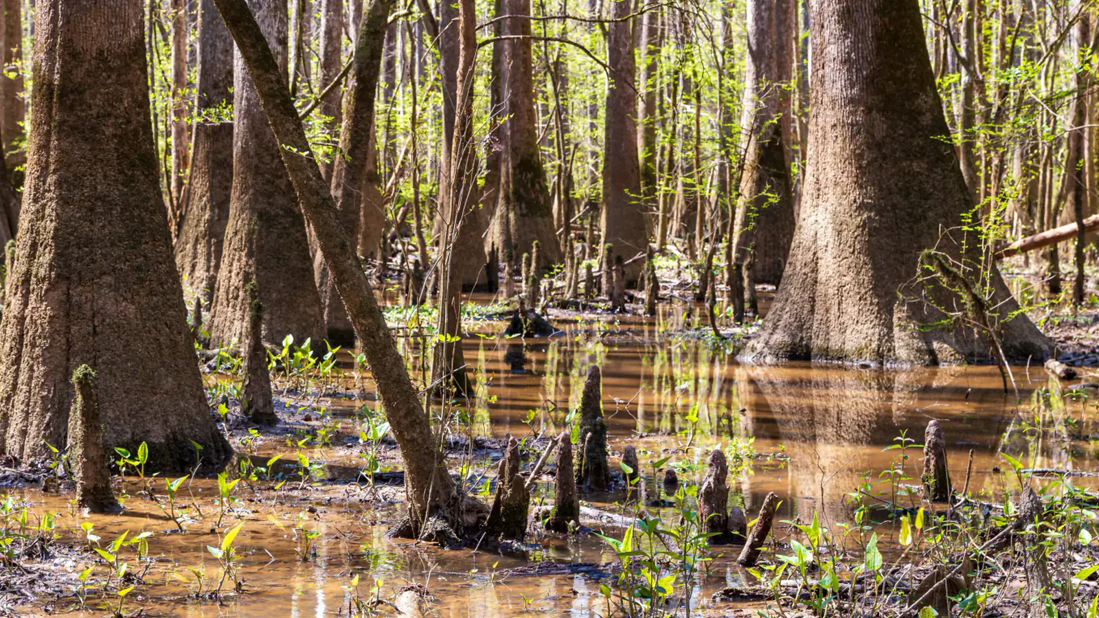
Congaree is almost flat, yet its longer hikes are not automatic easy miles. Water moves through old river channels, fallen trees blur the path, and brown blazes can disappear into a dense wall of trunks. The decision before a hike is less about climbing and more about flooding, navigation, heat, and how far you want to commit into the floodplain.
These six routes are grouped by the outing they offer rather than by a crowd-sourced popularity list. The Boardwalk is the accessible introduction. Bluff and Sims stay close to the visitor-center trail network. Weston Lake reaches the cypress-tupelo sloughs, while River Trail and Bates Ferry earn their place by arriving at the Congaree River from very different directions.
NPS listed all six routes as open when this guide was checked on August 29, 2026. That status is only a starting point. The park floods about ten times in an average year, and even the lower section of the boardwalk can go underwater. Read the alert page and the river gauges on the morning of the walk.
What changes a hiking day here
Check water before mileage
Nearly four-fifths of the park lies in the river floodplain. NPS notes approximate flood stages of eight feet at the Cedar Creek gauge and 15 feet on the Congaree River at the park's west boundary. A trail page can still say open while a fresh rise makes a low section impassable, so use the live alert and gauges together.
Carry the map offline
Most routes use brown numbered blazes, but backcountry intersections, flood debris, and old road beds can make the next turn less obvious than the mileage suggests. Download the NPS map, take a paper trail guide from Harry Hampton Visitor Center, and do not depend on a phone signal.
Plan for insects and wet heat
Mosquitoes are expected from mid-spring through mid-fall. Repellent, water, and breathable clothing matter even on the boardwalk, and ticks warrant a full check after brushier routes. Thunderstorms and humidity can turn an ordinary pace into a slow one.
Dogs can come, with limits
Pets are allowed on every trail in this guide, including the boardwalk, but must remain on a leash no longer than six feet. Bring their water, pick up waste, check for ticks, and never leave an animal unattended. The confined elevated boardwalk may be a poor fit for a dog uneasy around people or other pets.
| Trail | Distance | Time | Difficulty | Best for |
|---|---|---|---|---|
| Boardwalk Loop | About 2.6-mile loop | 41 min | Easy | A first look at old-growth bottomland forest on an accessible route |
| Bluff Trail | About 1.8-mile loop | 1 hr | Easy | A short woodland loop on the park's higher ground |
| Sims Trail | About 3.2 miles round trip | 1 hr | Easy | An easy-to-read old road with links into the wider trail network |
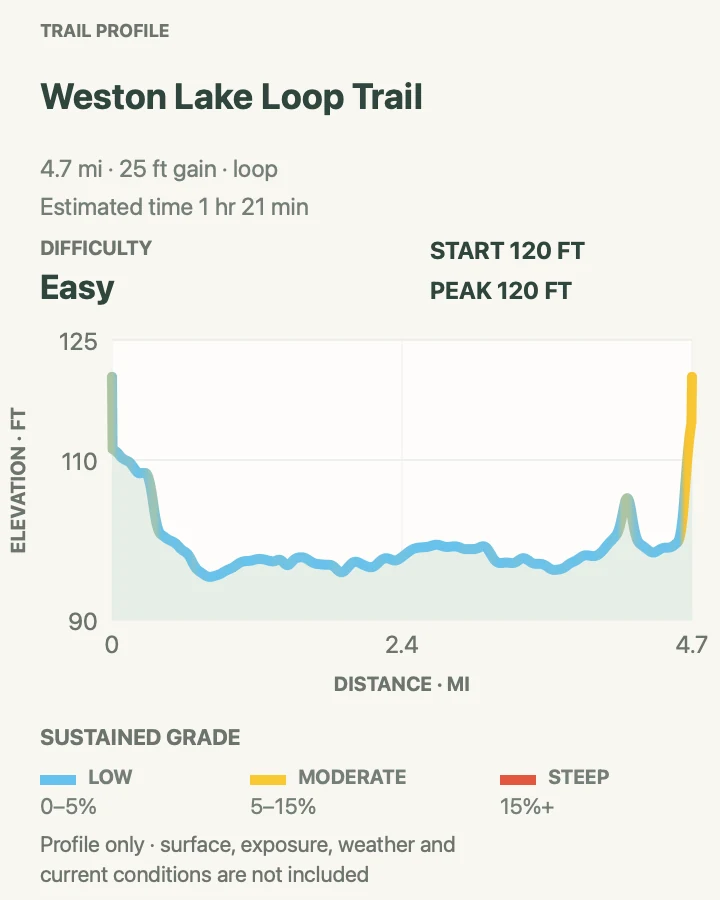
| Weston Lake Loop | About 4.5-mile loop | 1 hr 21 min | Easy | Cedar Creek, cypress knees, sloughs, and a half-day forest circuit |
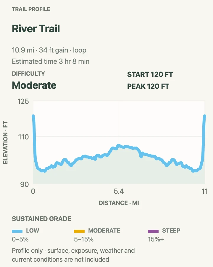
| River Trail | About 11.1-mile loop | 3 hr 8 min | Moderate | A full-day walk to the Congaree River and its low-water sandbar |
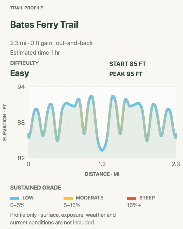
| Bates Ferry Trail | About 2.2 miles out and back | 1 hr | Easy | A short historic road walk to the park's eastern riverbank |
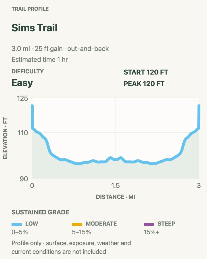
Boardwalk Loop
- Distance
- About 2.6-mile loop
- Elevation gain
- 35 feet
- Time
- 41 min
- Difficulty
- Easy
- Route type
- loop
- Parking
- Start at Harry Hampton Visitor Center, where the main park road ends.
- Best time
- Morning for cooler air, more active birds, and a quieter lower boardwalk.
- Pets
- Leashed pets are allowed; use extra care on the confined elevated section.
The boardwalk begins on the higher bluff, then drops into a forest of bald cypress, tupelo, loblolly pine, oak, maple, and holly. Benches and the self-guided brochure make this the rare short route that rewards a deliberately slow lap. It is wheelchair and stroller accessible, though conditions can still affect the lower portion.
The upper and lower sections feel different. The elevated stretch gives a clean look into the forest without muddy footing; the lower stretch sits close to roots, knees, and standing water. Flooding can cover that lower section, so an open visitor center does not guarantee a dry full loop.
What helps on this route
- Pick up the self-guided brochure before leaving the visitor center.
- If floodwater covers the lower boardwalk, turn around rather than stepping into water of uncertain depth.
Terrain and access: Wooden boardwalk, gentle ramps, benches, a mix of elevated and low sections, wheelchair and stroller access, shade, and possible floodwater on the lower loop.

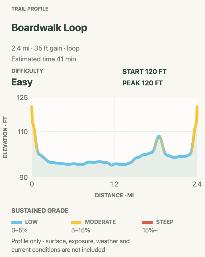
Bluff Trail
- Distance
- About 1.8-mile loop
- Elevation gain
- 15 feet
- Time
- 1 hr
- Difficulty
- Easy
- Route type
- loop
- Parking
- Use Harry Hampton Visitor Center and join the signed loop north of the building.
- Best time
- After recent rain, when lower floodplain routes may be wet.
- Pets
- Leashed pets are allowed; carry water and remove waste.
Bluff Trail stays in younger loblolly and longleaf pine forest north of the visitor center. It briefly shares the elevated boardwalk, then makes its own loop through ground shaped by prescribed fire. The route is subtle rather than dramatic, which is exactly why it works on a wet visit.
This is one of the few Congaree trails NPS does not list among those subject to periodic flooding. That does not mean it will always be dry, but it offers a useful fallback when Cedar Creek or the low boardwalk has risen. The junctions near the visitor center also make it easy to shorten the outing.
What helps on this route
- Read the signs explaining prescribed fire instead of assuming every blackened trunk marks damage.
- Combine it with only the open portion of the boardwalk when high water closes the lower loop.
Terrain and access: Mostly level dirt path through young pine forest, a short shared boardwalk section, roots, leaf litter, and generally less flood exposure than the lowland trails.

Sims Trail
- Distance
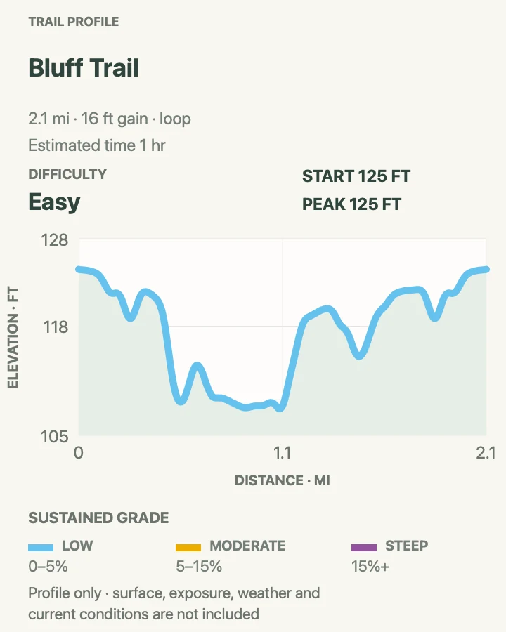
- About 3.2 miles round trip
- Elevation gain
- 25 feet
- Time
- 1 hr
- Difficulty
- Easy
- Route type
- out-and-back
- Parking
- Begin at Harry Hampton Visitor Center and use the boardwalk or Bluff Trail to reach the signed Sims junction.
- Best time
- A dry morning when the Cedar Creek end is passable.
- Pets
- Leashed pets are allowed; check paws and coats for ticks afterward.
Sims follows an old gravel road from Bluff Trail south to Cedar Creek, crossing the boardwalk twice. Its straighter shape and firmer old road bed feel different from the winding slough trails. At the Weston Lake junction, a clearing marks the site of a former hunt club associated with Harry Hampton.
The geometry is simple, but the southern end still enters flood-prone ground. Use this as a stand-alone out-and-back or as a connector only after checking which adjacent trail segments are passable. Wise Lake adds a quiet side trip when its spur is dry and clearly marked.
What helps on this route
- Count both boardwalk crossings so the return junction does not sneak past you.
- Do not build a longer loop on the fly after recent flooding; confirm every connector first.
Terrain and access: Old gravel road, very small elevation changes, shaded forest, several signed crossings, possible mud near Cedar Creek, and occasional flood debris.

Weston Lake Loop
- Distance
- About 4.5-mile loop
- Elevation gain
- 25 feet
- Time
- 1 hr 21 min
- Difficulty
- Easy
- Route type
- loop
- Parking
- Start at Harry Hampton Visitor Center and reach the loop through the boardwalk trail network.
- Best time
- Early morning after several dry days, when wildlife is active and the slough crossings are easier to read.
- Pets
- Leashed pets are allowed; bring enough water for the full loop.
Weston Lake is the best step beyond the boardwalk for hikers who want a longer sample of Congaree without committing to the river. One side approaches Cedar Creek, where otters and wading birds may appear. The eastern side follows a cypress-tupelo slough lined with knees and low, wet ground.
NPS rates the route moderate even though the profile barely rises. Distance, flood exposure, and navigation explain that rating. Brown blazes can blend into the forest, and an easy-looking low spot may hold deeper water than expected. Treat an obscured trail as a reason to retreat, not as an invitation to bushwhack.
What helps on this route
- Pause quietly near Cedar Creek; movement and loud voices usually end a wildlife sighting.
- Save the visitor-center trail map offline before entering the loop.
Terrain and access: Flat forest path, cypress-tupelo slough, roots, mud, cypress knees, creek edges, brown blazes, possible standing water, and a few boardwalk connections.

River Trail
- Distance
- About 11.1-mile loop
- Elevation gain
- 35 feet
- Time
- 3 hr 8 min
- Difficulty
- Moderate
- Route type
- loop
- Parking
- Use Harry Hampton Visitor Center and enter through the signed backcountry trail network.
- Best time
- A cool, dry day with low river gauges and enough daylight for a slow return.
- Pets
- Leashed pets are allowed, but heat, water needs, ticks, and the distance make this a serious pet outing.
The long river route reaches the waterway that drives the park's flood cycle. When the river is low, a broad sandbar may be visible. The forest near the river was logged before the park was established, so dense regrowth makes the corridor feel tighter than the old-growth sections near the boardwalk.
A flat profile can give the wrong impression here. NPS rates the outing difficult because of its length, flood risk, and route-finding demands. Turn around if water blocks the blazes, and keep a firm time cutoff; unreliable cell reception is especially consequential this far from the visitor center.
What helps on this route
- Leave your route and return time with someone who is not on the hike.
- Do not walk onto the sandbar when water is rising or the bank is unstable.
Terrain and access: Long flat backcountry loop, dense regrowth, roots, mud, fallen timber, intermittent standing water, riverbank, possible sandbar, sparse wayfinding, heat, and insects.

Bates Ferry Trail
- Distance
- About 2.2 miles out and back
- Elevation gain
- 0 feet
- Time
- 1 hr
- Difficulty
- Easy
- Route type
- out-and-back
- Parking
- Use the signed Bates Ferry trailhead on U.S. Route 601, separate from Harry Hampton Visitor Center.
- Best time
- A dry morning with low river levels and good visibility on Route 601.
- Pets
- Leashed pets are allowed; keep them close at the steep riverbank.
Bates Ferry follows a 1920s ferry road to the Congaree River from the park's east side. Ferries crossed nearby in the colonial era, so the straight road trace carries a human story that the visitor-center loops do not. It is also a practical short river hike when an 11-mile day is out of the question.
The final bank is steep and can be slippery. Stop on firm ground, particularly after rain or a recent rise. Old side trails leave the ferry road, but NPS says they are neither cleared nor marked; the correct route is the obvious out-and-back, not a speculative loop.
What helps on this route
- Set the Route 601 trailhead in navigation before leaving reliable service.
- Stay on the ferry road and view the river from a stable spot above the bank.
Terrain and access: Nearly level historic road, compacted soil and leaf litter, dense forest, occasional wet ground, a steep slippery riverbank, and no maintained side-trail options.

Official planning sources
Trail access and safety details were checked against these National Park Service pages. The maps and profiles use the reviewed route geometry stored with this guide.
Map data © OpenStreetMap contributors. Trail geometry and planning details include National Park Service public information.