2 Best Hikes and Walks in Dry Tortugas National Park
Two honest Dry Tortugas walks: a Fort Jefferson and moat circuit on Garden Key, plus the seasonal Bush Key shoreline route.
Dry Tortugas is mostly water. The land visitors can walk is measured in acres, not mountain ranges, and the boat or seaplane schedule shapes the day more than elevation does. A list of ten hikes here would be nonsense.
There are two worthwhile foot routes. One circles and enters Fort Jefferson on Garden Key. The other follows the Bush Key shore during the short season when nesting birds no longer need the island closed. Both are nearly flat; exposure, loose coral, slippery brick, heat, and strict wildlife boundaries supply the difficulty.
Bush Key is closed for nesting season on August 29, 2026, when this guide was checked. It is usually available from roughly mid-October to mid-January, but the sand connection shifts and the superintendent sets the actual dates. Fort Jefferson and Garden Key remain the walking plan for a summer visit.
What changes a hiking day here
Build the walk around transportation
Ferry and seaplane visitors land on Garden Key after crossing about 68 miles of open sea from the Key West area. Their return departure is fixed. Private boaters have more time, but must still check in and follow dock and anchorage rules. Know the boarding call before starting a second lap around the fort.
Bring every basic item from the mainland
The island has no snack bar or public store for forgotten medicine, sun protection, or walking shoes. Pack drinking water, food, a hat, sunscreen, and motion-sickness medicine before boarding. The visitor center sells books and souvenirs, not a replacement day kit.
Read the offshore forecast
Wind, seas, storms, tide, and current affect the trip even when the walk itself is flat. Private boaters need the offshore forecast and a self-rescue plan; day visitors should still expect the return crossing to feel different from the morning ride.
Pet access is unusually narrow
Pets are allowed on Garden Key exterior areas but not inside Fort Jefferson or on any other island. They must remain leashed and attended. The commercial ferry and seaplane do not carry pets, so most visitors cannot bring one. Sealed black bait boxes contain rodenticide and must never be disturbed.
| Trail | Distance | Time | Difficulty | Best for |
|---|---|---|---|---|
| Fort Jefferson and Moat Walk | Roughly 0.7-mile circuit | 1 hr | Easy | Fort history, moat water, coastal views, and the park's only all-season land circuit |
| Bush Key Shoreline Walk | About 1 mile out and back when open | 1 hr | Easy | An undeveloped subtropical shore and bird habitat outside the fort |
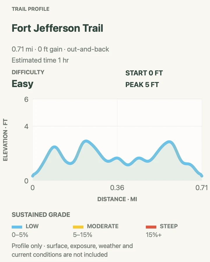
Fort Jefferson and Moat Walk
- Distance
- Roughly 0.7-mile circuit
- Elevation gain
- 0 feet
- Time
- 1 hr
- Difficulty
- Easy
- Route type
- out-and-back
- Parking
- There is no road access. Walk from the ferry, seaplane, or private-boat landing on Garden Key.
- Best time
- Soon after arrival, before the fort's brick and open parade ground heat up.
- Pets
- Pets may use leashed exterior Garden Key areas but cannot enter Fort Jefferson.
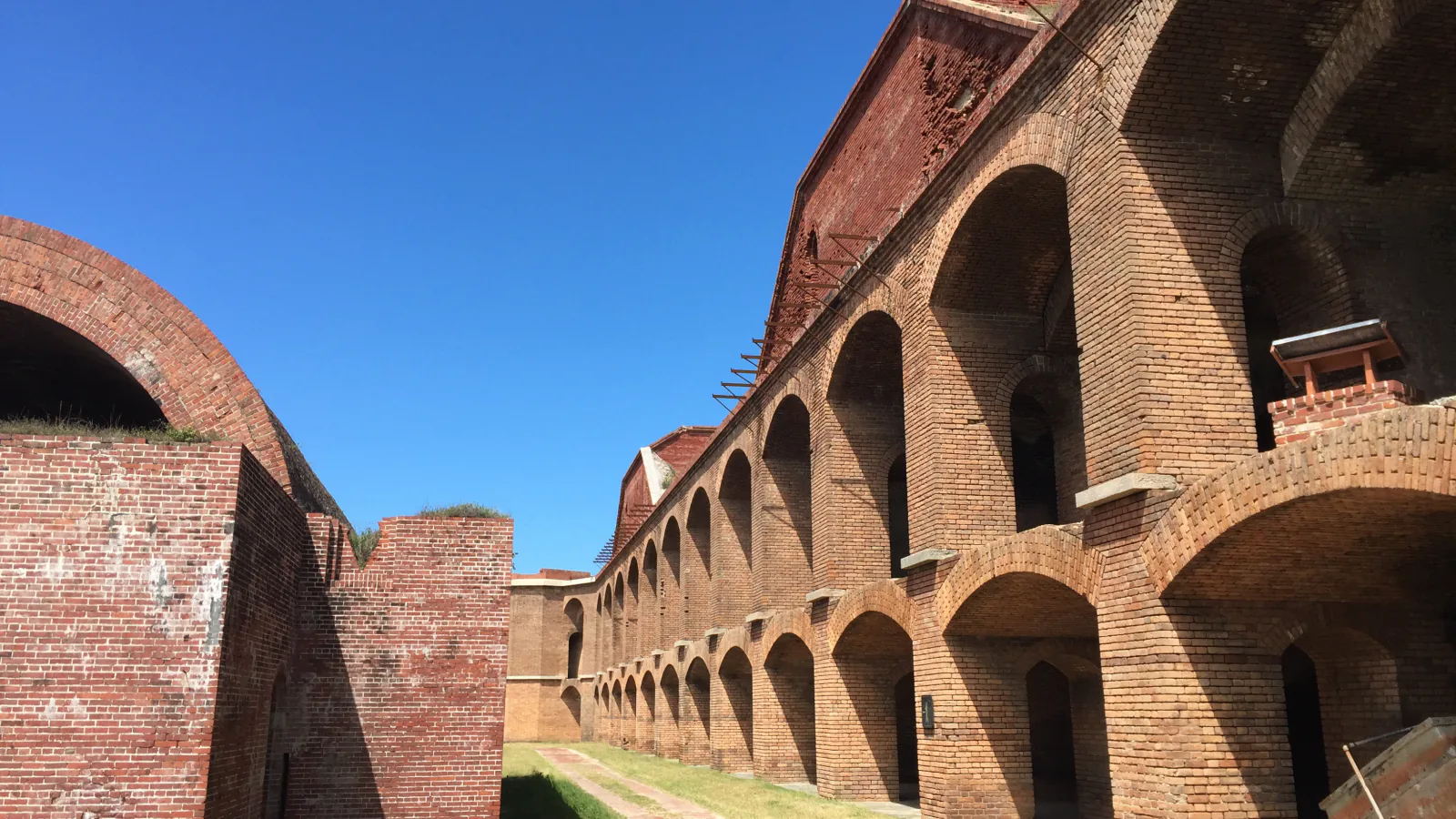
Begin at the visitor center inside Fort Jefferson, then make a self-guided circuit through the first-tier arches, parade ground, and open brick passages. Construction began in 1846, and the massive walls were built to defend the shipping route through the Gulf of Mexico. The empty gun rooms and rust-stained masonry make more sense when seen at walking speed.
Continue outside along the moat and seawall for the water-facing half of the route. The brick, grass, and exterior path are almost level, but surfaces can be uneven or slick. Upper fort levels are not wheelchair accessible; the first tier and exterior trail provide the accessible portion. Stay behind every barricade near damaged masonry and the closed South Coaling Dock ruins.
What helps on this route
- Visit the interior before a ferry crowd compresses the narrow stairs and passages.
- Keep swimming and snorkeling outside the moat; entering the moat water is prohibited.
Terrain and access: Brick walkways, grass, fort passages, stairs to upper tiers, nearly level exterior path, exposed sun, uneven historic surfaces, low seawall, and salt spray.

Bush Key Shoreline Walk
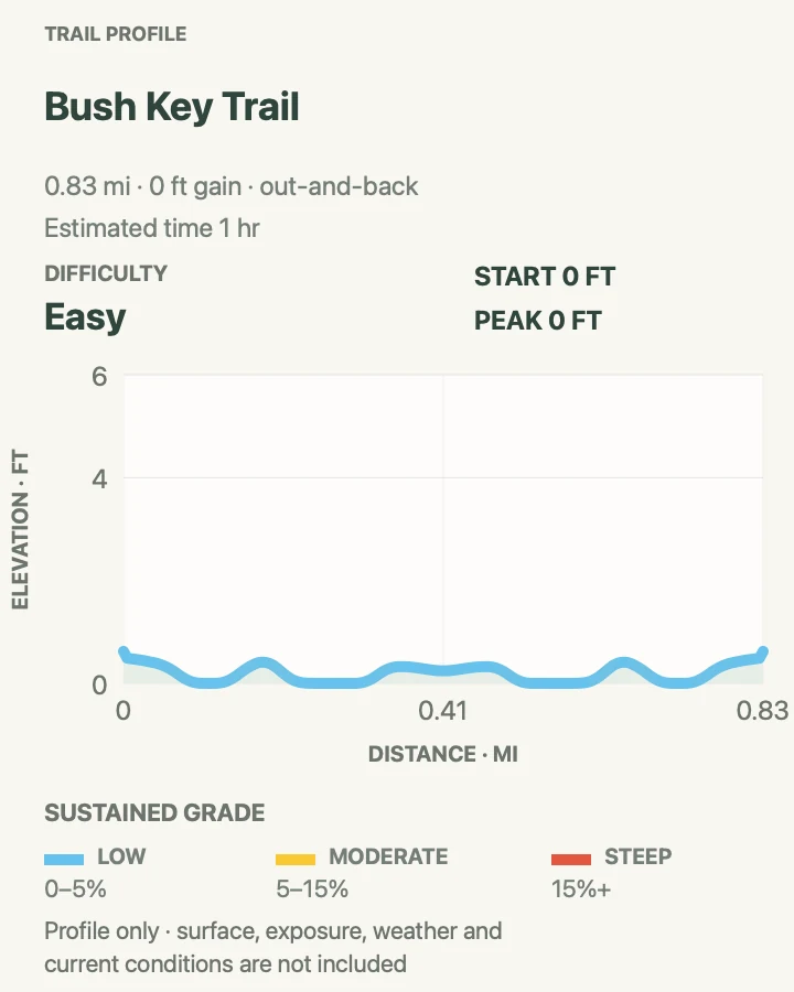
- Distance
- About 1 mile out and back when open
- Elevation gain
- 0 feet
- Time
- 1 hr
- Difficulty
- Easy
- Route type
- out-and-back
- Parking
- Start from Garden Key only after a ranger confirms Bush Key is open and the shore connection is usable.
- Best time
- A calm daylight visit from roughly mid-October to mid-January, after the nesting closure has ended.
- Pets
- Pets are prohibited on Bush Key.
Bush Key closes through the tern nesting season, generally from about mid-February to mid-October. Up to tens of thousands of sooty terns and thousands of brown noddies use the 16-acre island. During that closure, people and vessels must keep their distance; the route in the map is a future-season plan, not permission to enter today.
When the island opens, the one-mile shoreline walk stays below the vegetation line and above the water. The surface changes from sand to coral rubble, so shoes beat bare feet. The land bridge to Garden Key moves with storms and currents. Ask a ranger where access begins and turn back at any closure marker rather than wading around it.
What helps on this route
- Check the actual opening date on arrival; a calendar estimate does not override signs or a ranger.
- Keep off recovering plants and leave coral, shells, and every natural object where found.
Terrain and access: Flat sand, coral rubble, narrow shoreline, no shade or water, changing land connection, sensitive vegetation, nesting closure, salt wind, and wet footing near the tide line.

Official planning sources
Trail access and safety details were checked against these National Park Service pages. The maps and profiles use the reviewed route geometry stored with this guide.
- NPS: Dry Tortugas current conditions
- NPS: Garden Key access, facilities, and current area closures
- NPS: Bush Key access and nesting season
- NPS: 2026 superintendent's compendium
- NPS: Dry Tortugas hours and seasonal island access
- NPS: Dry Tortugas safety
- NPS: Dry Tortugas accessibility
- NPS: Dry Tortugas pet rules
- NPS: Getting around the park
Map data © OpenStreetMap contributors. Trail geometry and planning details include National Park Service public information.