6 Best Hikes in Voyageurs National Park
Six worthwhile Voyageurs hikes with reviewed maps, elevation profiles, exact access notes, and current NPS planning links.
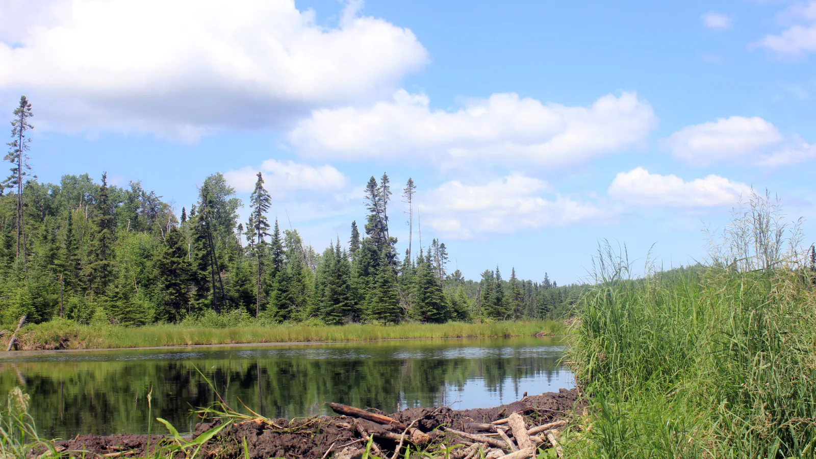
Voyageurs is a water park first. Most of its shoreline, campsites, and long backcountry routes are reached by boat, while the easiest road-access hiking is concentrated near Rainy Lake and Ash River. A trail list that ignores that divide can send a visitor to the right hike with no practical way to reach it.
These six routes cover every distinct four-star hike in the reviewed local source set. Five begin from roads near Rainy Lake or Ash River. Locator Trail is the exception: its trailhead is on the Kabetogama Peninsula and requires water access. Each terrain map and elevation profile uses the reviewed line for that route, so the figures may vary slightly from rounded NPS mileage.
Conditions were checked on August 29, 2026. NPS lifted the parkwide campfire ban on August 24 but notes that drought continues. The August Kabetogama boat-launch work has ended; more partial closures are expected in October, with dates still to be announced. Check the park alert and weather pages again before a drive or launch.
What changes a hiking day here
Separate road-access and water-access hikes
Oberholtzer begins at Rainy Lake Visitor Center. Blind Ash Bay, Kabetogama Lake Overlook, Beaver Pond Overlook, and Sullivan Bay use the Ash River entrance road. Locator Trail begins on the Kabetogama Peninsula and cannot be reached by driving to the name shown on the map. Arrange a safe boat approach and carry a navigational chart.
Ash River can support a full hiking day
Kabetogama Lake Overlook joins Blind Ash Bay, while Beaver Pond Overlook and Sullivan Bay start farther down Meadwood Road. Combining two short routes is more efficient than driving among visitor-center districts. The park entrance fee is free, though boat rentals and other services are not.
Wet ground and insects are normal trail conditions
Boreal lowlands hold water after rain and can remain muddy. Mosquitoes, biting flies, and ticks peak in warmer months. Bring repellent, inspect for ticks, and expect roots, rock, wet grass, and short boardwalks rather than dry western tread.
Do not use a phone as the only navigation tool
NPS warns that connections are unreliable and that its GPS data is not a substitute for waterway navigation. Download the trail map, carry a paper lake chart for boat access, and leave a route and return time with someone ashore.
Pets are prohibited on these six trails
Voyageurs allows pets in several developed and frontcountry places, but not on park hiking trails other than the paved Rainy Lake Recreation Trail. None of the six selected routes is that exception. Trained service animals may accompany visitors where the public can go.
| Trail | Distance | Time | Difficulty | Best for |
|---|---|---|---|---|
| Blind Ash Bay Trail | 2.9 miles by NPS; about 3.1 miles on the reviewed track | 1 hr 30 min | Moderate | The strongest road-access hike for forest, lake views, and varied terrain |
| Oberholtzer Trail | 1.6 miles by NPS; about 1.7 miles on the reviewed loop | 1 hr | Easy | An easy Rainy Lake introduction with a short accessible opening segment |
| Locator Trail | About 3.9 miles round trip on the reviewed track | 2 hr | Moderate | A true backcountry day linking the main lake system with Locator Lake |
| Sullivan Bay Trail | 1.5 miles by NPS; about 1.3 miles on the reviewed track | 1 hr | Easy | A wide, uncomplicated walk to a bay-side picnic point |
| Kabetogama Lake Overlook Trail | About 0.35 mile round trip | 1 hr | Easy | A fast lake view and an alternate entry to Blind Ash Bay |
| Beaver Pond Overlook Trail | About 0.3 mile round trip | 1 hr | Easy | A very short wetland observation walk |
Blind Ash Bay Trail
- Distance
- 2.9 miles by NPS; about 3.1 miles on the reviewed track
- Elevation gain
- 490 feet
- Time
- 1 hr 30 min
- Difficulty
- Moderate
- Route type
- Lollipop loop
- Parking
- Use the upper parking lot near Ash River Visitor Center; the route can also be joined from Kabetogama Lake Overlook.
- Best time
- A dry morning from late spring into fall, with insect protection in summer.
- Pets
- Pets are prohibited on this trail; trained service animals are allowed.
Blind Ash Bay leaves the Ash River development quickly. A narrow, rocky stem crosses rolling boreal forest before a loop reaches the peninsula between Kabetogama Lake and Blind Ash Bay. The west end opens a long lake view, while the interior alternates pine ridges with wetter low ground.
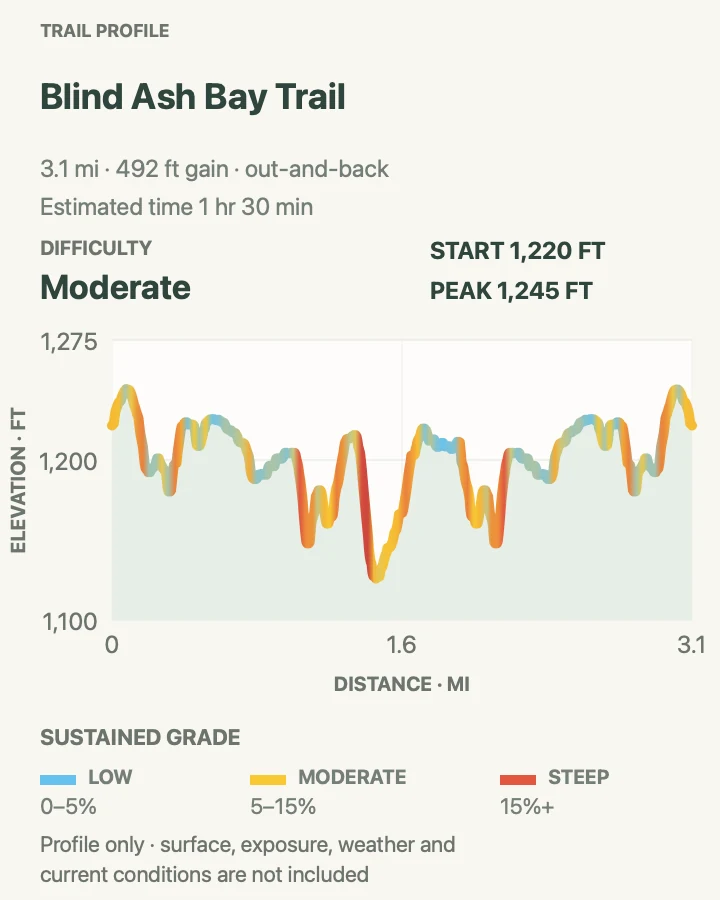
The reviewed profile counts nearly five hundred feet of accumulated climbing, much more than the small difference between its highest and lowest elevations suggests. Frequent short pitches create that total. Starting from Kabetogama Lake Overlook can bypass the steepest first section described by NPS.
What helps on this route
- Save the Ash River trail map before leaving reliable service.
- Take the loop deliberately at its junction so the return does not repeat the same shore branch.
Terrain and access: Narrow dirt trail, exposed roots and rock, repeated short climbs, wet lowlands, pine ridges, and lakeshore overlooks.

Oberholtzer Trail
- Distance
- 1.6 miles by NPS; about 1.7 miles on the reviewed loop
- Elevation gain
- 55 feet
- Time
- 1 hr
- Difficulty
- Easy
- Route type
- Loop
- Parking
- Park at Rainy Lake Visitor Center and find the trailhead on the south side of the building.
- Best time
- Morning in spring through fall for wetland birds; snowshoes are appropriate after winter snow.
- Pets
- Pets are prohibited beyond the separate pet-friendly Recreation Trail; trained service animals are allowed.
Oberholtzer moves between deciduous woods, conifers, glacial rock, and cattail wetland close to the Rainy Lake Visitor Center. Two viewpoints face marsh and lake habitat, making the route useful when a boat day is not possible or weather leaves only an hour for walking.
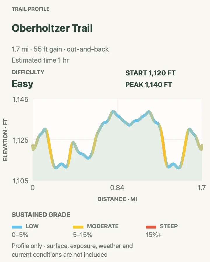
The first quarter mile is a four-foot-wide, flat crushed-gravel path described by NPS as accessible. Beyond it, the path becomes natural surface with roots and rock. The full reviewed line uses the connected loop and measures roughly 1.7 miles.
What helps on this route
- Ask at the visitor center about current wet sections before setting out.
- Stay quiet near the marsh overlooks; movement is often easier to spot before other visitors arrive.
Terrain and access: Crushed gravel at the accessible start, then dirt, roots, glacial rock, forest loops, wetland edges, and minor rolling grades.

Locator Trail
- Distance
- About 3.9 miles round trip on the reviewed track
- Elevation gain
- 540 feet
- Time
- 2 hr
- Difficulty
- Moderate
- Route type
- out-and-back
- Parking
- There is no road trailhead. Reach the Ash River shore trailhead on the Kabetogama Peninsula by boat and secure the craft without blocking the landing.
- Best time
- A stable, daylight boating window from late spring into fall, with enough margin for the return crossing.
- Pets
- Pets are prohibited on the trail and at Kabetogama Peninsula backcountry sites; trained service animals are allowed.
Locator Trail starts where a boat trip ends. From the Ash River shore on the Kabetogama Peninsula, the line crosses nearly two miles of forest and low ridges to Locator Lake. The hiking is moderate; organizing a safe launch, landing, and return makes the day more complex than its mileage.
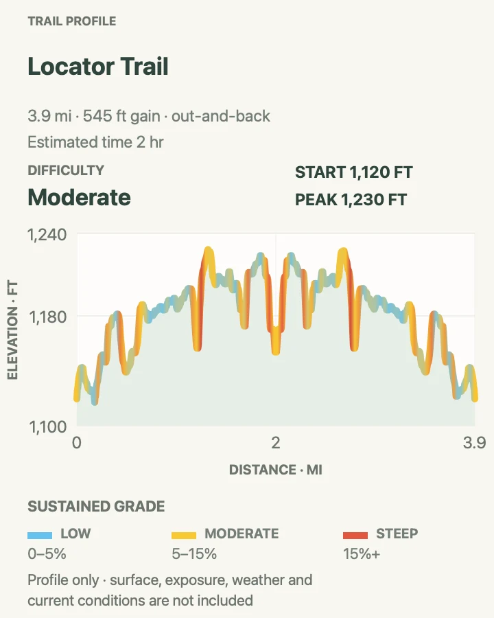
The track accumulates about 545 feet of climbing through small rises rather than one tall hill. Wet ground, sparse signs, and unreliable phone service increase the consequences of a wrong turn. Carry the trail map and a separate lake-navigation chart, and set a turnaround time that protects the boat return.
What helps on this route
- Do not attempt this as a drive-up trail; arrange water transport before leaving shore.
- Record the landing position and leave a float plan with a person who is not on the trip.
Terrain and access: Remote forest singletrack, low rocky ridges, wet depressions, repeated short grades, and a water-access trailhead.

Sullivan Bay Trail
- Distance
- 1.5 miles by NPS; about 1.3 miles on the reviewed track
- Elevation gain
- 120 feet
- Time
- 1 hr
- Difficulty
- Easy
- Route type
- out-and-back
- Parking
- Park on the grassy area in front of the gate on Meadwood Drive, 0.9 mile south of Ash River Visitor Center.
- Best time
- A dry afternoon or a cool-weather picnic stop; use snowshoes after winter snow.
- Pets
- Pets are prohibited on this trail; trained service animals are allowed.
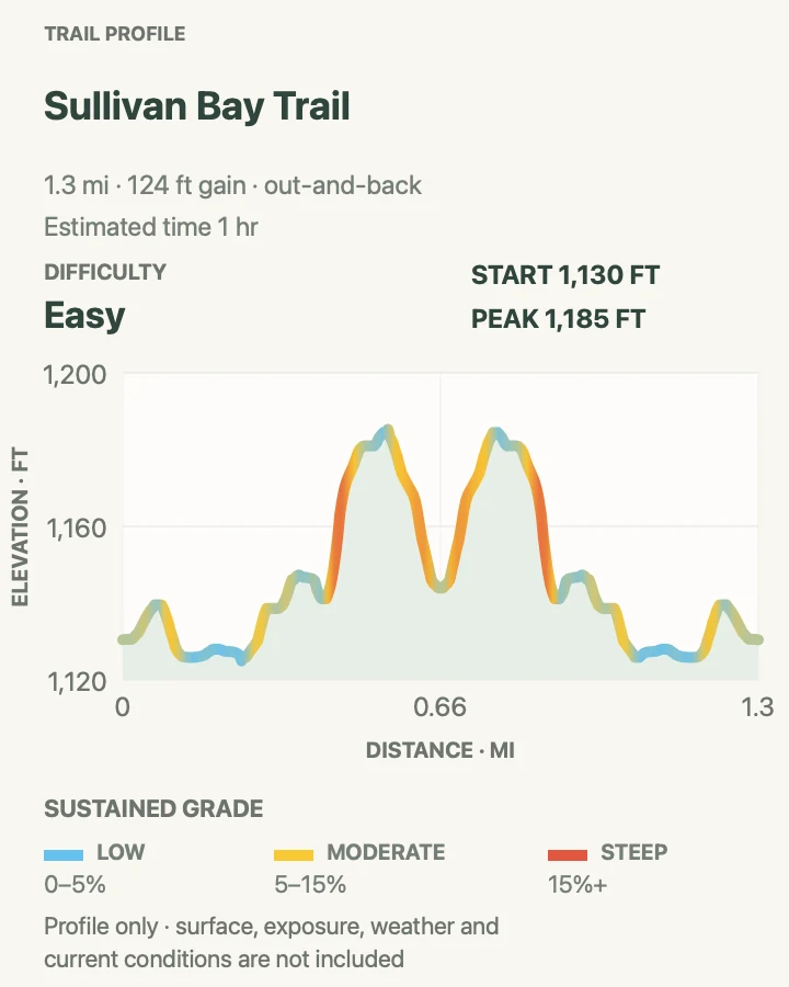
Sullivan Bay follows an old forest road toward the water. Conifer and deciduous woods give way to exposed ancient rock near a bay overlook with a picnic table and metal fire ring. It is a practical short hike after a longer Ash River route.
The trail is three to six feet wide, mostly grass and dirt, with a few brief climbs. The current fire notice allows fires in designated metal rings, but continuing drought means the rule can change. Check the same-day alert before treating the fire ring as available.
What helps on this route
- Parking is before the gate; do not drive onto the old road.
- Pack out food scraps and check the current fire restriction even when the metal ring is present.
Terrain and access: Wide grass-and-dirt forest road, short climbs, exposed bedrock, and a developed viewpoint beside Sullivan Bay.

Kabetogama Lake Overlook Trail
- Distance
- About 0.35 mile round trip
- Elevation gain
- 85 feet
- Time
- 1 hr
- Difficulty
- Easy
- Route type
- out-and-back
- Parking
- Use the upper parking area near Ash River Visitor Center at the Blind Ash Bay trailhead.
- Best time
- Clear morning or late-day light when a very short outing fits the schedule.
- Pets
- Pets are prohibited on this trail; trained service animals are allowed.
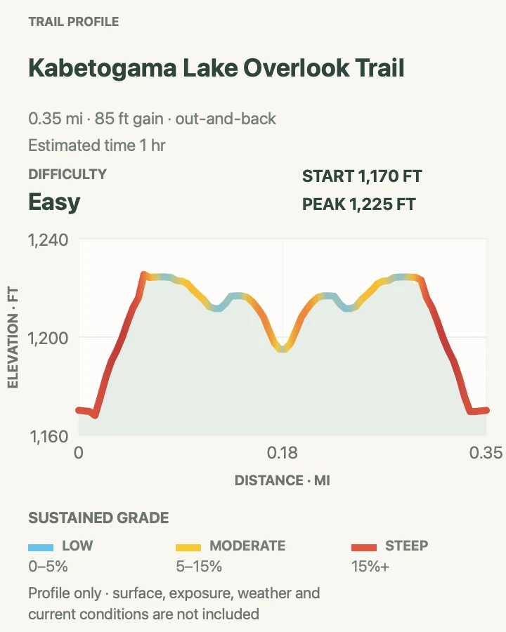
Kabetogama Lake Overlook is short but not flat. The path drops from the upper Ash River parking area, rolls across a shallow saddle, and reaches a view through the trees toward the lake. The reviewed line measures just over one-third mile round trip.
Its most useful role may be as the gentler connector into Blind Ash Bay, bypassing that trail's steep initial pitch. Hiked alone, it works when time, weather, or mobility makes a three-mile route unreasonable, though the surface remains natural and uneven.
What helps on this route
- Use the overlook connector only if its signed junction matches the saved Ash River map.
- Do not infer an accessible grade from the short distance; the profile includes steep pitches.
Terrain and access: Short natural-surface path with steep initial grades, roots, rock, a shallow saddle, and a wooded lake overlook.

Beaver Pond Overlook Trail
- Distance
- About 0.3 mile round trip
- Elevation gain
- 30 feet
- Time
- 1 hr
- Difficulty
- Easy
- Route type
- out-and-back
- Parking
- Use the signed Beaver Pond Overlook and Kab-Ash shared trailhead on Meadwood Road.
- Best time
- Dawn or dusk for wildlife activity, while keeping enough light for the return.
- Pets
- Pets are prohibited on this trail; trained service animals are allowed.
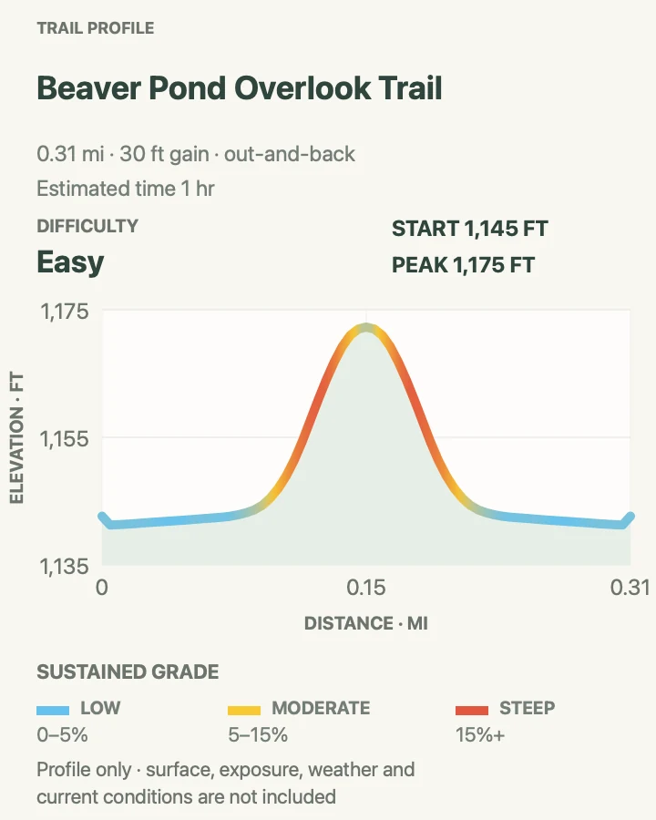
Beaver Pond Overlook is the smallest commitment in the guide: a roadside forest path to wetland habitat used by waterfowl and other wildlife. The track gains only about thirty feet, concentrated in one short rise before the overlook.
The value is observation rather than mileage. Stop, listen, and scan the pond edge instead of expecting a broad lake panorama. This trailhead also serves the much longer Kab-Ash system, so confirm that the short overlook path is the branch being followed.
What helps on this route
- Carry binoculars and keep voices low near the viewing area.
- Do not continue onto Kab-Ash by accident; it is a separate backcountry commitment.
Terrain and access: Short forest path, one low rise, damp wetland margin, and a small wildlife overlook near the road.

Official planning sources
Trail access and safety details were checked against these National Park Service pages. The maps and profiles use the reviewed route geometry stored with this guide.
- NPS: Current Voyageurs alerts, fire status, and boating notices
- NPS: Hiking and road-versus-boat access
- NPS: Trail locations by visitor-center district
- NPS: Lake navigation and emergency planning
- NPS: Current pet rules
- NPS: Oberholtzer Trail description and accessibility
- NPS: Blind Ash Bay Trail description
- NPS: Ash River and Blind Ash Bay birding terrain
- NPS: Sullivan Bay Trail description
- NPS: Permits, reservations, and current campsite access
Map data © OpenStreetMap contributors. Trail geometry and planning details include National Park Service public information.