6 Best Hikes in Mount Rainier National Park
Six Mount Rainier hikes from Myrtle Falls to Burroughs Mountain, with reviewed maps, elevation profiles, current fire closures, snow advice, and parking guidance.
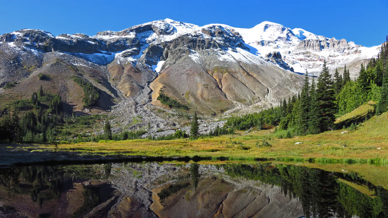
Mount Rainier rewards a short walk, but it does not make every short walk simple. Paradise begins around 5,400 feet, Sunrise around 6,400, and lingering snow can turn a signed summer trail into a navigation problem. Parking can be the day's first obstacle long before elevation becomes the second.
This six-hike list covers two very different sides of the mountain. Myrtle Falls, Skyline, and Bench and Snow Lakes use the Paradise and Stevens Canyon side. Naches Peak begins near Tipsoo Lake. Mount Fremont and Burroughs normally leave from Sunrise, where the drier high country feels almost alpine from the parking lot.
There is an urgent exception as this guide goes live on August 29, 2026. Sunrise Road, White River Road, and trails originating from them are closed because of the Grand Park 2 and Garda Falls fires. NPS lists Mount Fremont as closed and says there is no vehicle access for Burroughs. Treat those two sections as future planning only until the live alert disappears. Paradise's Skyline and Bench–Snow Lake trails were reported snow-free in the latest summer table.
What changes a hiking day here
No timed entry does not mean open parking
Mount Rainier has no timed-entry reservation anywhere in 2026. The park is managing parking directly and still expects full lots. NPS suggests arriving before 7 a.m. or after 4 p.m., trying a weekday, and carrying an alternate destination if the first lot is full.
Snow belongs in a summer plan
Paradise receives heavy snow, and high trails can keep it well into summer. Stay on the constructed line even when that means crossing a safe patch of snow; walking around it damages meadow plants. Avoid tree wells and snow moats, and turn back from an exposed slope if the snow gear or judgment is missing.
Keep three condition pages together
Check park alerts, road status, and the detailed trail table on the morning of the hike. A trail can be dry while its access road is closed, or an open road can lead to a snowy upper mile. Webcams help with cloud but do not replace a closure notice.
Leave pets off every selected route
Pets are prohibited on park trails, in wilderness, and off trail. A leash does not change that rule. The Pacific Crest Trail portion of Naches Peak is an exception only while it lies outside the park boundary; the complete loop still enters the park and is not a dog hike.
Give meadows less room than you think
Subalpine plants grow during a short season and recover slowly from trampling. Stay on trail, step onto durable rock for a pause, and do not widen the tread to pass a puddle or a photograph queue. Drones are prohibited throughout the park.
| Trail | Distance | Time | Difficulty | Best for |
|---|---|---|---|---|
| Myrtle Falls via Skyline Trail | 1 mile out and back | 27 min | Moderate | Families, limited time, waterfall views, and a first look at the Paradise meadow |
| Skyline Loop | About 5.5 miles by NPS; 5.7 miles on the reviewed loop | 4 hr 18 min | Hard | The complete Paradise climb to Glacier Vista, Panorama Point, and the high meadows |
| Bench and Snow Lakes Trail | 2.5 miles by NPS; about 2.3 miles on the reviewed out-and-back | 1 hr 9 min | Moderate | A shorter lake hike with repeated small climbs and Tatoosh Range views |
| Naches Peak Loop Trail | 3.4 miles by NPS; 3.5 miles on the reviewed loop | 1 hr 42 min | Moderate | A moderate scenic loop with a lighter climb and a long Mount Rainier backdrop |
| Mount Fremont Lookout via Sourdough Ridge | 5.6 miles by NPS; about 5.8 miles on the reviewed out-and-back | 2 hr 50 min | Moderate | An open-ridge hike to a 1930s fire lookout with broad Cascade views |
| Burroughs Mountain Loop | NPS lists 4.7 miles to First and 7 miles to Second Burroughs; the reviewed longer loop is about 9.6 miles | 5 hr 30 min | Hard | A hard tundra hike with unusually close views of Mount Rainier and Emmons Glacier |
Myrtle Falls via Skyline Trail
- Distance
- 1 mile out and back
- Elevation gain
- 190 feet
- Time
- 27 min
- Difficulty
- Moderate
- Route type
- out-and-back
- Parking
- Use the upper Paradise lot beside the Henry M. Jackson Memorial Visitor Center; overflow parking adds walking and may fill early.
- Best time
- A clear summer morning, or a short late-afternoon walk after the main parking crush.
- Pets
- Pets are prohibited on the trail.
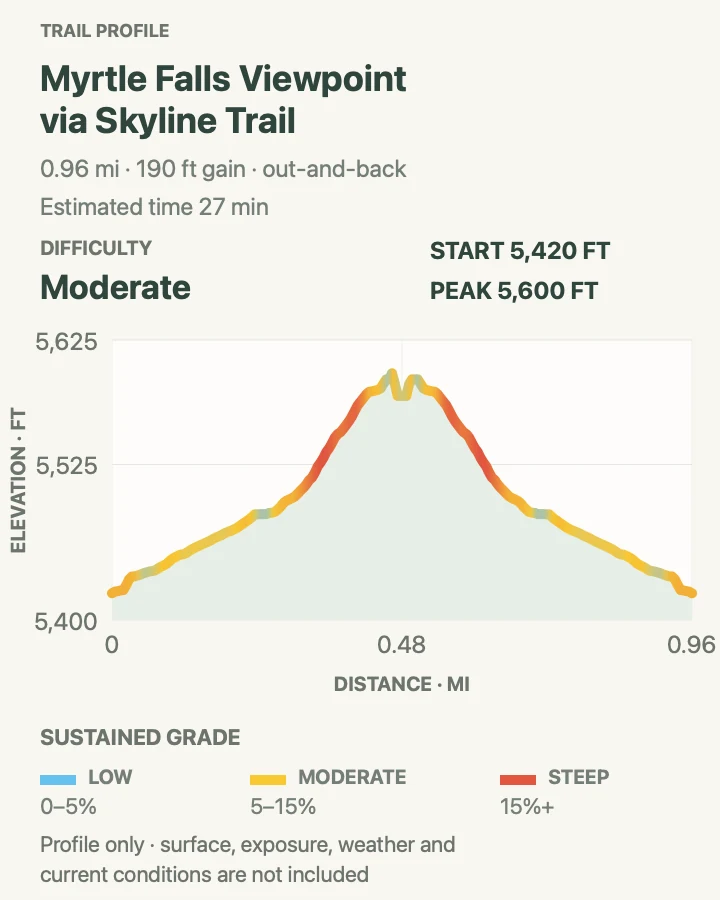
The paved Skyline path climbs from the visitor center to Myrtle Falls and Edith Creek in about half a mile. NPS gives the round trip 100 feet of gain and an average time of 35 minutes; the reviewed profile records roughly 190 feet once small ups and downs are counted. The grade is noticeable, but the route is suitable for wheelchairs with help and for strollers in favorable conditions.
The classic photograph looks across the falls toward Mount Rainier. That composition tempts people toward meadow edges, so wait for room at the signed viewpoint instead of stepping around the rail or onto vegetation. If weather is improving and the group still has energy, continue only with a clear destination; wandering up Golden Gate can turn the short outing into part of Skyline Loop.
What helps on this route
- Low cloud can hide the mountain while leaving the falls worthwhile; check the Paradise webcam before driving up.
- The path can be icy or snow-covered outside the main summer window despite its paved surface.
Terrain and access: Steep paved path, busy junctions, subalpine meadow, wet spray near the falls, possible snow or ice, and about 100–190 feet of climbing depending on the measured line.

Skyline Loop
- Distance
- About 5.5 miles by NPS; 5.7 miles on the reviewed loop
- Elevation gain
- 1,820 feet
- Time
- 4 hr 18 min
- Difficulty
- Hard
- Route type
- loop
- Parking
- Start beside the visitor center in the upper Paradise lot; arrive outside the mid-day rush or expect overflow parking.
- Best time
- A stable midsummer morning after the upper route is snow-free, or with appropriate snow travel experience.
- Pets
- Pets are prohibited on Skyline and all connecting park trails.
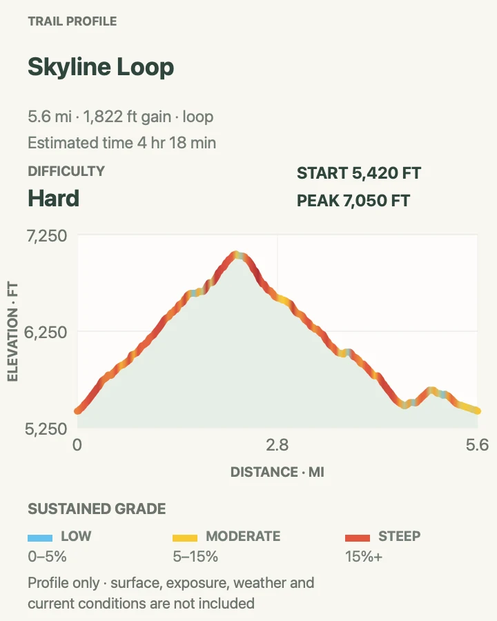
Skyline earns its reputation in the first mile: the paved trail keeps climbing past Myrtle Falls and into open meadow. The western side reaches Glacier Vista, while the high route rises to Panorama Point before curling through a rougher, more exposed basin. NPS estimates about 1,700 feet of gain and four and a half hours. The reviewed track records about 1,820 feet.
Panorama Point is a complete turnaround when weather closes the upper loop. Continuing makes sense only when the constructed line is visible and the party is equipped for remaining snow. Do not skirt a snowfield through flowers. The mountain can go from clear to whiteout quickly, and the broad upper ground offers fewer visual anchors than the crowds below suggest.
Clockwise and counterclockwise both work. A clockwise start through Myrtle Falls puts much of the steep climbing early; the western approach reaches Glacier Vista sooner. Choose from current snow and wind rather than a rule copied from a summer itinerary.
What helps on this route
- Carry the Paradise trail map because several connectors can shorten the loop without requiring an improvised cross-meadow line.
- Treat the seasonal toilet at Panorama Point as unavailable until confirmed; start with water and a complete day kit.
Terrain and access: Pavement low on the route, steep meadow trail, rock, exposed high basin, possible persistent snow, rapid weather, roughly 1,800 feet of climbing, and many signed junctions.

Bench and Snow Lakes Trail
- Distance
- 2.5 miles by NPS; about 2.3 miles on the reviewed out-and-back
- Elevation gain
- 620 feet
- Time
- 1 hr 9 min
- Difficulty
- Moderate
- Route type
- out-and-back
- Parking
- Use the roadside trailhead on the south side of Stevens Canyon Road, 1.5 miles east of Reflection Lakes.
- Best time
- Mid- to late summer after Snow Lake melts out, or fall for mountain ash and huckleberry color.
- Pets
- Pets are prohibited on the trail.
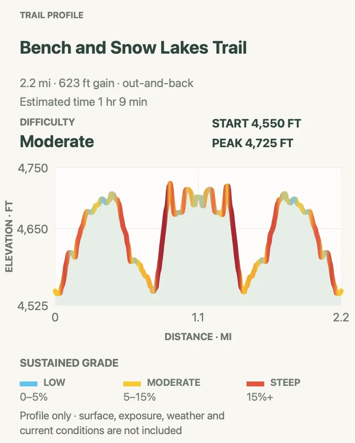
This route is short on paper and surprisingly lumpy underfoot. It crosses several low ridges, reaches Bench Lake after roughly three-quarters of a mile, then continues to Snow Lake in a cirque below the Tatoosh Range. The profile's repeated rises and dips explain why NPS assigns about 700 feet of total gain rather than a simple low-grade stroll.
Bench Lake is a good turnaround when time is short. Snow Lake supplies the stronger sense of enclosure, but it can stay icy into July and its small wilderness camp requires a permit for an overnight stay. Black bears may use the berry-rich slopes. Keep food controlled, give wildlife room, and treat water before drinking.
What helps on this route
- Roadside parking is limited; do not create a new pullout or leave wheels in the travel lane.
- Carry traction only when current reports and your experience support using it; equipment does not make a hazardous snow slope safe.
Terrain and access: A sequence of forested low ridges, roots and dirt, two subalpine lakes, late snow, possible black bears, and about 600–700 feet of cumulative ascent.

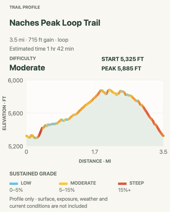
Naches Peak Loop Trail
- Distance
- 3.4 miles by NPS; 3.5 miles on the reviewed loop
- Elevation gain
- 720 feet
- Time
- 1 hr 42 min
- Difficulty
- Moderate
- Route type
- loop
- Parking
- Park at Tipsoo Lake about half a mile west of Chinook Pass on SR 410; a Chinook Pass start is also possible when open.
- Best time
- Late summer for meadows and lakes, or early fall for huckleberry color and clearer air.
- Pets
- Do not bring a pet on the complete loop; pets are allowed only on the outside-park Pacific Crest Trail half.
Hike clockwise from Tipsoo Lake toward Chinook Pass to save the strongest Mount Rainier views for the southern half of the loop. The route joins the Pacific Crest Trail, rounds Naches Peak through subalpine meadow, and returns past small lakes. NPS lists 500 feet of gain; the reviewed profile records about 715 feet across all the undulations.
Naches Peak is separate from the Sunrise trailhead even though both sit in the park's northeast planning area. During the current fire closure, NPS still lists Naches Peak and the PCT from Chinook Pass without a trail closure, but access can change with fire behavior and highway restrictions. Check SR 410 and park alerts immediately before leaving.
What helps on this route
- Clockwise travel places Mount Rainier ahead on the return half rather than behind you.
- Stay on the path through meadow even when a muddy edge makes the inside of a switchback look easier.
Terrain and access: Subalpine meadow, short forest stretches, small lakes, moderate ridge travel, seasonal snow, limited shade, and roughly 500–700 feet of cumulative climbing.

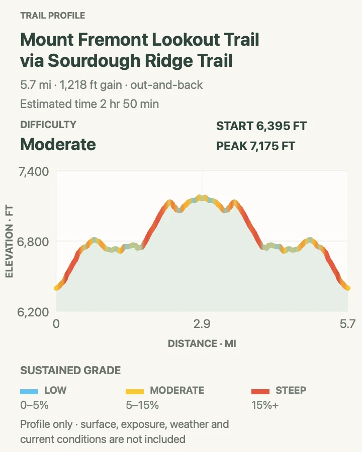
Mount Fremont Lookout via Sourdough Ridge
- Distance
- 5.6 miles by NPS; about 5.8 miles on the reviewed out-and-back
- Elevation gain
- 1,220 feet
- Time
- 2 hr 50 min
- Difficulty
- Moderate
- Route type
- out-and-back
- Parking
- Normally starts on the north side of the Sunrise lot. Sunrise Road and the trail are closed under the current August 2026 fire order.
- Best time
- After the fire closure is lifted, on a clear summer or early-fall day when Sunrise Road and the trail are open.
- Pets
- Pets are prohibited on the trail.
From Sunrise, Sourdough Ridge climbs to a five-way junction beside Frozen Lake. The Mount Fremont branch then traverses rocky ground for another 1.3 miles to the historic lookout. Nearly the whole hike sits in meadow or on open crags, with little shelter from wind, lightning, or intense sun.
NPS gives the route 900 feet of gain and about three hours. The reviewed line records roughly 1,220 feet as it follows the ridge's smaller rises. There is no camping at or around the lookout. Stay on tread around the building and on the return; the plants above 6,000 feet have a short growing season and scars linger.
Do not attempt to walk in from a closure boundary. As of August 29, NPS lists Mount Fremont closed and Sunrise Road shut until further notice. A map and an old trip report do not override the emergency regulation.
What helps on this route
- Save this route for a post-closure day and reread the live trail table before driving toward the northeast entrance.
- Carry sun protection, insulation, and more water than the moderate mileage alone would suggest.
Terrain and access: High subalpine meadow, rocky ridge, exposed traverses, wind and lightning exposure, little shade, seasonal snow, and roughly 900–1,200 feet of cumulative ascent.

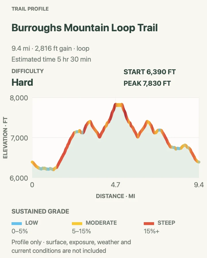
Burroughs Mountain Loop
- Distance
- NPS lists 4.7 miles to First and 7 miles to Second Burroughs; the reviewed longer loop is about 9.6 miles
- Elevation gain
- 2,820 feet
- Time
- 5 hr 30 min
- Difficulty
- Hard
- Route type
- loop
- Parking
- Normally begins at Sunrise. Sunrise and White River roads and their originating trails are closed under the current August 2026 fire order.
- Best time
- After the closure ends, during the short snow-free high-country season on a calm, clear morning.
- Pets
- Pets are prohibited on the trail.
The standard clockwise approach follows Sunrise Rim past Shadow Lake, then climbs sharply above the White River and Emmons Glacier to broad First Burroughs. Second Burroughs lies another 0.7 mile west. Either peak can be the day's endpoint, and NPS gives the two established round trips as 4.7 and 7 miles.
Our reviewed map follows a longer 9.6-mile loop with about 2,800 feet of cumulative climbing. It should be read as the hard extension, not as a correction to the park's shorter options. Turn at First Burroughs when snow, wind, time, or legs argue for it. Second Burroughs is already a complete high-country day for many hikers.
The plateau looks durable but supports fragile tundra-like vegetation. Remain on the constructed line, especially where people have braided the route toward a photograph. Early-season snow can cover steep side slopes well after Sunrise Road opens. Current access is simpler: it is closed, and the trip waits.
What helps on this route
- Choose First, Second, or the long loop before leaving Sunrise, then reassess at each signed junction.
- Do not use the 9.6-mile profile to budget the NPS seven-mile turnaround; they are different itineraries.
Terrain and access: Subalpine meadow, steep climb, broad alpine plateau, exposed tundra-like ground, seasonal snow, wind, limited water, and roughly 2,800 feet of ascent on the reviewed long loop.

Official planning sources
Trail access and safety details were checked against these National Park Service pages. The maps and profiles use the reviewed route geometry stored with this guide.
- NPS: Current Mount Rainier alerts and fire closures
- NPS: Current trail and backcountry camp conditions
- NPS: 2026 timed-entry and congestion guidance
- NPS: Paradise hiking, snow, and meadow guidance
- NPS: Bench and Snow Lake Trail
- NPS: Naches Peak Loop map and statistics
- NPS: Mount Fremont Lookout Trail
- NPS: Burroughs Mountain Trail
- NPS: Mount Rainier fees and no timed entry in 2026
Map data © OpenStreetMap contributors. Trail geometry and planning details include National Park Service public information.