6 Best Hikes in the National Park of American Samoa
Six distinctive American Samoa hikes with reviewed terrain maps, elevation profiles, island-by-island access notes, and current NPS planning links.
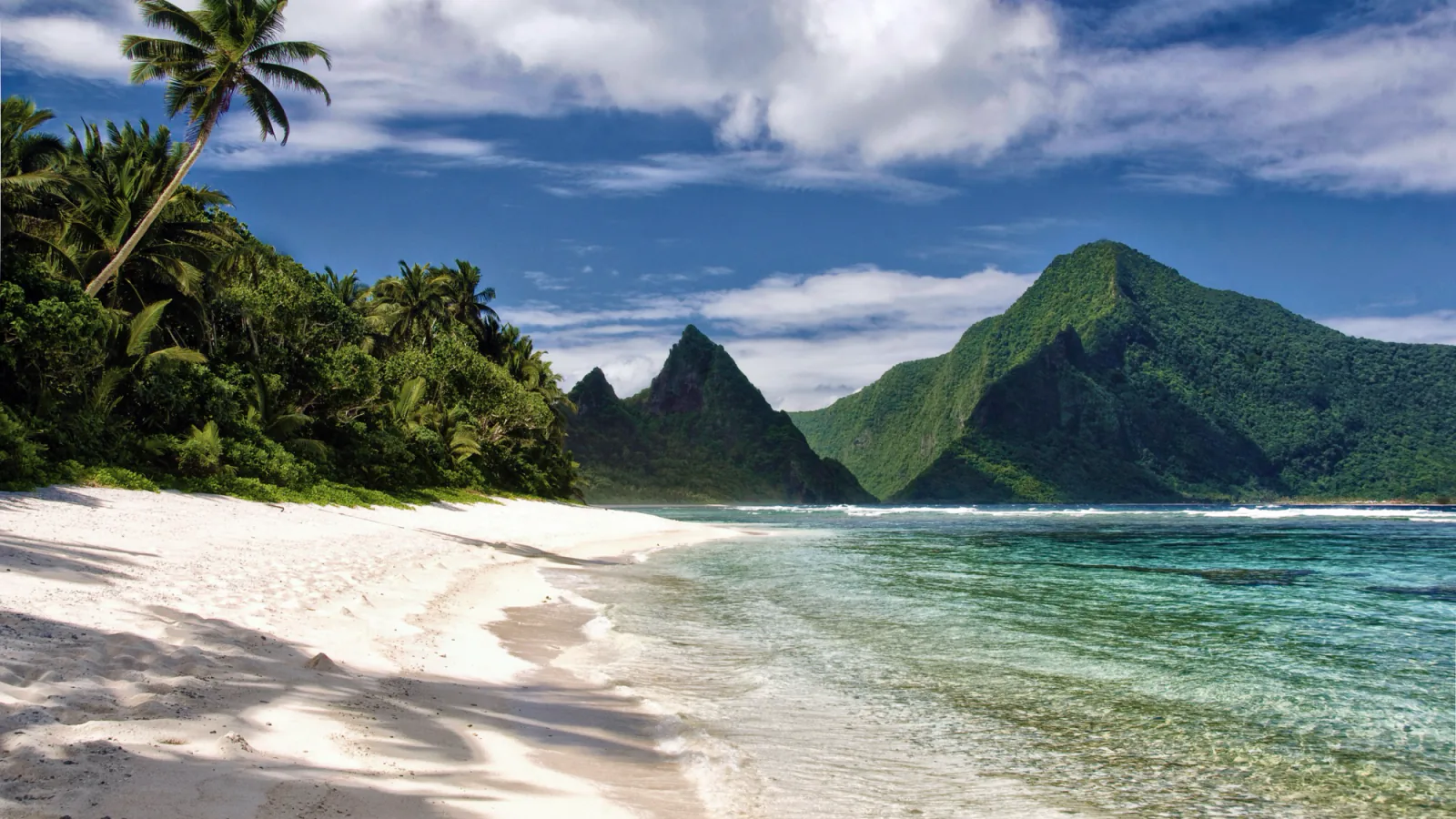
Hiking here starts with geography. The national park protects land on Tutuila, Ofu, and Ta‘u, and the six routes in this guide are not gathered around one visitor center. Five are on Tutuila. Si‘u Point is on Ta‘u, where flights, local transport, and weather can decide whether the hike happens at all.
This is the complete set of distinct four-star routes in the reviewed local source, not a padded countdown. Mount ‘Alava supplies the classic ridgeline day; Lower Sauma and Pola fit into shorter windows; Tuafanua and the Adventure Trail demand comfort with steep, wet terrain; Si‘u Point rewards the extra work of reaching Ta‘u. The order follows trip planning and trail character rather than public review totals.
Official trail information was checked on August 29, 2026. A current NPS alert closes the Mount ‘Alava and Fatifati routes from Fagasa Pass to the summit for trail improvements until further notice. NPS identifies Old Vatia as a steeper, more rugged way toward ‘Alava, but that is not a casual substitute for the closed route. Rain falls in every season, village customs affect access, and Tuafanua is closed on Sundays. Recheck the alert or call the park before leaving dependable service.
What changes a hiking day here
Plan by island before choosing a trail
Mount ‘Alava, Lower Sauma, Tuafanua, Pola, and the Adventure Trail are on Tutuila. Si‘u Point is on Ta‘u and requires separate inter-island travel plus a local ride to the trail area. Do not place it into a casual Tutuila day plan because the distance looks similar on a list.
Do not route around the current Mount ‘Alava closure casually
The standard Fagasa Pass route to Mount ‘Alava is closed for improvement work until further notice. NPS mentions Old Vatia as a much steeper and more rugged alternative, not as an equivalent detour. Confirm that route and any connection to the Adventure Trail directly with park staff before setting out.
Use the drier months, but still pack for rain
May through October is generally the drier season, and mornings are usually cooler. Sudden rain can turn roots, volcanic soil, ladders, and steep steps slick at any time of year. Carry water, rain protection, insect repellent, and a downloaded map; facilities along these routes are limited.
Village etiquette is part of trail access
Some routes cross village or privately used land. Stay on the established line, dress respectfully, ask before photographing people or using a village beach, and follow local instructions. Sunday observance is important throughout American Samoa; Tuafanua is specifically closed on Sundays, and other access may also be restricted.
Treat ocean edges as hazards, not swimming stops
Tuafanua reaches a rocky coast where NPS warns of dangerous waves and currents. Remain on land and do not turn the beach into a swim break. Pola also reaches sensitive coastal habitat used by nesting seabirds; give birds and cliff edges room.
Read the map mileage notes carefully
Two local lines cover something different from the rounded NPS figure. The Pola map includes the rough approach to the official 0.1-mile signed trail. The Tuafanua graphics cover a reviewed 1.2-mile recorded section, while NPS describes a 2.2-mile full route. Those distinctions are labeled below instead of being blended into one misleading number.
| Trail | Distance | Time | Difficulty | Best for |
|---|---|---|---|---|
| Mount ‘Alava Trail | 7 miles round trip by NPS; about 7.3 miles on the reviewed track | 4 hr 30 min | Hard | The park’s classic long rainforest ridge and broad island views |
| Lower Sauma Ridge Trail | 0.4 mile round trip | 1 hr | Moderate | A short climb pairing archaeology with a dramatic coastal overlook |
| Tuafanua Trail | 2.2 miles for the full NPS route; the reviewed map and profile cover a 1.2-mile recorded section | 58 min | Hard | Experienced hikers comfortable with ladders, ropes, steep grades, and an exposed rocky coast |
| Si‘u Point Trail | 5.7 miles round trip by NPS; about 5.4 miles on the reviewed track | 2 hr 30 min | Moderate | A remote coastal-forest day on Ta‘u with cultural and geographic context |
| Pola Island Trail | The signed NPS trail is 0.1 mile round trip; the reviewed 0.78-mile line includes the rough approach | 1 hr | Easy | A brief close view of Pola Island, sea cliffs, and nesting-bird habitat |
| Mount ‘Alava Adventure Trail | 5.6 miles by NPS; about 5.7 miles on the reviewed loop | 3 hr 58 min | Strenuous | The park’s most demanding marked route, with sustained ridge travel and dozens of ladders |
Mount ‘Alava Trail
- Distance
- 7 miles round trip by NPS; about 7.3 miles on the reviewed track
- Elevation gain
- 2,710 feet
- Time
- 4 hr 30 min
- Difficulty
- Hard
- Route type
- Out and back
- Parking
- Begin at the signed trailhead at Fagasa Pass on the road between Pago Pago and Fagasa; park without narrowing the road or blocking local access.
- Best time
- After NPS lifts the current Fagasa Pass closure; then use an early dry-season morning with a full day available.
- Pets
- Current online guidance is not route-specific; confirm with park staff before bringing a pet.
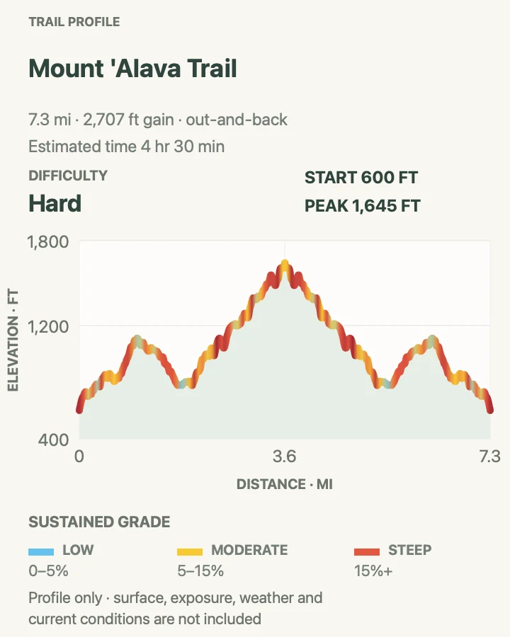
The standard Mount ‘Alava route from Fagasa Pass is currently closed for trail improvement work. Do not use the map below to enter the closure. When open, the old communications road climbs through upland rainforest onto the long spine above Pago Pago Harbor. It is the less technical of the park’s two long ‘Alava routes, but the repeated ridge rises add up. The reviewed line records roughly 7.3 miles and more than 2,700 feet of accumulated climbing.
Cloud can erase the summit view even when the coast looks clear at breakfast. The forest, old road, and changing glimpses into the harbor still make the walk worthwhile, but start early enough to wait briefly for a break without risking a late return. Wet grass and mud can make the descent slower than the climb.
What helps on this route
- Check the NPS alert for an explicit reopening before using the Fagasa Pass trailhead.
- Turn around if thunder, heavy rain, or fading daylight arrives before the upper ridge.
Terrain and access: Old road and rainforest track with long rolling grades, exposed roots, mud, ridge crossings, and steep accumulated climbing.

Lower Sauma Ridge Trail
- Distance
- 0.4 mile round trip
- Elevation gain
- 230 feet
- Time
- 1 hr
- Difficulty
- Moderate
- Route type
- Out and back
- Parking
- Use the signed roadside trail area and fale near Vatia, leaving room for village traffic and following any local parking direction.
- Best time
- A clear morning when Vai‘ava Strait and Pola Island are visible from the ridge.
- Pets
- Pets are not allowed on this trail under the current NPS route guidance.
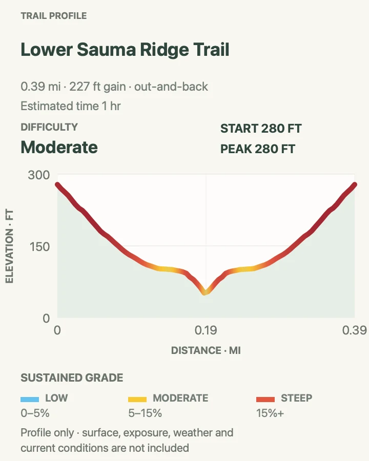
Lower Sauma is short enough to fit beside another Vatia walk, yet it gains its view honestly. The path climbs from the roadside fale to an archaeological star mound on the ridge. Openings look toward Vai‘ava Strait and the steep sea stack of Pola Island.
NPS describes a gentle climb and lists about 232 feet of gain; the reviewed line is 0.39 mile and shows a similar rise. That is a concentrated slope for a very short trail. Heat and wet footing matter more than the mileage suggests, especially on the return downhill.
What helps on this route
- Do not step onto or rearrange stones at the archaeological site.
- Pair the trail with Pola only after confirming road and village access in Vatia.
Terrain and access: Short tropical forest path with a sustained ridge climb, roots, damp soil, an archaeological site, and an exposed coastal viewpoint.

Tuafanua Trail
- Distance
- 2.2 miles for the full NPS route; the reviewed map and profile cover a 1.2-mile recorded section
- Elevation gain
- 580 feet
- Time
- 58 min
- Difficulty
- Hard
- Route type
- Out and back
- Parking
- In Vatia, follow the current NPS trailhead direction near Mount ‘Alava Elementary School and park only where village access remains clear.
- Best time
- A dry weekday morning; the trail is closed on Sundays.
- Pets
- The current NPS activity page permits pets, but the ladders and ropes may make this route impractical; verify conditions first.
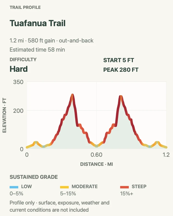
Tuafanua drops and climbs through rainforest on ladders, built steps, and rope-assisted sections before reaching a rocky beach. NPS gives 2.2 miles, 219 feet of net elevation change, and two to three hours for the full outing. Trekking poles help on the ordinary tread but must be stowed where both hands are needed.
The graphics below show the locally recorded 1.2-mile section, not the entire NPS route. Its profile accumulates considerably more climbing because the trace follows repeated steep turns. At the coast, stay on land: waves and currents are dangerous, and a calm-looking interval is not permission to swim.
What helps on this route
- Do not plan Tuafanua for Sunday; the closure is part of the park’s current written policy.
- Keep three points of contact on ladders and turn around before wet equipment or fatigue makes the return unsafe.
Terrain and access: Steep rainforest singletrack, ladders, constructed steps, fixed ropes, roots, muddy slopes, and a rough wave-exposed beach.

Si‘u Point Trail
- Distance
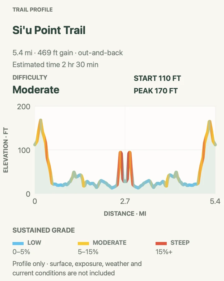
- 5.7 miles round trip by NPS; about 5.4 miles on the reviewed track
- Elevation gain
- 470 feet
- Time
- 2 hr 30 min
- Difficulty
- Moderate
- Route type
- Out and back
- Parking
- On Ta‘u, arrange local transport to the signed route near Saua and confirm where a vehicle can wait without using private land.
- Best time
- A dry, early start after inter-island travel and ground transport are firmly arranged.
- Pets
- Route-specific online pet guidance was not found; ask park staff and local hosts before bringing an animal.
Si‘u Point follows an old road from the Saua area toward the southeast tip of Ta‘u. The pleasure is in the changing coast, forest, and isolation rather than a single summit. The reviewed out-and-back measures about 5.4 miles, close to the park’s rounded 5.7-mile figure, with a series of low rises along the way.
Reaching the trail is the difficult part. Flights and boats between islands are limited, weather-dependent, and not synchronized around a hiking itinerary. Build the day with a local host or park contact, confirm the return ride, carry everything needed, and treat cultural sites with the same care as the natural landscape.
What helps on this route
- Confirm inter-island transport, trail access, and the return vehicle before committing to the day.
- Download the Ta‘u map and leave a return time with someone local; do not assume mobile service.
Terrain and access: Remote old road and coastal forest track with modest rolling grades, humid exposure, cultural sites, and limited services.

Pola Island Trail
- Distance
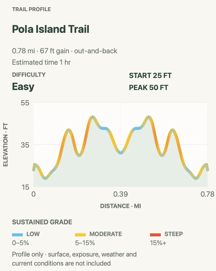
- The signed NPS trail is 0.1 mile round trip; the reviewed 0.78-mile line includes the rough approach
- Elevation gain
- 65 feet
- Time
- 1 hr
- Difficulty
- Easy
- Route type
- Out and back
- Parking
- Drive the narrow gravel access beyond the last house in Vatia only as conditions allow, then park at the turnaround without blocking the single lane.
- Best time
- Morning in dry weather, when the rutted access is easier to judge and seabirds are active.
- Pets
- Pets are allowed under the current NPS route guidance; keep them controlled around village dogs, wildlife, and cliff edges.
The official signed walk is only a tenth of a mile and usually takes fifteen to thirty minutes. Getting to that sign is the larger variable. The last access road is rough, narrow, and affected by ruts and roots, so some visitors will walk farther than the formal trail mileage suggests.
That is why the reviewed map measures 0.78 mile: it includes the approach as well as the signed segment. Its corrected elevation profile follows the low coastal route rather than sampling the adjacent volcanic cliff. At the end, look across to Pola Island without approaching nesting birds or unstable edges.
What helps on this route
- If the access road looks unsuitable for the vehicle, stop only where parking is clearly permitted and walk the remainder.
- Use a long lens for seabirds and remain on the established path.
Terrain and access: Rough single-lane gravel approach followed by a very short low coastal trail with roots, ruts, forest shade, seabird habitat, and sea-cliff views.

Mount ‘Alava Adventure Trail
- Distance
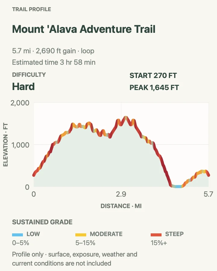
- 5.6 miles by NPS; about 5.7 miles on the reviewed loop
- Elevation gain
- 2,690 feet
- Time
- 3 hr 58 min
- Difficulty
- Strenuous
- Route type
- Loop
- Parking
- Use the signed Vatia trail access near Lower Sauma and follow current village parking instructions; do not block the road or fale.
- Best time
- Very early on a dry day, with a capable companion and ample daylight.
- Pets
- Current online guidance is not route-specific; the ladders and steep ridges make this a poor pet route, so confirm with park staff.
The Adventure Trail earns its name through quantity, not a single stunt. NPS counts 56 ladders and 783 steps as the route crosses steep rainforest ridges and connects the Mount ‘Alava high country with Vatia. The reviewed loop is about 5.7 miles, with roughly 2,800 feet of accumulated ascent packed into repeated climbs.
This is not the trail to test immediately after rain or late in the day. Every steep descent must still be climbed or negotiated farther around the loop, and wet ladder rungs change the risk quickly. The current alert closes the Fagasa Pass routes and describes Old Vatia as a possible but much tougher approach; confirm that the full Adventure connection is open before relying on it.
What helps on this route
- Ask park staff whether the current Mount ‘Alava work affects any part of the intended loop before leaving Vatia.
- Keep the group together; one person should not disappear over a ridge or ladder while another is still negotiating the previous section.
Terrain and access: Very steep rainforest ridges, 56 ladders, hundreds of steps, roots, mud, narrow crests, and repeated high-effort climbs.

Official planning sources
Trail access and safety details were checked against these National Park Service pages. The maps and profiles use the reviewed route geometry stored with this guide.
- NPS: National Park of American Samoa trail descriptions
- NPS: Hiking conditions, climate, and village access
- NPS: Current park conditions and alerts
- NPS: Park laws, policies, and Sunday trail closures
- NPS: General safety in American Samoa
- NPS: Mount ‘Alava route information
- NPS: Tuafanua Trail current trip details
- NPS: Lower Sauma Ridge current trip details
- NPS: Pola Island Trail current trip details
- NPS: Visitor guide and cultural etiquette
Map data © OpenStreetMap contributors. Trail geometry and planning details include National Park Service public information.