22 Best Hikes in Theodore Roosevelt National Park
Twenty-two Theodore Roosevelt hikes across the South, North, and Elkhorn Ranch units, with custom terrain maps, elevation profiles, access notes, and live NPS alerts.
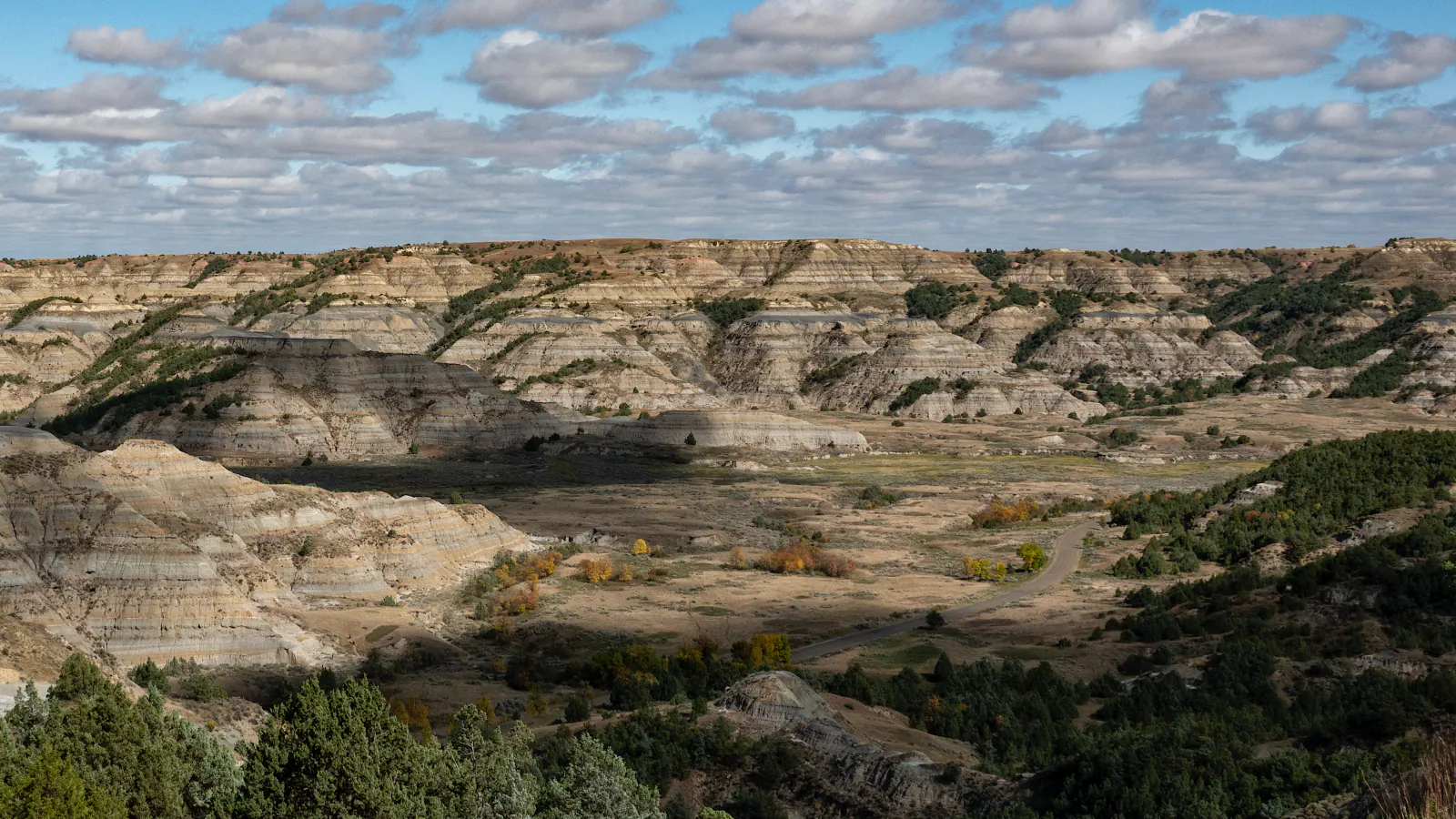

Theodore Roosevelt is three separate parks in practical terms. The South Unit begins at Medora and holds the busiest scenic-road trailheads. The North Unit sits 68 road miles away beside US 85 and keeps Central Time while the South Unit keeps Mountain Time. Elkhorn Ranch is a third, undeveloped unit reached by a long drive on gravel roads. Treating all three as one compact stop is the easiest way to lose a day to driving.
These twenty-two routes are arranged by unit and then by the kind of day they require. Short South Unit walks come first, followed by Painted Canyon and the longer South Unit network. The North Unit progresses from river-bottom and prairie walks to Buckhorn and Achenbach. Elkhorn Ranch closes the guide because it needs its own road plan. Distances on the trail cards follow the mapped route lines used to make the terrain views and measured profiles, so they sometimes differ from rounded NPS sign distances.
Official trail, road, and safety information was checked on August 29, 2026. NPS still identifies Ridgeline Nature Trail as inaccessible because of the South Unit road collapse, so it is not recommended here. Clay, river depth, wildlife, fire restrictions, and road access can change much faster than an article. Read the live alert and weather panels again before leaving service, then ask a ranger about any river-dependent or all-day route.
Live park weather
Theodore Roosevelt National Park
South Unit Visitor Center
Loading the latest conditions and alerts…
What changes a hiking day here
Give each unit its own block of time
North and South are 68 road miles apart, and the North Unit is one hour ahead because it observes Central Time. Elkhorn Ranch is roughly a 1.5-hour drive from Medora in good conditions. A South Unit morning, North Unit afternoon, and Elkhorn detour do not fit together cleanly. Plan separate half-days or full days and download directions before leaving town.
The road loop is open, but Ridgeline is not
NPS reopened the complete South Unit Scenic Loop Drive after the major repair finished in November 2025. Its current South Unit page still identifies Ridgeline Nature Trail as inaccessible because of a road collapse. Do not infer that the trail reopened with the through-road. Check live alerts for temporary weather, wildlife, fire, or maintenance closures at other pullouts.
Carry the water instead of planning around a creek
NPS advises about one liter per person per hour for hiking in the badlands. Backcountry water sources are scarce and none are approved for drinking; natural water must be treated or boiled. Summer temperatures can reach the 90s and above with little shade. Long Paddock, Talkington, Buckhorn, and Achenbach days need their full water supply from the start.
Rain rewrites the footing
Bentonite clay absorbs water, becomes slick, and can build up under boots until tread loses traction. Some routes remain difficult for days after a storm. Turn away from steep clay when it is wet, and avoid unpaved Elkhorn and Petrified Forest access roads after rain until a ranger confirms their condition. Sudden lightning, hail, strong wind, and sharp temperature changes are also normal badlands weather.
Bison control the trail
Stay at least 25 yards from bison, elk, and feral horses, and add distance whenever an animal changes its behavior. Bison often use the same narrow trail a hiker wants. Step away early where terrain permits, wait, or turn around; never squeeze between an animal and a drop, creek, calf, or group. Prairie dog burrows can also shelter rattlesnakes and black widow spiders.
Ask about every planned river crossing
Big Plateau and the full Achenbach circuit depend on Little Missouri River conditions, and NPS specifically tells hikers to check current depths. A low crossing on one visit can be deep, muddy, or fast after rain upstream. Do not let a mapped line overrule the water in front of you. Carry a dry turnaround plan and do not enter a crossing you cannot reverse.
Day hiking and overnight travel have different paperwork
These day routes do not need backcountry camping permits. Any overnight trip does. The free permit comes from the South Unit Visitor Center for South Unit and Elkhorn trips, or the North Unit Visitor Center for North Unit trips; Painted Canyon does not issue them. There are no developed backcountry campsites or approved drinking-water sources.
Leave pets out of the hiking plan
Pets are prohibited on every park trail and throughout the backcountry. Leashed pets are limited to developed areas, parking lots, and within six feet of established roads. That restriction applies to paved nature trails too. Trained service animals are allowed, but handlers should speak with a ranger about bison and route conditions.
| Trail | Distance | Time | Difficulty | Best for |
|---|---|---|---|---|
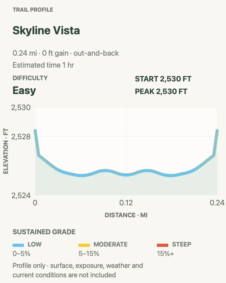
| Skyline Vista | About 0.2 mile round trip | About 10 to 20 minutes | Easy | A nearly level first look across the South Unit |
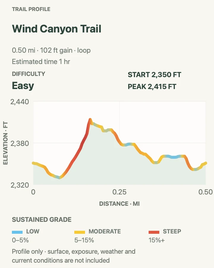
| Wind Canyon Trail | About 0.5 mile loop | 30 minutes to 1 hour | Easy | A short Little Missouri River overlook and sunset walk |
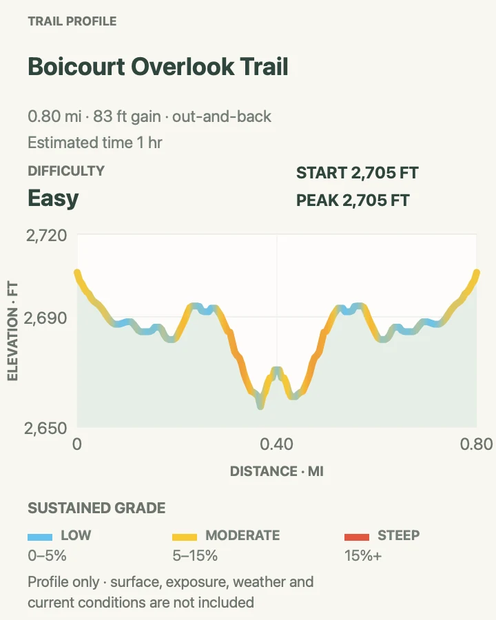
| Boicourt Overlook Trail | About 0.8 mile round trip | 30 minutes to 1 hour | Easy | A gentle South Unit overlook with room to watch wildlife |
| Buck Hill Trail | About 0.4 mile round trip | 30 minutes to 1 hour | Moderate | A very short climb to the park's highest road-accessible point |
| Coal Vein Trail | About 0.8 mile loop | 30 minutes to 1 hour | Easy | A compact geology walk through a former underground-fire site |
| Old East Entrance Station Trail | About 0.9 mile round trip | About 1 hour | Easy | Park history and a prairie dog town on gentle ground |
| Painted Canyon Nature Trail | About 1.1 miles around the loop | 45 minutes to 1 hour | Moderate | A short descent below the Painted Canyon rim |
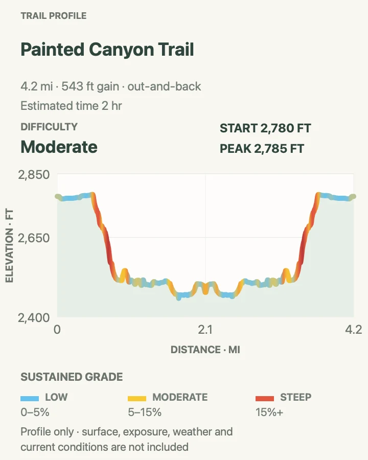
| Painted Canyon Trail | About 4.2 miles round trip | About 2 hours | Moderate | A longer canyon-floor walk with petrified wood and a clear turnaround |
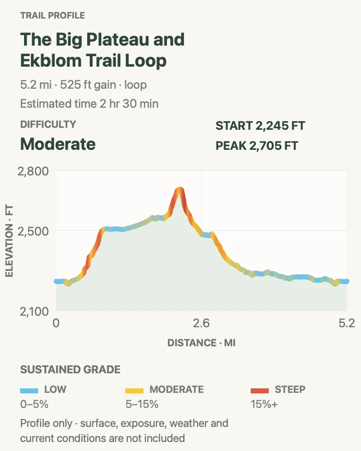
| Big Plateau and Ekblom Trail Loop | About 5.2 miles around the loop | About 2 hours 30 minutes | Moderate | A compact South Unit backcountry loop across the river |
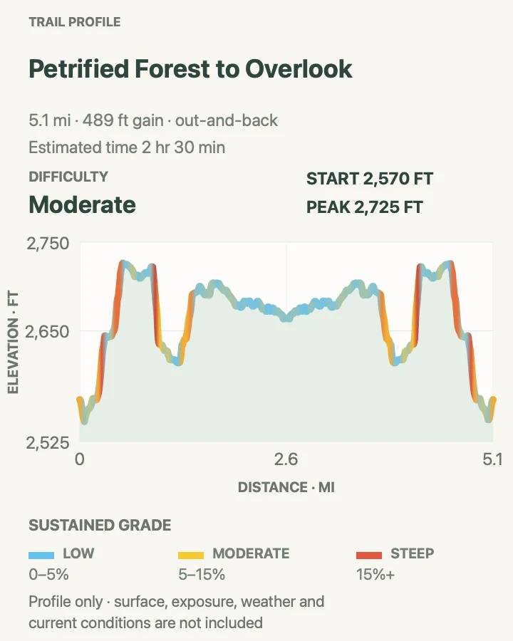
| Petrified Forest to Overlook | About 5.2 miles round trip | About 2 hours 30 minutes | Moderate | Petrified tree stumps and a longer overlook beyond the usual turnaround |
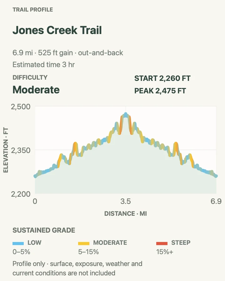
| Jones Creek Trail | About 7 miles round trip | About 3 hours | Moderate | A moderate sample of the South Unit's connected backcountry trail system |
| Lower Paddock Creek Trail | About 7.4 miles round trip | About 3 hours | Moderate | A longer creek-corridor walk without completing the full lower loop |
| Lower Talkington Trail | About 4.7 miles round trip | About 2 hours | Moderate | A shorter entry into the Talkington-Paddock network |
| Upper Talkington Trail | About 7.5 miles round trip | About 3 hours | Moderate | A higher and longer view of the South Unit's eastern backcountry |
| Upper Paddock Creek Trail | About 17.1 miles round trip | About 7 hours | Moderate, with a strenuous distance commitment | An all-day traverse of the eastern backcountry without closing the upper loop |
| Little Mo Trail | About 1 mile around the loop | 30 minutes to 1 hour | Easy | A short North Unit river-bottom walk with an interpretive option |
| Prairie Dog Town via Buckhorn Trail | About 1.9 miles round trip | About 1 hour | Easy | A short walk to a North Unit prairie dog colony |
| Caprock Coulee Loop | About 4.2 miles around the loop | 2 to 3 hours | Moderate | A half-day loop through several North Unit habitats |
| Sperati Point via Achenbach Trail | About 2.4 miles round trip | About 1 hour 30 minutes | Moderate | A practical Sperati Point visit without the full Achenbach loop |
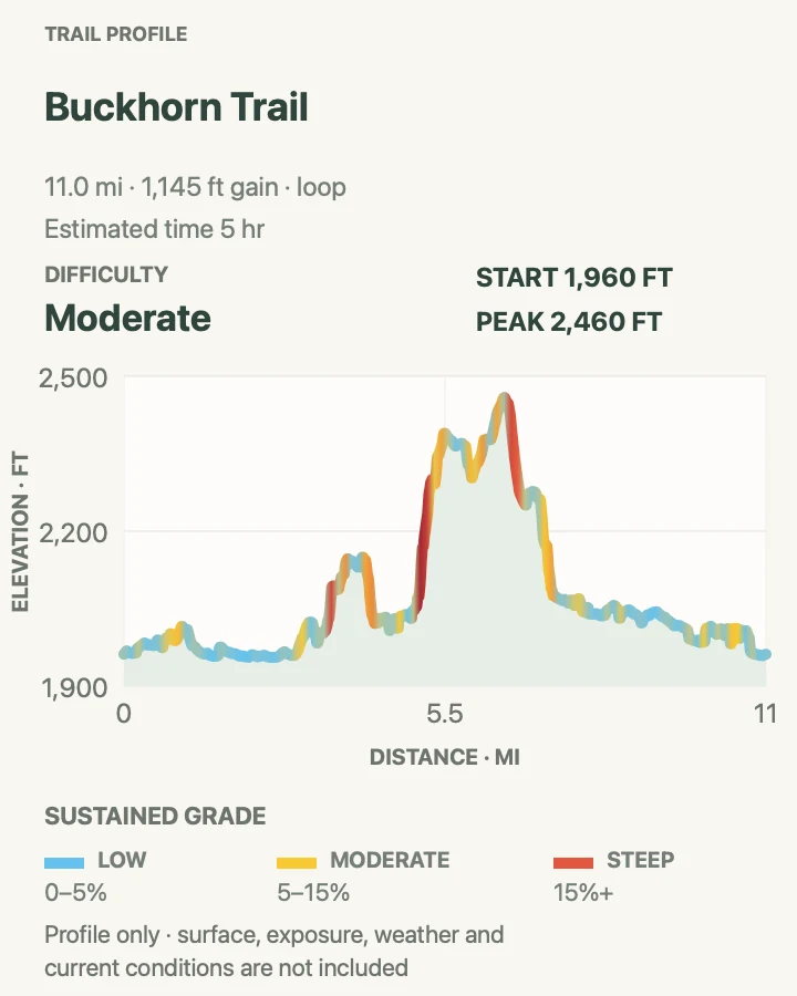
| Buckhorn Trail | About 11.1 miles around the loop | Allow 6 to 8 hours | Moderate to strenuous | A full North Unit circuit through prairie dog towns, canyons, and sagebrush |
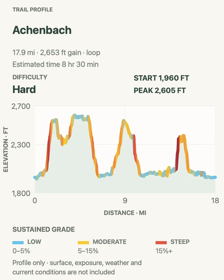
| Achenbach | About 18.1 miles around the loop | Allow 10 to 12 hours | Hard | The North Unit's complete all-day wilderness circuit |
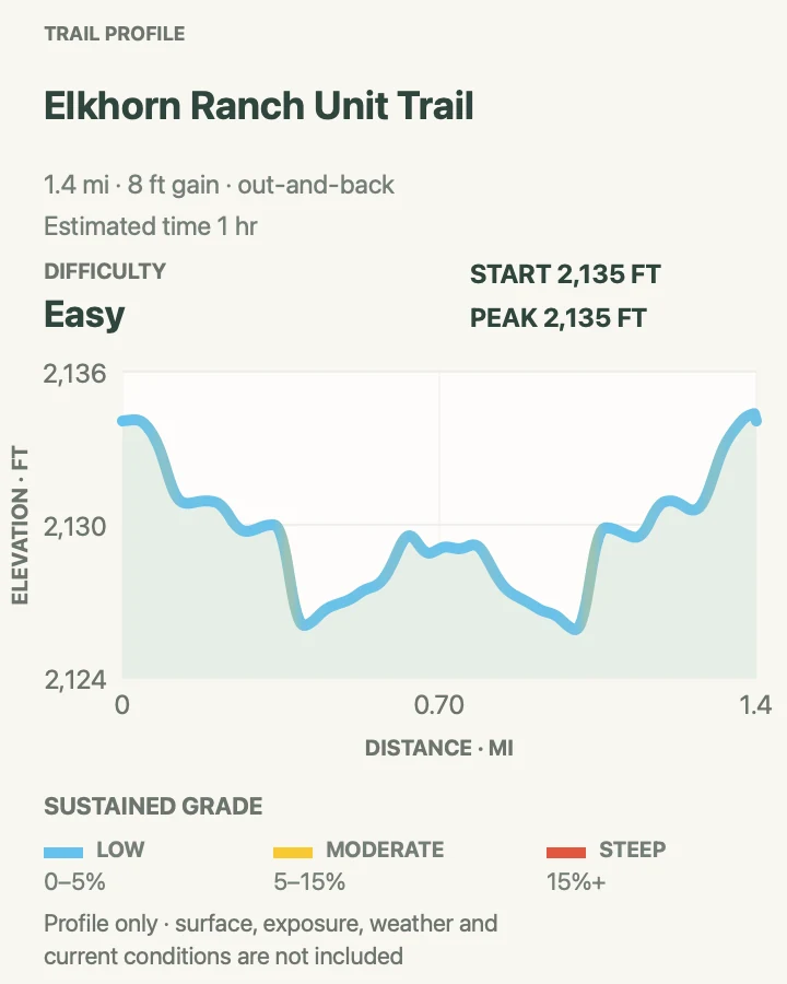
| Elkhorn Ranch Unit Trail | About 1.4 miles round trip | About 1 hour | Easy | Roosevelt's home-ranch site in the Elkhorn Ranch Unit |
Skyline Vista
- Distance
- About 0.2 mile round trip
- Elevation gain
- 0 feet
- Time
- About 10 to 20 minutes
- Difficulty
- Easy
- Route type
- Out and back
- Parking
- Use the signed Skyline Vista pullout on South Unit Scenic Loop Drive.
- Best time
- Early morning for low side light, or a clear evening before the road drive back to Medora.
- Pets
- Pets are not permitted on this trail.
Skyline Vista is the South Unit's smallest useful walk. The paved path crosses Johnson's Plateau to where flat prairie breaks into eroded badlands, and the full mapped walk is about 0.2 mile. The nearly level tread is open to wind and weather. Loose gravel can collect near the pavement edge, and the ground beyond the formal path is fragile. Skyline works well just after entering the unit, before the slower drive to farther trailheads.
What helps on this route
- Park fully inside the marked pullout. Wildlife and two-way traffic leave little room for roadside spillover.
- Keep children on the formal path near the plateau edge, where soft ground can undercut a solid-looking rim.
Terrain and access: Paved, nearly flat path on an exposed plateau with wind and an unguarded badlands edge.

Wind Canyon Trail
- Distance
- About 0.5 mile loop
- Elevation gain
- 100 feet
- Time
- 30 minutes to 1 hour
- Difficulty
- Easy
- Route type
- Loop
- Parking
- Use the signed Wind Canyon parking area beside South Unit Scenic Loop Drive.
- Best time
- Late afternoon for the river view; finish before fading light complicates the stairs and drive.
- Pets
- Pets are not permitted on this trail.
Wind Canyon climbs around a wind-carved opening to a broad South Unit view of the Little Missouri River. Gravel, dirt, and several stair sections turn the half-mile loop into a real walk, yet it remains compact enough to pair with Skyline Vista or Boicourt.
The river bend draws attention west, especially near sunset, but the route also looks down into steep, loose gullies. Keep to the marked tread and allow time for wildlife delays. Bison and feral horses use the river bottoms, and an animal on the path has more claim to the line than a sunset schedule.
What helps on this route
- Carry a light if you start near sunset; the stairs become hard to read before the sky is fully dark.
- Wait at a wide spot if wildlife occupies the trail instead of edging around it above the river.
Terrain and access: Gravel and dirt loop with stairs, short climbs, open wind, loose edges, and little shade.

Boicourt Overlook Trail
- Distance
- About 0.8 mile round trip
- Elevation gain
- 85 feet
- Time
- 30 minutes to 1 hour
- Difficulty
- Easy
- Route type
- Out and back
- Parking
- Use the signed Boicourt Overlook parking area on South Unit Scenic Loop Drive.
- Best time
- Early morning for wildlife in the valley, or evening for long light across the buttes.
- Pets
- Pets are not permitted on this trail.
Boicourt crosses high prairie to a viewpoint above a maze of buttes and drainages. NPS describes the formal overlook path as a short, gentle walk; the route mapped here extends the outing to about 0.8 mile. Follow that line and the signed trail rather than improvising along the rim. The open vantage is useful for spotting bison, horses, or elk at a distance. Descending toward an animal for a closer photograph creates unstable footing and erases the required buffer. Evening light is excellent, but the parking area can fill well before sunset.
What helps on this route
- Bring binoculars so wildlife remains a viewing stop instead of a reason to leave the trail.
- Turn around where the mapped overlook line ends. Social paths along the rim add exposure without a better return route.
Terrain and access: Gentle prairie path to an exposed overlook, with uneven dirt near the rim and almost no shade.

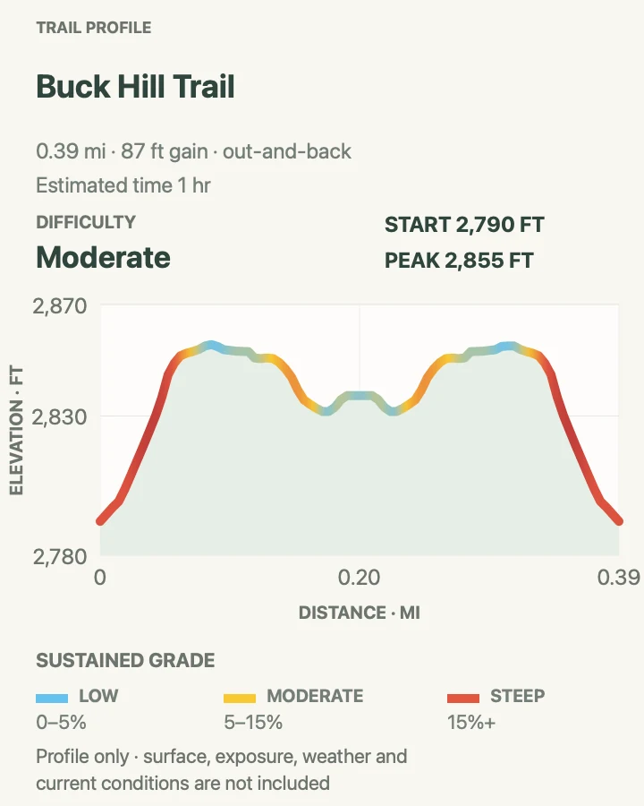
Buck Hill Trail
- Distance
- About 0.4 mile round trip
- Elevation gain
- 85 feet
- Time
- 30 minutes to 1 hour
- Difficulty
- Moderate
- Route type
- Out and back
- Parking
- Use the small signed Buck Hill pullout on South Unit Scenic Loop Drive.
- Best time
- A cool, clear morning before heat and wind strengthen on the exposed top.
- Pets
- Pets are not permitted on this trail.
Buck Hill gains its view quickly. The official path runs about a tenth of a mile each way, rising steeply on stairs to the highest point visitors can reach directly from a park road. The mapped approach and summit section total about 0.4 mile. The top offers no shelter from wind, lightning, or intense sun, so exposure matters more than distance. Watch for horses and bison below, stay off soft cliff margins, and descend before a building storm reaches the plateau.
What helps on this route
- Do not create roadside parking if the small pullout is full. Return after another stop on the scenic drive.
- Check the whole sky before climbing, because the summit offers no cover from lightning or hail.
Terrain and access: Short, steep stair climb to a fully exposed grassy summit with loose edges and strong wind.

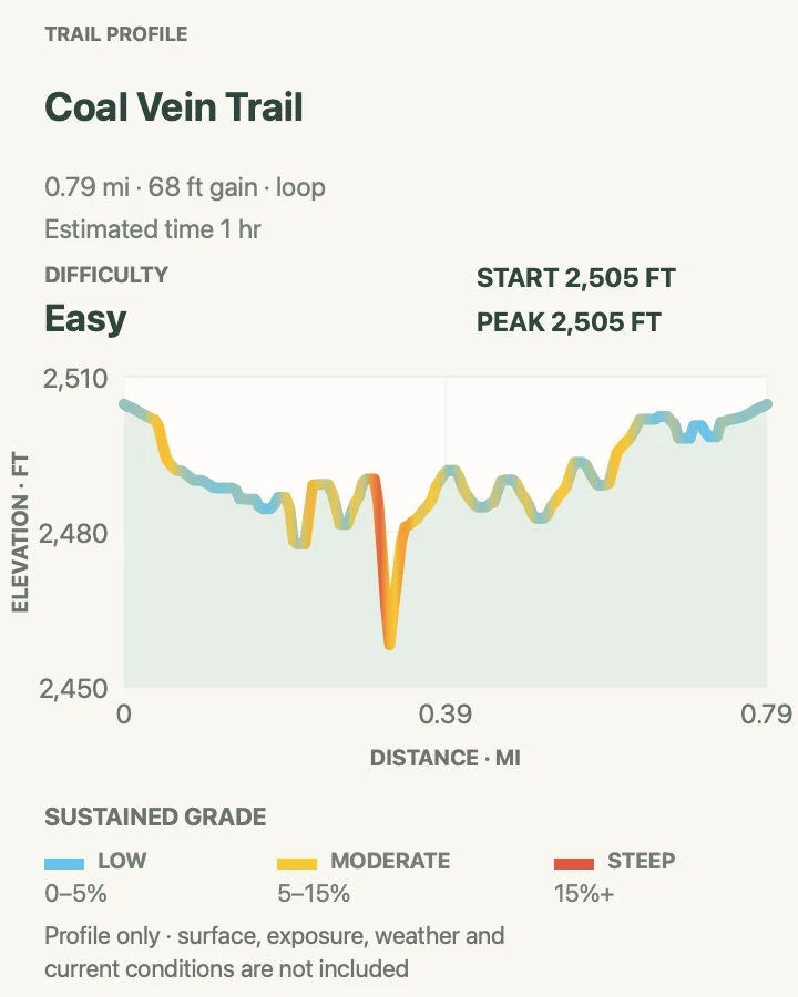
Coal Vein Trail
- Distance
- About 0.8 mile loop
- Elevation gain
- 70 feet
- Time
- 30 minutes to 1 hour
- Difficulty
- Easy
- Route type
- Loop
- Parking
- Use the signed Coal Vein Trail lot on South Unit Scenic Loop Drive.
- Best time
- A dry morning when the stairs and clay are firm.
- Pets
- Pets are not permitted on this trail.
Coal Vein circles terrain altered by an underground coal seam that burned for decades before going out. The fire itself is history, but baked red rock, slumped ground, and the return of vegetation make the loop a useful geology lesson. The outer loop measures about 0.8 mile.
Stairs and short grades keep it from feeling flat, and wet clay can make the small circuit disproportionately awkward. Pick up or download the NPS interpretive brochure if geology is the point of the stop. Anyone seeking a broad overlook will get more from Boicourt or Wind Canyon.
What helps on this route
- Choose the outer loop where signed if you want the full 0.8-mile distance; the inner option is shorter.
- Skip the stairs after rain if clay is packing under your shoes or the first slope feels slick.
Terrain and access: Dirt and clay loop with stairs, eroded slopes, short grades, and exposed geologic features.

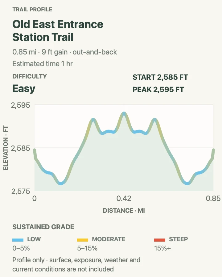
Old East Entrance Station Trail
- Distance
- About 0.9 mile round trip
- Elevation gain
- 10 feet
- Time
- About 1 hour
- Difficulty
- Easy
- Route type
- Out and back
- Parking
- Use the signed trailhead pullout on the east side of the South Unit after confirming current road access.
- Best time
- A dry morning or evening; the old road becomes notably muddy after rain.
- Pets
- Pets are not permitted on this trail.
Old East Entrance follows the park's original road to the historic entrance-station site. The gentle dirt path passes through a prairie dog town, pairing the human story and active colony in a 0.9-mile outing. Mud is the main complication: the old road holds sticky clay after rain, and prairie dog holes make wandering off the tread a poor shortcut. The trailhead lies near the South Unit's altered road corridor, so verify that the pullout is reachable before driving toward it.
What helps on this route
- Stay on the old road through the colony and keep hands and feet away from burrow openings.
- Confirm the trailhead with the live road status. An older paper map may not reflect the road-collapse access pattern.
Terrain and access: Gentle dirt road trace through open prairie, with sticky clay, burrows, and no shade.

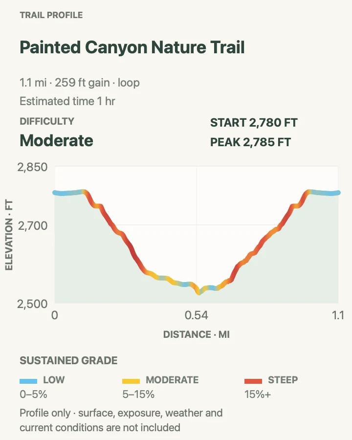
Painted Canyon Nature Trail
- Distance
- About 1.1 miles around the loop
- Elevation gain
- 260 feet
- Time
- 45 minutes to 1 hour
- Difficulty
- Moderate
- Route type
- Loop
- Parking
- Use Painted Canyon Visitor Center and interstate rest-area parking at I-94 Exit 32; this is not the main South Unit entrance.
- Best time
- Morning, before the climb back to the rim becomes hot and the rest area grows busy.
- Pets
- Pets are not permitted on this trail.
Painted Canyon Nature Trail leaves the interstate overlook and drops among layered buttes, junipers, and clay gullies. The 1.1-mile loop is short on a map, but every foot lost from the rim must be regained on the return. Stairs and a steep grade make the Moderate label more honest than the rest-area setting suggests.
Bison frequently reach the Painted Canyon area, including the paths near the visitor center. Scan the slope before descending and be willing to wait at the rim. The loop is separate from the longer Painted Canyon Trail, even though both begin from the same developed stop.
What helps on this route
- Use the restroom and fill water at the visitor-center area before dropping below the rim.
- Save time and energy for the final climb; the first half's descent can hide the effort still owed.
Terrain and access: Steep dirt and clay loop with stairs, loose badlands footing, junipers, and an exposed climb back to the rim.

Painted Canyon Trail
- Distance
- About 4.2 miles round trip
- Elevation gain
- 540 feet
- Time
- About 2 hours
- Difficulty
- Moderate
- Route type
- Out and back
- Parking
- Use Painted Canyon Visitor Center and interstate rest-area parking at I-94 Exit 32.
- Best time
- A cool, dry morning with enough time to climb back before afternoon storms or heat.
- Pets
- Pets are not permitted on this trail.
Painted Canyon Trail takes the longer line from the I-94 rim toward the canyon floor. NPS describes a 4.3-mile trail to the Upper Paddock Creek junction; the mapped out-and-back measures 4.2 miles. Layered rock, scattered juniper, and pieces of petrified bald cypress give the route more range than the nature loop.
The Upper Paddock junction is the clean turnaround for this guide. A faint path continuing north is not an official trail, and the wider network can turn a two-hour outing into a much longer day. Photograph the signed junction and keep the return climb in mind before exploring side terrain.
What helps on this route
- Leave petrified wood exactly where it lies; even a small fragment is a protected park resource.
- Turn back at the mapped Upper Paddock junction unless you planned and supplied for a separate backcountry route.
Terrain and access: Exposed canyon descent and climb on dirt, clay, and loose rock, with junctions into a larger trail network.

Big Plateau and Ekblom Trail Loop
- Distance
- About 5.2 miles around the loop
- Elevation gain
- 520 feet
- Time
- About 2 hours 30 minutes
- Difficulty
- Moderate
- Route type
- Loop
- Parking
- Begin at the signed Peaceful Valley Ranch and Ekblom Trail access in the South Unit.
- Best time
- A dry, cool morning after a ranger confirms Little Missouri River depth.
- Pets
- Pets are not permitted on this trail.
Big Plateau begins with the Ekblom approach from Peaceful Valley Ranch and crosses the Little Missouri River before climbing into the western wilderness.
The butte ascent is the demanding piece; broad prairie walking and long views follow above it. The mapped loop measures 5.2 miles, close to the NPS 5.4-mile planning distance.
The crossing decides the day. Depth, current, mud, and the shape of the banks change with runoff, and the route offers no bridge. Ask at the South Unit Visitor Center before setting out. If the river is unsuitable, switch to a route east of the water rather than hunting for an unofficial ford.
What helps on this route
- Pack sandals or water shoes only for the ford, then change back into supportive shoes before the butte climb.
- Set a turnaround at the river if depth, current, or the far bank would make the return uncertain.
- Ask the South Unit Visitor Center for the current river depth before leaving the trailhead.
Terrain and access: River ford, steep badlands climb, exposed plateau prairie, and remote dirt trail with little shade.

Petrified Forest to Overlook
- Distance
- About 5.2 miles round trip
- Elevation gain
- 490 feet
- Time
- About 2 hours 30 minutes
- Difficulty
- Moderate
- Route type
- Out and back
- Parking
- Use the approved legal route from I-94 Exit 10 toward Camels Hump Lake, then follow CR-11, 30th Street SW, Wannagan Creek Road, route 730, and the marked posts to the remote trailhead.
- Best time
- A dry spring or fall morning, with clear roads and enough daylight for the slow drive back.
- Pets
- Pets are not permitted on this trail.
This route enters the South Unit's remote Petrified Forest country and continues beyond the first fossil concentrations to an overlook. The mapped line is 5.2 miles round trip, longer than the roughly three-mile NPS option that turns around after visiting one petrified-wood valley.
Most visitors notice the drive before the grade. NPS now requires the approved access from I-94 Exit 10 through CR-11, 30th Street SW, Wannagan Creek Road, and route 730; follow the marked posts instead of an older map or app route. The dirt-and-gravel approach is remote and vulnerable to wet weather.
On foot, expect occasional steep sections and open prairie where a bison can block the easiest line. Fossil wood stays in place; the return photograph is the only piece to carry out.
What helps on this route
- Download the current NPS directions and ask a ranger about the dirt-and-gravel approach before committing a low-clearance vehicle after rain.
- Mark the overlook shown on the map as the turnaround so the longer Petrified Forest Loop does not become an accidental extension.
- Follow the marked posts rather than an older map or app route.
Terrain and access: Remote prairie and badlands tread with occasional steep sections, exposed fossil beds, and an unpaved access road.

Jones Creek Trail
- Distance
- About 7 miles round trip
- Elevation gain
- 530 feet
- Time
- About 3 hours
- Difficulty
- Moderate
- Route type
- Out and back
- Parking
- Use the signed Jones Creek trailhead on South Unit Scenic Loop Drive.
- Best time
- A dry morning before the exposed valley heats up.
- Pets
- Pets are not permitted on this trail.
Jones Creek runs into the trail network that forms the official Jones, Lower Talkington, and Lower Paddock loop. This guide uses a mapped seven-mile out-and-back, giving the creek corridor a defined return without committing to the full 11.4-mile circuit.
Creek crossings may be muddy or dry depending on recent weather, and trail junctions make an offline map more useful than mileage alone. Horses and bison also use this country. Yield to stock, step off early for wildlife where the ground allows, and avoid dropping into an eroded wash to force a pass.
What helps on this route
- Save the trailhead and planned turnaround on an offline map before entering the Jones-Lower Paddock network.
- Check both sides of blind creek bends for bison before walking into the narrowest line.
Terrain and access: Open creek-valley tread, repeated shallow drainages, clay, prairie, and signed backcountry junctions.

Lower Paddock Creek Trail
- Distance
- About 7.4 miles round trip
- Elevation gain
- 670 feet
- Time
- About 3 hours
- Difficulty
- Moderate
- Route type
- Out and back
- Parking
- Use the signed Lower Paddock Creek trailhead pullout on South Unit Scenic Loop Drive.
- Best time
- Early on a dry day, with a stable forecast and firm creek-bottom clay.
- Pets
- Pets are not permitted on this trail.
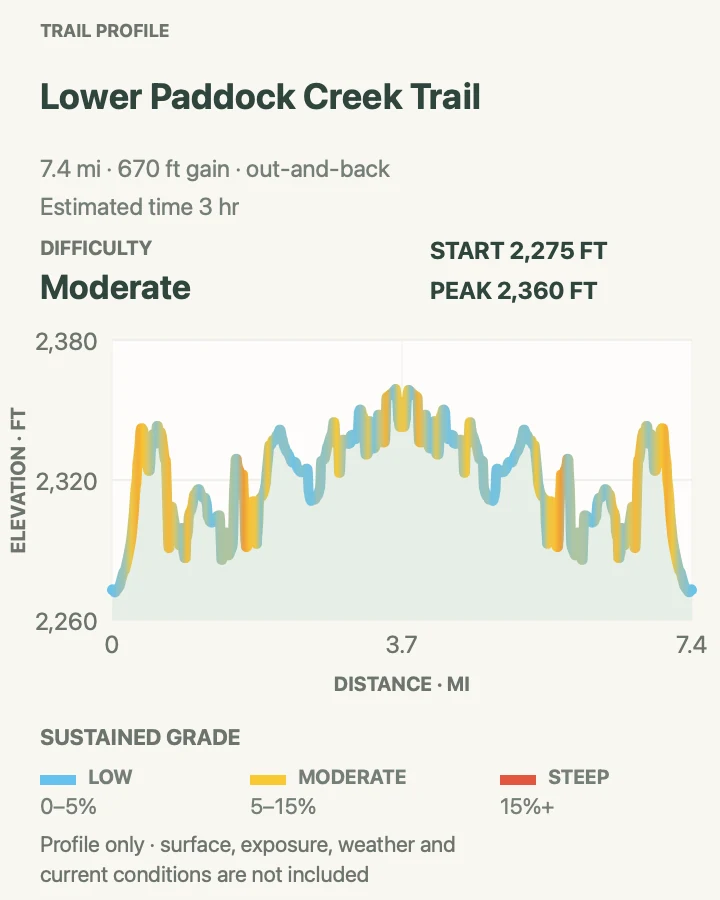
Lower Paddock Creek is one side of the park's 11.4-mile lower backcountry loop. This 7.4-mile out-and-back keeps the route centered on the Paddock drainage and uses the map's endpoint as the turnaround. It is a useful compromise when the full Jones-Talkington circuit is too long.
The valley floor appears gentle, but creek crossings, sticky soil, and route-finding at connectors add time. There is little dependable shade and no approved drinking water. Start with the full supply, watch the weather beyond the buttes, and reverse course before wet clay makes the return slower than expected.
What helps on this route
- Confirm the mapped turnaround at every signed junction instead of following the lower-loop signs by habit.
- Carry gaiters or spare socks in muddy conditions, but abandon the hike if bentonite begins caking underfoot.
Terrain and access: Creek-bottom dirt and clay, shallow crossings, open prairie, connector junctions, and little shade.

Lower Talkington Trail
- Distance
- About 4.7 miles round trip
- Elevation gain
- 440 feet
- Time
- About 2 hours
- Difficulty
- Moderate
- Route type
- Out and back
- Parking
- Use the signed Talkington Trail roadside pullout reached from I-94 Exit 36.
- Best time
- Morning or evening in dry weather, when wildlife is active and heat is lower.
- Pets
- Pets are not permitted on this trail.
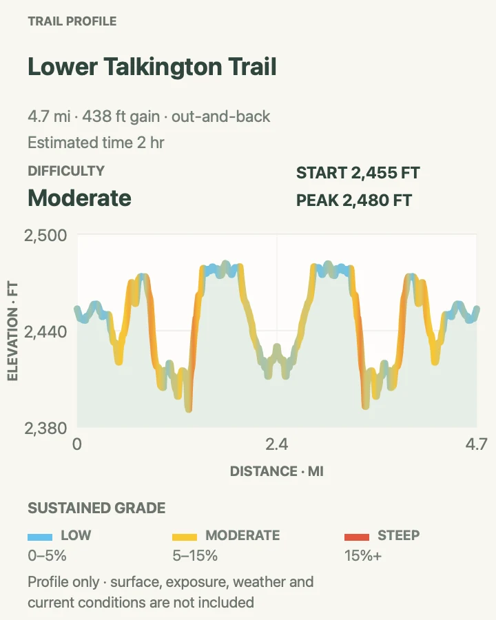
Lower Talkington begins at the roadside pullout on the South Unit's eastern side. It connects with Jones Creek and Lower Paddock to make the official lower loop, but this out-and-back stops at about 4.7 miles. That shape suits hikers who want the valley without a six- to eight-hour circuit.
Feral horses often use the southeastern part of the park around the Talkington trailhead. They still need at least 25 yards, and more if the group shifts toward you. Creek-bottom vegetation can also hide wildlife and make the trail faint, so pause before blind bends and confirm the return junction.
What helps on this route
- Set the out-and-back turnaround in advance; lower-loop signs otherwise invite an unplanned extension.
- Scan the flats from the pullout for horses or bison before leaving the vehicle.
Terrain and access: Open valley trail with creek crossings, grass, clay, faint sections, and links to longer loops.

Upper Talkington Trail
- Distance
- About 7.5 miles round trip
- Elevation gain
- 590 feet
- Time
- About 3 hours
- Difficulty
- Moderate
- Route type
- Out and back
- Parking
- Use the signed Talkington Trail roadside pullout reached from I-94 Exit 36.
- Best time
- A cool, dry morning with a clear forecast across the exposed eastern plateau.
- Pets
- Pets are not permitted on this trail.
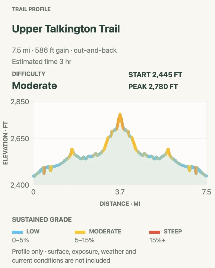
Upper Talkington leaves the same eastern access area but commits to a longer line across higher country. The 7.5-mile out-and-back is one component of the Upper Paddock-Talkington system, which NPS usually describes as a 15.4-mile loop or 19.4 miles when approached from Painted Canyon.
Using it as an out-and-back avoids the full loop while preserving a clear route home. The ground is exposed to sun, wind, and fast-moving storms, and intervening buttes can hide the trailhead from view. Track junctions carefully and keep a hard turnaround based on water and weather rather than pace alone.
What helps on this route
- Record the point where Upper and Lower Talkington divide so the return does not drift onto the lower loop.
- Turn back at the first audible thunder; the upper ground offers no reliable lightning shelter.
Terrain and access: Exposed prairie and badlands trail with rolling grades, clay, network junctions, and very little shade.

Upper Paddock Creek Trail
- Distance
- About 17.1 miles round trip
- Elevation gain
- 1,630 feet
- Time
- About 7 hours
- Difficulty
- Moderate, with a strenuous distance commitment
- Route type
- Out and back
- Parking
- Use the signed Upper Paddock Creek trailhead in the South Unit and verify road access before the early start.
- Best time
- A long, cool, dry day with stable weather and an early departure.
- Pets
- Pets are not permitted on this trail.
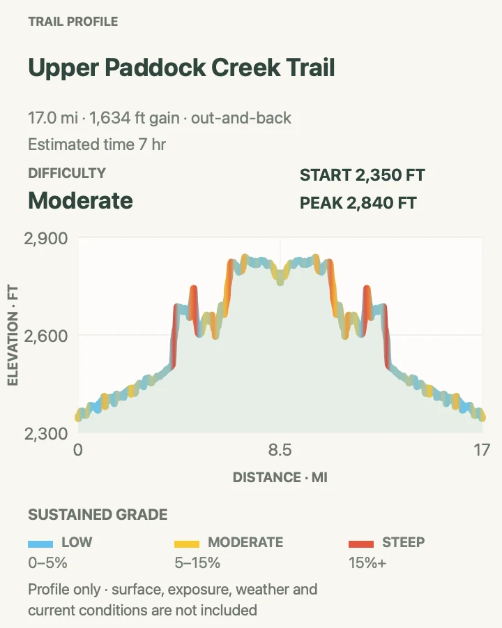
Upper Paddock Creek is the longest South Unit entry in this guide. The mapped out-and-back measures 17.1 miles, threading a corridor that also feeds the Upper Paddock-Talkington loop and the Painted Canyon connection. Moderate grades do not soften the consequence of that distance, exposure, and limited exit options.
Carry the day's water rather than depending on a creek or spring, and plan for seven hours or more if mud, wildlife, or navigation slows the return.
The last miles deserve the same daylight margin as the first. An overnight plan requires a free permit obtained in Medora, not at Painted Canyon.
What helps on this route
- Set a time-based turnaround even if the mapped endpoint is still ahead; the same distance remains for the return.
- Leave an itinerary and trailhead description with someone who is not on the hike.
- Carry the full day's water; no creek or spring on the route is an approved drinking source.
Terrain and access: Long, exposed creek corridor and prairie trail with clay, multiple junctions, limited shade, and few quick exits.

Little Mo Trail
- Distance
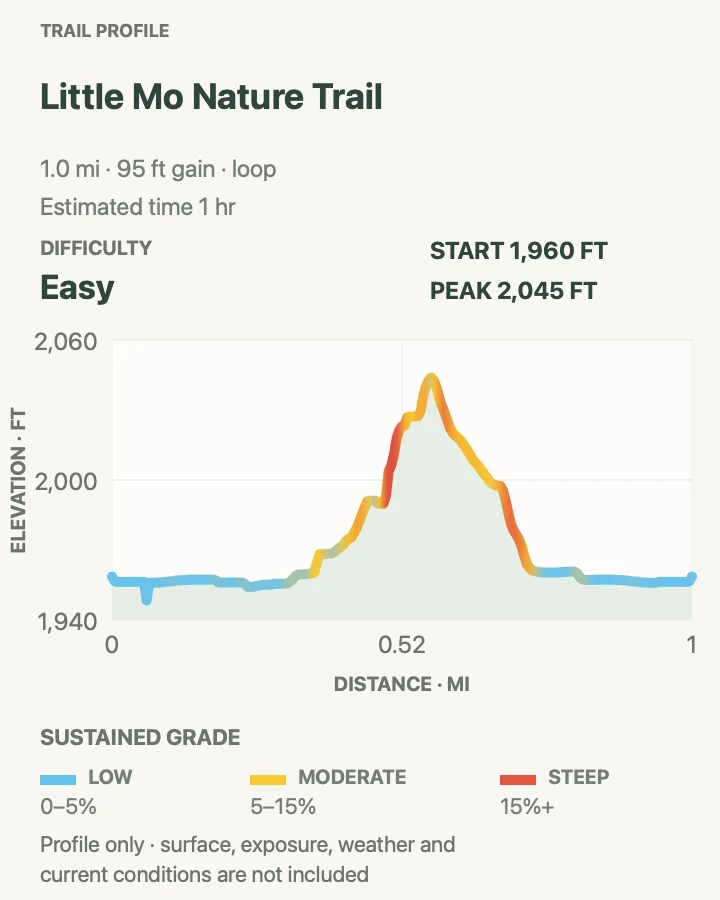
- About 1 mile around the loop
- Elevation gain
- 95 feet
- Time
- 30 minutes to 1 hour
- Difficulty
- Easy
- Route type
- Loop
- Parking
- Use the designated Little Mo trail access at Juniper Campground in the North Unit.
- Best time
- Morning, when the river bottom is cool and campground traffic is light.
- Pets
- Pets are not permitted on this trail.
Little Mo explores cottonwood and river-bottom habitat beside Juniper Campground. NPS offers a 0.7-mile paved inner loop and a longer unpaved outer loop; the mapped line measures about one mile and is best understood as the longer option rather than a fully paved circuit.
The setting feels developed at the start, but bison regularly enter the campground and river corridor. Look across the grass before leaving the parking area, carry the interpretive brochure if available, and use the paved inner loop when stairs, dirt, or recent rain make the outer route unsuitable.
What helps on this route
- Choose the inner loop at the signed split if you need pavement for the complete walk.
- Check picnic and campground lawns for bison before walking from the vehicle to the trailhead.
Terrain and access: Paved inner loop and unpaved outer loop with slight grades, stairs, river-bottom soil, and cottonwood shade.

Prairie Dog Town via Buckhorn Trail
- Distance
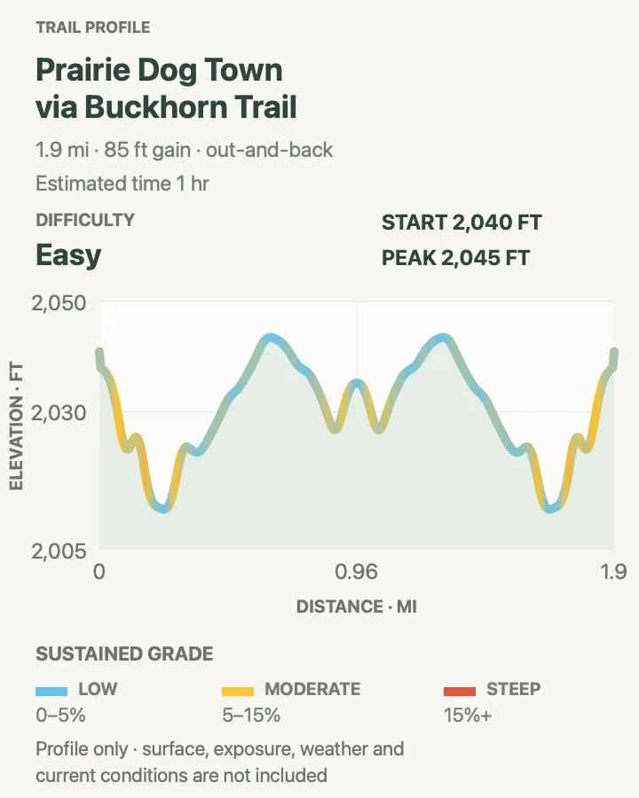
- About 1.9 miles round trip
- Elevation gain
- 85 feet
- Time
- About 1 hour
- Difficulty
- Easy
- Route type
- Out and back
- Parking
- Use the Caprock Coulee trailhead pullout on North Unit Scenic Road.
- Best time
- Morning or late afternoon, when prairie dogs are active and the open trail is cooler.
- Pets
- Pets are not permitted on this trail.
No prairie dog town is visible from the North Unit road. This Buckhorn segment leaves the Caprock Coulee trailhead and reaches a colony on open prairie in a 1.9-mile round trip, slightly longer than the park's rounded planning distance. The animals are the destination, but their burrows require attention too. Stay on the signed route, keep hands away from holes, and scan for rattlesnakes. Bison also graze around prairie dog towns and can turn a short outing into a patient wait.
What helps on this route
- Bring binoculars and stop outside the colony instead of walking toward individual animals.
- Keep headphones off so prairie-dog alarm calls and approaching large wildlife remain audible.
Terrain and access: Open prairie path with burrows, low rolling grades, cactus, wildlife, and almost no shade.

Caprock Coulee Loop
- Distance
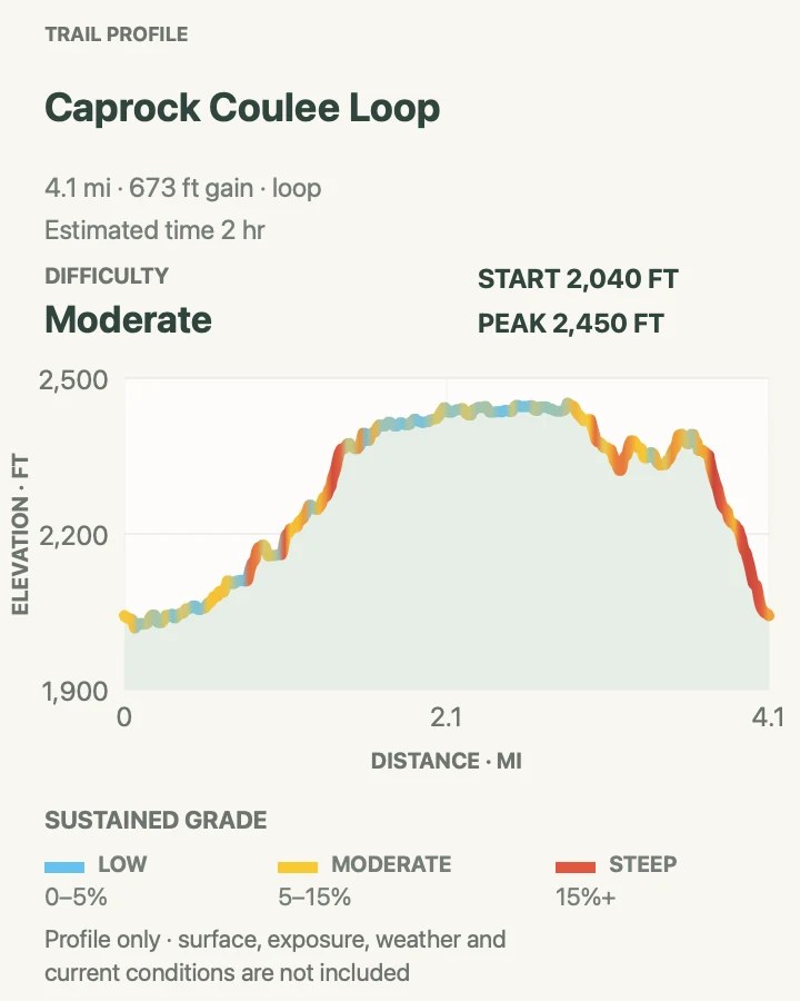
- About 4.2 miles around the loop
- Elevation gain
- 670 feet
- Time
- 2 to 3 hours
- Difficulty
- Moderate
- Route type
- Loop
- Parking
- Use the Caprock Coulee trailhead pullout between mile markers 6 and 7 on North Unit Scenic Road.
- Best time
- A dry morning for cool coulees and clear light from the grassy ridge.
- Pets
- Pets are not permitted on this trail.
Caprock Coulee begins with the interpretive nature-trail section, enters wooded and dry coulees, then climbs onto a grassy butte and ridgeline. The descent closes a 4.2-mile loop through wooded and dry coulees, grassy buttes, and ridgeline prairie without requiring a river ford.
Take the signed left fork for the nature-trail sequence; the right fork leads toward Buckhorn. Brief steep sections, bentonite, and a more strenuous ridge climb arrive after the easy opening. Carry the park map and avoid the loop when wet clay makes the first slopes unreliable.
What helps on this route
- Photograph the fork signs near the nature-trail end so the return connections are familiar.
- Use the 1.9-mile prairie-dog route as a separate short outing instead of adding it casually to this loop.
Terrain and access: Narrow dirt path, dry washes, wooded coulees, brief steep grades, open ridge, and clay that becomes slick when wet.

Sperati Point via Achenbach Trail
- Distance
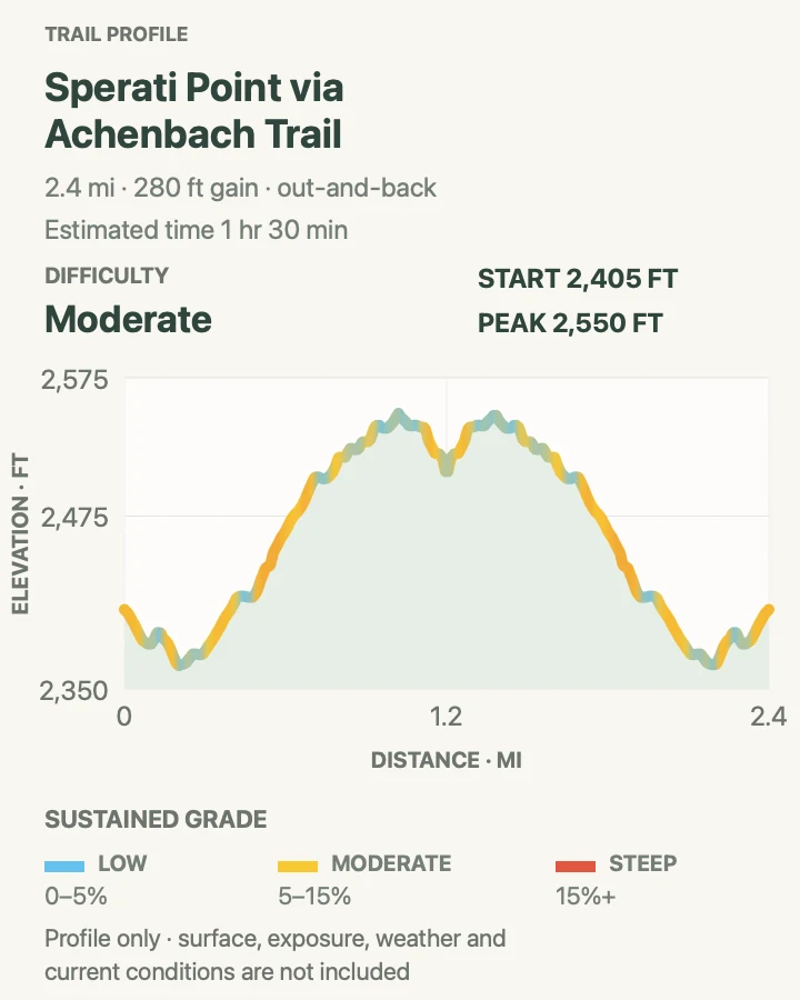
- About 2.4 miles round trip
- Elevation gain
- 280 feet
- Time
- About 1 hour 30 minutes
- Difficulty
- Moderate
- Route type
- Out and back
- Parking
- Start at Oxbow Overlook at the end of North Unit Scenic Road.
- Best time
- Morning or evening for lower heat and long views over the Little Missouri River.
- Pets
- Pets are not permitted on this trail.
Sperati Point follows the Achenbach corridor from Oxbow Overlook across gently rolling prairie to a broad Little Missouri viewpoint. NPS commonly describes a shorter 1.5-mile visit; the complete mapped out-and-back used here measures 2.4 miles. Follow the map and trail signs rather than aiming cross-country at the view.
This approach shares part of the full Achenbach circuit, but the trip decision is entirely different. Sperati needs an hour or two and no river crossing. Achenbach needs an all-day wilderness plan, steep climbs, and two crossings. The short route stays because the point is a worthwhile destination on its own.
What helps on this route
- Use Oxbow Overlook as the firm start and return point; do not continue onto Achenbach without the all-day plan.
- Keep distance from the bluff edge, where prairie turf can conceal an eroded lip.
Terrain and access: Rolling prairie on a defined backcountry trail, with open wind, little shade, and a bluff-top destination.

Buckhorn Trail
- Distance
- About 11.1 miles around the loop
- Elevation gain
- 1,150 feet
- Time
- Allow 6 to 8 hours
- Difficulty
- Moderate to strenuous
- Route type
- Loop
- Parking
- Use the signed Buckhorn access near Juniper Campground in the North Unit; confirm the intended trailhead on the park map.
- Best time
- A cool, dry day with an early start and a stable forecast.
- Pets
- Pets are not permitted on this trail.
Buckhorn makes a broad North Unit loop through prairie dog colonies, sagebrush terraces, wooded slopes, deep canyons, and high prairie. The mapped line measures 11.1 miles, close to the NPS 11.4-mile figure. Variety, rather than one summit, is the reason to give it most of a day.
Several signed access points touch the trail, so confirm where the vehicle sits before starting.
NPS budgets six to eight hours, longer than a simple pace calculation, because wildlife, mud, heat, and route checks matter. Carry every liter needed and leave enough daylight for a delayed final section.
What helps on this route
- Photograph the trailhead name and save its coordinates; another Buckhorn access can look like the finish.
- Pause before entering prairie dog towns and wooded bends where bison may be hidden from view.
- Carry all needed water and keep a daylight margin for wildlife or mud delays.
Terrain and access: Long loop across sagebrush flats, prairie dog towns, wooded hillsides, clay canyons, and exposed high prairie.

Achenbach
- Distance
- About 18.1 miles around the loop
- Elevation gain
- 2,650 feet
- Time
- Allow 10 to 12 hours
- Difficulty
- Hard
- Route type
- Loop
- Parking
- Begin at the signed South Achenbach access near Juniper Campground after confirming river depth and route status with North Unit rangers.
- Best time
- A long, cool, dry day with a dawn start and confirmed low river conditions.
- Pets
- Pets are not permitted on this trail.
Achenbach is the guide's largest commitment: an 18.1-mile mapped loop with steep climbs, descents into the Little Missouri valley, and two river crossings. The route combines South and North Achenbach segments and shares the terminal approach toward Oxbow with the shorter Sperati Point walk. NPS treats the complete circuit as a 10- to 12-hour wilderness day.
Both crossings need current information from the North Unit Visitor Center. A ford that works at dawn must still work on the return side of the loop, and rain upstream can alter the river.
Carry a detailed map, a headlamp, all drinking water, and an itinerary shared at home. If any one of those pieces is missing, choose Buckhorn or Sperati instead.
What helps on this route
- Ask rangers for the depth and condition of both crossings, not a general statement that the river is low.
- Start at daybreak and carry a headlamp even when the forecast and pace suggest a daylight finish.
- Carry a detailed map and all drinking water; the full loop has no quick road exit.
- Leave the route and expected return time with someone at home before entering the wilderness.
Terrain and access: Remote wilderness loop with two Little Missouri River fords, steep butte climbs, exposed prairie, clay, and long distances between road access.

Elkhorn Ranch Unit Trail
- Distance
- About 1.4 miles round trip
- Elevation gain
- 10 feet
- Time
- About 1 hour
- Difficulty
- Easy
- Route type
- Out and back
- Parking
- Use the designated Elkhorn Ranch Unit parking area after following the current NPS route on remote gravel roads.
- Best time
- A dry morning or afternoon when the final roads are firm and daylight remains for the drive out.
- Pets
- Pets are not permitted on this trail.
Elkhorn Ranch is the only hike here in the park's third unit. A mowed path runs about 0.7 mile from the parking area to the cabin site, making this a 1.4-mile round trip. Foundation stones and exhibits mark the place where Roosevelt established his home ranch; there are no surviving cabin walls, visitor center, or other developed facilities.
The drive is the harder part of the visit. NPS routes vehicles over long stretches of unpaved road, and the final three miles may require high clearance or four-wheel drive after rain or in winter. Cell service is absent along much of the approach.
Ask about road conditions, download the official directions, and turn around before a soft road becomes a recovery problem.
What helps on this route
- Save the NPS turn-by-turn directions offline; map apps can favor an unsuitable river crossing or ranch road.
- Carry food, water, and a vehicle emergency kit even though the walk itself is only 1.4 miles.
- Turn around if the final road is soft enough to threaten the drive back.
Terrain and access: Mowed path through open ranch country and cottonwoods; hiking is easy, but access uses remote unpaved roads with no cell service.

Official planning sources
Trail access and safety details were checked against these National Park Service pages. The maps and profiles follow the corresponding route geometry.
- NPS: Theodore Roosevelt hiking and trail information
- NPS: Current conditions and live alerts
- NPS: South Unit access and Ridgeline closure
- NPS: South Unit Scenic Loop Road reopening
- NPS: North Unit planning
- NPS: Visitor centers, driving distance, and unit time zones
- NPS: Elkhorn Ranch Unit access
- NPS: South Unit nature trails
- NPS: South Unit short walks
- NPS: South Unit backcountry trails
- NPS: North Unit backcountry trails
- NPS: Trail, weather, water, and wildlife safety
- NPS: Backcountry permits and regulations
- NPS: Pet restrictions and current park regulations
- NPS: Painted Canyon Trail
- NPS: Petrified Forest trail and approved legal access route
- NPS: Talkington Trail roadside pullout
Map data © OpenStreetMap contributors. Trail geometry and planning details include National Park Service public information.