21 Best Hikes in Redwood National Park
Twenty-one Redwood hikes with terrain, satellite and grade maps, measured elevation profiles, permit details, coastal safety, and live NPS alerts.
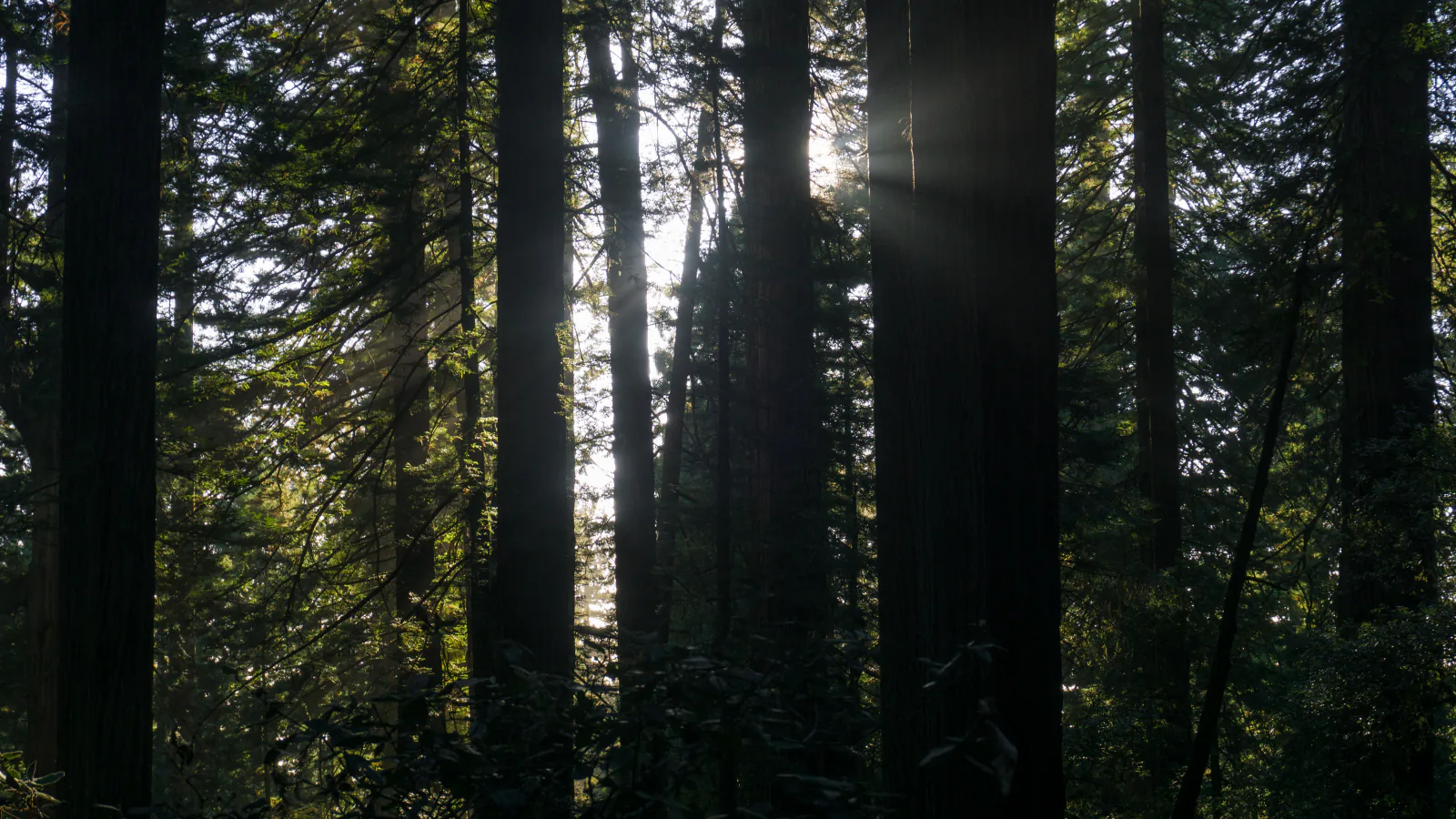
Featured image: Alexey Komarov / Wikimedia Commons, CC BY-SA 4.0. Cropped from the original. Source · CC BY-SA 4.0
Redwood is not one compact grove with a ring road. The jointly managed national and state parks stretch along roughly 50 miles of northern California coast, and the useful hikes are scattered between Bald Hills Road, Prairie Creek, the Klamath coast, Crescent City, and Howland Hill Road. A two-mile forest loop can be a complete morning; the next trailhead may be an hour away.
These twenty-one hikes cover that spread without treating every connector and turnaround as a separate experience. Lady Bird Johnson, Tall Trees, Trillium Falls, Davison, Redwood Creek, and Skunk Cabbage anchor the southern half. Bald Hills routes reach prairie and ranch country. The Klamath coast contributes beach, bluff, history, and ridge walks. Crescent Beach, Mill Creek, Hiouchi, and Little Bald Hills carry the guide north to the Smith River and Howland Hill Road.
Official trail information and conditions were checked on August 30, 2026. Tall Trees is open with its year-round reservation requirement. Seasonal footbridges on Redwood Creek, between Stout Grove and Jedediah Smith Campground, and between Stout Grove and Hiouchi Trail are in place. Dolason Prairie is open for its first 4.5 miles but closed at the failed Emerald Creek bridge, so the mapped 9.1-mile out-and-back turns there rather than continuing as a through-route. A Bald Hills Road paving project beyond the Lady Bird Johnson Grove parking lot can cause 20–30 minute delays in both directions; access to the grove parking lot is not affected. Separately, a section of the multi-use trail along West Branch Road, west of Rock Creek Road, is closed because of a failed bridge crossing. Read the live panel below again before leaving service.
Live park weather
Redwood National Park
Prairie Creek Visitor Center
Loading the latest conditions and alerts…
What changes a hiking day here
Reserve Tall Trees before turning onto the access road
Tall Trees Trailhead requires a free online reservation year-round. The confirmation supplies the locked-gate code. Allow about an hour of driving from the nearest visitor center, including six narrow dirt-road miles; vehicles over 21 feet and all trailers are excluded. The reservation controls parking, not the weather or trail conditions.
Build the day around geography, not a wish list
Lady Bird Johnson, Trillium Falls, and Redwood Creek cluster near Orick, but Little Bald Hills is near the park's northern end. Enderts Beach, Klamath, and the Bald Hills trailheads also use different highway exits and slower side roads. Two well-paired hikes usually make a better day than four rushed trailhead stops.
Treat Redwood Creek as seasonal terrain
The summer footbridges are currently in place, but they are removed for the high-water season and Redwood Creek can become impassable. A line that works in August is not a winter promise. Ask at a visitor center before using the creek to connect Tall Trees, Dolason, or Emerald Ridge.
Keep the Pacific in view
Enderts Beach and coastal sections have sneaker waves, cold water, loose cliffs, and access points that can disappear on a rising tide. Check a tide table, keep watching the ocean, and stay off driftwood in wet sand. If an earthquake is strong or lasts around 20 seconds, leave the beach for high ground without waiting for an official tsunami warning.
Give Roosevelt elk much more than a photo's width
NPS recommends at least 25 yards and more space during calving season in late May and June and the fall rut from late August through October. Elk commonly use Elk Meadow, Bald Hills Road, and the Enderts area. If an animal controls the trail, back away and find another route; do not move into brush to squeeze past.
Expect mud, poison oak, and ticks
Fog and rain keep these forests green and the tread damp. Waterproof footwear helps on longer routes, while long trousers reduce contact with poison oak and ticks. The plant's oil can remain on boots, clothing, and gear, so wash suspected contact rather than carrying it into the car.
Leave pets off every listed trail
Pets are not permitted on national or state park trails. Leashed pets may use designated roads, parking areas, campgrounds, picnic areas, and road-access beaches; Cal Barrel Road and Walker Road are the old-growth walking alternatives. A parking lot being pet-friendly does not make the trail beyond it pet-friendly.
| Trail | Distance | Time | Difficulty | Best for |
|---|---|---|---|---|
| Lady Bird Johnson Grove Trail | About 1.5 miles for the complete mapped loop | 32 min | Easy | A short first walk among old-growth redwoods with an interpretive thread |
| Tall Trees Grove Loop Trail | About 3.7 miles on the mapped route; NPS plans the full outing as roughly 4.5 miles | Allow 2–3 hours on foot, plus the access-road drive | Moderate | A reserved descent into one of the park's most imposing alluvial redwood groves |
| Trillium Falls Trail | About 2.6 miles for the loop shown here | 1 hr 14 min | Moderate | A moderate family-sized redwood loop with a small mossy waterfall |
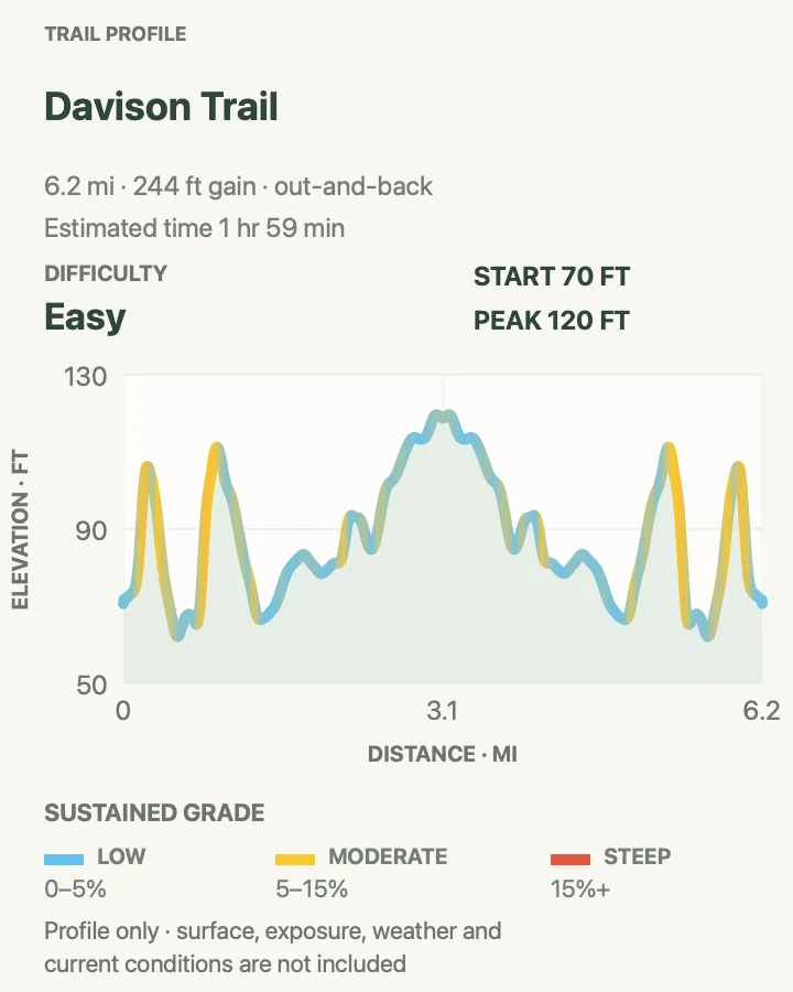
| Davison Trail | About 6.2 miles round trip on the mapped out-and-back | 1 hr 59 min | Easy | An easy, longer forest walk through a recovering former logging corridor |
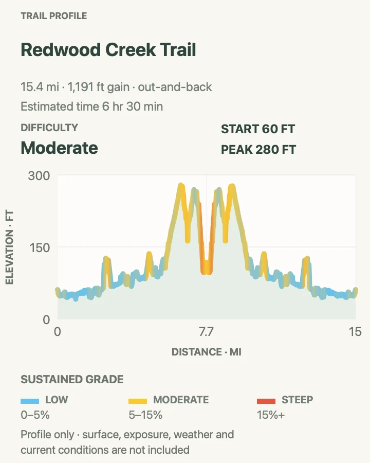
| Redwood Creek Trail | About 15.4 miles round trip on the recorded track | 6 hr 30 min | Moderate | A long, mostly low-gradient creek day with the option to approach Tall Trees from below |
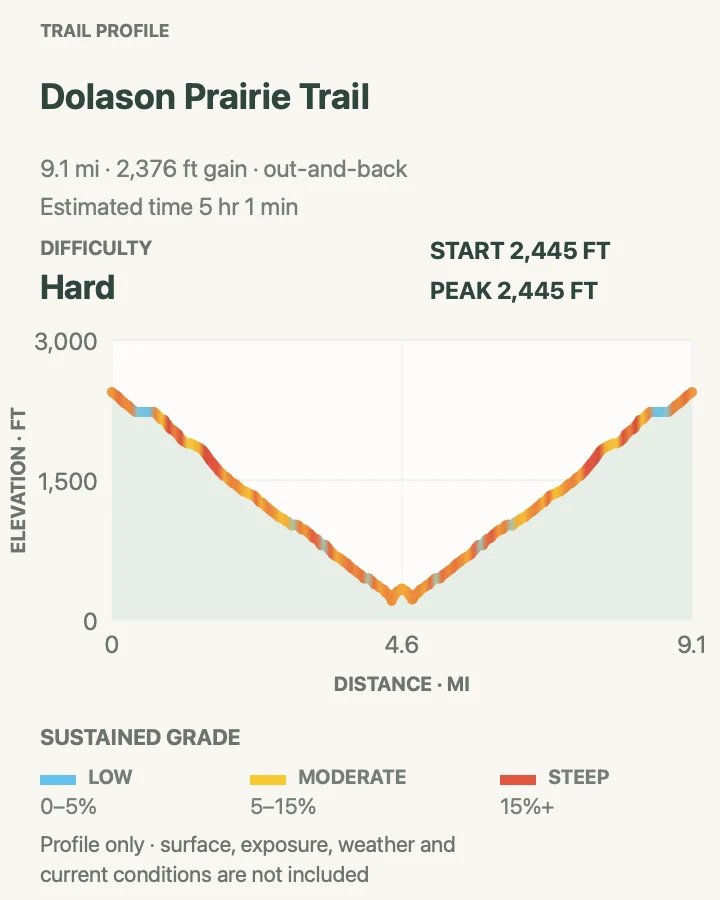
| Dolason Prairie Trail | About 9.1 miles round trip to the current closure area | 5 hr 1 min | Hard | A demanding descent from open Bald Hills prairie into old-growth redwood forest |
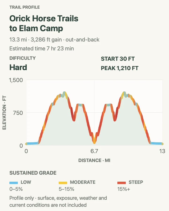
| Orick Horse Trails to Elam Camp | About 13.3 miles round trip to Elam Camp | 7 hr 23 min | Hard | A quieter full-day redwood route with ridge views and an Elam Creek turnaround |
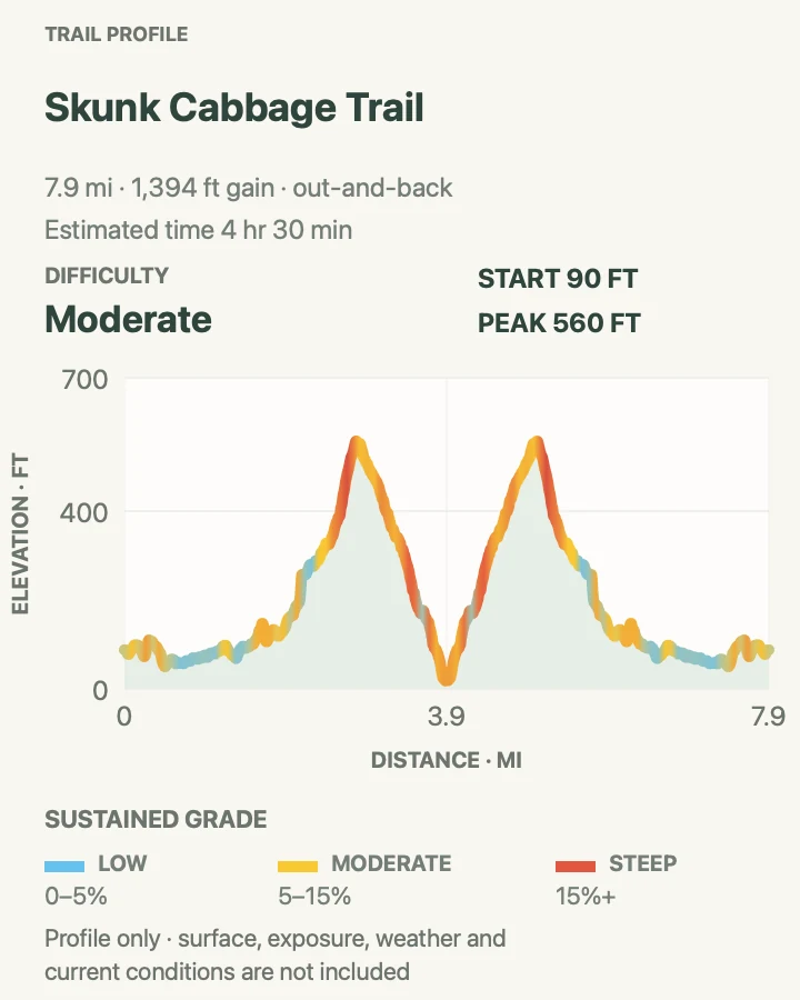
| Skunk Cabbage Trail | About 8 miles round trip to the mapped turnaround | 4 hr 30 min | Moderate | A longer Coastal Trail section that combines creek forest, redwoods, spruce, and open hillsides |
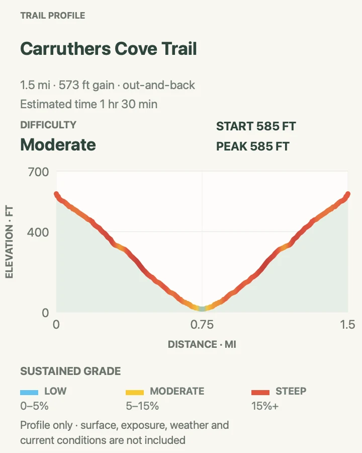
| Carruthers Cove Trail | About 1.5 miles round trip including the complete mapped approach; the signed trail itself is shorter | 1 hr 30 min | Moderate | A short, steep forest descent to a quieter pocket of coast |
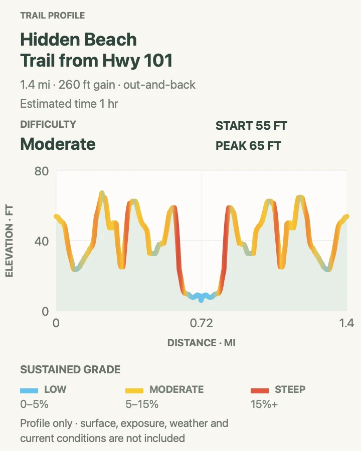
| Hidden Beach Trail from Highway 101 | About 1.5 miles round trip from Highway 101 | 1 hr | Moderate | A direct forest-and-bluff approach to Hidden Beach without repeating the longer Klamath connector |
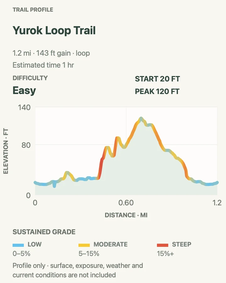
| Yurok Loop Trail | About 1.2 miles for the full loop | 1 hr | Easy | A short coastal loop with False Klamath Cove, sea-stack, and lagoon views |
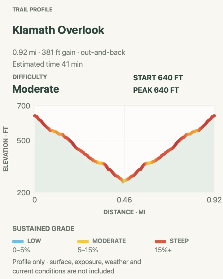
| Klamath River Overlook Trail | About 0.9 mile round trip to the lower overlook | 41 min | Moderate | A steep, compact descent from the main overlook to a lower Pacific viewpoint |
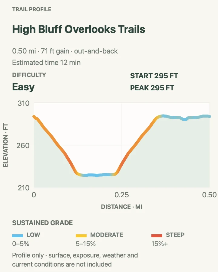
| High Bluff Overlooks Trails | About 0.5 mile round trip across the mapped overlook paths | 12 min | Easy | A very short coastal stop with a lower viewpoint below the parking area |
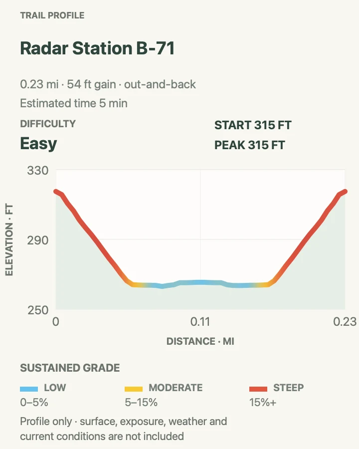
| Radar Station B-71 Trail | About 0.2 mile round trip on the maintained path | 5 min | Easy | A brief walk to a rare surviving World War II early-warning radar station |
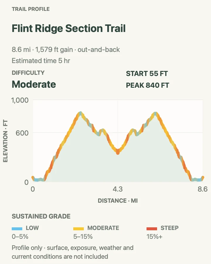
| Flint Ridge Section Trail | About 8.6 miles on the mapped out-and-back route | 5 hr | Moderate | A lower-traffic coastal-forest ridge day with the old radar-station landscape nearby |
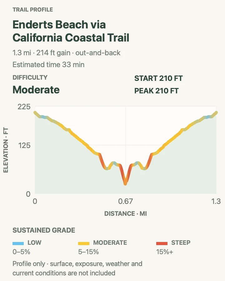
| Enderts Beach via the California Coastal Trail | About 1.3 miles round trip | 33 min | Moderate | A short descent to tidepools and a wild Pacific beach |
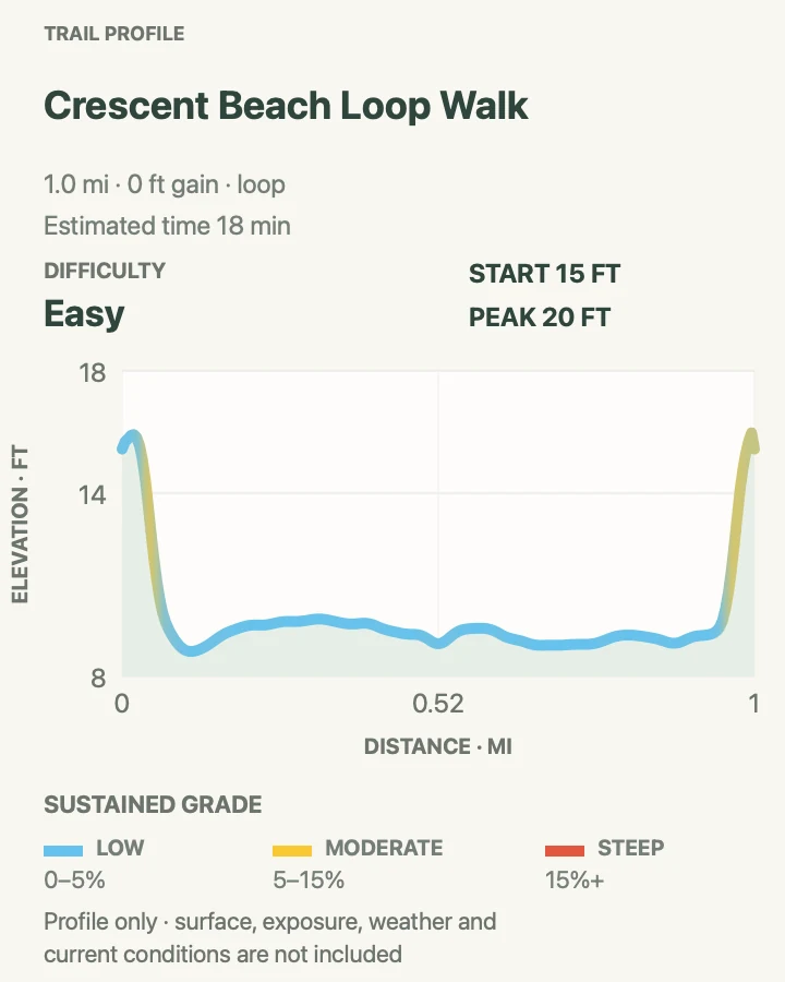
| Crescent Beach Loop Walk | About 1 mile for the beach-and-path loop | 18 min | Easy | An easy family beach circuit with very little climbing |
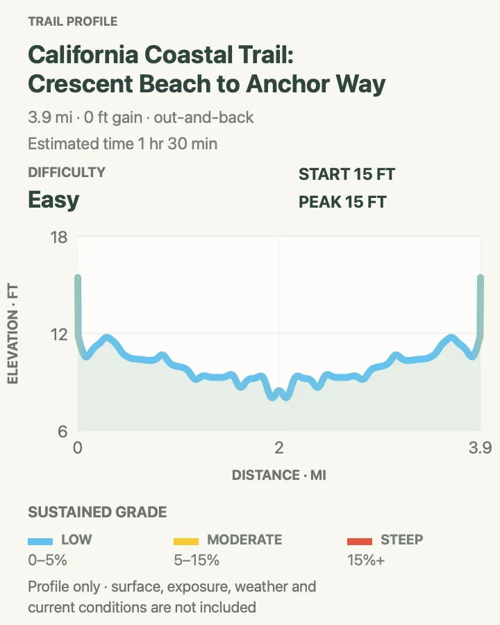
| California Coastal Trail: Crescent Beach to Anchor Way | About 3.9 miles round trip to the selected turnaround | 1 hr 30 min | Easy | A longer, mostly gentle Crescent Beach section with spruce, prairie, and coastal views |
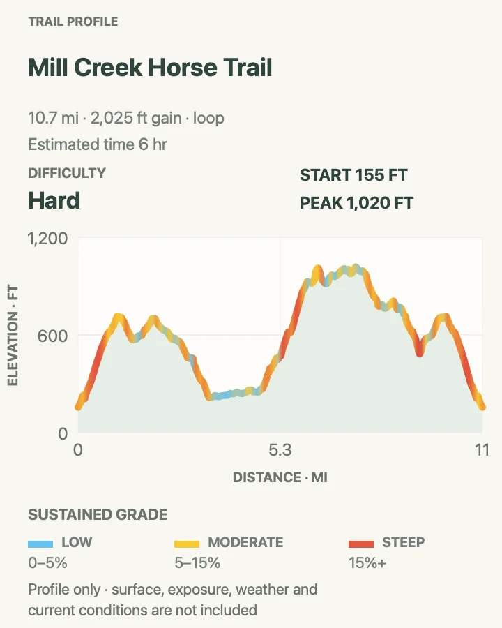
| Mill Creek Horse Trail | About 10.8 miles on the connected loop | 6 hr | Hard | A hard, long loop through recovering forest with ridge views toward Crescent City |
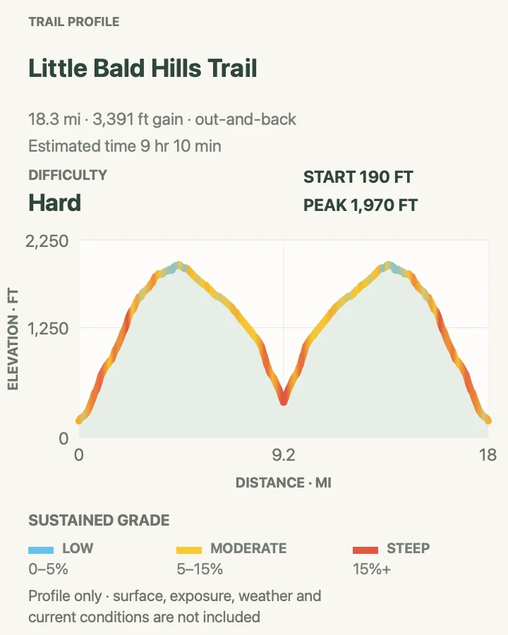
| Little Bald Hills Trail | About 18.3 miles round trip to the mapped turnaround | 9 hr 10 min | Hard | A strenuous all-day traverse from redwood forest to serpentine ridge and open prairie |
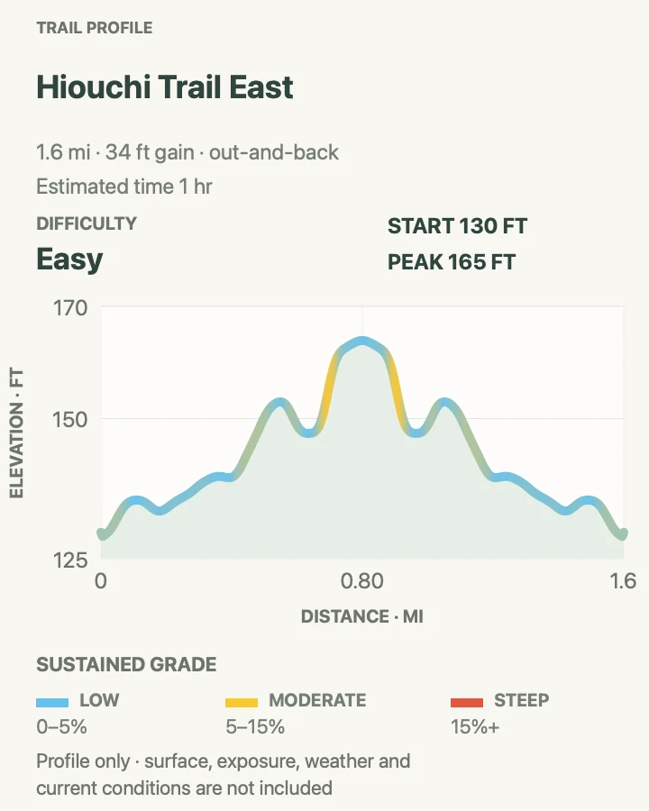
| Hiouchi Trail East | About 1.6 miles round trip on the east-side segment | 1 hr | Easy | A short Smith River walk through riparian forest and old-growth redwoods |
Lady Bird Johnson Grove Trail
- Distance
- About 1.5 miles for the complete mapped loop
- Elevation gain
- 170 feet
- Time
- 32 min
- Difficulty
- Easy
- Route type
- Loop
- Parking
- Use the marked lot about two miles up Bald Hills Road from US 101. RVs and trailers cannot use this trailhead.
- Best time
- A foggy morning for forest atmosphere, or spring for rhododendrons and azaleas.
- Pets
- Pets are not permitted on this trail.
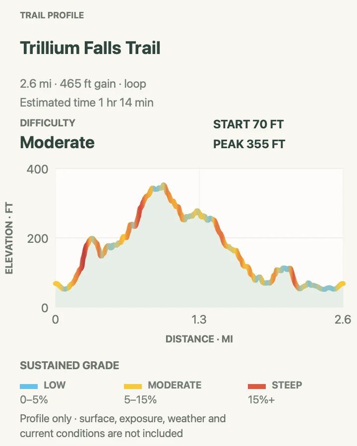
Lady Bird Johnson Grove is the easiest place in this guide to understand the scale of a redwood forest without committing half the day. The loop crosses a footbridge and runs through old-growth redwood, Douglas-fir, and tanoak around the 1969 park dedication site. Numbered posts correspond to a trail brochure, but the path still works as a quiet walk if you skip the booklet.
The official route is commonly rounded to one mile; the mapped line, including its approach and complete loop, measures about 1.5 miles with roughly 170 feet of accumulated gain. It is not fully accessible: some grades are steeper than the opening suggests. Parking is the real constraint, so arrive early and save longer vehicles for Elk Meadow.
What helps on this route
- Take the loop in either direction; there is no inferior half or required ranking order.
- Keep voices low near the bridge, where a surprising amount of highway noise drops away once the forest closes in.
Terrain and access: Mostly gentle forest tread, a footbridge, shallow roots, short non-level grades, and a compact old-growth loop.

Tall Trees Grove Loop Trail
- Distance
- About 3.7 miles on the mapped route; NPS plans the full outing as roughly 4.5 miles
- Elevation gain
- 680 feet
- Time
- Allow 2–3 hours on foot, plus the access-road drive
- Difficulty
- Moderate
- Route type
- Out-and-back approach with a grove loop
- Parking
- A free year-round online reservation and emailed gate code are required. The narrow six-mile dirt access excludes trailers and vehicles over 21 feet.
- Best time
- The earliest practical reservation window for a quiet grove and an unhurried drive back through the gate.
- Pets
- Pets are not permitted on this trail.
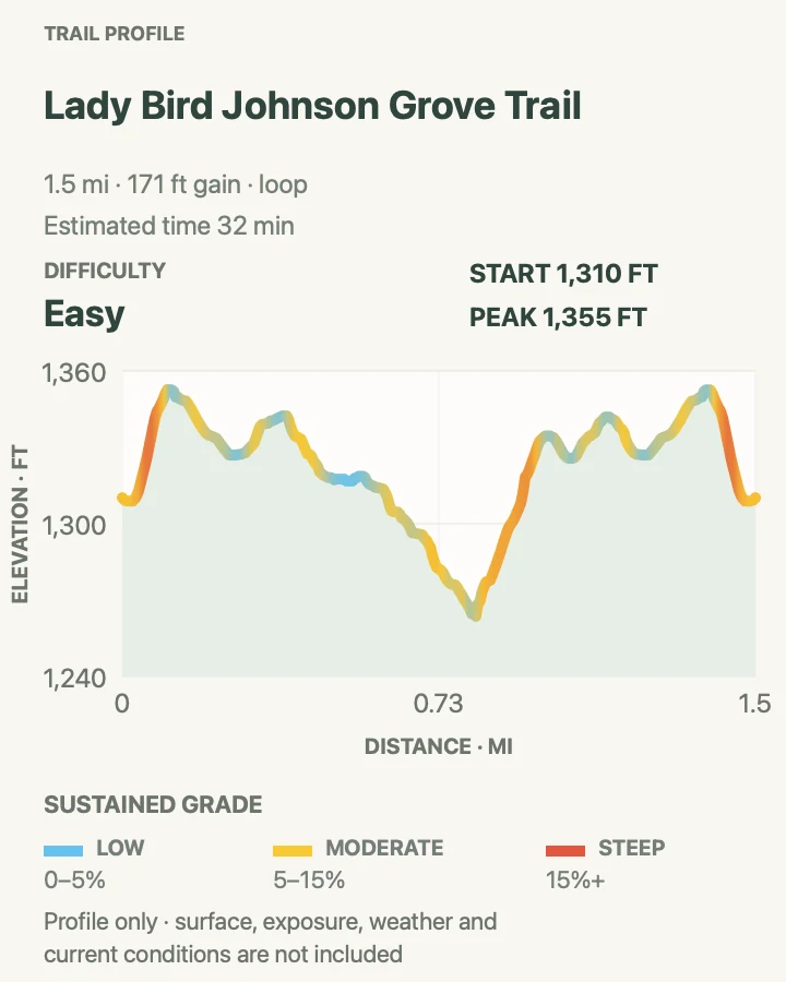
Tall Trees makes you work for a grove that first appears far below the parking area. NPS describes an 800-foot drop in the first 1.5 miles, followed by the low loop among coast redwoods, bigleaf maple, and California laurel. That means the steep part arrives on the return, after the quietest and flattest walking is already behind you.
The mapped track measures 3.7 miles and about 675 feet of accumulated gain, while NPS budgets the complete hike at 4.5 miles and asks visitors to reserve at least four hours for driving and walking. Use the official trip figure for scheduling. The reservation is free, but it is not optional and visitor centers do not issue walk-up parking permits.
What helps on this route
- Save the gate-code email offline before leaving reliable service.
- Do not bring a trailer or hope that an oversized RV can turn around at the locked gate.
Terrain and access: Steep forest approach, switchbacks, a flatter alluvial-grove loop, soft duff, roots, and a sustained climb back to the car.

Trillium Falls Trail
- Distance
- About 2.6 miles for the loop shown here
- Elevation gain
- 460 feet
- Time
- 1 hr 14 min
- Difficulty
- Moderate
- Route type
- Loop
- Parking
- Begin at Elk Meadow Day Use Area, half a mile along Davison Road from US 101. The lot can accommodate RVs and trailers.
- Best time
- Spring for trillium, or early morning before the Elk Meadow parking area becomes busy.
- Pets
- Pets are not permitted on this trail.
Trillium Falls is a better forest hike than its ten-foot cascade might imply. The loop climbs from Elk Meadow into a mixed canopy of coast redwood, western hemlock, Sitka spruce, and Douglas-fir, then threads past the falls beneath bigleaf maple. The waterfall is a punctuation mark, not the whole sentence.
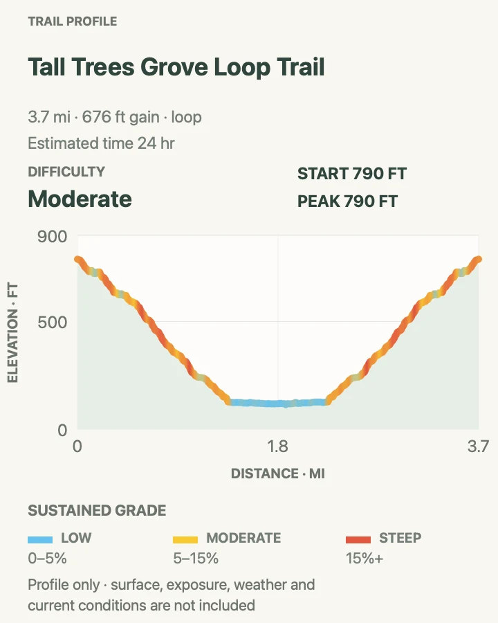
This loop runs 2.6 miles with about 465 feet of gain. Several brief grades are steeper than a casual waterfall walk, and wet roots can slow the descent. Elk often graze around the day-use area; scan the meadow before leaving the car and give any herd a much wider berth during calving season or the rut.
What helps on this route
- Walk the full loop instead of turning around at the falls; the quieter forest beyond is part of the appeal.
- Keep the camera packed until you have checked both sides of Elk Meadow for elk.
Terrain and access: Forest loop with roots, damp duff, a creek crossing, several short steep grades, and a compact mossy cascade.

Davison Trail
- Distance
- About 6.2 miles round trip on the mapped out-and-back
- Elevation gain
- 240 feet
- Time
- 1 hr 59 min
- Difficulty
- Easy
- Route type
- Out and back
- Parking
- Begin at Elk Meadow Day Use Area, where the developed lot can accommodate RVs and trailers.
- Best time
- Morning, when the Elk Meadow end is quieter and wildlife is easier to spot from a safe distance.
- Pets
- Pets are not permitted on this trail.
Davison follows a former logging road from Elk Meadow through wetlands, streamside alder, and stands of redwood. It is a restoration walk as much as a forest walk: the park bought the property in 1996, removed or reshaped damaging road infrastructure, and has been letting water and vegetation reclaim the corridor. Salmon, herons, and songbirds use the recovering habitat.
NPS describes the signed Davison Trail as three miles; the mapped out-and-back measures about 6.2 miles with gentle grades. Bikes share the route, unlike nearby Trillium Falls. Use the map at Elk Meadow to stay on Davison at the Trillium and Streelow connections, and watch the meadow for Roosevelt elk before stepping away from the parking area.
What helps on this route
- Keep right on blind bends and listen for bicycles on the old road grade.
- Pair it with Trillium Falls only if you want two different views of the restoration landscape; the routes do not duplicate one another.
Terrain and access: Broad former road grade, gentle forest and wetland walking, stream crossings, red alder, second-growth redwood, and a few non-level sections.

Redwood Creek Trail
- Distance
- About 15.4 miles round trip on the recorded track
- Elevation gain
- 1,190 feet
- Time
- 6 hr 30 min
- Difficulty
- Moderate
- Route type
- Out and back
- Parking
- Use the signed Redwood Creek Trailhead just east of US 101 on Bald Hills Road; this trailhead has room for RVs and trailers.
- Best time
- Summer or early fall after NPS confirms that seasonal footbridges are in place and creek levels are safe.
- Pets
- Pets are not permitted on this trail.
Redwood Creek trades the steep walls of a grove trail for a long walk along the water. The valley holds coast redwoods, bigleaf maples, gravel bars, and the visible history of a watershed still recovering from old logging roads and floods. The official route reaches Tall Trees in roughly eight miles; the out-and-back shown here is 15.4 miles with about 1,200 feet of accumulated gain.
Low gradient does not mean low consequence. Creek crossings change with the season, winter water can be dangerous, and the footbridges are removed outside their summer window. They were in place when this guide was checked, but that status can change before your hike. Do not use a downloaded track as permission to cross fast water.
What helps on this route
- Ask a ranger about bridge and gravel-bar conditions before attempting the full route.
- Carry treated water capacity and a turnaround time; the return is long even though the profile looks gentle.
Terrain and access: Long creek-valley trail, gravel bars, seasonal crossings, damp forest, mostly modest grades, and limited bailout options.

Dolason Prairie Trail
- Distance
- About 9.1 miles round trip to the current closure area
- Elevation gain
- 2,380 feet
- Time
- 5 hr 1 min
- Difficulty
- Hard
- Route type
- Out and back
- Parking
- Use the marked Bald Hills Road trailhead about 11 miles from US 101. Confirm road conditions and park fully clear of the narrow roadway.
- Best time
- A clear spring morning for prairie flowers and long views, or a cool fall day before heavy rain.
- Pets
- Pets are not permitted on this trail.
Dolason begins high in grass and oak woodland, then gives away most of that elevation on its descent toward Emerald Creek. The transition is the reason to hike it: ranch-country prairie, red-tailed hawks, views toward logged and recovering slopes, and finally the deep redwood gorge. The climb back to Bald Hills Road is the bill that arrives late.
This out-and-back measures 9.1 miles and roughly 2,375 feet of accumulated gain. Current NPS conditions open only the first 4.5 miles and close the trail at the failed Emerald Creek bridge. Treat that barrier as the turnaround and do not attempt a creek or bridge bypass. A through-route to Redwood Creek or Tall Trees is not available from this direction while the closure remains.
What helps on this route
- Save most of your water and patience for the exposed climb back to Bald Hills Road.
- Check the live conditions panel on the morning of the hike; bridge repairs can change the useful distance.
Terrain and access: Exposed prairie, oak woodland, long forest descent, steep switchbacks, about 2,375 feet of gain, and a closed bridge at the current turnaround.

Orick Horse Trails to Elam Camp
- Distance
- About 13.3 miles round trip to Elam Camp
- Elevation gain
- 3,290 feet
- Time
- 7 hr 23 min
- Difficulty
- Hard
- Route type
- Out and back
- Parking
- Begin at the Orick Rodeo Grounds and follow the signed horse-trail system. Leave gates and horse facilities exactly as posted.
- Best time
- A dry, cool day with enough daylight for slow trail finding at the junctions.
- Pets
- Pets are not permitted on this trail.
The Orick horse-trail network gets far less day-hiker attention than the nearby grove loops. From the rodeo grounds, this route climbs through second-growth and old-growth forest to Elam Camp, with occasional openings over Orick Valley and the coast. Hoof traffic and a web of camp connectors make this a navigation walk as much as an endurance one.
The out-and-back runs about 13.3 miles and gains roughly 3,285 feet. Elam is open, but a separate damaged bridge north of 44 Camp makes casual extensions toward the Tall Trees drainage unwise. If this is a day hike, turn at Elam; an overnight stay requires a backcountry permit and current camp rules.
What helps on this route
- Yield to horses by stepping to the downhill side only when the rider directs a safe pass.
- Download the park's backcountry map; trail names and camp connectors matter more here than on a single signed loop.
Terrain and access: Horse trail, long forest climbs, ridge traverses, switchbacks, muddy sections, multiple junctions, and more than 3,000 feet of accumulated gain.

Skunk Cabbage Trail
- Distance
- About 8 miles round trip to the mapped turnaround
- Elevation gain
- 1,390 feet
- Time
- 4 hr 30 min
- Difficulty
- Moderate
- Route type
- Out and back
- Parking
- Use the signed Coastal Trail access on US 101 near mile marker 122.69, or begin from the north near Davison Road if current access allows.
- Best time
- Spring for hillside flowers, or a cool dry day when the creek-side tread is less slick.
- Pets
- Pets are not permitted on this trail.
Skunk Cabbage is a forest-and-creek section of the Coastal Trail, not a beach walk with occasional trees. The route moves from wind-shaped shrubs into a drainage lined by ferns and bigleaf maple, then passes redwoods, spruce, and western hemlock. Open grassy slopes interrupt the canopy and make the change in habitat easy to read.
NPS lists the complete point-to-point section at 5.25 miles. The mapped line is an eight-mile out-and-back using part of that corridor, so its turnaround is not the opposite official trailhead. Moderate grades and switchbacks add up over the longer return. Save the official section map offline and confirm which end is accessible before setting off.
What helps on this route
- Decide on the turnaround before leaving the signed trailhead; this out-and-back and the official point-to-point section are different outings.
- Expect damp vegetation and slick roots even when the highway shoulder is dry.
Terrain and access: Creek drainage, ferns, bigleaf maple, coastal spruce and redwood forest, grassy slopes, moderate switchbacks, and damp tread.

Carruthers Cove Trail
- Distance
- About 1.5 miles round trip including the complete mapped approach; the signed trail itself is shorter
- Elevation gain
- 570 feet
- Time
- 1 hr 30 min
- Difficulty
- Moderate
- Route type
- Out and back
- Parking
- Use the small marked pullout on Coastal Drive about one mile from Newton B. Drury Scenic Parkway. RV and trailer space is very limited.
- Best time
- Near a safely low tide, with a dry forecast for the steep return from the cove.
- Pets
- Pets are not permitted on this trail.
Carruthers Cove follows an old skid road through alder and berry thickets to the beach. It is short, but the setting differs from Enderts and Hidden Beach: the Coastal Drive approach, the steep enclosed descent, and the small cove make it a compact stop between Prairie Creek and Klamath rather than a Crescent City beach outing. Elk and coastal birds sometimes use the open ground.
NPS lists 0.8 mile for the trail, while the complete out-and-back shown here is about 1.5 miles once the approach is counted. Some grades are steep and the beach connection should be treated as tide-dependent. Parking, rather than distance, can decide whether the walk is practical on a busy day.
What helps on this route
- Do not park in the travel lane or block Coastal Drive if the small pullout is full.
- Check the tide before descending and leave the cove while the route back remains dry and obvious.
Terrain and access: Old skid road, alder and berry thickets, steep grades, beach access, loose coastal tread, and a short climb back to the road.



Yurok Loop Trail
- Distance
- About 1.2 miles for the full loop
- Elevation gain
- 140 feet
- Time
- 1 hr
- Difficulty
- Easy
- Route type
- Loop
- Parking
- Use the north side of Lagoon Creek Picnic Area; the developed lot has room for RVs and trailers.
- Best time
- A clear morning for seabirds or late afternoon when the bluff is out of direct sun.
- Pets
- Pets are not permitted on this trail.
Yurok Loop is short enough to add between longer forest hikes, yet its vegetation and exposure make it feel like a different park. The trail rises through coastal scrub and Sitka spruce to bluff views over False Klamath Cove, then returns beside Lagoon Creek. Cormorants, pelicans, guillemots, and murres use the sea stacks offshore.
The loop is 1.2 miles with about 145 feet of accumulated gain. Grades are mild, but wet roots and bluff edges require attention. Fog can erase the distant view and improve the close one; the berries, spruce, and creek do not depend on a postcard horizon.
What helps on this route
- Bring binoculars instead of walking toward the bluff edge for a closer seabird view.
- Pair this with Klamath Overlook, not with another nearly identical coastal connector.
Terrain and access: Coastal scrub, spruce forest, modest bluff climbing, lagoon edge, roots, and exposed ocean viewpoints.

Klamath River Overlook Trail
- Distance
- About 0.9 mile round trip to the lower overlook
- Elevation gain
- 380 feet
- Time
- 41 min
- Difficulty
- Moderate
- Route type
- Out and back
- Parking
- Drive Requa Road to the Klamath River Overlook. The approach and parking are not suitable for larger RVs or trailers.
- Best time
- Spring or fall for migrating gray whales, or a clear evening for sunset over the river mouth.
- Pets
- Pets may use the developed overlook on leash but are not permitted on the trail.
The parking area already has a broad view over the Klamath River mouth, so the trail has to offer something different. It drops toward a lower ocean overlook, trading the windshield panorama for forest edges, marine sound, and a closer angle on the surf. Seals often rest on the sandspit, and gray whales pass in spring and fall.
The out-and-back is only 0.9 mile, but it gains about 380 feet on the climb back and contains sustained steep pitches. Save enough time and traction for the return. The river mouth remains culturally significant to the Yurok people; stay on the trail and treat the interpretive material as part of the visit, not roadside decoration.
What helps on this route
- Scan the river mouth and offshore water before descending; wildlife can be easier to find from the upper benches.
- Do not confuse permission for a leashed pet at the scenic viewpoint with permission on the trail.
Terrain and access: Steep coastal descent, tight turns, forest edge, exposed lower viewpoint, and roughly 380 feet of climbing in under a mile.

High Bluff Overlooks Trails
- Distance
- About 0.5 mile round trip across the mapped overlook paths
- Elevation gain
- 70 feet
- Time
- 12 min
- Difficulty
- Easy
- Route type
- Out and back
- Parking
- Use the High Bluff pullout on Coastal Drive. Turn around only in the signed developed space; road width and vehicle restrictions vary along the drive.
- Best time
- A clear morning or late afternoon when marine haze is thin and the pullout is quiet.
- Pets
- Pets are not permitted on the trail.
High Bluff is a set of short viewpoint paths rather than a mileage objective. The lower spur drops just far enough below Coastal Drive to remove some road noise and change the angle on the Pacific. From the developed pullout, look for seabirds, marine mammals, and weather moving along the Klamath coast.
The paths shown here total about half a mile. Short does not mean level: the return from the lower overlook is a climb, and loose coastal soil can be slippery after rain. If fog has closed the view, do not push beyond maintained edges in search of a better angle.
What helps on this route
- Scan the water from the upper pullout before descending; whales and seals may be visible without leaving the developed area.
- Keep children close around bluff edges and use only the maintained viewpoint paths.
Terrain and access: Short coastal paths, a compact descent and climb, loose bluff tread, exposure, and developed overlook access.

Radar Station B-71 Trail
- Distance
- About 0.2 mile round trip on the maintained path
- Elevation gain
- 55 feet
- Time
- 5 min
- Difficulty
- Easy
- Route type
- Out and back
- Parking
- Park only in the signed Coastal Drive space by the station; the surrounding road is narrow and unsuitable for casual shoulder parking.
- Best time
- Daylight with clear enough weather to read the site in its coastal setting.
- Pets
- Pets are not permitted on the trail.
Radar Station B-71 looks like a weathered farmhouse and barn because that was the disguise. The US Army Air Corps operated the Klamath River station around the clock during World War II as the northernmost coastal radar site in California. It is now listed on the National Register of Historic Places, and the short path connects the surviving buildings with their exposed Pacific setting.
The walk is about 0.2 mile. Treat it as an interpretive stop, not a hike to be stretched into unofficial paths around the structures. Coastal Drive is the limiting factor: obey vehicle restrictions, do not block gates or turnouts, and leave the historic fabric untouched.
What helps on this route
- Read the NPS history before arriving; the camouflage is easier to recognize once you know what the two buildings contained.
- Combine the stop with High Bluff or Flint Ridge rather than inventing a longer route across unsigned ground.
Terrain and access: Very short maintained path, coastal grass and bluff exposure, historic structures, and little elevation change.

Flint Ridge Section Trail
- Distance
- About 8.6 miles on the mapped out-and-back route
- Elevation gain
- 1,580 feet
- Time
- 5 hr
- Difficulty
- Moderate
- Route type
- Out and back
- Parking
- Use a legal signed access point on the Klamath coastal road system and confirm current gate status before starting; do not block Coastal Drive or campground access.
- Best time
- A dry, clear day when the forested ridge and Klamath coast can both be seen.
- Pets
- Pets are not permitted on this trail.
Flint Ridge is the less obvious Klamath choice. The route moves between Marshall Pond, the coastal forest, and the old Coastal Drive corridor, with steep, tightly folded tread on the ridge. The nearby buildings disguised as a farmhouse and barn were part of a World War II radar station; the landscape makes more sense once that history is visible.
The mapped line measures 8.6 miles and roughly 1,580 feet of accumulated gain. It is not a manicured overlook path: junctions, old road segments, backcountry-camp access, and current gate conditions all affect the outing. Flint Ridge Camp is open, but overnight use requires the appropriate backcountry permit; this guide treats the route as a day hike.
What helps on this route
- Carry the official backcountry map and confirm the legal trailhead rather than following an app to the nearest-looking gate.
- If fog hides the coast, use the radar-station history and the forested ridge as the day's subject instead of chasing an unsafe bluff view.
Terrain and access: Forested coastal ridge, old road corridors, repeated switchbacks, pond and creek edges, about 1,580 feet of gain, and multiple junctions.

Enderts Beach via the California Coastal Trail
- Distance
- About 1.3 miles round trip
- Elevation gain
- 210 feet
- Time
- 33 min
- Difficulty
- Moderate
- Route type
- Out and back
- Parking
- Use the marked trailhead at the end of Enderts Beach Road. Parking is limited for RVs and trailers.
- Best time
- Around a safely low tide, with enough daylight to leave the beach before the water rises.
- Pets
- Pets are not permitted on the trail; check current rules for road-access beaches separately.
Enderts Beach descends through coastal forest on a remnant of the old coast highway, then reaches a rocky beach with tidepools at low water. Interpretive signs explain the plants' exposure to salt and wind before the route opens onto the surf. The round trip is 1.3 miles with about 215 feet of accumulated gain.
The low mileage does not soften the ocean. A rising tide can close passages, sneaker waves can travel far above the normal wash line, and wet logs can move. Check the tide before leaving the car, keep facing the water, and turn back while the exit is still obvious. Tidepools are for looking, not collecting or moving animals.
What helps on this route
- Time the beach for a falling or safely low tide rather than arriving exactly at the published low.
- Keep children beside you and stay off wet driftwood, even when the surf looks calm.
Terrain and access: Moderate forest descent, old road grade, beach access, rocks and tidepools, cold surf, and a short climb back to the trailhead.

Crescent Beach Loop Walk
- Distance
- About 1 mile for the beach-and-path loop
- Elevation gain
- 0 feet
- Time
- 18 min
- Difficulty
- Easy
- Route type
- Loop
- Parking
- Begin at Crescent Beach Picnic Area on Enderts Beach Road and use the developed parking rather than the highway shoulder.
- Best time
- A falling or safely low tide, especially when the afternoon wind is light.
- Pets
- Pets are not permitted on the trail; consult current rules for separately designated road-access beaches.
The short Crescent Beach loop stays close to sand, spruce, and open coastal prairie. It works when a full forest hike is too much or when the tide leaves room for a relaxed beach walk. Roosevelt elk sometimes graze above the beach, so the open ground deserves the same wildlife caution as Elk Meadow.
This loop is about one mile and mostly flat. It covers only a portion of the official 3.5-mile Crescent Beach section of the Coastal Trail. Water, driftwood, and soft sand can change the easiest line from one visit to the next, so use the mapped route as a guide and keep the ocean in view.
What helps on this route
- Check both tide and wind; a low tide can still be unpleasant when surf or onshore wind is strong.
- Give elk at least 25 yards and retreat if an animal changes behavior as you approach.
Terrain and access: Mostly flat beach and picnic-area paths, soft sand, driftwood, open prairie edge, and little accumulated climbing.

California Coastal Trail: Crescent Beach to Anchor Way
- Distance
- About 3.9 miles round trip to the selected turnaround
- Elevation gain
- 0 feet
- Time
- 1 hr 30 min
- Difficulty
- Easy
- Route type
- Out and back
- Parking
- Start at Crescent Beach Picnic Area on Enderts Beach Road. Do not use Anchor Way as an assumed second-car staging point without checking current parking rules.
- Best time
- A clear, cool morning with a safe tide and enough time to turn back before afternoon wind builds.
- Pets
- Pets are not permitted on the trail.
This longer Crescent Beach outing leaves the picnic area and follows the coastal corridor toward Anchor Way. Sitka spruce, beach edge, and open prairie alternate along a route that feels more like a point-to-point section than the short beach loop. Elk may use the same prairie margins, and the coastline stays close enough that weather changes are easy to see coming.
This out-and-back is about 3.9 miles. NPS lists the complete Crescent Beach section at 3.5 miles one way, so this map shows a selected turnaround rather than the entire official section. Only about one fifth of the shorter Crescent Beach loop overlaps this line; they are retained as different outings, not duplicate names for the same corridor.
What helps on this route
- Set the turnaround from the map before starting if you do not intend to complete the official section.
- Carry a wind layer even on a sunny morning; the beach edge can be much colder than Crescent City.
Terrain and access: Mostly gentle Coastal Trail, spruce forest, prairie edge, beach approaches, soft sand in places, and modest rolling grades.

Mill Creek Horse Trail
- Distance
- About 10.8 miles on the connected loop
- Elevation gain
- 2,030 feet
- Time
- 6 hr
- Difficulty
- Hard
- Route type
- Loop
- Parking
- Use the signed trailhead on Bertsch Avenue near the west end of Howland Hill Road and obey seasonal gates and horse-trail notices.
- Best time
- Late spring through early fall, after checking seasonal stream-ford closures and recent rain.
- Pets
- Pets are not permitted on this trail.
Mill Creek Horse Trail climbs through red alder and second-growth redwood on land shaped by earlier logging, then reaches ridge openings toward Crescent City and Crescent Beach. Numerous stream crossings make it a varied day, but they also explain the seasonal closures designed to protect coho and Chinook salmon habitat.
The connected loop is about 10.8 miles and is harder than the official 7.75-mile trail segment because it uses connecting trail to return. NPS currently lists the horse trail as open, but the northern ford is normally closed from October 15 through March 31 and the southern ford from October 15 through May 31. Verify the current closure map before committing to the loop.
What helps on this route
- Do not cross a signed seasonal closure even if the water looks shallow; the restriction protects spawning fish as well as hikers.
- Yield calmly to horses and wait for the rider to indicate the safest side of the trail.
Terrain and access: Steep horse trail, second-growth redwood and alder, ridge climbing, multiple stream crossings, mud, and a long connected loop.

Little Bald Hills Trail
- Distance
- About 18.3 miles round trip to the mapped turnaround
- Elevation gain
- 3,390 feet
- Time
- 9 hr 10 min
- Difficulty
- Hard
- Route type
- Out and back
- Parking
- Use the marked trailhead at the east end of Howland Hill Road. RVs and trailers are not advised on the road.
- Best time
- A long, dry day in late spring or early fall with a stable forecast and an early start.
- Pets
- Pets are not permitted on the park trail; adjoining Smith River National Recreation Area rules differ, but the park approach remains pet-free.
Little Bald Hills changes geology as visibly as most trails change scenery. The climb leaves fern-filled redwood forest, enters Port-Orford-cedar and Douglas-fir on serpentine ground, crosses knobcone pine country, and finally reaches open prairie and shrub fields. The official park trail is 4.8 miles to the boundary; continuing on Paradise Flat Trail in Smith River National Recreation Area creates the much longer out-and-back shown here.
The full route shown here is 18.3 miles with about 3,390 feet of accumulated gain. NPS describes a 1,800-foot rise just within the park, and the profile continues working beyond that boundary. Carry maps for both jurisdictions, leave a firm turnaround time, and do not mistake the primitive camp at 3.3 miles for a casual water stop. Overnight use requires permits and food-storage planning.
What helps on this route
- A shorter day to the backcountry-camp area still shows the habitat change without committing to the full national-forest continuation.
- Tell someone which turnaround you intend to use; the route has no single summit that confirms the halfway point.
Terrain and access: Long, steep forest climb, serpentine soil, switchbacks, open ridge and prairie, cross-boundary travel, and nearly 3,400 feet of accumulated gain.

Hiouchi Trail East
- Distance
- About 1.6 miles round trip on the east-side segment
- Elevation gain
- 35 feet
- Time
- 1 hr
- Difficulty
- Easy
- Route type
- Out and back
- Parking
- Use the marked Hiouchi trail access near the west end of the US 199 bridge. Parking is limited and RVs and trailers are not advised.
- Best time
- Summer or early fall while the seasonal campground footbridge is in place and the Smith River is clear.
- Pets
- Pets are not permitted on this trail.
Hiouchi follows the Smith River through two forest communities in a short distance. California bay, tanoak, Douglas-fir, and madrone mix with redwoods above the riparian edge, while breaks in the canopy open views of the undammed river. The route is a useful northern counterpoint to the coastal walks: the water is freshwater, the forest is denser, and grades stay moderate.
The east-side out-and-back is about 1.6 miles; NPS lists the full Hiouchi Trail at two miles. A seasonal footbridge connects Stout Grove and Jedediah Smith Campground to the broader trail system and was in place when conditions were checked, but that crossing is removed outside its summer window.
What helps on this route
- Confirm seasonal bridge status if your plan depends on entering from the campground or Stout Grove side.
- Leave valuables out of sight and use the signed parking area; northern trailheads have limited space.
Terrain and access: Moderate riverbank and forest tread, short non-level grades, riparian vegetation, old-growth redwoods, and seasonal bridge connections.

Official planning sources
Trail access and safety details were checked against these National Park Service pages. The maps and profiles follow the corresponding route geometry.
- NPS: Redwood walks and hikes
- NPS: Current Redwood conditions and trail status
- NPS: Tall Trees Trailhead reservations
- NPS: Trails south of the Klamath River
- NPS: Trails north of the Klamath River
- NPS: Redwood Coastal Trail sections
- NPS: World War II Radar Station B-71
- NPS: Redwood Superintendent's Compendium and Mill Creek ford closures
- NPS: Redwood safety, tides, wildlife, poison oak, and ticks
- NPS: Pet rules and pet-friendly alternatives
- NPS: Klamath River Overlook
- NPS: Redwood backcountry camps and seasonal access
Map data © OpenStreetMap contributors. Trail geometry and planning details include National Park Service public information.