15 Best Hikes in Shenandoah National Park
Fifteen distinct Shenandoah hikes from Dickey Ridge to Turk Mountain, with custom terrain maps, elevation profiles, trailhead notes, Old Rag ticket guidance, and live park conditions.
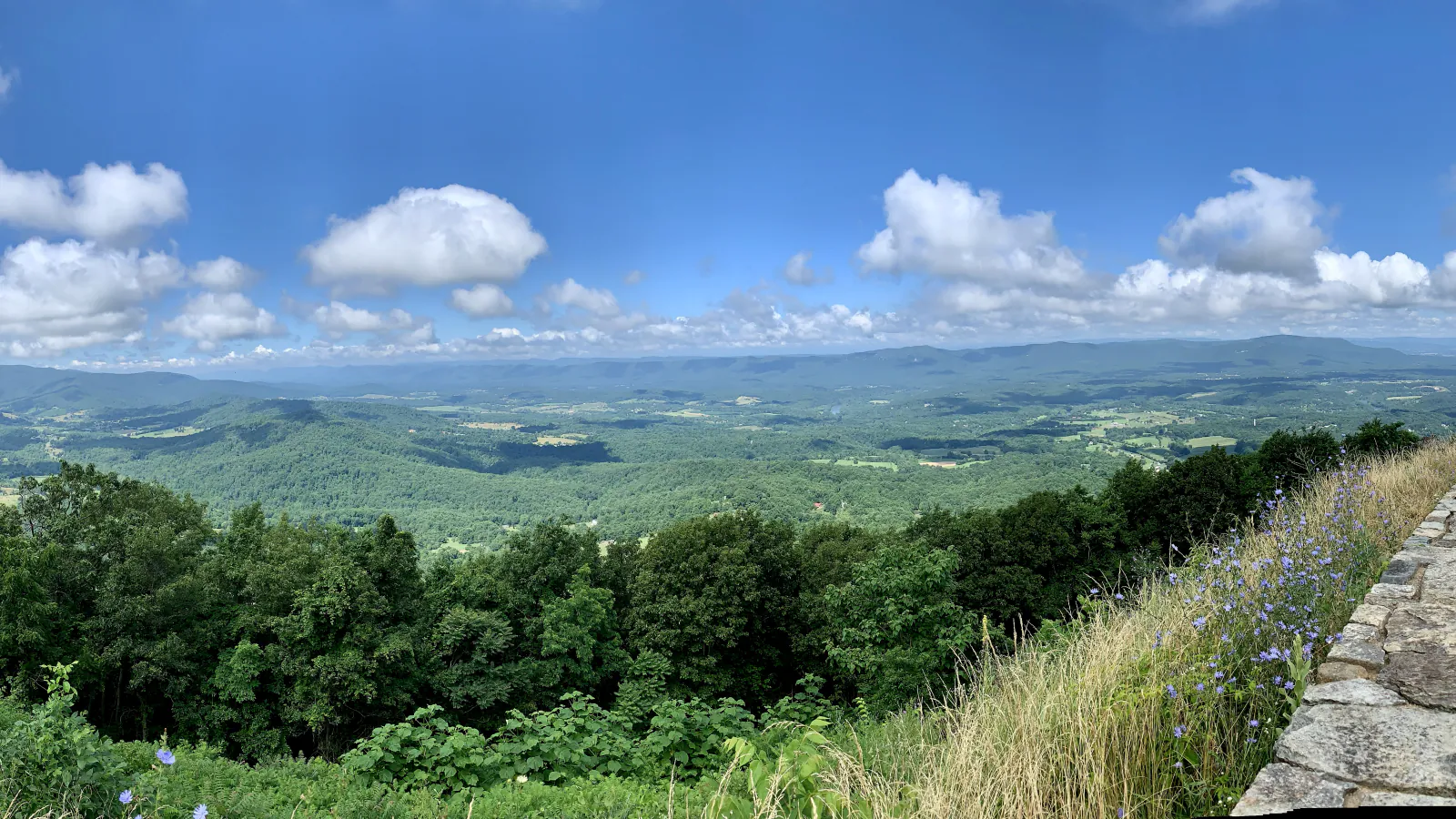
Featured image: APK / Wikimedia Commons Source · CC BY-SA 4.0

Shenandoah's trailheads sit along a 105-mile ridge road, so choosing the right hike is partly a transportation decision. A compact waterfall walk near Big Meadows and a summit in the South District can be separated by more than an hour of slow Skyline Drive travel. Build each day around one district, leave room for overlooks, and keep a second trail in the same area ready when a parking lot is full.
These fifteen routes run south to north, from Turk Mountain to Dickey Ridge. They include short rock summits, four waterfall outings, the Old Rag scramble, and quieter ridge walks. Distances on the cards come from the same route geometry used for the maps and elevation profiles; they can differ from rounded NPS signs or from a temporary detour.
Official access and safety guidance was checked on August 30, 2026. Old Rag's main lot is closed during a construction project expected to continue through November, although overflow lots remain available and day-use tickets are still required March 1 through November 30. Skyline Drive, trail, fire, and weather conditions can change sooner, so read the live panels and official links immediately before the hike.
Live park weather
Shenandoah National Park
Harry F. Byrd Sr. Visitor Center, Big Meadows
Loading the latest conditions and alerts…
What changes a hiking day here
Treat Skyline Drive as part of the itinerary
Skyline Drive is the only public road through the park, has a 35 mph speed limit, and can close in sections for severe weather. Do not stack distant trailheads into a tight schedule. Check the current road status, identify the closest entrance, and allow time for wildlife, fog, and crowded overlooks. Boundary trailheads can remain walkable when the ridge road is closed, but entrance fees and posted access rules still apply.
Reserve Old Rag before leaving service
Every visitor using Old Rag's Ridge, Saddle, or Ridge Access trails needs a dated day-use ticket from March 1 through November 30, in addition to a park entrance pass. Tickets are sold online and cell service at the entrance station is unreliable. During the 2026 construction project, the main parking lot is closed to vehicles and pedestrians; follow signs to the existing overflow lots and remember that a ticket does not guarantee parking.
Walk away from a full trailhead
NPS identifies Old Rag, Whiteoak Canyon, and Dark Hollow Falls among the park's busiest routes. Stony Man and Hawksbill also fill quickly in peak foliage season. Parking on vegetation, along an unsigned shoulder, or in front of a gate is not a solution. Use the alternate route named in the same district, or return outside the busiest hours.
Expect the return climb at every waterfall
Skyline Drive follows the ridge, so waterfall hikes commonly descend first and climb back to the car. Save water and energy for that reversal. Stay on the maintained tread and never step onto the top of a waterfall: wet greenstone and polished rock can be slick well beyond the visible flow, and falls in these areas have caused serious and fatal injuries.
Prepare for cooler, faster-changing ridge weather
NPS notes that mountaintop temperatures can be 10 to 20 degrees cooler than the valley. Fog, wind, thunderstorms, and winter ice can make a short summit route a different outing from the entrance forecast. Carry layers and a light, and turn around when wet rock compromises the Bearfence or Old Rag scramble.
Know the few trails where pets cannot go
Leashed pets are allowed on most Shenandoah trails, but the physical leash may be no longer than six feet. The selected routes that prohibit pets include Bearfence Mountain, Dark Hollow Falls, the blue-blazed Stony Man summit trail, and the Old Rag Ridge, Saddle, and Ridge Access trails. Carry waste out and check the current NPS list before choosing an alternative.
Give black bears a full escape route
Keep at least 150 feet from black bears and at least 75 feet from other wildlife. Never leave food or a scented pack unattended. If a bear occupies the trail, stay with your group, keep children close, and back away or detour without surrounding it. Watching from a distance protects both the animal and the next hiker.
Carry navigation that works offline
Cell and GPS service are unreliable in Shenandoah. Download the mobile map before entering the park, carry a detailed park map for complex junctions, tell someone the route and return time, and photograph any temporary trailhead notice. The route cards are planning aids, not a substitute for current signs, barriers, or ranger direction.
| Trail | Distance | Time | Difficulty | Best for |
|---|---|---|---|---|
| Turk Mountain Trail | 2.5 miles round trip | About 1 hour 41 minutes | Moderate | A compact South District summit |
| Calvary and Chimney Rocks Trail | 3.3 miles round trip | About 2 hours 30 minutes | Moderate | Geology and paired overlooks |
| Blackrock Summit Loop | 1.2 miles around the loop | About 1 hour | Easy | A short talus-slope panorama |
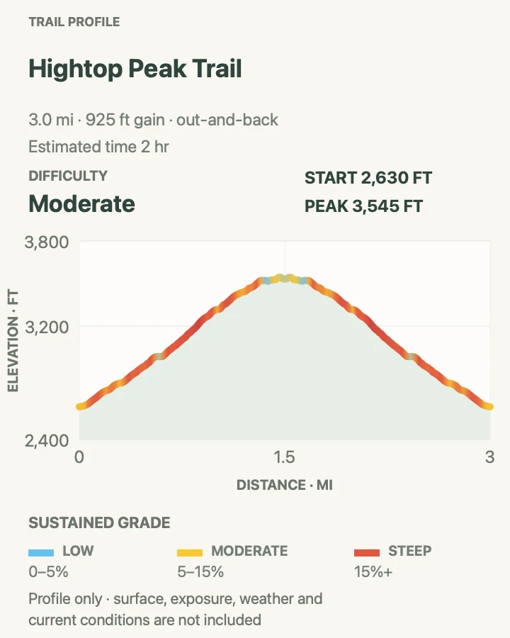
| Hightop Peak Trail | 3 miles round trip | About 2 hours | Moderate | A steady climb to a quieter viewpoint |
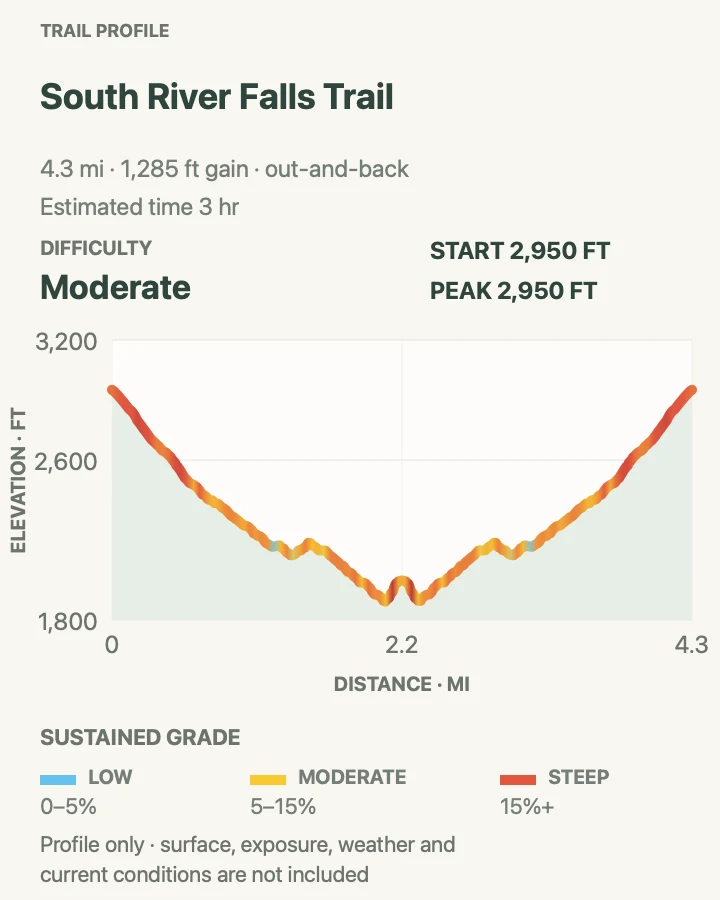
| South River Falls Trail | 4.4 miles round trip | About 3 hours | Moderate | A longer waterfall approach with a ridge-road trailhead |
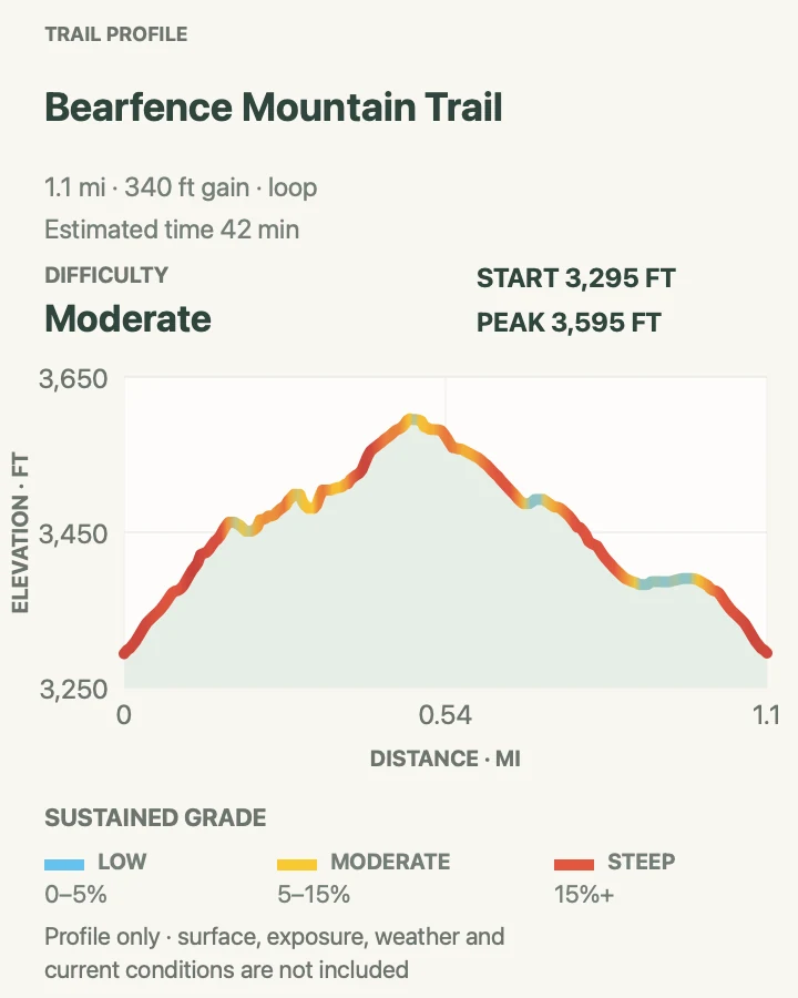
| Bearfence Mountain Trail | 1.1 miles around the loop | About 42 minutes | Moderate | A brief hands-on rock scramble |
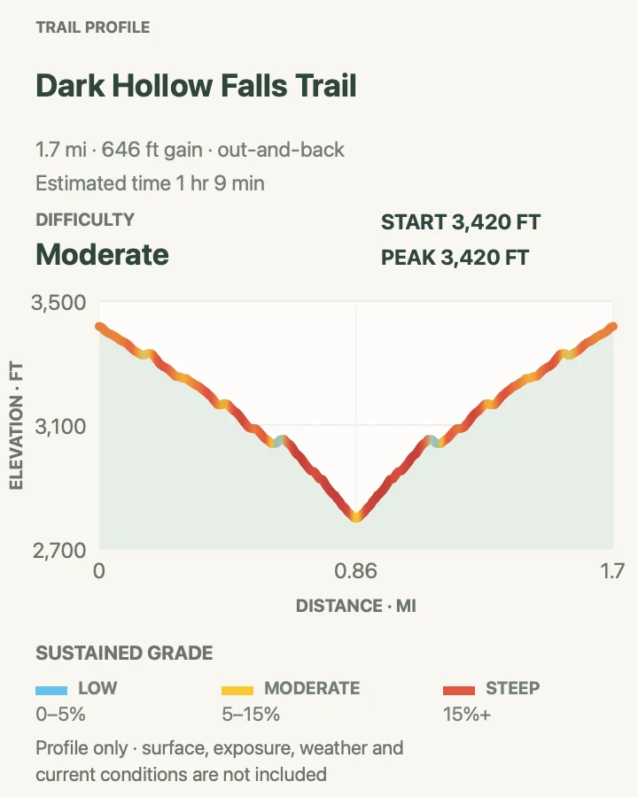
| Dark Hollow Falls Trail | 1.8 miles round trip | About 1 hour 9 minutes | Moderate | A short, steep waterfall walk |
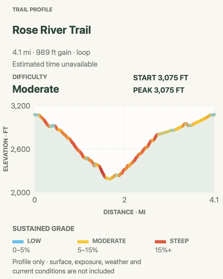
| Rose River Trail | 4.1 miles around the loop | No reliable source estimate | Moderate | A forest loop beside cascades and falls |
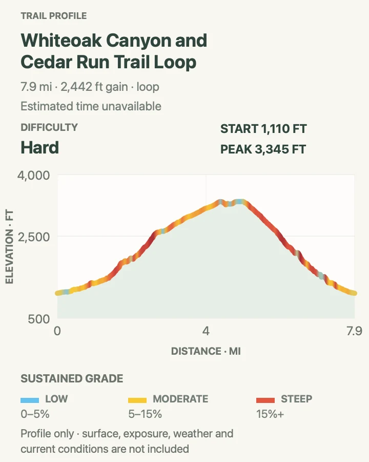
| Whiteoak Canyon and Cedar Run Trail Loop | 8.1 miles around the loop | No reliable source estimate | Hard | A demanding full canyon circuit |
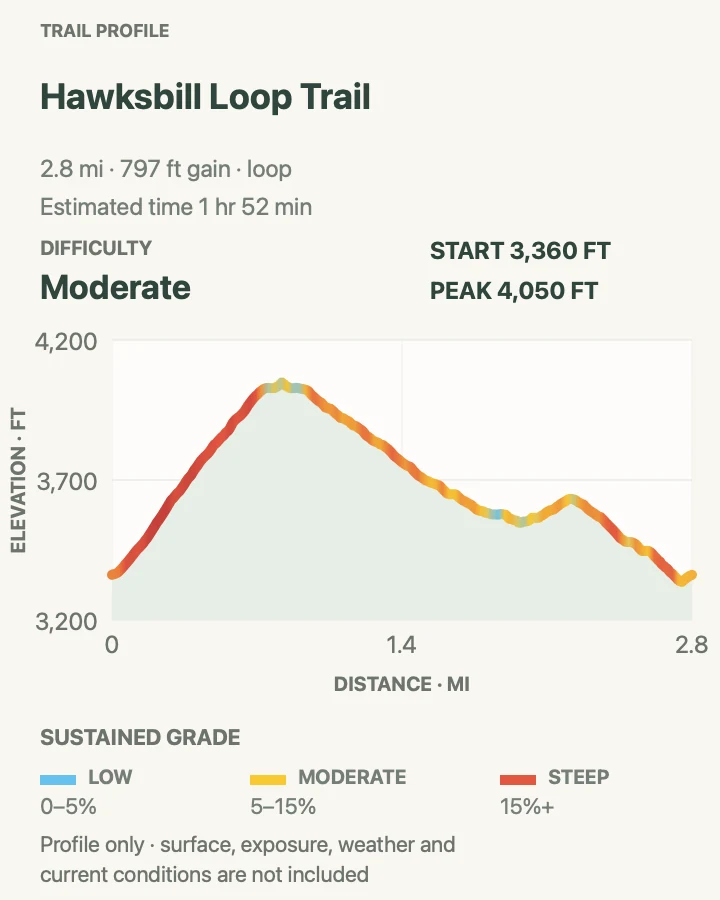
| Hawksbill Loop Trail | 2.8 miles around the loop | About 1 hour 52 minutes | Moderate | The park's highest summit in a compact loop |
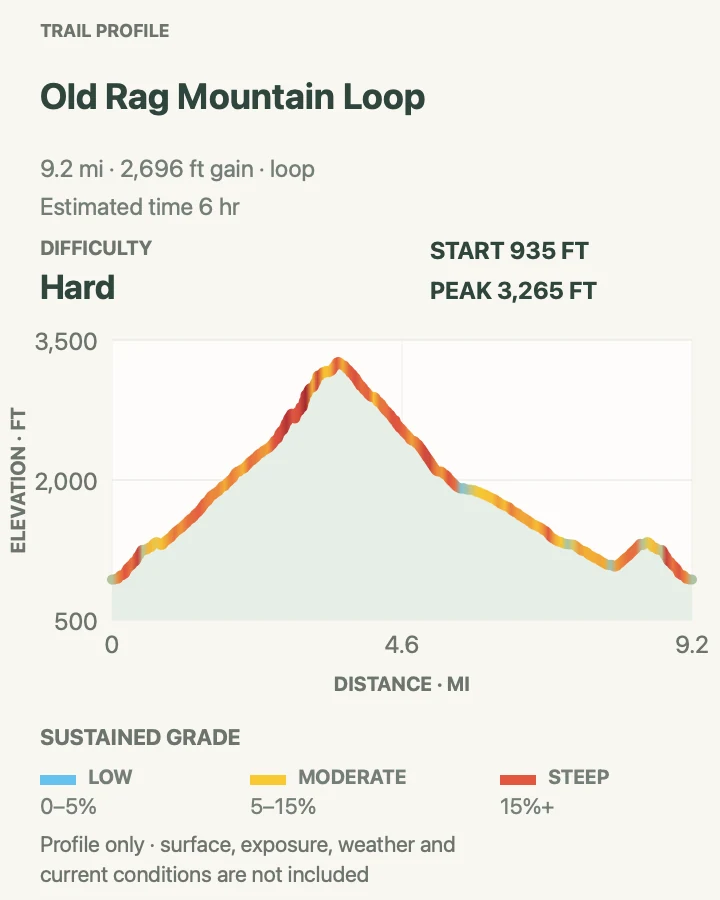
| Old Rag Mountain Loop | 9.3 miles around the loop | About 6 hours | Hard | A long, technical rock-scramble day |
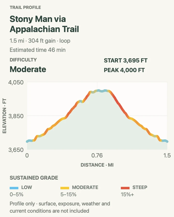
| Stony Man via Appalachian Trail | 1.5 miles around the loop | About 46 minutes | Moderate | A short cliff-top view near Skyland |
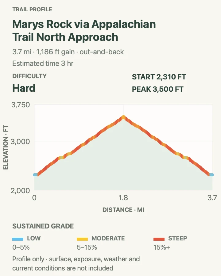
| Marys Rock via Appalachian Trail, North Approach | 3.8 miles round trip | About 3 hours | Hard | A direct climb to a broad northern-park view |
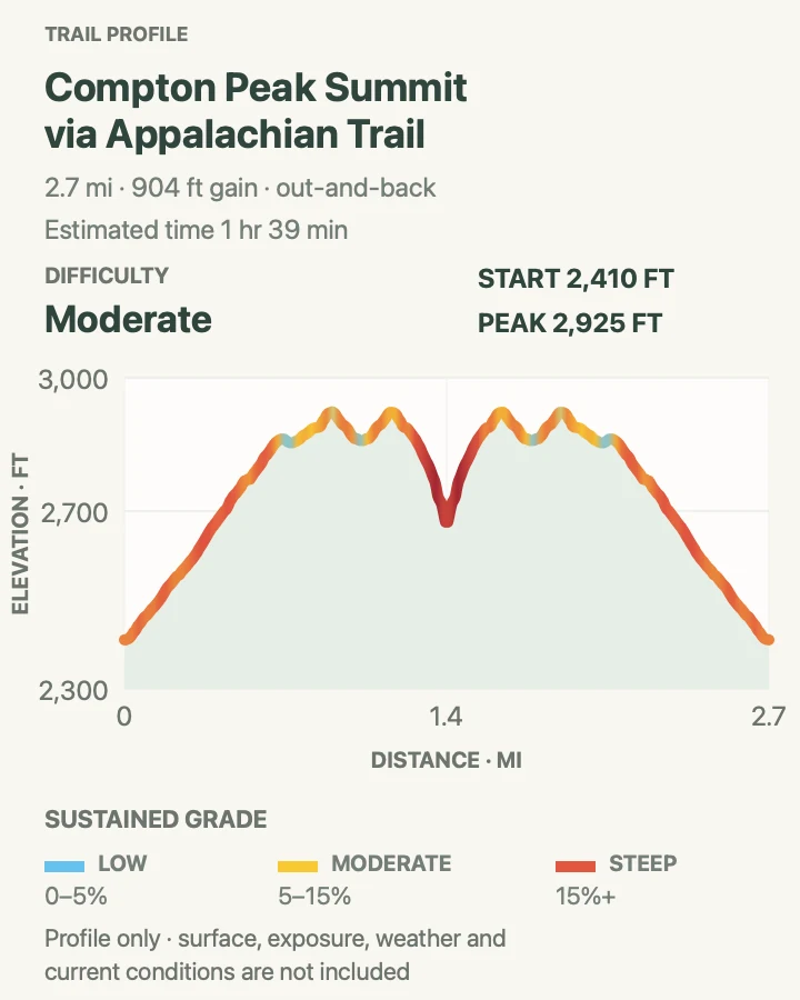
| Compton Peak Summit via Appalachian Trail | 2.8 miles round trip | About 1 hour 39 minutes | Moderate | A quieter northern Appalachian Trail summit |
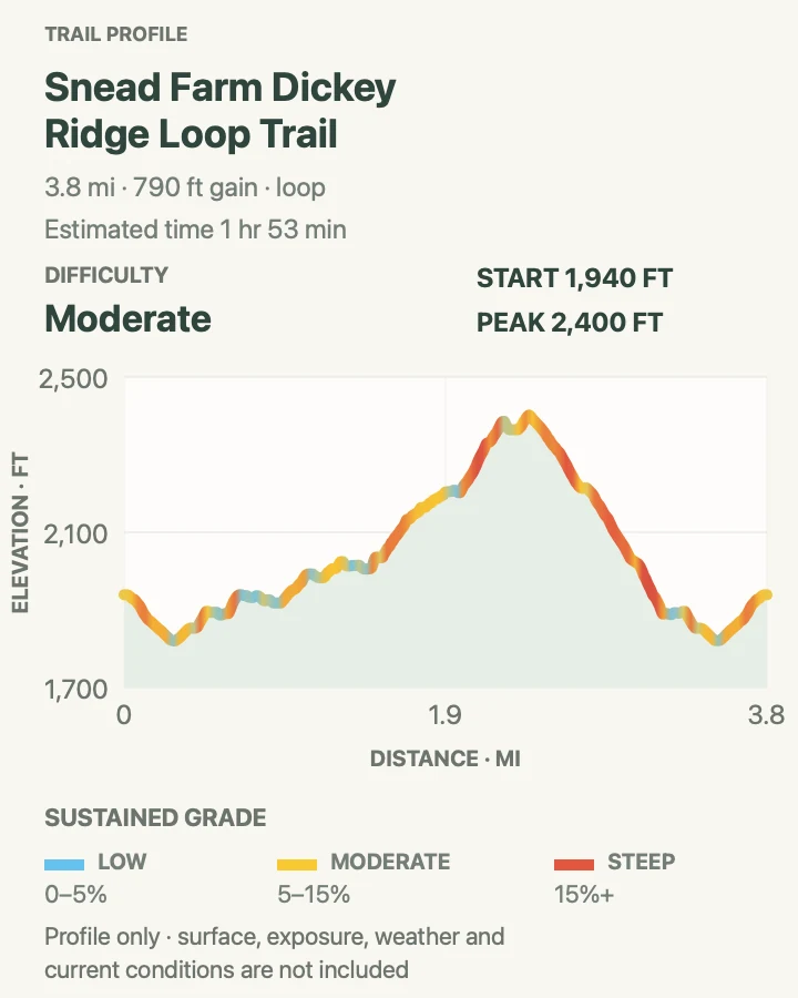
| Snead Farm–Dickey Ridge Loop Trail | 3.8 miles around the loop | About 1 hour 53 minutes | Moderate | A northern history walk with ridge scenery |
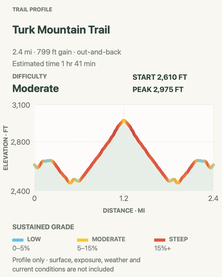
Turk Mountain Trail
- Distance
- 2.5 miles round trip
- Elevation gain
- 800 feet
- Time
- About 1 hour 41 minutes
- Difficulty
- Moderate
- Route type
- Out and back
- Parking
- Use the signed Turk Gap parking area on Skyline Drive; if every marked space is occupied, continue to another South District trail.
- Best time
- A clear spring or fall morning, before haze and afternoon heat soften the westward view.
- Pets
- Leashed pets are allowed; use a physical leash no longer than six feet.
Turk Mountain is a short ridge climb with a rockier finish than its mileage suggests. The route leaves Turk Gap, works through forest, and reaches exposed quartzite near the summit. Openings look west across the Shenandoah Valley rather than east into the park's deeper hollows.
The last section benefits from deliberate foot placement, especially when leaves hide loose stones. The trail is an efficient alternative when longer South District routes do not fit the day, but it is not a sunset stroll to attempt without a light; the wooded return darkens quickly.
What helps on this route
- Save the summit rocks for dry conditions; lichen and loose grit reduce traction after rain.
- Note the return junction at Turk Gap before climbing so the correct descent remains obvious.
Terrain and access: Wooded ridge trail with steady climbing, loose rock, and a short exposed summit approach.

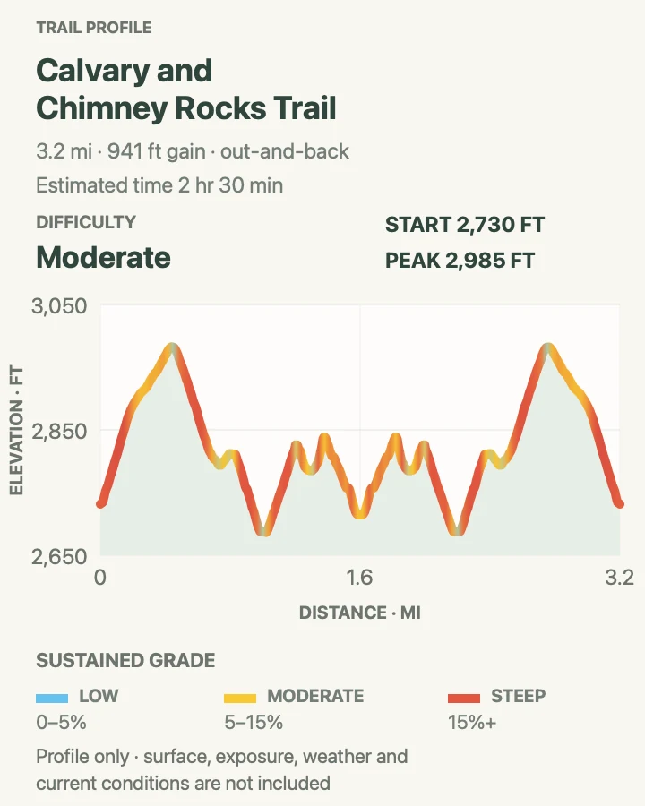
Calvary and Chimney Rocks Trail
- Distance
- 3.3 miles round trip
- Elevation gain
- 940 feet
- Time
- About 2 hours 30 minutes
- Difficulty
- Moderate
- Route type
- Out and back
- Parking
- Begin from the signed Riprap trail parking area on Skyline Drive and keep gates and road shoulders clear.
- Best time
- A dry, clear day when the South District rock overlooks are free of fog.
- Pets
- Leashed pets are allowed; use a physical leash no longer than six feet.
This outing follows the Appalachian Trail and side trail to two quartzite viewpoints. Calvary Rocks comes first; Chimney Rock extends the walk to a second ledge over the valley. The destinations belong to the same practical out-and-back, so they are treated as one route rather than duplicate cards.
Several rocky ledges invite wandering, but rare outcrop communities and steep edges reward restraint. Stay on the established approach, keep well back in wind or wet weather, and use the mapped turnaround rather than following informal scrambles beyond the viewpoint.
What helps on this route
- Budget time for both overlooks instead of turning every opening in the trees into a side path.
- Carry a layer even in warm valley weather; the exposed rock can be windy.
Terrain and access: Rolling Appalachian Trail tread followed by a rockier spur to unguarded quartzite ledges.

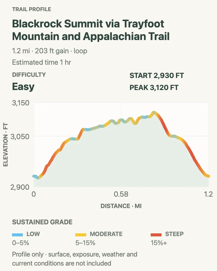
Blackrock Summit Loop
- Distance
- 1.2 miles around the loop
- Elevation gain
- 200 feet
- Time
- About 1 hour
- Difficulty
- Easy
- Route type
- Loop
- Parking
- Use the signed Blackrock parking area on Skyline Drive; do not park along vegetation when the small lot is full.
- Best time
- Morning or late afternoon in dry weather, with clear visibility across the South District.
- Pets
- Leashed pets are allowed; protect paws from sharp rock and use a physical leash no longer than six feet.
Blackrock's pale boulder field appears abruptly above the forest. This short loop uses the Appalachian Trail and the Trayfoot Mountain connection to circle the summit area without requiring a climb over the talus. The broad view arrives quickly, making the route useful for mixed-ability groups comfortable on uneven stone.
The boulder field is both habitat and unstable footing. Enjoy it from the maintained trail and established viewpoint rather than building cairns or climbing into gaps. At the loop junction, confirm the direction back to the parking area instead of continuing along the Appalachian Trail.
What helps on this route
- Keep children close near the edge of the talus and avoid stepping between large blocks.
- Check the map at the Trayfoot junction; through-hiker tread can make the longer continuation look more obvious.
Terrain and access: Short forest loop with rocky Appalachian Trail tread and an exposed talus overlook.

Hightop Peak Trail
- Distance
- 3 miles round trip
- Elevation gain
- 930 feet
- Time
- About 2 hours
- Difficulty
- Moderate
- Route type
- Out and back
- Parking
- Park only in the signed Hightop Mountain parking area, then cross Skyline Drive carefully to the Appalachian Trail.
- Best time
- A cool, leaf-off morning or a clear day outside peak fall crowds.
- Pets
- Leashed pets are allowed; use a physical leash no longer than six feet.
Hightop gains its view through a sustained Appalachian Trail climb rather than a scramble. NPS's South River area directions send hikers around the summit to a short side trail on the right; missing that turn means walking past the viewpoint on the white-blazed trail.
The forest makes this a calmer choice than the park's headline summits, but fallen leaves can conceal angular rock. Retrace the route from the side viewpoint and take care crossing Skyline Drive at the beginning and end of the outing.
What helps on this route
- Watch for the short viewpoint spur after the trail bends around the summit.
- Face traffic and cross Skyline Drive only when both directions are clear.
Terrain and access: Consistent wooded ascent on rocky Appalachian Trail tread with a short viewpoint spur.

South River Falls Trail
- Distance
- 4.4 miles round trip
- Elevation gain
- 1,290 feet
- Time
- About 3 hours
- Difficulty
- Moderate
- Route type
- Out and back
- Parking
- Use the South River Picnic Grounds parking area and begin below the comfort station on the blue-blazed trail.
- Best time
- Spring or after sustained rain, provided crossings and rocks remain safe.
- Pets
- Leashed pets are allowed; use a physical leash no longer than six feet.
South River Falls descends from the picnic grounds toward an overlook of the 83-foot waterfall. This mapped out-and-back continues beyond the shorter official observation-point option, accounting for its longer distance. Decide at the overlook whether conditions and remaining energy support the full line.
The climb is saved for the return to Skyline Drive. A stream crossing and damp stone can change after rain, so turn around before fast water or slippery footing becomes a problem. The waterfall is safest from the trail and designated views, never from the wet rock above it.
What helps on this route
- Keep enough water for the uphill return; the outbound descent can understate the effort.
- Use the observation point as a decision gate when water is high or the schedule is slipping.
Terrain and access: Long forest descent and return climb with rocky tread, a stream crossing, and damp waterfall terrain.

Bearfence Mountain Trail
- Distance
- 1.1 miles around the loop
- Elevation gain
- 340 feet
- Time
- About 42 minutes
- Difficulty
- Moderate
- Route type
- Loop
- Parking
- Use the signed Bearfence Mountain parking area on Skyline Drive and cross the road with care.
- Best time
- A dry morning with stable weather and no ice on the scramble.
- Pets
- Pets are prohibited on Bearfence Mountain Trail.
Bearfence compresses a real rock scramble into a short loop. The marked line uses hands and feet through narrow passages before reaching an open summit area, then returns by way of the Appalachian Trail. Distance alone does not describe the exposure or the need for comfortable movement on rock.
Skip the scramble when stone is wet or icy, when thunderstorms threaten, or when anyone in the group is uneasy with heights. Follow the blazes closely through the rock rather than choosing an easier-looking unofficial line, which can lead onto steeper terrain and damage fragile vegetation.
What helps on this route
- Stow loose items and keep both hands available before entering the scramble.
- Choose a non-scramble summit elsewhere in the guide if the rock is damp.
Terrain and access: Short but exposed rock scramble with tight moves, followed by rocky Appalachian Trail tread.

Dark Hollow Falls Trail
- Distance
- 1.8 miles round trip
- Elevation gain
- 650 feet
- Time
- About 1 hour 9 minutes
- Difficulty
- Moderate
- Route type
- Out and back
- Parking
- Use the signed Dark Hollow Falls parking area near Big Meadows; leave when marked spaces are unavailable.
- Best time
- Early morning on a weekday, especially after ordinary spring flow rather than a flood event.
- Pets
- Pets are prohibited on Dark Hollow Falls Trail.
Dark Hollow reaches a close view of its waterfall quickly, which helps explain both its appeal and its congestion. The route drops beside Hogcamp Branch on a steep, rocky path. Every foot descended must be regained on the way back to the parking lot.
Passing room is limited near the falls, and wet rock beyond the maintained tread is hazardous. Wait for space rather than stepping toward the stream. If the lot or overlook is crowded, Rose River offers a longer outing in the same general area without combining the two into an overlapping route family.
What helps on this route
- Use trekking poles only if they help on a steep return without obstructing other hikers on narrow tread.
- Keep off the rocks at the top and sides of the cascade, even when they appear dry.
Terrain and access: Steep, rocky streamside descent with damp steps, limited passing room, and a sustained return climb.

Rose River Trail
- Distance
- 4.1 miles around the loop
- Elevation gain
- 990 feet
- Time
- No reliable source estimate
- Difficulty
- Moderate
- Route type
- Loop
- Parking
- Use the signed Fishers Gap parking or overlook area and obey any temporary restrictions at the trail entrance.
- Best time
- A weekday morning in spring or after moderate rain, when the stream is active but crossings are safe.
- Pets
- Leashed pets are allowed on the mapped Rose River route; use a physical leash no longer than six feet.
Rose River makes a fuller streamside loop than Dark Hollow, passing cascades, the main falls, and forest junctions near a historic road trace. The preserved source's 52-hour duration is not credible for this 4.1-mile day hike, so the guide does not repeat it or substitute an invented estimate.
Use distance, elevation profile, daylight, and current water conditions to make your own time plan. Junctions around Rose River Fire Road and the connecting trail deserve attention, and rocks near every cascade remain slippery. The mapped loop stands on its own rather than adding the overlapping Dark Hollow spur.
What helps on this route
- Download the mobile map before leaving service; several intersecting paths make memory-based navigation unreliable.
- Turn around at a crossing that is fast, deep, or obscures the next safe step.
Terrain and access: Rocky forest loop with streamside sections, cascades, road-trace walking, and several junctions.

Whiteoak Canyon and Cedar Run Trail Loop
- Distance
- 8.1 miles around the loop
- Elevation gain
- 2,440 feet
- Time
- No reliable source estimate
- Difficulty
- Hard
- Route type
- Loop
- Parking
- Use the signed Whiteoak Canyon parking area on Skyline Drive; do not begin if the lot is full or the return would extend beyond daylight.
- Best time
- A cool weekday with safe stream levels and dry enough rock for the steep canyon sections.
- Pets
- Leashed pets are allowed; the steep, rocky loop may be unsuitable for many animals.
Whiteoak Canyon and Cedar Run form one demanding circuit through the park's waterfall-cut greenstone terrain. The route drops past multiple cascades, crosses the drainage, and regains the ridge through Cedar Run. It is retained instead of shorter overlapping Whiteoak variants because it represents the complete, distinct canyon day.
The source reports an implausible 52-hour duration, so no visitor-facing time estimate is offered. Plan from the measured distance and profile, start early, and expect the closing climb to Skyline Drive. High water, ice, heat, or a late start are all sound reasons to choose a shorter route.
What helps on this route
- Carry enough water and food for a long day even though streams are frequent; untreated water is not a planning substitute.
- Check every crossing and waterfall approach from the maintained tread before committing to the lower canyon.
Terrain and access: Steep, sustained canyon loop with rocky descents, stream crossings, waterfalls, and a long climb back to the ridge.

Hawksbill Loop Trail
- Distance
- 2.8 miles around the loop
- Elevation gain
- 800 feet
- Time
- About 1 hour 52 minutes
- Difficulty
- Moderate
- Route type
- Loop
- Parking
- Use the signed Hawksbill Gap parking area; Upper Hawksbill is a different approach and is not part of this mapped loop.
- Best time
- A clear weekday morning before summit congestion or afternoon thunderstorms.
- Pets
- Leashed pets are allowed; use a physical leash no longer than six feet.
This circuit reaches Hawksbill's viewing platform, the highest summit in Shenandoah, by combining the steeper lower approach with the Appalachian and Salamander trails. It gives the summit route a loop shape without duplicating the separate Upper Hawksbill and Hawksbill Summit records in the source inventory.
The platform and nearby outcrops can be busy even when the lower trail feels quiet. Remain inside established travel areas, keep food secured, and follow the mapped descent at each junction. Fog may erase the view while still leaving wet, slippery stone underfoot.
What helps on this route
- Confirm the loop direction at the Appalachian Trail and Salamander junctions before descending.
- Bring a layer for the summit; wind and temperature can differ sharply from the parking area.
Terrain and access: Steep forest climb, rocky summit area, and a longer rolling return on marked connecting trails.

Old Rag Mountain Loop
- Distance
- 9.3 miles around the loop
- Elevation gain
- 2,700 feet
- Time
- About 6 hours
- Difficulty
- Hard
- Route type
- Loop
- Parking
- During the 2026 construction closure, follow signs to the existing Old Rag overflow lots; the main lot is closed to vehicles and pedestrians through the expected November completion.
- Best time
- A dry weekday with a reserved ticket, an early start, and stable weather.
- Pets
- Pets are prohibited on the Old Rag Ridge, Saddle, and Ridge Access trails used by this loop.
Old Rag is the guide's most committing route. The loop climbs the Ridge Trail, works through a long sequence of granite scramble moves, reaches the summit, and returns by the Saddle and fire-road system. The exposed rock and narrow passages can create delays that mileage and average pace do not capture.
From March 1 through November 30, every person needs an advance day-use ticket plus a park entrance pass. In 2026, construction closes the main lot, so use only signed overflow parking. Do not attempt the scramble when rock is wet or icy, and carry a light, extra layers, food, and water in case the circuit takes longer than planned.
What helps on this route
- Save a screenshot or printout of every ticket before driving to the trailhead; cellular service is unreliable.
- Keep both hands free in the scramble and avoid bulky packs that snag in narrow passages.
Terrain and access: Long granite scramble with tight passages and exposure, followed by rocky trails and a sustained fire-road return.

Stony Man via Appalachian Trail
- Distance
- 1.5 miles around the loop
- Elevation gain
- 300 feet
- Time
- About 46 minutes
- Difficulty
- Moderate
- Route type
- Loop
- Parking
- Use the signed Stony Man parking area near Skyland and follow current directional signs through the trail network.
- Best time
- An early weekday morning or a clear leaf-off day before the small summit becomes crowded.
- Pets
- Pets may use the Appalachian Trail portion but are prohibited on the blue-blazed Stony Man summit trail, so they cannot complete this mapped loop.
Stony Man reaches a greenstone cliff through a short network near Skyland. The route uses part of the Appalachian Trail before turning onto the blue-blazed summit trail, then closes the loop through the signed junctions. That final turn matters for both navigation and the park's pet restriction.
The overlook is unguarded and supports sensitive rock-outcrop habitat. Stop on established stone, keep away from the outer edge in wind or fog, and do not create room by trampling vegetation. The selected loop replaces two substantially overlapping Stony Man source variants.
What helps on this route
- Read the concrete posts at every junction; nearby Skyland paths can make the return direction less obvious.
- Choose Compton Peak or another pet-allowed route rather than stopping at the prohibited Stony Man spur.
Terrain and access: Short forest loop with rocky tread, several junctions, and an exposed, unrailed summit cliff.

Marys Rock via Appalachian Trail, North Approach
- Distance
- 3.8 miles round trip
- Elevation gain
- 1,190 feet
- Time
- About 3 hours
- Difficulty
- Hard
- Route type
- Out and back
- Parking
- Use the signed Panorama parking area near Thornton Gap and locate the Appalachian Trail crossing before starting.
- Best time
- A cool, clear weekday before the Thornton Gap lots and summit outcrop fill.
- Pets
- Leashed pets are allowed; use a physical leash no longer than six feet.
The north approach climbs from Thornton Gap on the Appalachian Trail, then takes the short summit spur to Marys Rock. It is the most-reviewed representative of three substantially overlapping Marys Rock routes in the source set, avoiding separate cards for the southern and Pinnacles approaches.
The ascent is rocky and sustained, while the summit ledge is exposed and environmentally sensitive. Yield where the trail narrows, keep dogs under close control, and stay within the established outcrop area. Descend the same route rather than improvising a loop through unfamiliar junctions.
What helps on this route
- Lock valuables out of sight and carry needed items; boundary-adjacent parking can be busy.
- Pause at the summit spur junction on the return so the northbound descent is unmistakable.
Terrain and access: Sustained rocky Appalachian Trail climb to an exposed summit spur and unguarded ledge.

Compton Peak Summit via Appalachian Trail
- Distance
- 2.8 miles round trip
- Elevation gain
- 900 feet
- Time
- About 1 hour 39 minutes
- Difficulty
- Moderate
- Route type
- Out and back
- Parking
- Use the signed Compton Gap parking area near the North Entrance and cross Skyline Drive only when traffic is clear.
- Best time
- A leaf-off morning for broader views, or a cool summer day for the shaded ridge walk.
- Pets
- Leashed pets are allowed; use a physical leash no longer than six feet.
Compton Peak follows the Appalachian Trail from its namesake gap to a summit junction with separate viewpoint spurs. One reveals a columnar greenstone formation; the other opens toward the valley. The main walk is wooded and more subdued than Marys Rock or Stony Man.
The two short summit spurs require returning to the central junction rather than cutting between them. Stay on durable rock at the geologic exposure, leave stones in place, and budget enough time to cross Skyline Drive safely at the end of the hike.
What helps on this route
- Visit each signed viewpoint spur from the summit junction instead of attempting an informal connector.
- Listen for road traffic before stepping out of the trees at Compton Gap.
Terrain and access: Rolling, rocky Appalachian Trail ascent with two short summit spurs and a road crossing.

Snead Farm–Dickey Ridge Loop Trail
- Distance
- 3.8 miles around the loop
- Elevation gain
- 790 feet
- Time
- About 1 hour 53 minutes
- Difficulty
- Moderate
- Route type
- Loop
- Parking
- Use the Dickey Ridge visitor or picnic-area parking identified by current signs; facility hours do not control whether the trail itself is open.
- Best time
- Spring wildflower season or a cool fall morning outside entrance-line peaks.
- Pets
- Leashed pets are allowed; use a physical leash no longer than six feet.
This loop links Dickey Ridge with the Snead Farm home site and traces. Openings around the former farm interrupt the forest and give the route a cultural-history focus unlike the rocky summits farther south. Concrete posts and road traces shape the circuit.
Historic remains should be observed in place, not climbed or collected. The loop is near the Front Royal entrance, where traffic can build during busy periods, so separate the hiking plan from visitor-center hours and follow any temporary parking direction at Dickey Ridge.
What helps on this route
- Photograph the trailhead diagram before starting so the return leg through the road-trace network stays clear.
- Check for ticks after walking through the more open farm-site vegetation.
Terrain and access: Moderate forest loop with old road grades, meadow-edge vegetation, historic traces, and signed junctions.

Official planning sources
Trail access and safety details were checked against these National Park Service pages. The maps and profiles follow the corresponding route geometry.
- NPS: Alerts and conditions
- NPS: Hiking basics
- NPS: Recommended day hikes
- NPS: Trail maps
- NPS: Old Rag day-use tickets and 2026 construction
- NPS: Pet rules and prohibited trails
- NPS: General hiking and waterfall safety
- NPS: Bear safety
- NPS: Skyline Drive status and planning
- NPS: 2026 operating dates and hours
- NPS: South River and Hightop trail map
- NPS: Old Rag road and trail map
Map data © OpenStreetMap contributors. Trail geometry and planning details include National Park Service public information.