10 Best Hikes in New River Gorge National Park
Ten New River Gorge hikes with reviewed terrain maps, elevation profiles, parking notes, and current NPS planning links.
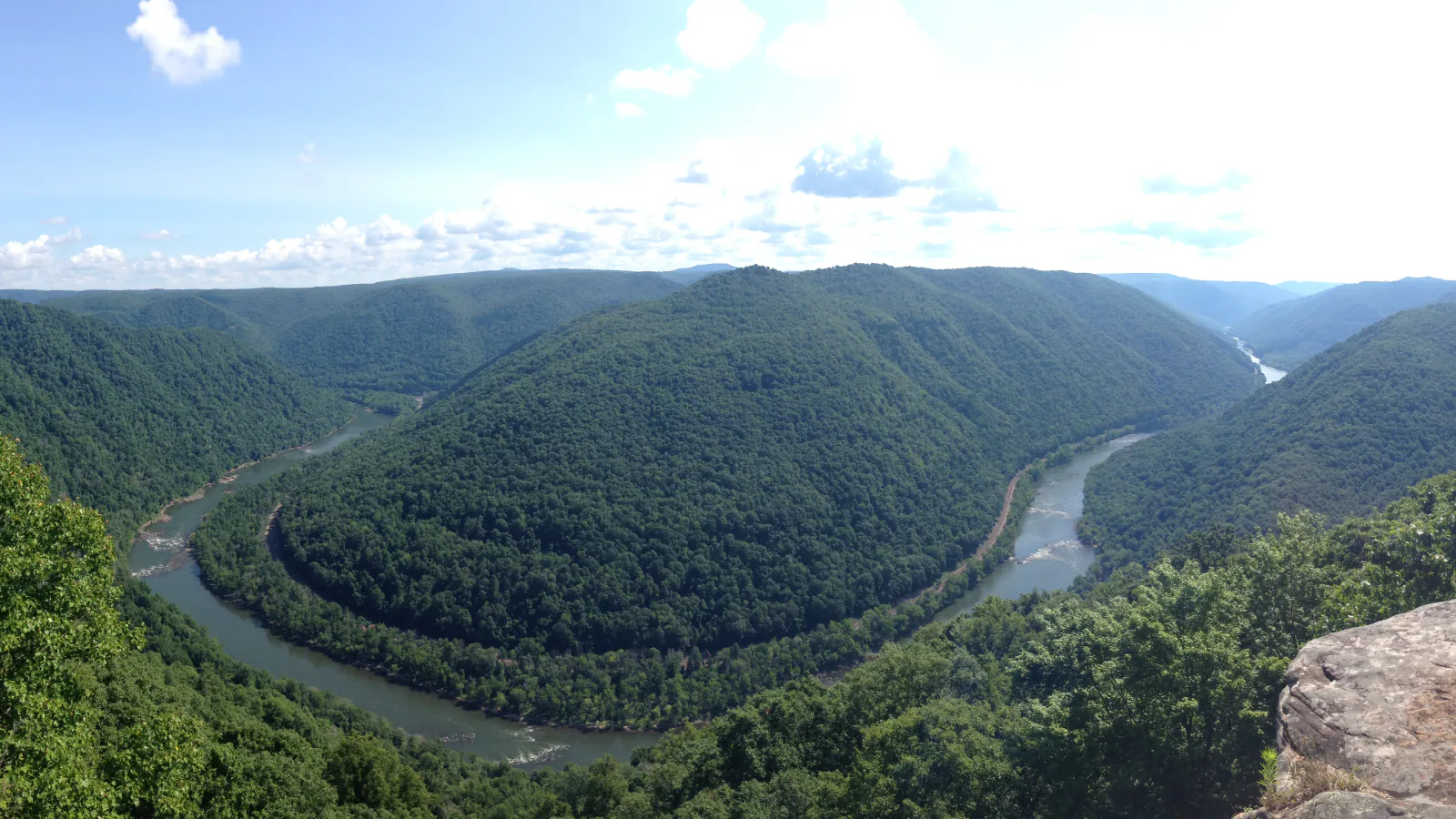
New River Gorge stretches along more than fifty miles of river, so the useful question is rarely which trail ranks first. It is which cluster fits the day. Endless Wall and Kaymoor sit near Fayetteville, Grandview has its own rim network, Glade Creek requires a separate approach, and Sandstone Falls is far south of the bridge.
These ten routes include the park's familiar overlooks and several walks that solve a different need: a waterfall day, an industrial-history descent, a near-level lake loop, or a longer circuit away from the shortest viewpoint traffic. Each terrain map and elevation profile comes from the reviewed route line shown with that hike. Distances can differ from NPS figures when the recorded route adds a connector or turns around at a different point.
Official conditions and trail-planning pages were checked on August 29, 2026. New River Gorge has small trailhead lots, narrow river roads, steep cliff edges, and limited mobile service. Recheck the park's closure and weather links on the morning of the hike.
What changes a hiking day here
Choose one part of the gorge
Endless Wall, Diamond Point, Fayetteville, and Kaymoor can anchor a north-end day. Grandview is a separate rim destination. Glade Creek and Sandstone Falls belong to the southern half of the park. Driving from one end to the other takes longer than the map suggests because many access roads descend to river level.
Keep a second trailhead in mind
NPS warns that many lots are small and can fill quickly. Endless Wall is especially sensitive to parking pressure. Do not park along roads or block gates; move to another selected route and return outside the busiest hours.
Rain changes the footing
Wet sandstone, wooden stairs, roots, and leaf-covered rock can all become slick. Glade Creek can be muddy, and the long approach from its upper trailhead uses a steep, narrow, unpaved road. The campground-side access is the more straightforward choice for most vehicles.
Mining remains are not shortcuts
Kaymoor and Fayetteville pass through an industrial landscape with old structures, openings, and steep grades. NPS says not to enter mines, coke ovens, or abandoned buildings. Loose surfaces and deteriorated remains are part of the hazard, not an invitation to explore off trail.
Leashed pets are allowed, with practical limits
Pets may use park trails on a physical leash no longer than six feet. Carry water because trailheads do not provide it and untreated streams may carry Giardia. Pick up waste and keep dogs back from cliffs, fast water, wildlife, and other trail users. Boley Lake is in Babcock State Park, so check the current state-park rules for that one route.
| Trail | Distance | Time | Difficulty | Best for |
|---|---|---|---|---|
| Endless Wall Trail | About 5.2 miles on the reviewed out-and-back track | 2 hr 5 min | Moderate | A substantial rim walk with repeated gorge viewpoints |
| Grandview Rim Trail to Turkey Spur Rock | About 3.2 miles round trip | 1 hr 11 min | Moderate | A compact rim hike with more walking than a drive-up overlook |
| Glade Creek Trail to Kates Falls | About 9.2 miles round trip on the reviewed track | 3 hr 25 min | Moderate | A long creekside day with cascades and a waterfall objective |
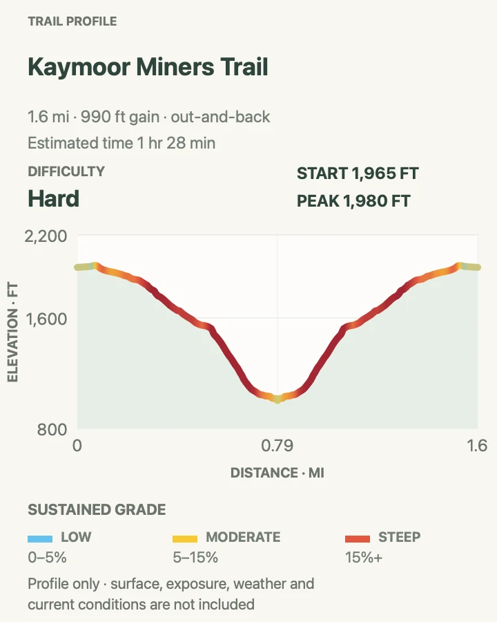
| Kaymoor Miners Trail | About 1.6 miles round trip on the reviewed descent | 1 hr 28 min | Hard | A steep history-focused descent rather than an easy viewpoint walk |
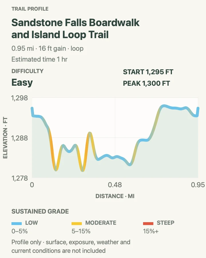
| Sandstone Falls Boardwalk and Island Loop Trail | About 1 mile for the reviewed boardwalk-and-island loop | 1 hr | Easy | A short waterfall walk with an accessible boardwalk segment |
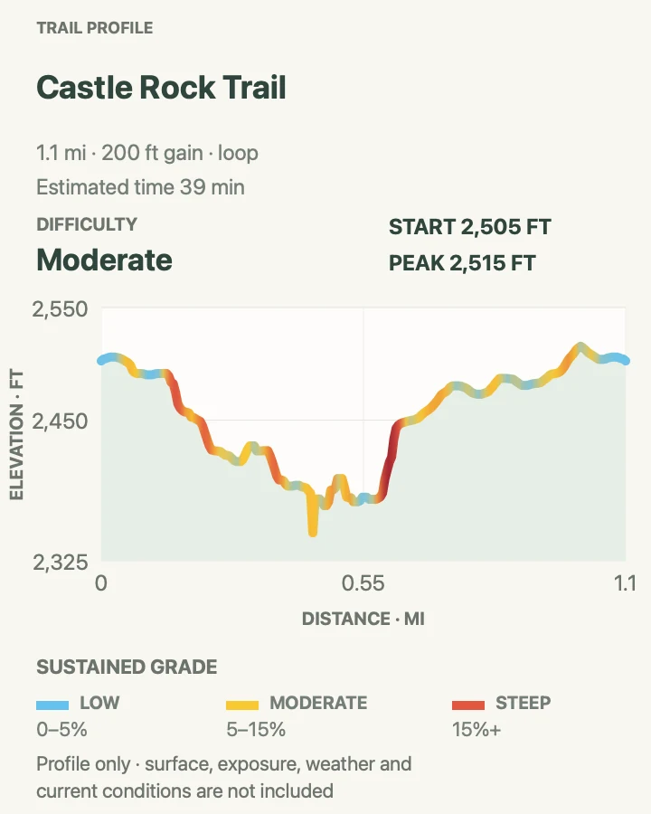
| Castle Rock Trail | About 1.1 miles as a reviewed loop | 39 min | Moderate | Close-up sandstone formations in a short Grandview circuit |
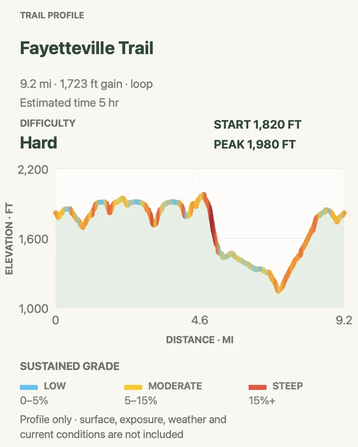
| Fayetteville Trail | About 9.2 miles on the reviewed loop | 5 hr | Hard | A long north-end circuit connecting forest, gorge, and historic travel corridors |
| Diamond Point Overlook via Endless Wall Trail | About 2.1 miles round trip on the reviewed track | 1 hr | Moderate | Reaching the signature rim viewpoint with less mileage than the long Endless Wall route |
| Boley Lake View Trail | About 1.2 miles around Boley Lake | 1 hr | Easy | A quieter, mostly level lake loop near the national park |
| Tunnel Trail | About 0.6 mile as a reviewed loop | 17 min | Easy | A brief forest-and-rock loop when time or stamina is limited |
Endless Wall Trail
- Distance
- About 5.2 miles on the reviewed out-and-back track
- Elevation gain
- 960 feet
- Time
- 2 hr 5 min
- Difficulty
- Moderate
- Route type
- out-and-back
- Parking
- Use a signed Endless Wall trailhead lot on Lansing-Edmond Road; spaces are limited and roadside parking is not a safe substitute.
- Best time
- Early morning on a dry day, with fall foliage as the busiest seasonal draw.
- Pets
- Leashed pets are allowed; keep them well back from cliff edges.
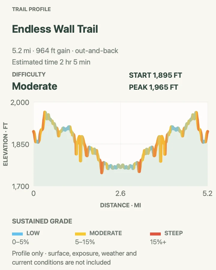
Endless Wall earns its name from the sandstone band that repeatedly appears through the forest. The reviewed out-and-back uses a longer portion of the trail than the common point-to-point walk and reaches the Diamond Point area without needing a roadside return.
The elevation profile looks rolling rather than severe, but the accumulated climbing approaches one thousand feet. Roots, rock steps, side paths used by climbers, and unguarded overlooks slow the pace. Treat every rim opening as an edge, especially when leaves or fog hide the drop.
What helps on this route
- Photograph the trailhead map before leaving mobile service.
- If both signed lots are full, switch to another Fayetteville-area route instead of improvising a parking space.
Terrain and access: Forested singletrack, roots, sandstone ledges, repeated short climbs, exposed overlooks, and little edge protection.

Grandview Rim Trail to Turkey Spur Rock
- Distance
- About 3.2 miles round trip
- Elevation gain
- 540 feet
- Time
- 1 hr 11 min
- Difficulty
- Moderate
- Route type
- out-and-back
- Parking
- Park in the Grandview day-use area and begin near the Main Overlook; follow signs for the Rim Trail and Turkey Spur.
- Best time
- Morning or late afternoon from spring through fall; allow extra care after rain.
- Pets
- Leashed pets are allowed; stairs and cliff exposure require close control.
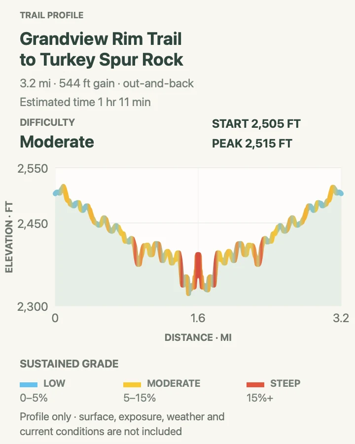
The Grandview Rim Trail leaves the developed overlook and follows the high wall above the deepest part of the gorge. It is short enough for a half day yet varied enough to feel like a hike, with rock formations, wooded tread, and a final viewpoint at Turkey Spur.
The return repeats several small climbs that are easy to discount on the outward leg. Turkey Spur also involves stairs. Grandview has six miles of interconnected trails, so check signs carefully rather than following every branch that appears to continue along the rim.
What helps on this route
- Add the Main Overlook before the trail while the light is favorable.
- Keep children and pets beside you at overlooks; barriers are not continuous.
Terrain and access: Wooded rim path, stone and wooden stairs, roots, short climbs, rock outcrops, and exposed gorge viewpoints.

Glade Creek Trail to Kates Falls
- Distance
- About 9.2 miles round trip on the reviewed track
- Elevation gain
- 750 feet
- Time
- 3 hr 25 min
- Difficulty
- Moderate
- Route type
- out-and-back
- Parking
- Start from the Glade Creek Campground trailhead for the more straightforward road approach; the upper approach is steep, narrow, and unpaved.
- Best time
- Spring flow or a cool day after moderate rain, avoiding flood conditions.
- Pets
- Leashed pets are allowed; bring their drinking water rather than using the creek.
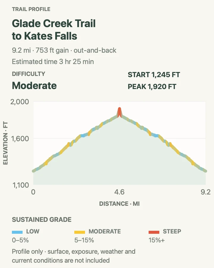
Glade Creek is a different New River Gorge day from the north-rim overlooks. The route stays with water for much of its length, passing pools, cascades, and damp forest before reaching the Kates Falls area. The reviewed track makes this a full outing rather than the shortest waterfall visit.
Mud and wet rock matter more than the moderate label suggests. High water can change stream edges and crossings, while summer vegetation can narrow the tread. The campground-side start avoids committing an ordinary passenger car to the rougher upper access road.
What helps on this route
- Download the Glade Creek area map before driving into the valley.
- Turn back if water is rising or a crossing no longer matches the mapped route.
Terrain and access: Creekside singletrack, mud, roots, wet rock, gradual grades, small drainage crossings, and limited mobile service.

Kaymoor Miners Trail
- Distance
- About 1.6 miles round trip on the reviewed descent
- Elevation gain
- 990 feet
- Time
- 1 hr 28 min
- Difficulty
- Hard
- Route type
- out-and-back
- Parking
- Use the small Kaymoor Top trailhead lot at the end of Kaymoor Road; the lot is narrow and unsuitable for RVs or trailers.
- Best time
- A dry, cool morning when the stairs and rock are not slick.
- Pets
- Leashed pets are allowed, but the grade and long stair sections are poor fits for many dogs.
Kaymoor compresses almost a thousand feet of climbing into a short round trip. The upper trail drops on rocky switchbacks to the mine bench. Continuing lower adds the famous wooden stair system and makes the return a sustained climb rather than a casual history stop.
The mining remains are fragile and can be dangerous. Stay on the established route, do not enter openings or structures, and do not climb on the ruins. Anyone who reaches the lower section still has to reverse every stair and switchback.
What helps on this route
- Budget the effort for the ascent, not the quick downhill time.
- Skip the lower stairs if wet wood, fatigue, or knee strain is already a concern.
Terrain and access: Very steep rocky switchbacks, long wooden stairs, industrial remains, loose surfaces, and a demanding return climb.

Sandstone Falls Boardwalk and Island Loop Trail
- Distance
- About 1 mile for the reviewed boardwalk-and-island loop
- Elevation gain
- 15 feet
- Time
- 1 hr
- Difficulty
- Easy
- Route type
- loop
- Parking
- Use the Sandstone Falls day-use lot at the end of New River Road, about a 45-minute drive from Sandstone Visitor Center.
- Best time
- Morning light or late-day quiet; avoid the river edge during high water.
- Pets
- Leashed pets are allowed; keep them out of the swift river channels.
Sandstone Falls spreads across roughly 1,500 feet of the New River. The accessible boardwalk crosses channels to observation areas, while the Island Loop adds a natural-surface circuit through floodplain forest and the unusual riverside flatrock plant community.
This is the flattest route in the guide, but the surrounding water is powerful. Remain on the boardwalk and established trail near the falls. The drive is part of the commitment: New River Road narrows to one lane in places and has limited passing room.
What helps on this route
- Do not confuse Sandstone Visitor Center with the falls trailhead.
- Large RVs are a poor fit for the final narrow approach road.
Terrain and access: Accessible boardwalk and bridges followed by a mostly level natural-surface island loop beside swift water.

Castle Rock Trail
- Distance
- About 1.1 miles as a reviewed loop
- Elevation gain
- 200 feet
- Time
- 39 min
- Difficulty
- Moderate
- Route type
- loop
- Parking
- Use the Grandview day-use parking area and follow the signed Grandview trail network to Castle Rock.
- Best time
- A dry day from spring through fall.
- Pets
- Leashed pets are allowed; rock gaps and steep tread demand close control.
Castle Rock trades the broad river panorama for a closer look at the geology holding up the rim. The trail works below and beside fractured sandstone walls, then reconnects with the Grandview network to complete a short loop.
A one-mile figure can be misleading here. Rock steps, narrow tread, and damp leaves make the route slower than a surfaced park path. Pair it with the Main Overlook or Tunnel Trail when the Grandview Rim Trail is more mileage than the day needs.
What helps on this route
- Follow the signed loop direction rather than scrambling into rock openings.
- After rain, test each stone step before committing weight.
Terrain and access: Narrow forest tread, sandstone walls, rock steps, roots, short steep pitches, and slippery leaves after rain.

Fayetteville Trail
- Distance
- About 9.2 miles on the reviewed loop
- Elevation gain
- 1,720 feet
- Time
- 5 hr
- Difficulty
- Hard
- Route type
- loop
- Parking
- Use Fayetteville Town Park for the simplest access to the local trail network; verify the intended connections on the posted map.
- Best time
- A cool, dry day with enough daylight for a five-hour outing.
- Pets
- Leashed pets are allowed; carry enough water for the full loop.
Fayetteville Trail is the mileage choice in this list. It links the town-side network with the gorge landscape and overlaps a corridor once used to reach the river communities below. The reviewed loop adds more than 1,700 feet of climbing across repeated descents and recoveries.
Several trail connections make navigation more important than on an isolated out-and-back. Begin with the local map saved offline and confirm each junction before leaving it. Mountain bikes also use parts of the Fayetteville-area system, so keep to one side where sight lines are short.
What helps on this route
- Carry the route offline and note the named junctions that close the loop.
- Leave enough energy for the final climb back toward town.
Terrain and access: Long forest circuit, sustained climbing, old road grades, roots, junctions, and shared-use trail segments.

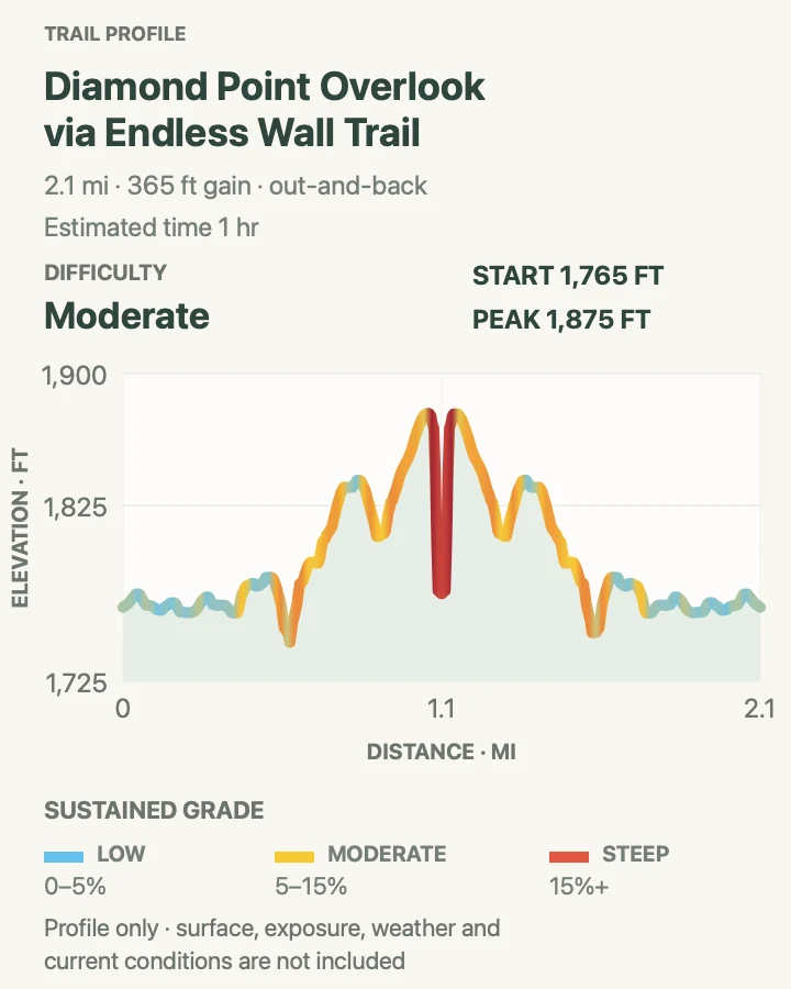
Diamond Point Overlook via Endless Wall Trail
- Distance
- About 2.1 miles round trip on the reviewed track
- Elevation gain
- 360 feet
- Time
- 1 hr
- Difficulty
- Moderate
- Route type
- out-and-back
- Parking
- Use a signed Endless Wall trailhead lot on Lansing-Edmond Road; do not create a roadside space if the lot is full.
- Best time
- Early morning or late afternoon on a clear, dry day.
- Pets
- Leashed pets are allowed; the overlook has severe exposure.
This shorter Endless Wall option focuses on Diamond Point. It passes through rhododendron and forest before the gorge opens abruptly at the rim. The viewpoint gives a strong sense of the river's depth without requiring the five-mile version of the trail.
Short does not mean protected. The final rock has an unguarded drop, and side paths can lead toward climbing access rather than the overlook. Return by the same reviewed line and avoid edging around other groups on exposed rock.
What helps on this route
- Wait back from the edge until the viewpoint has room.
- Use the longer Endless Wall entry instead if the goal is a half-day hike rather than one overlook.
Terrain and access: Rolling forest singletrack, roots, sandstone, a few short climbs, and an unguarded cliff viewpoint.

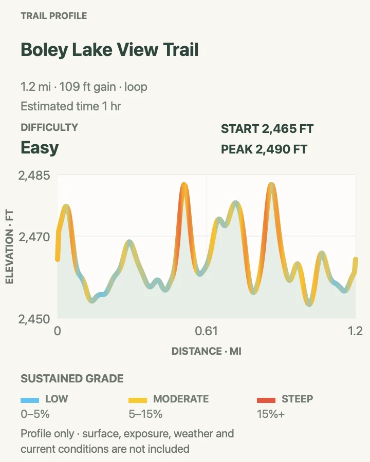
Boley Lake View Trail
- Distance
- About 1.2 miles around Boley Lake
- Elevation gain
- 110 feet
- Time
- 1 hr
- Difficulty
- Easy
- Route type
- loop
- Parking
- Park at the Boley Lake lot in Babcock State Park; this route is state-managed rather than an NPS trail.
- Best time
- A calm morning in spring, summer, or fall.
- Pets
- Check current Babcock State Park pet rules before the walk.
Boley Lake View is the deliberate outlier in this guide. It sits in Babcock State Park, within the larger New River Gorge travel area, and circles the lake on a mostly level line. It suits a recovery morning or a family outing better than the national park's steep gorge descents.
The reviewed track adds only modest climbing. A spur can connect toward the Glade Creek Grist Mill, but that extension is not included in the map or elevation figure here. Check the state park's current trail notice before setting out because flood damage has affected other Babcock trail connections.
What helps on this route
- Use the lake lot if the goal is the easy loop; the grist-mill approach adds a steeper spur.
- Keep this route separate from a Sandstone Falls day unless the driving route already passes Babcock.
Terrain and access: Mostly level lakeside path with short rolling sections, roots, damp ground, and wooded shoreline.

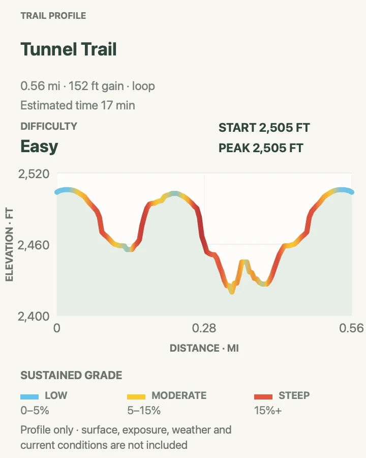
Tunnel Trail
- Distance
- About 0.6 mile as a reviewed loop
- Elevation gain
- 150 feet
- Time
- 17 min
- Difficulty
- Easy
- Route type
- loop
- Parking
- Use the Grandview day-use parking area and follow the posted trail map to the Tunnel Trail loop.
- Best time
- A dry morning or as a short addition to another Grandview walk.
- Pets
- Leashed pets are allowed; keep them close through narrow rock features.
Tunnel Trail is a small route with more texture than its mileage suggests. It winds through the Grandview woods and around the area's sandstone formations, gaining and losing roughly 150 feet before closing the loop.
This is useful when weather shortens a Grandview visit or when Castle Rock would be too rough. It is not an accessible path, and damp rock still deserves careful footing. Combine it with the Main Overlook for a compact introduction to the area.
What helps on this route
- Confirm the loop junction on the Grandview map before leaving the developed area.
- Do not enter narrow rock openings that are not part of the signed path.
Terrain and access: Short forest loop, rock features, roots, modest climbing, uneven tread, and damp stone after rain.

Official planning sources
Trail access and safety details were checked against these National Park Service pages. The maps and profiles use the reviewed route geometry stored with this guide.
- NPS: New River Gorge alerts and conditions
- NPS: Hiking areas, trail distances, and private-property reminder
- NPS: Hiking safety in New River Gorge
- NPS: Pet rules
- NPS: Fayetteville area trails
- NPS: Grandview area trails
- NPS: Glade Creek trails and waterfalls
- NPS: Sandstone Falls and Island Loop
- NPS: Visiting the Kaymoor mining site
- West Virginia State Parks: Babcock trail descriptions and current notice
Map data © OpenStreetMap contributors. Trail geometry and planning details include National Park Service public information.