12 Best Hikes in Death Valley National Park
Twelve Death Valley hikes for salt flats, badlands, slot canyons, mining history, waterfalls, and high-country relief, with reviewed maps, elevation profiles, and live park alerts.
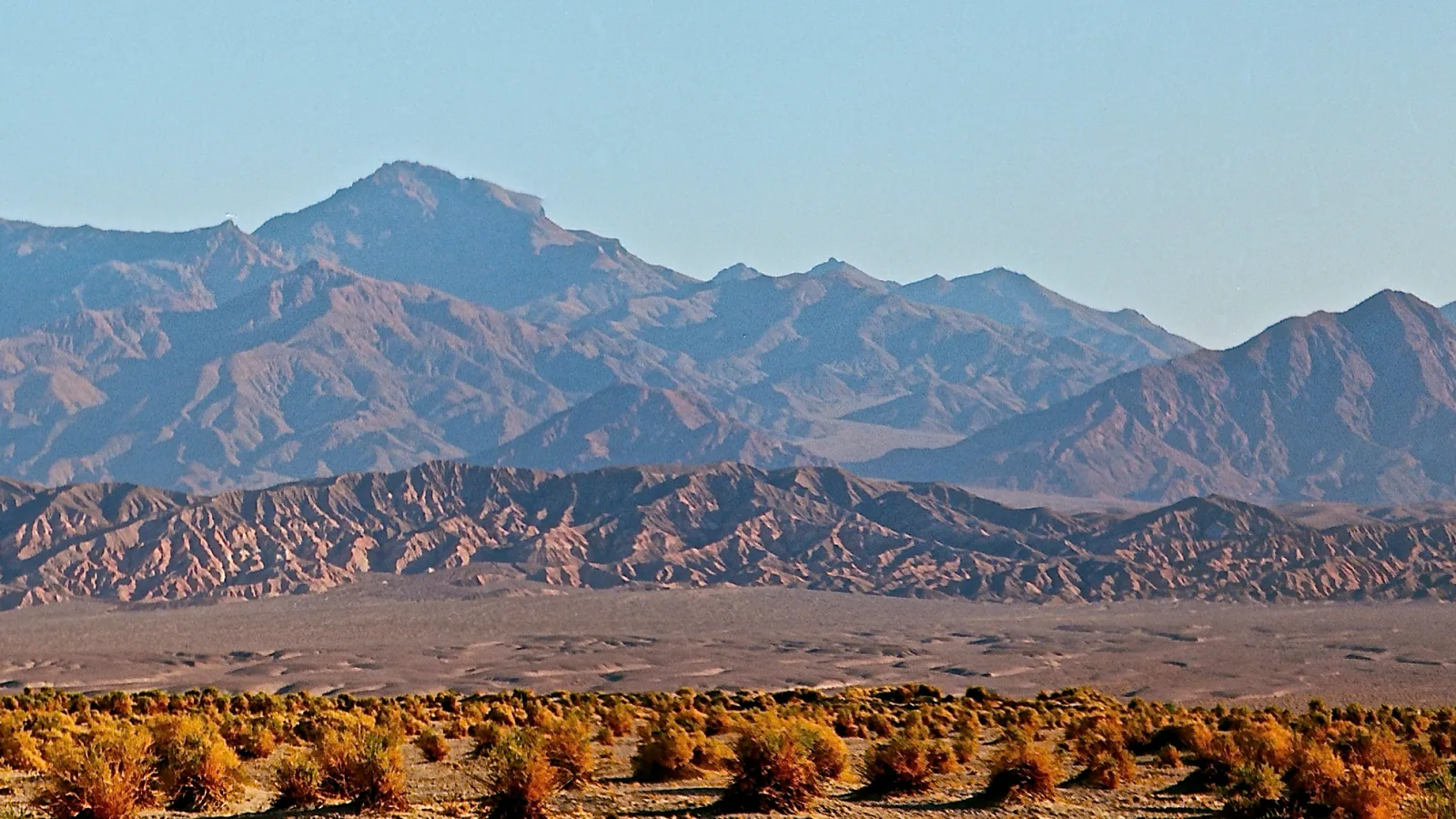
Death Valley hiking works best as a seasonal menu. A January day can favor Badwater and Golden Canyon; the same ground can be deadly in August. In summer, the sensible foot travel moves to high elevation, while the valley floor becomes a sequence of brief stops near an air-conditioned vehicle.
These twelve routes are not a longest-to-shortest or popularity ranking. They cover the salt basin, Furnace Creek history, the Golden Canyon badlands, southern slot canyons, the Titus mouth, Panamint Springs, and the Wildrose high country. Three routes share the Golden Canyon trail system, but each earns its place: a direct out-and-back, a compact loop from Zabriskie Point, and a longer circuit through Gower Gulch.
Flood damage still affects access. In August 2026, the Darwin Falls road remains washed out, so the recorded route begins from CA-190; Titus Canyon can close on short notice and is scheduled for a lengthy repair closure beginning October 1, 2026. Road status and flash-flood risk can change between breakfast and the trailhead. Check the live panel below before driving away from service.
What changes a hiking day here
Low country belongs to the cool season
The National Park Service recommends November through March for most valley hikes and advises against low-elevation hiking in summer. Heat can remain dangerous even in the 80s and 90s Fahrenheit. A predawn start is not permission to continue after the day turns hot.
Carry the water; do not count on finding it
Take at least two liters for a short winter hike and a gallon or more for longer warm-weather travel. Springs are rare and unreliable. Darwin Falls is a protected water source, not a place to swim, wash, or refill without treatment.
A canyon forecast is part of the route
Do not enter a canyon during rain or when storms threaten its drainage. Sidewinder, Fall, Titus, Golden, and Gower offer few easy exits once water and debris begin moving. Turn around before conditions deteriorate.
Road status decides the real mileage
A closed or damaged approach can add miles or remove a route from the day entirely. Download the park road map before losing reception, carry a full-size spare on backcountry roads, and never drive around a closure into the desert.
| Trail | Distance | Time | Difficulty | Best for |
|---|---|---|---|---|
| Badwater Basin Salt Flats | 1.9 mi | 33 min | Easy | Walking onto the lowest exposed ground in North America |
| Harmony Borax Works | 0.4 mi | 9 min | Easy | A short accessible history walk |
| Dante's View Ridge Walk | 0.9 mi | 29 min | Moderate | A high overlook with very little walking |
| Artist's Drive Hill | 0.4 mi | 1 hr | Moderate | A quick climb above the painted hills |
| Golden Canyon to Red Cathedral | 3 mi | 1 hr 52 min | Moderate | A direct walk into the park's most colorful canyon walls |
| Badlands Loop from Zabriskie Point | 2.6 mi | 1 hr 10 min | Moderate | A compact loop through the folds below Zabriskie Point |
| Gower Gulch Loop | 4.3 mi | Varies | Moderate | A half-day badlands circuit with mining traces and canyon narrows |
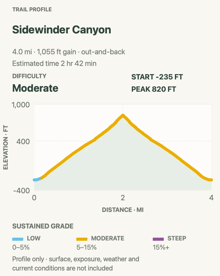
| Sidewinder Canyon | 4.1 mi | 2 hr 42 min | Moderate | Demanding slot-canyon exploration for self-reliant hikers |
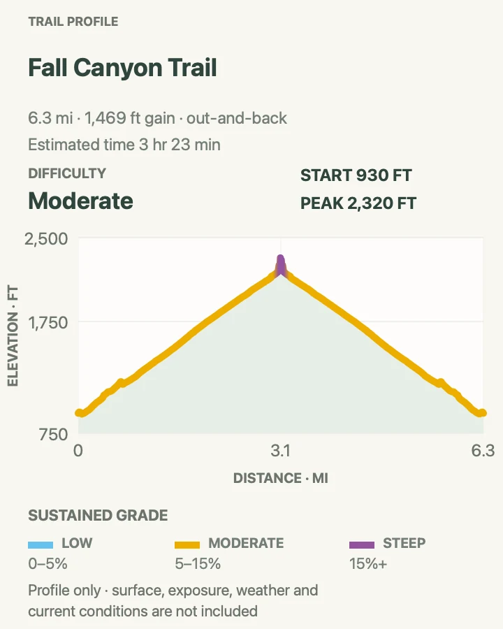
| Fall Canyon | 6.5 mi | 3 hr 23 min | Moderate | A long limestone canyon without technical slot moves |
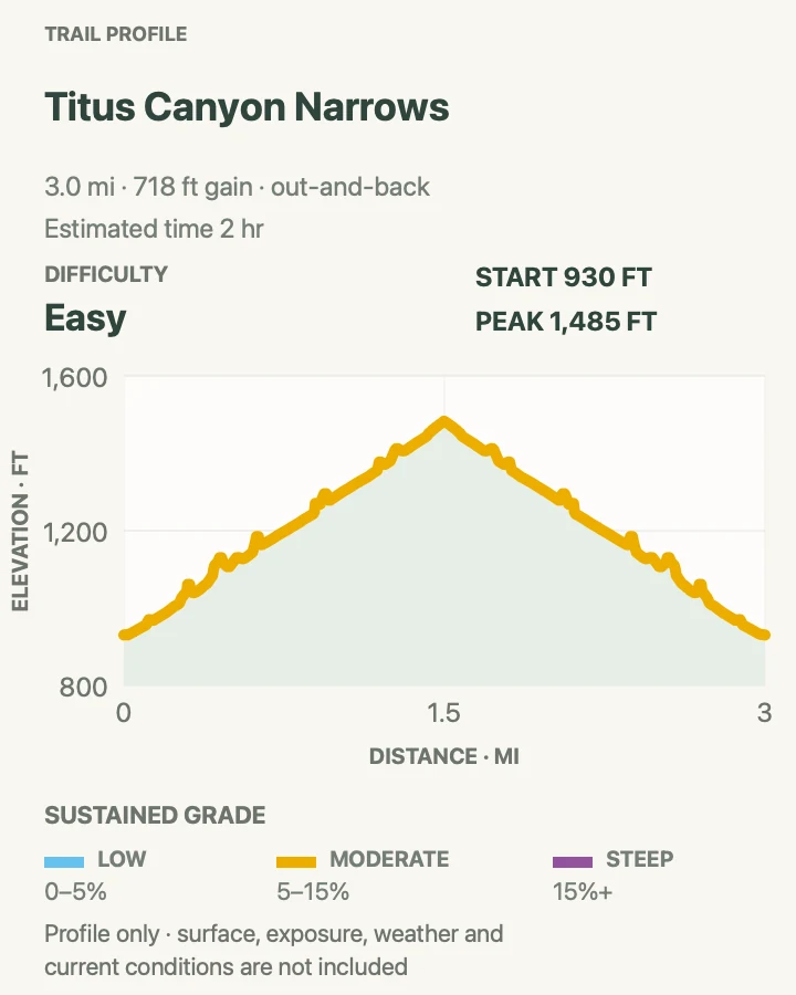
| Titus Canyon Narrows | 3.1 mi | 2 hr | Easy | A short walk between the towering walls at the canyon mouth |
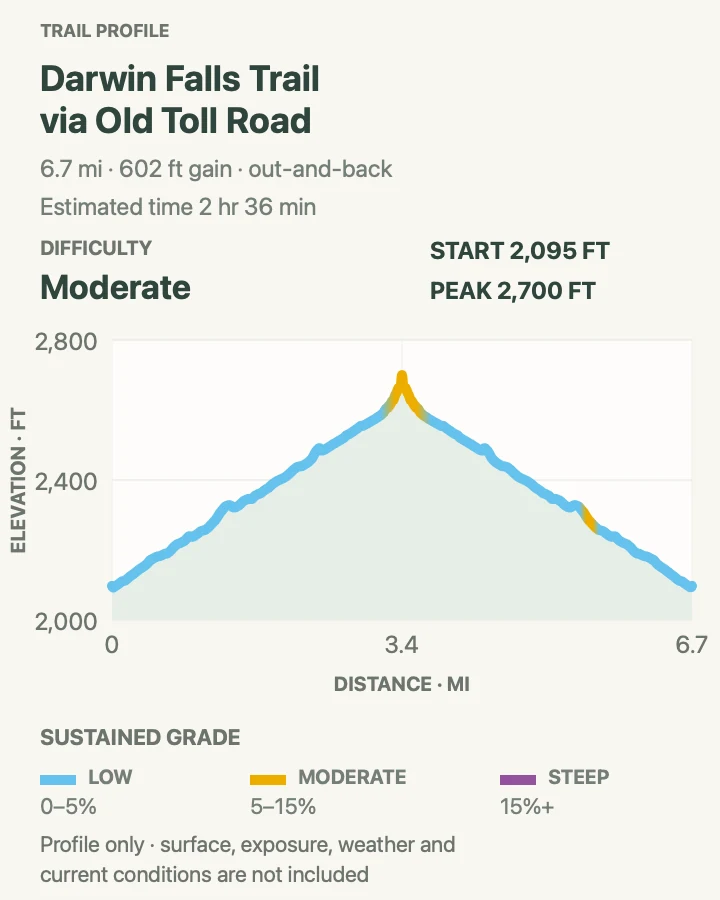
| Darwin Falls via the Old Toll Road | 6.7 mi | 2 hr 36 min | Moderate | An improbable desert waterfall reached by a longer walk-in |
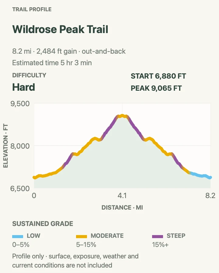
| Wildrose Peak | 8.3 mi | 5 hr 3 min | Hard | A real summit hike above the valley heat |
Badwater Basin Salt Flats
- Distance
- 1.9 mi
- Elevation gain
- 10 feet
- Time
- 33 min
- Difficulty
- Easy
- Route type
- out-and-back
- Parking
- Use the signed Badwater Basin lot on Badwater Road. Park only on durable, designated surfaces.
- Best time
- Cool-season sunrise, when the basin is quiet and the salt polygons catch low light.
- Pets
- Pets are not allowed on park trails. Trained service animals are allowed.
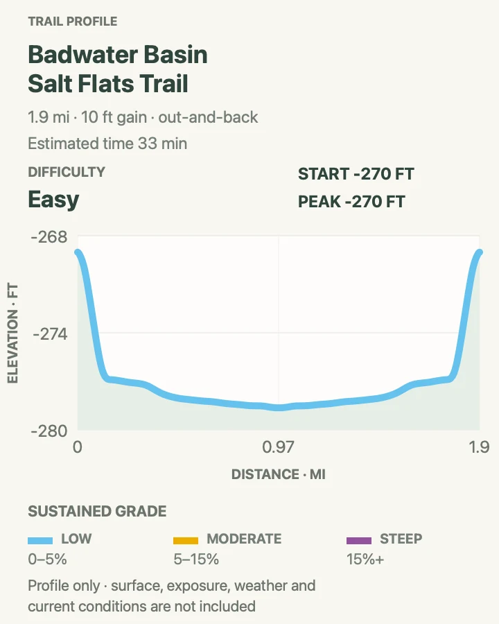
A boardwalk reaches the edge of the salt, then footprints fan onto the white basin. The mapped out-and-back continues far enough to leave the roadside bustle and see the polygon texture without pretending the whole playa is a maintained trail.
The flat grade disguises the exposure. There is no shade, the return looks shorter than it is, and wet salt can conceal soft mud. Stay on the established walking line and turn back before heat or footing becomes a problem.
What helps on this route
- Look back toward the parking area occasionally; the cars shrink quickly against the mountain wall.
- Do not collect salt or carve messages into the crust.
Terrain and access: Boardwalk, hard salt crust, occasional soft or wet patches, no shade, and a visually open route across the basin.

Harmony Borax Works
- Distance
- 0.4 mi
- Elevation gain
- 30 feet
- Time
- 9 min
- Difficulty
- Easy
- Route type
- loop
- Parking
- Use the paved Harmony Borax Works lot about one mile west of Furnace Creek on CA-190.
- Best time
- Early morning, evening, or after dark for the open sky; avoid the midday summer heat.
- Pets
- Pets are not allowed on park trails. Trained service animals are allowed.
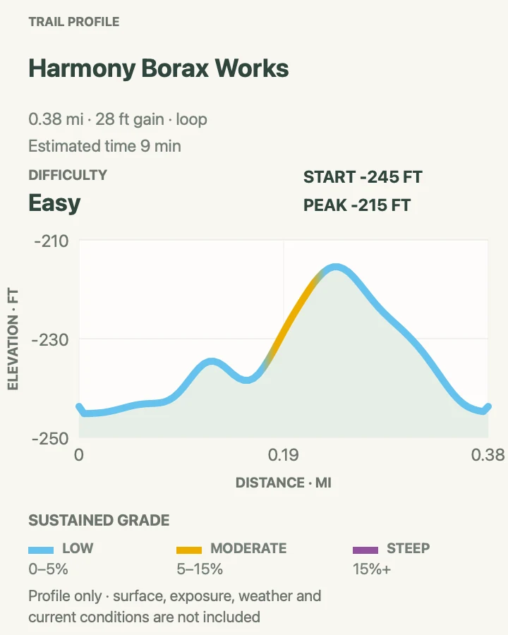
This compact paved loop passes the remains of the borax plant and a twenty-mule-team wagon. Interpretive panels explain work and life at Harmony without turning the stop into a museum-length commitment.
It is a useful first walk after a long drive and a fair option for mixed-ability groups. The exposed pavement still becomes punishing in hot weather, so short mileage should not be mistaken for low heat risk.
What helps on this route
- Pair it with the Furnace Creek Visitor Center rather than squeezing in another low-elevation hike at noon.
- Bring a red-light flashlight if returning for stars.
Terrain and access: Paved interpretive loop, gentle grade, historic machinery, complete sun exposure, and no restroom at the site.

Dante's View Ridge Walk
- Distance
- 0.9 mi
- Elevation gain
- 290 feet
- Time
- 29 min
- Difficulty
- Moderate
- Route type
- out-and-back
- Parking
- Park at the end of Dante's View Road; vehicles longer than the posted limit must stop below the final climb.
- Best time
- Sunrise or a clear cool afternoon, when haze is low and wind is manageable.
- Pets
- Pets are not allowed on park trails. Trained service animals are allowed.
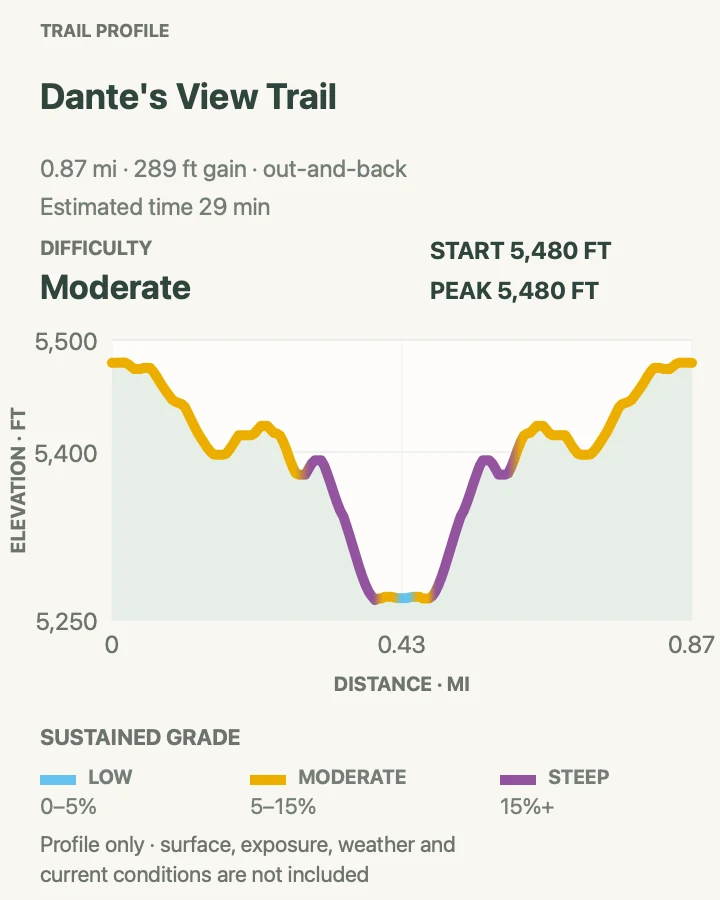
The short ridge path extends the famous overlook northward, with Badwater far below and the Panamint Range across the basin. Even a few hundred yards separates the walk from the paved viewpoint crowd.
Elevation makes this cooler than the valley floor but also windier. The ridge edge is loose in places, and winter storms can leave snow or ice. Stop where footing or visibility stops feeling certain.
What helps on this route
- Carry a layer even when Furnace Creek is warm.
- Save the unprotected ridge for another day during strong wind or lightning.
Terrain and access: High desert ridge, loose rock, short climbs, abrupt slopes, wind exposure, and possible winter snow or ice.

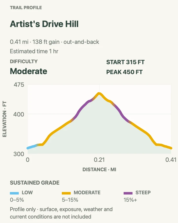
Artist's Drive Hill
- Distance
- 0.4 mi
- Elevation gain
- 140 feet
- Time
- 1 hr
- Difficulty
- Moderate
- Route type
- out-and-back
- Parking
- Use a legal pullout on the one-way Artist's Drive loop without blocking traffic or fragile shoulders.
- Best time
- Late afternoon in cool weather, when the mineral colors deepen.
- Pets
- Pets are not allowed on park trails. Trained service animals are allowed.
This short path climbs from the scenic drive onto a low ridge where folded volcanic deposits show more shape than they do through a windshield. It is a walk for color and perspective, not mileage.
The approach and exact pullout are easy to miss on the one-way road. Do not reverse, improvise parking, or step onto closed restoration ground. Loose gravel makes the brief descent the trickier half.
What helps on this route
- Complete the full one-way drive after the walk; do not try to backtrack for a missed turnout.
- Use sun protection even for this short stop.
Terrain and access: Loose desert gravel, low exposed ridge, short steep pitch, roadside access, and no constructed shade.

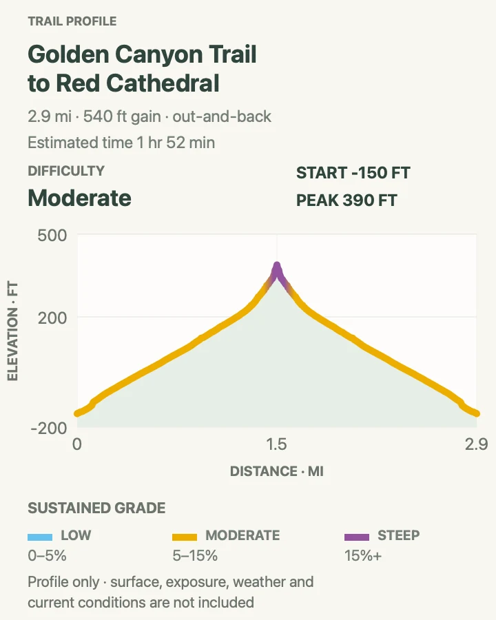
Golden Canyon to Red Cathedral
- Distance
- 3 mi
- Elevation gain
- 540 feet
- Time
- 1 hr 52 min
- Difficulty
- Moderate
- Route type
- out-and-back
- Parking
- Use the paved Golden Canyon trailhead lot two miles south of CA-190 on Badwater Road.
- Best time
- Cool-season morning before tour traffic and sun fill the canyon.
- Pets
- Pets are not allowed on park trails. Trained service animals are allowed.
Golden Canyon narrows between fluted walls before a spur climbs into the red rock amphitheater beneath Red Cathedral. This out-and-back gives a strong sample of the badlands without committing to the full Gower circuit.
The Red Cathedral spur is steeper and rougher than the main canyon, with gravel, sand, and rock steps. Heat reflects from the walls. If the return canyon is already baking, the turnaround came too late.
What helps on this route
- Carry the official Golden Canyon map; several junctions lead into longer routes.
- Skip the spur when wet rock, thunderstorms, or heat make the confined finish a poor choice.
Terrain and access: Gravel wash, narrow canyon, loose sand, natural rock steps, steep final spur, and fully exposed badlands.

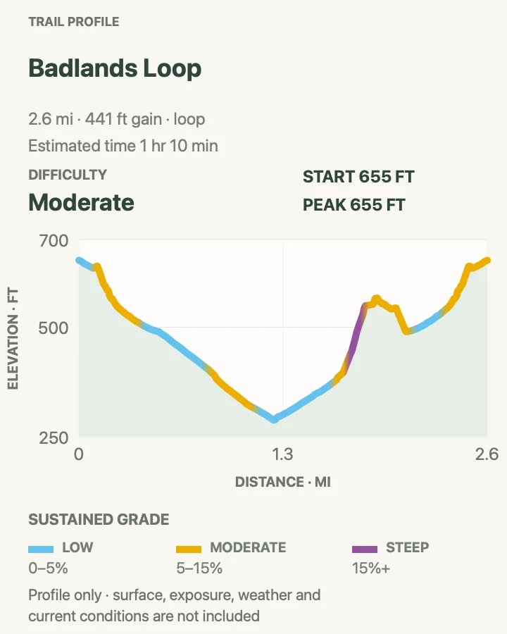
Badlands Loop from Zabriskie Point
- Distance
- 2.6 mi
- Elevation gain
- 440 feet
- Time
- 1 hr 10 min
- Difficulty
- Moderate
- Route type
- loop
- Parking
- Start at the paved Zabriskie Point lot on CA-190, where vault toilets are available.
- Best time
- Just after sunrise in the cool season, once viewpoint photographers begin to disperse.
- Pets
- Pets are not allowed on park trails. Trained service animals are allowed.
From one of the park's busiest overlooks, the trail drops into a quiet maze of old lakebed. Repeated drainage turns and short climbs make the interior feel much larger than the 2.7-mile circuit suggests.
Small signs mark major junctions, but the folds can look alike. Photograph the map at the trailhead and watch for the correct return climb rather than following whichever boot track looks busiest.
What helps on this route
- Expect the final climb back to Zabriskie Point to feel hottest and steepest.
- Do not add Red Cathedral on impulse unless water, time, and temperature support it.
Terrain and access: Eroded badlands, compacted wash, short steep climbs, confusing drainages, loose gravel, and no shade.

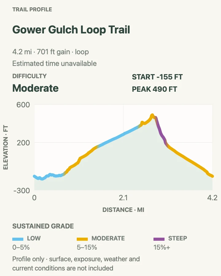
Gower Gulch Loop
- Distance
- 4.3 mi
- Elevation gain
- 700 feet
- Time
- Varies
- Difficulty
- Moderate
- Route type
- loop
- Parking
- Begin at the Golden Canyon lot; the Zabriskie start creates a different and longer combination.
- Best time
- A cool, settled winter morning with four unhurried hours available.
- Pets
- Pets are not allowed on park trails. Trained service animals are allowed.
The loop climbs Golden Canyon, crosses the badlands, and descends Gower Gulch toward the valley. It feels more varied than its mileage: broad mineral hills give way to a wash, old workings, and a tight canyon exit.
A dryfall near the mouth is bypassed on the north side, where short ledges require deliberate hands-and-feet movement. This is not the place to improvise after rain. Carry the route sheet and retreat if the bypass is wet or unclear.
What helps on this route
- Travel counterclockwise if you prefer to descend the long gulch after the morning climb.
- Leave mining structures and tailings untouched; unstable openings are not shortcuts.
Terrain and access: Canyon wash, badlands, old mining ground, loose gravel, short rock ledges, dryfall bypass, and sustained sun exposure.

Sidewinder Canyon
- Distance
- 4.1 mi
- Elevation gain
- 1,050 feet
- Time
- 2 hr 42 min
- Difficulty
- Moderate
- Route type
- out-and-back
- Parking
- Take the unmarked gravel spur from Badwater Road between mile markers 31 and 32; use the open gravel parking area shared with Willow Canyon.
- Best time
- A cool winter day with no rain in the forecast or upstream drainage.
- Pets
- Pets are not allowed on park trails. Trained service animals are allowed.
Sidewinder begins with a route-finding walk across an alluvial fan, then enters a broad canyon with three tighter side slots. The best sections are earned rather than handed over by a sign or boardwalk.
The official description is blunt: some passages require climbing ledges higher than six feet and squeezing or crawling through gaps about eighteen inches wide. The map library's 4.1-mile trace is a conservative line; the park describes a five-mile, roughly six-hour outing. Turn around before any move you cannot reverse.
What helps on this route
- Carry the official GPX plus a paper map and compass; there is no route signage.
- Do not enter if rain is possible, and do not count on a phone signal for rescue.
Terrain and access: Trail-less alluvial fan, rocky canyon floor, tight slots, high ledges, scrambling, squeezing, and serious flash-flood exposure.

Fall Canyon
- Distance
- 6.5 mi
- Elevation gain
- 1,470 feet
- Time
- 3 hr 23 min
- Difficulty
- Moderate
- Route type
- out-and-back
- Parking
- Use the west-side Titus Canyon and Fall Canyon access area; confirm the current road status before leaving pavement.
- Best time
- A calm cool-season morning, avoiding rain anywhere over the Grapevine Mountains.
- Pets
- Pets are not allowed on park trails. Trained service animals are allowed.
Fall Canyon works steadily into the Grapevine Mountains between tall walls and polished narrows. The walking is less acrobatic than Sidewinder, making it the better canyon choice for hikers who want distance and geology without squeezing through slots.
A dryfall blocks easy progress farther up canyon. The day hike is an out-and-back, so decide a turnaround while the return still fits daylight and temperature. Road repairs or a Titus closure can change the trailhead approach.
What helps on this route
- Mark the canyon-mouth exit on the way in; broad wash junctions look different on the return.
- Treat every rain forecast as a reason to choose an open ridge or developed stop instead.
Terrain and access: Rocky wash, deep limestone canyon, gradual ascent, polished narrows, dryfall turnaround, and no reliable water or shade.

Titus Canyon Narrows
- Distance
- 3.1 mi
- Elevation gain
- 720 feet
- Time
- 2 hr
- Difficulty
- Easy
- Route type
- out-and-back
- Parking
- Approach the short two-way west end from Scotty's Castle Road only when the park lists it open; park without narrowing the road.
- Best time
- A cool weekday morning before vehicle traffic builds, with a dry forecast.
- Pets
- Pets are not allowed on park trails. Trained service animals are allowed.
Walking the west end turns the grand finale of Titus Canyon into a manageable out-and-back. The walls close tightly around the old road, so the scale arrives quickly even without driving the rough one-way route from Nevada.
The route is still a road when open. Face traffic, move aside early, and never assume a closure applies only to cars. The park expects another long construction closure beginning October 1, 2026; check the live status rather than relying on this guide.
What helps on this route
- Choose Fall Canyon from the same area if vehicle traffic makes the narrows unpleasant.
- Do not enter during rain or when debris and fresh water marks show recent flooding.
Terrain and access: Graded dirt road, gravel, towering narrows, mixed vehicle and foot traffic, no shade, and flash-flood exposure.

Darwin Falls via the Old Toll Road
- Distance
- 6.7 mi
- Elevation gain
- 600 feet
- Time
- 2 hr 36 min
- Difficulty
- Moderate
- Route type
- out-and-back
- Parking
- Park completely off CA-190 where the park permits shoulder parking; the damaged Darwin Falls road is closed and should not be driven.
- Best time
- A cool morning in fall through spring, before the exposed road walk heats up.
- Pets
- Pets are not allowed on park trails. Trained service animals are allowed.
Floods removed sections of the old approach road, adding several exposed miles before the greener canyon begins. The reward is a spring-fed corridor and waterfall that feel out of place beside Panamint Valley.
The seven-mile version is not the old short family stroll. Road damage is the reason for the distance, and loose gravel plus heat make the approach tiring. Keep out of the water, protect the spring, and turn back if the legal parking or route is unclear.
What helps on this route
- Download the current closure notice before Panamint Springs; the road is expected to remain closed into 2027.
- Carry all drinking water despite the visible stream.
Terrain and access: Long exposed damaged-road approach, gravel and wash crossings, greener canyon tread, rock near the falls, and no legal vehicle access on the closed road.

Wildrose Peak
- Distance
- 8.3 mi
- Elevation gain
- 2,480 feet
- Time
- 5 hr 3 min
- Difficulty
- Hard
- Route type
- out-and-back
- Parking
- Follow Emigrant Canyon Road past Wildrose Campground to the Charcoal Kilns when open; the final two miles are maintained gravel and vehicles are limited to 25 feet.
- Best time
- Summer morning for cooler high-country hiking, or a snow-free fall day with clear views.
- Pets
- Pets are not allowed on park trails. Trained service animals are allowed.
Wildrose climbs from the charcoal kilns through pinyon-juniper woodland to a broad summit over Death Valley and Panamint Valley. It is the substantial mountain day in this collection and one of the few sensible summer options when lower elevations are dangerously hot.
High elevation swaps heat for wind, winter snow, and a long climb. The trail gains roughly 2,200 feet; the map library's trace is 8.3 miles while the current park directory rounds the route to about eight. Carry layers and abandon the ridge for thunder, hard ice, or poor visibility.
What helps on this route
- Check both Emigrant Canyon and Wildrose road status before committing to the drive.
- In winter and spring, snow may require mountaineering equipment and experience.
Terrain and access: Maintained mountain trail, steady climb, pinyon-juniper woodland, exposed summit ridge, wind, and possible snow or ice.

Official planning sources
Trail access and safety details were checked against these National Park Service pages. The maps and profiles use the reviewed route geometry stored with this guide.
Map data © OpenStreetMap contributors. Trail geometry and planning details include National Park Service public information.