21 Best Hikes in Saguaro National Park
Twenty-one distinct Saguaro hikes across both districts, with custom terrain maps, measured elevation profiles, trailhead notes, and live park conditions.
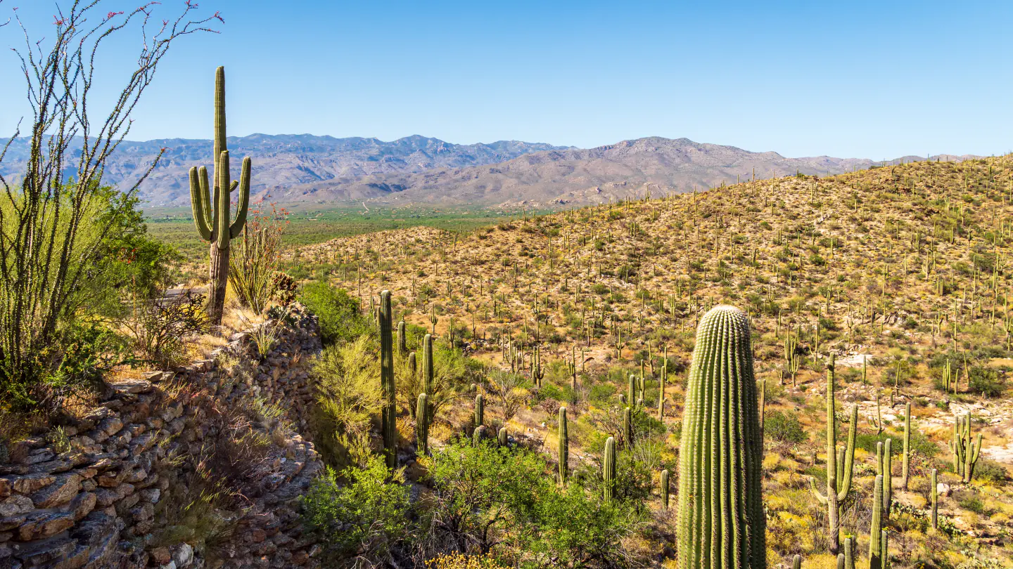
Saguaro National Park is split by Tucson. The Tucson Mountain District protects the lower, drier west side; the Rincon Mountain District rises from cactus forest toward pine country on the east. There is no road through the park between them, so choosing a district is the first trail decision.
These twenty-one hikes cover short paved nature trails, one-way trail sections, moderate desert circuits, historic mine and homestead routes, and two serious mountain objectives. Published distance appears on each card. Elevation gain is measured from the same preserved geometry used for its map, and every one-way route is identified so its return or shuttle is not hidden.
Planning information was checked on September 1, 2026. Desert heat, monsoon runoff, wildfire operations, unpaved-road conditions, and temporary trail work can change access quickly. Read the live condition and weather panels, follow gates and posted signs, and treat current ranger direction as controlling over any route shown here.
Live park weather
Saguaro National Park
Rincon Mountain Visitor Center, east district
Loading the latest conditions and alerts…
What changes a hiking day here
Choose one district for the hiking day
The west district is reached from Kinney Road and contains the King Canyon, Sendero Esperanza, Signal Hill, Cam-Boh, and Belmont route groups. The east district uses Old Spanish Trail, Broadway Boulevard, Speedway Boulevard, and the Cactus Forest Loop Drive. Crossing Tucson between districts consumes substantial time, and the park has no internal connector road.
Move the start earlier as temperatures rise
Most routes are exposed Sonoran Desert walks with little dependable shade. Carry all needed water, use sun protection, and turn around before heat stress develops. A mild Tucson forecast does not remove the risk on a long climb or an afternoon return across open ground.
Keep out of washes during storms
Summer monsoon cells can produce lightning and fast runoff far from the visible rain shaft. Do not enter a wash when storms are building, never cross moving water, and leave ridges and summits before thunder reaches the area. Soft or damaged roads may also change which trailhead is reachable.
Read point-to-point mileage literally
Cactus Forest North, Cactus Forest Trail, Cactus Forest South, Sendero Esperanza, Gould Mine, King Canyon, Mica View, Pink Hill, and Three Tank are mapped as one-way sections. Arrange a legal pickup or budget the time, water, and distance to retrace. Do not assume the comparison-table mileage includes the return.
Keep pets to the three legal trail choices
NPS identifies Mica View Trail, Desert Ecology Trail, and Desert Discovery Trail as the only pet-friendly trails in this guide. Use a leash no longer than six feet, carry water for the animal, and protect paws from hot pavement and cactus. Pets are prohibited on the other selected trails.
Respect mines, petroglyphs, and desert life
Stay outside mine openings and shafts, leave historic material where it lies, and never touch or mark petroglyphs. Step around cryptobiotic soil and plants, give rattlesnakes and other wildlife room, and use established tread rather than cutting switchbacks or widening a wash route.
| Trail | Distance | Time | Difficulty | Best for |
|---|---|---|---|---|
| Cactus Wren Loop | 4.3 miles | Allow 2 to 3 hours | Moderate | Signal Hill petroglyphs and a quieter west-side circuit |
| Desert Discovery Trail | 0.4 mile | Allow 20 to 40 minutes | Easy | An accessible introduction to Sonoran Desert ecology |
| Wild Dog Trail via Valley View Trail | About 2.0 miles round trip | Allow 1 to 1.5 hours | Moderate | A compact west-side trail between loop-drive roads |
| Sendero Esperanza Trail | 3.1 miles one way | Allow 2 to 3 hours one way | Moderate | A ridge crossing through the Tucson Mountains |
| Sendero Esperanza Trail to Wasson Peak | 8.0 miles round trip | Allow 4.5 to 6 hours | Strenuous | Wasson Peak from the quieter northwest approach |
| Gould Mine Trail | 1.1 miles one way | Allow 45 to 75 minutes one way | Moderate | Mining history and a link into the King Canyon network |
| King Canyon Trail | 0.8 mile one way | Allow 35 to 60 minutes one way | Moderate | A direct old-road approach into the west-side trail network |
| Cam Boh Loop | 4.0 miles | Allow 2 to 3 hours | Moderate | A low-use circuit with three contrasting trail sections |
| Belmont Loop | 3.7 miles | Allow 2 to 3 hours | Moderate | A quiet circuit to an old windmill |
| Cactus Forest South | 0.9 mile one way | Allow 35 to 60 minutes one way | Moderate | A quieter southern cactus-forest section |
| Cactus Forest Trail | 2.5 miles one way | Allow 1.5 to 2.5 hours one way | Moderate | A longer traverse through the east district's namesake cactus forest |
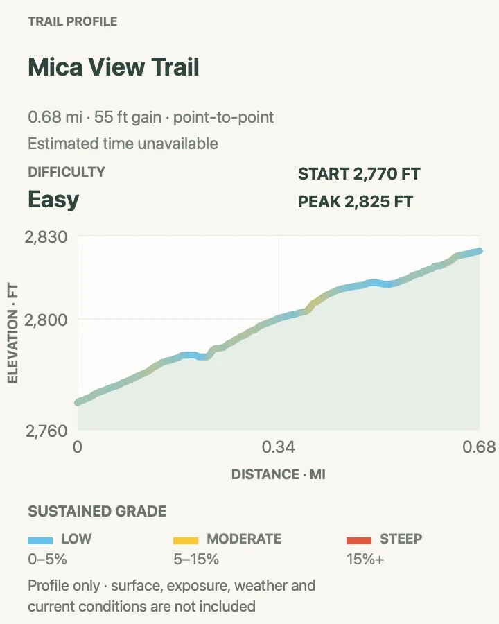
| Mica View Trail | 0.7 mile one way | Allow 25 to 45 minutes one way | Easy | A paved accessible trail through mature saguaros |
| Freeman Homestead Trail | 0.9 mile | Allow 45 to 75 minutes | Easy | Homestead history, wash habitat, and a short east-side loop |
| Pink Hill Trail | 1.5 miles one way | Allow 1 to 1.5 hours one way | Moderate | A compact hilltop viewpoint reached through cactus forest |
| Desert Ecology Trail | 0.25 mile | Allow 15 to 30 minutes | Easy | An accessible east-district ecology walk |
| Tanque Verde Peak via Tanque Verde Ridge Trail | 17.4 miles round trip | Allow a full day | Strenuous | A long climb from cactus forest toward high-country terrain |
| Cactus Forest North | 1.7 miles one way | Allow 1 to 1.5 hours one way | Easy | A relatively gentle traverse between the loop road and Broadway |
| Loma Verde Loop | 3.8 miles | Allow 2 to 3 hours | Moderate | A moderate east-side loop through cactus forest and washes |
| Hope Camp and Ridge View Trail | 2.0 miles round trip | Allow 1 to 1.5 hours | Moderate | A short southern foothills walk toward Rincon views |
| Garwood Dam and Wildhorse Tank | 6.4 miles | Allow 4 to 5.5 hours | Strenuous | Historic Garwood Dam, Little Wildhorse Tank, and a full foothills circuit |
| Three Tank Trail | 2.2 miles one way | Allow 1.5 to 2.5 hours one way | Moderate | A quieter connector across the Rincon foothill trail network |
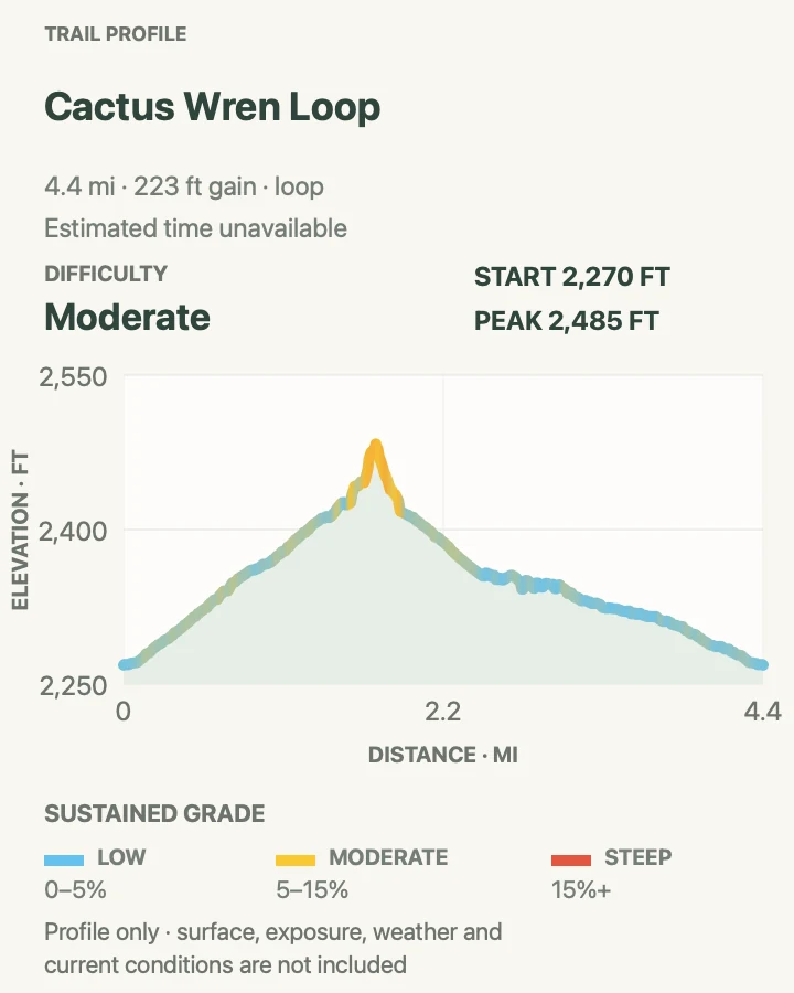
Cactus Wren Loop
- Distance
- 4.3 miles
- Elevation gain
- 220 feet
- Time
- Allow 2 to 3 hours
- Difficulty
- Moderate
- Route type
- Loop
- Parking
- Use the Cactus Wren access point, an unmarked dirt pullout with a broad shoulder near Picture Rocks; confirm roadside conditions before leaving the vehicle.
- Best time
- A cool morning when Signal Hill and the return are still comfortable.
- Pets
- Pets are prohibited on this trail.
Cactus Wren links the Cactus Wren, Stock Bypass, and Manville trails through the relatively open country near Picture Rocks. The circuit reaches Signal Hill, where a signed trail interprets petroglyphs made by ancestral desert peoples. Stay on the developed viewing route and never touch the rock art.
The opening is sandy and fairly level, while the Signal Hill side adds uneven rock, steps, and a short steep pitch. NPS measured a maximum grade near thirty percent on its surveyed line. The mixture of wash travel and firmer tread makes the loop more demanding than its modest overall elevation change suggests.
What helps on this route
- Save the junction map before leaving service; three named trails form the loop.
- Give horses room and avoid standing in the soft edge of the tread when a group passes.
Terrain and access: Firm desert tread mixed with soft sand and washes, plus rocky steps and one short steep section near Signal Hill.

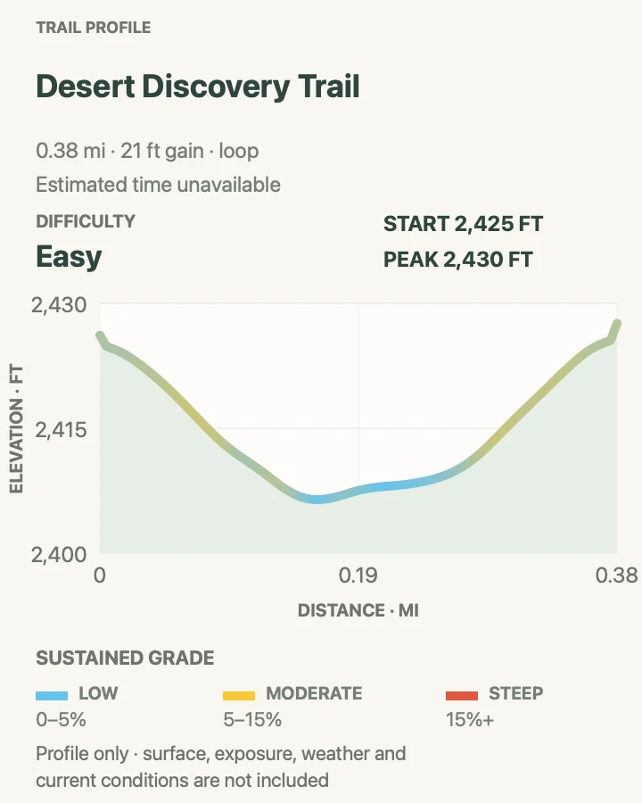
Desert Discovery Trail
- Distance
- 0.4 mile
- Elevation gain
- 20 feet
- Time
- Allow 20 to 40 minutes
- Difficulty
- Easy
- Route type
- Loop
- Parking
- Park at the signed Desert Discovery Trail lot on Kinney Road in the Tucson Mountain District.
- Best time
- Any cooler part of the day; shaded ramadas make pauses easier.
- Pets
- Leashed pets are permitted; use a leash no longer than six feet and carry water.
Desert Discovery is the west district's paved interpretive loop. Signs introduce common Sonoran Desert plants and ecological relationships, while frequent saguaros make the short circuit useful before a longer route elsewhere in the district.
NPS describes the trail as wide, nearly level, and constructed to accessibility standards, with several shaded ramadas. The pavement can still become dangerously hot, so short distance should not be mistaken for heat protection.
What helps on this route
- Read the interpretive panels before visiting an unsigned backcountry trail.
- Check pavement temperature before bringing a dog.
Terrain and access: Wide paved trail with gentle grades, firm footing, and shade structures.

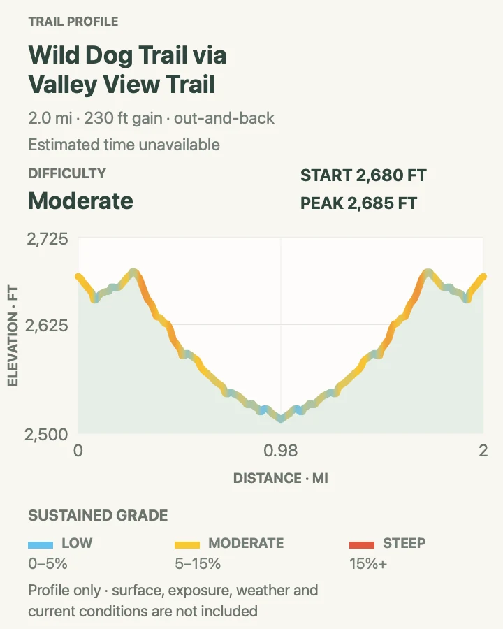
Wild Dog Trail via Valley View Trail
- Distance
- About 2.0 miles round trip
- Elevation gain
- 230 feet
- Time
- Allow 1 to 1.5 hours
- Difficulty
- Moderate
- Route type
- Out and back
- Parking
- Begin from the Valley View access on Hohokam Road and follow Valley View to the signed Wild Dog junction; obey the one-way road pattern.
- Best time
- Early morning before the open Bajada country heats up.
- Pets
- Pets are prohibited on this trail.
The mapped outing uses the short Valley View approach, follows Wild Dog north to the Golden Gate Road and Signal Hill junction, then retraces the same line. That return produces a complete hike from a legal road access point instead of treating the route as an unexplained shuttle.
The official hiking page also describes a point-to-point pickup option and notes that continuing to Signal Hill picnic ground adds road mileage. This card does not include that extension. Keep the turn at Valley View clear on the return, when adjacent washes can make an unsigned shortcut look convincing.
What helps on this route
- Do not continue toward Signal Hill unless the extra road distance is part of the plan.
- Use the named Valley View junction for both outbound and return legs.
Terrain and access: Narrow desert path with sandy stretches, low rolling relief, and full exposure.

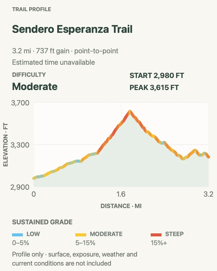
Sendero Esperanza Trail
- Distance
- 3.1 miles one way
- Elevation gain
- 740 feet
- Time
- Allow 2 to 3 hours one way
- Difficulty
- Moderate
- Route type
- Point to point
- Parking
- Start at the Sendero Esperanza trailhead on unpaved Golden Gate Road; verify road condition and arrange the return before hiking through.
- Best time
- A cool clear morning with enough daylight for the return plan.
- Pets
- Pets are prohibited on this trail.
Sendero Esperanza begins broadly in cactus forest, climbs a rocky section to a ridge, and drops toward the King Canyon network. The change from open desert floor to the ridge is the defining part of this one-way section, with views across the Tucson Mountains on both sides.
NPS notes rocky tread, several short staircases, a notable rut, and a steep winding section near King Canyon Wash. The trail meets several other routes, so the mapped point-to-point line should be saved before departure. Retracing doubles both distance and the ridge work.
What helps on this route
- Confirm Golden Gate Road is passable for the vehicle before relying on that trailhead.
- At each junction, match the sign to the saved route rather than following the broadest tread.
Terrain and access: Sandy lower trail, rocky ridge grades, steps, loose stone, and a steeper wash-side section.

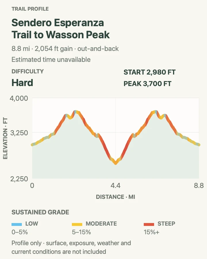
Sendero Esperanza Trail to Wasson Peak
- Distance
- 8.0 miles round trip
- Elevation gain
- 2,050 feet
- Time
- Allow 4.5 to 6 hours
- Difficulty
- Strenuous
- Route type
- Out and back
- Parking
- Use the Sendero Esperanza trailhead on Golden Gate Road after confirming the unpaved approach is open and suitable for the vehicle.
- Best time
- A cool-season start near sunrise, with no thunderstorm risk.
- Pets
- Pets are prohibited on this trail.
This summit outing follows Sendero Esperanza to the ridge and continues to Wasson Peak, the highest point in the Tucson Mountains. The route moves beyond the moderate point-to-point section into a longer climb where exposure, heat, and water management matter more than any single steep pitch.
NPS publishes an eight-mile round trip with about 1,600 feet of elevation change for this approach. The shared lower corridor is intentional: the summit continuation reaches a distinct major destination, while the standalone Sendero entry documents the official trail section and its through-hike logistics.
What helps on this route
- Carry the full water supply from the vehicle; no route water is dependable or safe untreated.
- Leave the ridge immediately when thunderstorms build and turn around for worsening heat.
Terrain and access: Exposed desert climb with sandy approaches, rocky ridge tread, sustained elevation gain, and no reliable shade.

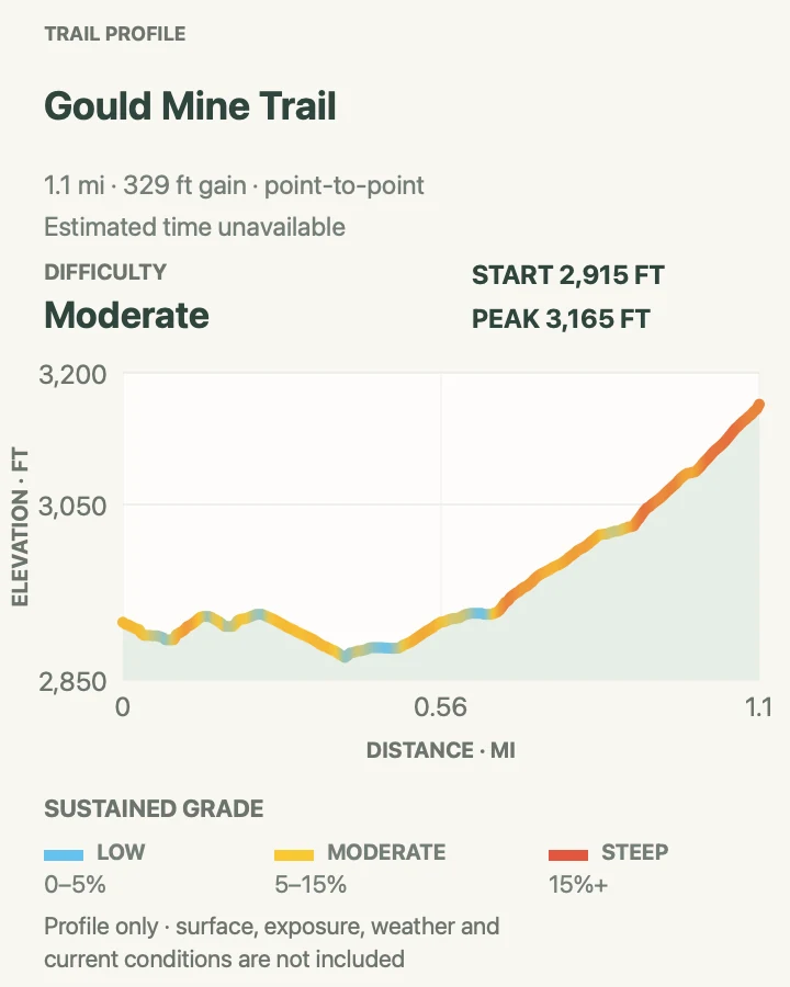
Gould Mine Trail
- Distance
- 1.1 miles one way
- Elevation gain
- 330 feet
- Time
- Allow 45 to 75 minutes one way
- Difficulty
- Moderate
- Route type
- Point to point
- Parking
- Start at King Canyon Trailhead on Pima County's Tucson Mountain Park land just outside the national park boundary.
- Best time
- A cool morning when mine-area rock and the return remain shaded where possible.
- Pets
- Pets are prohibited on this trail.
Gould Mine follows an old road toward a historic copper-mining site with colorful tailings, cabin foundations, and scattered workings. Observe every structure from stable ground and stay out of openings. Historic debris belongs in place and can have sharp or unstable edges.
The trail crosses a major wash and then uses firm soil, loose gravel, and short sandy patches. This card preserves the official one-way section instead of silently turning it into the popular King Canyon combination. If returning to the same car, double the mileage and allow extra time at the wash junction.
What helps on this route
- Stay out of shafts and openings even when an old track appears to continue inside.
- Look back at the wash crossing so the return direction is obvious.
Terrain and access: Old road grade, loose gravel, one significant wash crossing, and exposed mining ground.

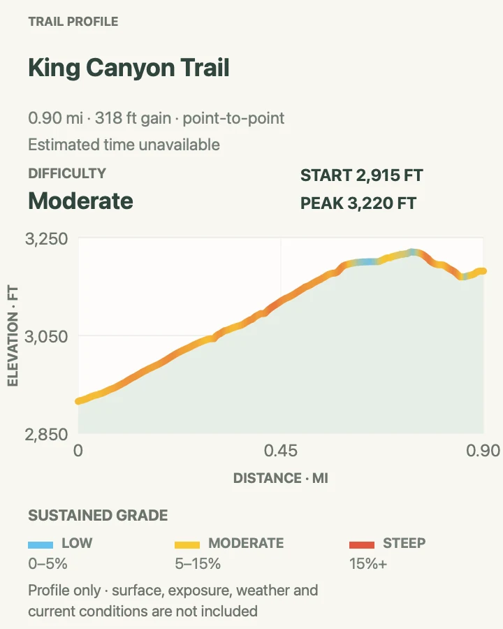
King Canyon Trail
- Distance
- 0.8 mile one way
- Elevation gain
- 320 feet
- Time
- Allow 35 to 60 minutes one way
- Difficulty
- Moderate
- Route type
- Point to point
- Parking
- Use King Canyon Trailhead on Tucson Mountain Park land outside the national park boundary and keep the roadside approach clear.
- Best time
- Morning, before reflected heat builds in the canyon.
- Pets
- Pets are prohibited on this trail.
King Canyon uses an old roadbed toward a four-way junction in the Tucson Mountains. The broad middle section makes navigation straightforward, while views open toward Wasson Peak and west across Avra Valley.
The official survey records natural stone steps and a narrow, rocky final two hundred feet despite the old-road character. This is a one-way trail section. Hikers returning to the trailhead should budget roughly twice the card distance or connect only to a separately planned route.
What helps on this route
- Do not confuse the broad roadbed with permission for vehicles or bicycles where prohibited.
- Record the four-way junction before continuing onto another named trail.
Terrain and access: Graded old road with gravel, natural steps near the gate, and a narrower rocky finish.

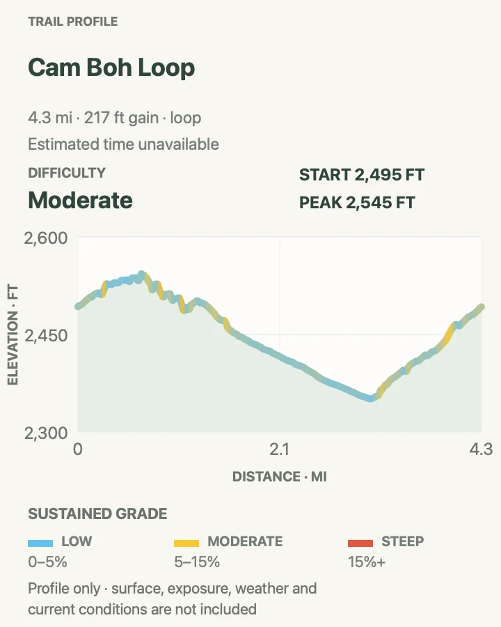
Cam Boh Loop
- Distance
- 4.0 miles
- Elevation gain
- 220 feet
- Time
- Allow 2 to 3 hours
- Difficulty
- Moderate
- Route type
- Loop
- Parking
- Begin at the Cam-Boh trailhead in the Tucson Mountain District and leave space for equestrian use.
- Best time
- A cool morning with good visibility toward Panther Peak.
- Pets
- Pets are prohibited on this trail.
Cam Boh combines Cam-Boh Trail, Panther Peak Wash, and Roadrunner Trail. The loop moves from more technical steps to a sandy wash beneath Panther Peak and then to broader, flatter tread, so its character changes several times without requiring a summit climb.
NPS describes this as a lower-use hiking route favored by equestrians. Roughly half the surveyed ground is soft sand, which can slow the circuit and tire ankles even where the grade is gentle. Close gates as posted and yield early to horses.
What helps on this route
- Carry the three trail names with the map; the loop is a constructed itinerary rather than one continuous named path.
- Step to the safe downhill side when an equestrian group approaches.
Terrain and access: Rock steps, firm desert soil, very soft wash sand, and a broad road-like return.

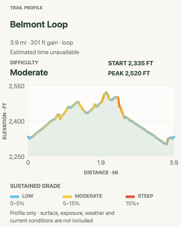
Belmont Loop
- Distance
- 3.7 miles
- Elevation gain
- 300 feet
- Time
- Allow 2 to 3 hours
- Difficulty
- Moderate
- Route type
- Loop
- Parking
- Use the small dirt North Belmont access lot in the neighborhood north of the park; do not block homes, gates, or horse access.
- Best time
- Early morning when the exposed northern approach is cool.
- Pets
- Pets are prohibited on this trail.
Belmont joins Belmont, Vertical Cliffs, Abington, Veterans, and Animal Wash trails in the less-visited northwestern part of the park. An old windmill gives the circuit a concrete destination, while the approach crosses broad cactus country away from the busier scenic-drive stops.
Much of the tread is wide and firm like a retired road, but a substantial portion runs in soft wash sand. Several short pitches exceed twenty percent. NPS also notes that a board at the trailhead blocked adaptive-device entrance during its survey, so current physical access should be checked before arrival.
What helps on this route
- Keep neighborhood noise and parking impact low at the small access point.
- Expect the wash to take longer than a firm trail of the same distance.
Terrain and access: Wide hard-packed tread, soft wash travel, and several brief steep grades.

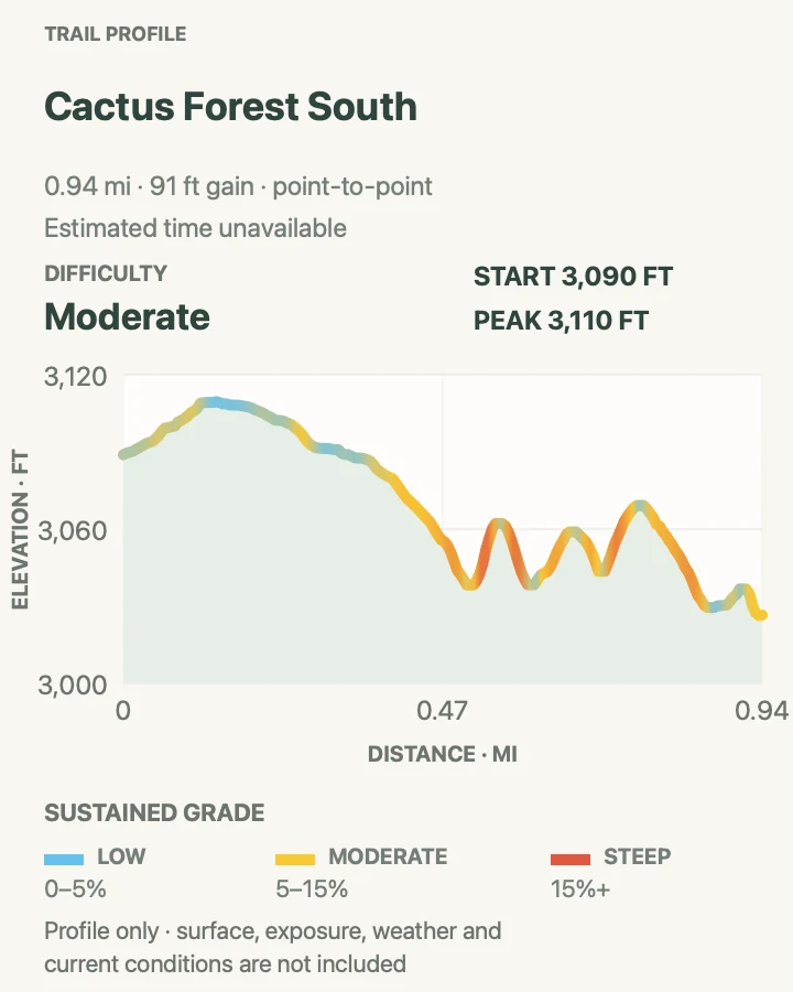
Cactus Forest South
- Distance
- 0.9 mile one way
- Elevation gain
- 90 feet
- Time
- Allow 35 to 60 minutes one way
- Difficulty
- Moderate
- Route type
- Point to point
- Parking
- Use the signed south trailhead on the two-way portion of Cactus Forest Loop Drive or arrange a legal pickup at the Old Spanish Trail pullout.
- Best time
- A cool morning after confirming the unmarked southern pickup point.
- Pets
- Pets are prohibited on this trail.
This southern segment of the greater Cactus Forest Trail winds between the loop road and an unmarked access on Old Spanish Trail. It receives less foot traffic than several nearby developed trails, yet crosses the same dense mix of saguaros, palo verde, and desert shrubs.
The NPS survey found narrow hard-packed tread, rocky erosion, deep ruts, and grades that briefly exceed twenty percent. Because the official distance is one way and the southern access is easy to miss, decide between a pickup and a full retrace before starting.
What helps on this route
- Pin both legal endpoints before leaving service.
- Do not use erosion channels as parallel tread around rocky sections.
Terrain and access: Narrow hard desert soil with rocky ruts, wash erosion, and short steep grades.

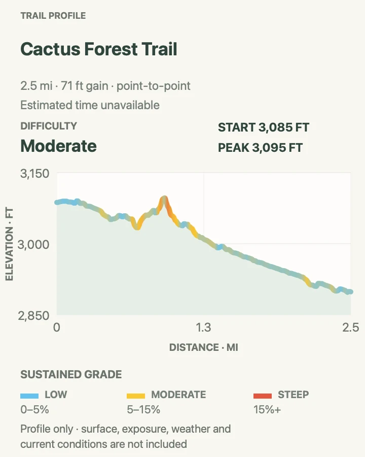
Cactus Forest Trail
- Distance
- 2.5 miles one way
- Elevation gain
- 70 feet
- Time
- Allow 1.5 to 2.5 hours one way
- Difficulty
- Moderate
- Route type
- Point to point
- Parking
- Use either the Cactus Forest North or Cactus Forest South trailhead on Cactus Forest Loop Drive and arrange the return.
- Best time
- Morning, with extra caution after rain at the wash crossings.
- Pets
- Pets are prohibited on this trail.
The central Cactus Forest Trail passes old lime-kiln remains and crosses Javelina Wash between the north and south trailheads. A short signed side area interprets the kilns. Lime Falls may show water after rain, but recent runoff is also a reason to avoid wash travel.
The north half-mile is broad and comparatively level. South of the kilns, the route becomes rockier and narrower with modest climbs and three sandy wash crossings. Hikers and equestrians share the corridor, and bicycles may be present on portions permitted for multi-use travel.
What helps on this route
- Arrange the second vehicle or retrace plan before entering the one-way loop road.
- Keep clear of historic kiln remains and leave artifacts untouched.
Terrain and access: Firm desert tread, three soft wash crossings, rocky narrow sections, and mild rolling elevation.

Mica View Trail
- Distance
- 0.7 mile one way
- Elevation gain
- 55 feet
- Time
- Allow 25 to 45 minutes one way
- Difficulty
- Easy
- Route type
- Point to point
- Parking
- Start at Mica View Picnic Area inside the loop drive or at Broadway Trailhead; arrange a pickup or retrace the paved path.
- Best time
- Morning or late afternoon for lower pavement temperatures and clear Mica Mountain views.
- Pets
- Leashed pets are permitted; use a leash no longer than six feet and protect paws from hot pavement.
Mica View connects Broadway Trailhead with Mica View Picnic Area on a wide paved path. Saguaros crowd close to the corridor, and the eastward view rises toward Mica Mountain, the park's highest summit.
NPS describes the tread as firm, consistently wide, and built to accessibility standards, with a gentle typical grade. The published distance is one way. Retracing creates a straightforward 1.4-mile outing, while longer combinations should be checked against the current trail map rather than improvised at a junction.
What helps on this route
- Expect other hikers and mobility devices on the paved corridor.
- Keep leashes short near cactus and when passing other visitors.
Terrain and access: Wide firm pavement with gentle grades and little shade.

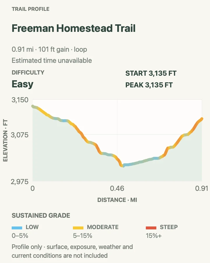
Freeman Homestead Trail
- Distance
- 0.9 mile
- Elevation gain
- 100 feet
- Time
- Allow 45 to 75 minutes
- Difficulty
- Easy
- Route type
- Loop
- Parking
- Park at the signed Freeman Homestead trailhead on Cactus Forest Loop Drive.
- Best time
- A cool morning, especially when wildlife activity is easier to observe quietly.
- Pets
- Pets are prohibited on this trail.
Freeman Homestead descends toward a 1930s homestead site and crosses a wash where mature trees can provide patches of shade. Interpretive signs connect the human history with the surrounding desert. The wash may attract wildlife, but water is absent for much of the year.
Stone steps lead into and out of the sandy channel. Social paths are common inside the wash, so follow metal posts and rock arrows rather than the most heavily disturbed line. The trail returns to firm desert ground for the climb back to the road.
What helps on this route
- Pause at the wash markers before choosing the exit path.
- Observe wildlife from the signed trail and never approach an animal using the shade.
Terrain and access: Firm soil, stone steps, roughly two-tenths of a mile in soft sand, and a shaded wash crossing.

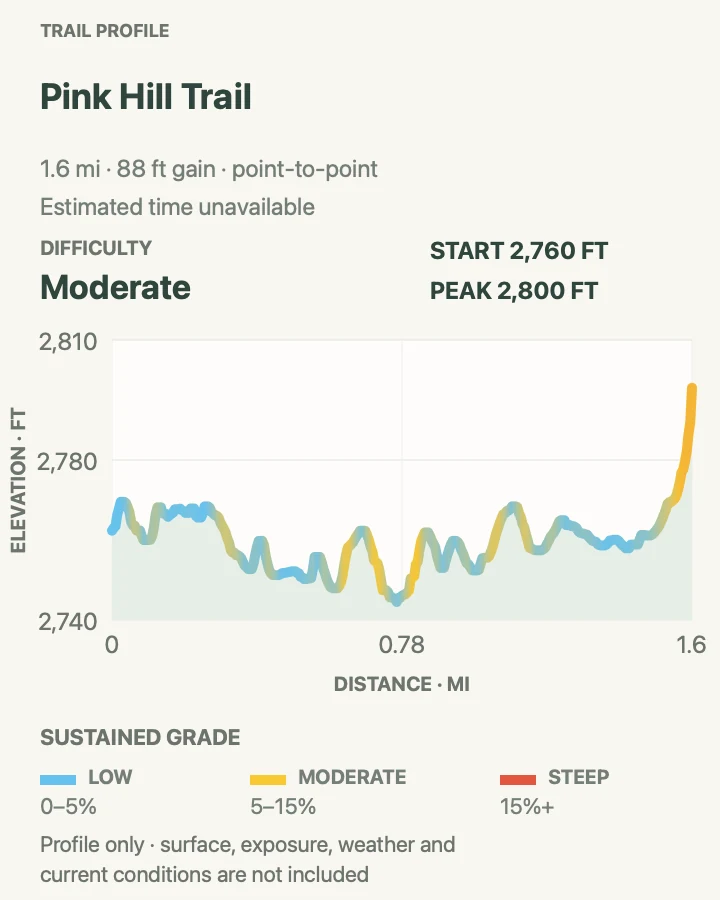
Pink Hill Trail
- Distance
- 1.5 miles one way
- Elevation gain
- 90 feet
- Time
- Allow 1 to 1.5 hours one way
- Difficulty
- Moderate
- Route type
- Point to point
- Parking
- Begin at Broadway Trailhead and use the Shantz Trail connection to reach Pink Hill; plan the return from the mapped endpoint.
- Best time
- A clear cool morning for views from the hill.
- Pets
- Pets are prohibited on this trail.
Pink Hill uses the Shantz connection from Broadway before climbing a spur to the pink-soil summit. The hill gives open views across the Rincon foothills and differs from the paved Mica View route nearby.
Most grades are moderate, but the last two hundred feet contain tightly spaced steps. The official survey counted numerous short stair sets and a few taller steps. Several junctions offer other combinations, yet this card follows only the verified one-way line to keep the distance and profile honest.
What helps on this route
- Save the Shantz-to-Pink-Hill junction for the return.
- Use the steps rather than widening the soft pink slope around them.
Terrain and access: Firm desert soil, brief sand, many low steps, and a steeper final hill climb.

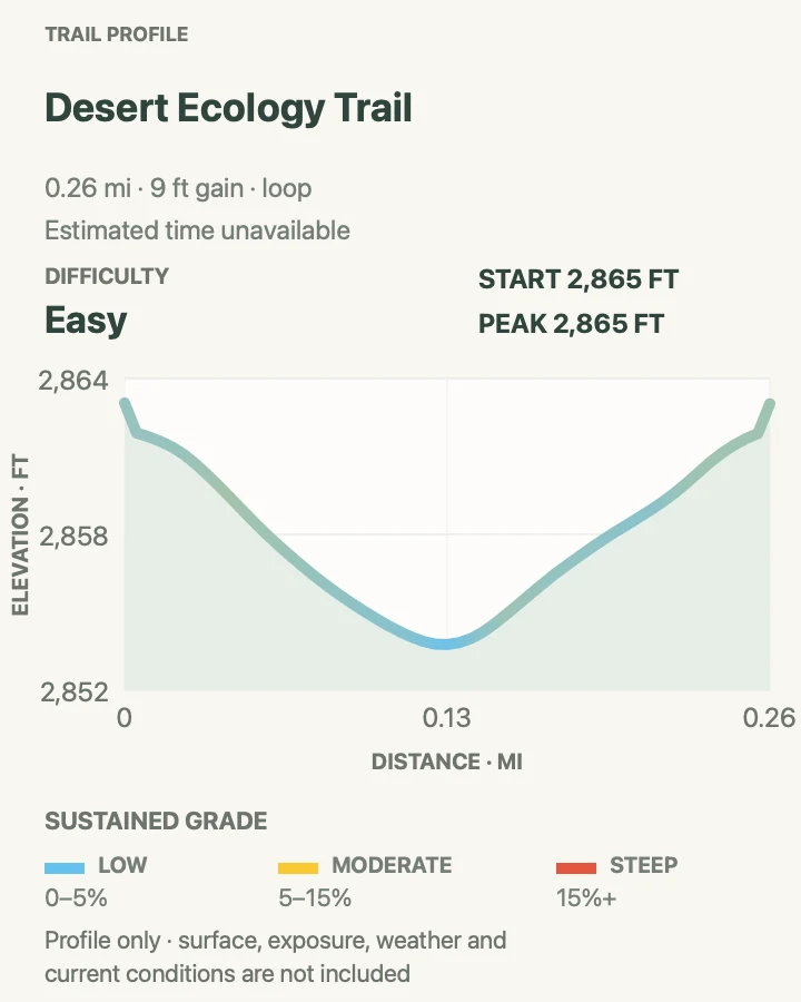
Desert Ecology Trail
- Distance
- 0.25 mile
- Elevation gain
- 10 feet
- Time
- Allow 15 to 30 minutes
- Difficulty
- Easy
- Route type
- Loop
- Parking
- Use the signed pullout on Cactus Forest Loop Drive; NPS lists six standard spaces and one accessible space.
- Best time
- Any cooler hour when the interpretive stops can be taken slowly.
- Pets
- Leashed pets are permitted; use a leash no longer than six feet and monitor paw temperature.
Desert Ecology is a quarter-mile paved loop with signs explaining common Sonoran Desert plants and processes. Benches spaced along the route make it a useful low-commitment stop for visitors who want interpretation without rough trail.
NPS measured a wide, firm surface with low typical and maximum grades. Accessibility does not eliminate desert exposure: the pavement and surrounding air can be dangerous during hot weather, and the small lot may fill during busy periods.
What helps on this route
- Leave the accessible parking space available unless it is needed.
- Carry water even for the short loop during warm weather.
Terrain and access: Wide paved loop with benches, gentle grades, and firm mobility-device access.

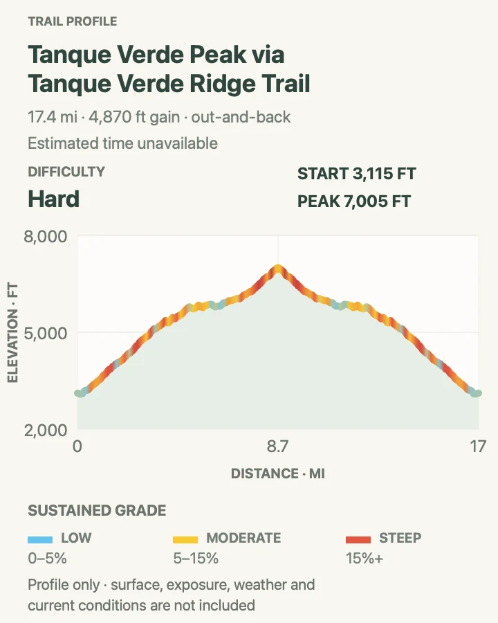
Tanque Verde Peak via Tanque Verde Ridge Trail
- Distance
- 17.4 miles round trip
- Elevation gain
- 4,870 feet
- Time
- Allow a full day
- Difficulty
- Strenuous
- Route type
- Out and back
- Parking
- Begin at the Tanque Verde Ridge trailhead near Javelina Picnic Area on Cactus Forest Loop Drive and observe gate hours.
- Best time
- A cool stable-weather day with a pre-dawn or sunrise start.
- Pets
- Pets are prohibited on this trail.
Tanque Verde Ridge is the collection's longest outing. It climbs steadily away from the desert floor toward Tanque Verde Peak at roughly mile 8.7, passing through major changes in vegetation and exposure along the way. The distance and lack of easy bailout make this a serious day rather than an extended casual walk.
NPS presents intermediate turnarounds along the ridge, so a summit attempt should have firm time, water, and weather limits. Lightning, heat, fatigue, or a late start are sufficient reasons to turn around below the peak. Backcountry water cannot be assumed available or safe.
What helps on this route
- Set turnaround times for both the peak and any intermediate objective before starting.
- Carry layers for the higher ridge as well as sun protection and the full water supply.
Terrain and access: Long exposed ridge climb with sustained gain, rocky tread, changing vegetation, and remote turnaround decisions.

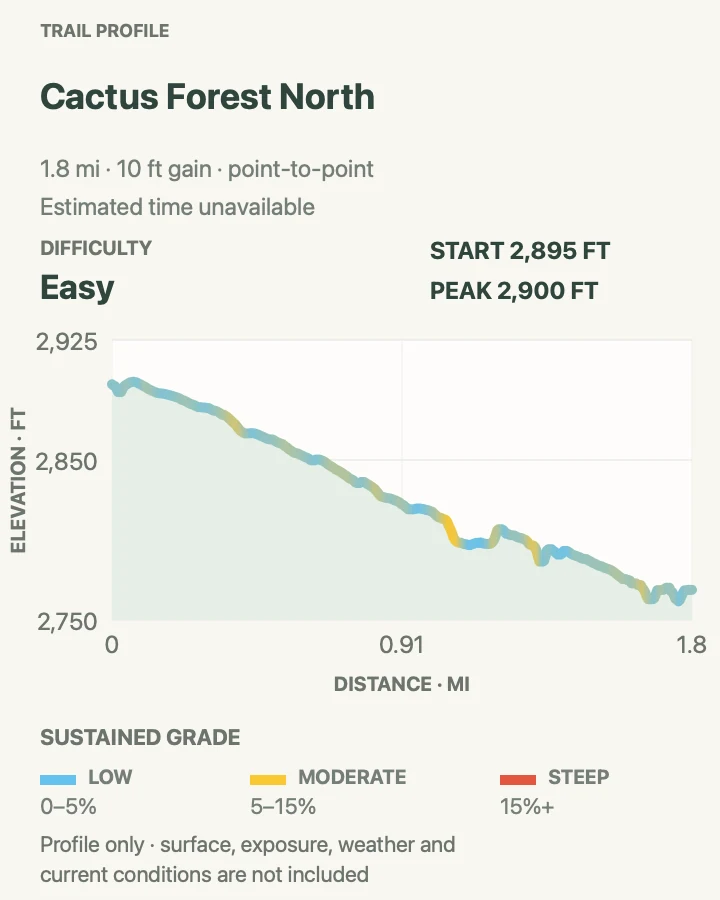
Cactus Forest North
- Distance
- 1.7 miles one way
- Elevation gain
- 10 feet
- Time
- Allow 1 to 1.5 hours one way
- Difficulty
- Easy
- Route type
- Point to point
- Parking
- Use Cactus Forest North Trailhead on the one-way loop drive or Broadway Trailhead; arrange the return before starting.
- Best time
- Morning, when the flatter cactus forest remains cool.
- Pets
- Pets are prohibited on this trail.
Cactus Forest North threads among saguaros, barrel cactus, palo verde, and creosote between the scenic drive and Broadway Trailhead. NPS characterizes it as one of the flatter, wider, and less-eroded dirt trails in the cactus forest.
The path is still natural desert tread. Stone steps, a deep eroded rut, and compacted but soft wash crossings interrupt the generally firm surface. Horses may use the trail. The stated mileage covers one direction, so an out-and-back is approximately twice as long.
What helps on this route
- Account for the one-way scenic-drive pattern when placing a second vehicle.
- Yield to horses on a firm, visible section instead of a wash edge.
Terrain and access: Mostly firm packed soil with low grades, spaced stone steps, one deep rut, and soft wash crossings.

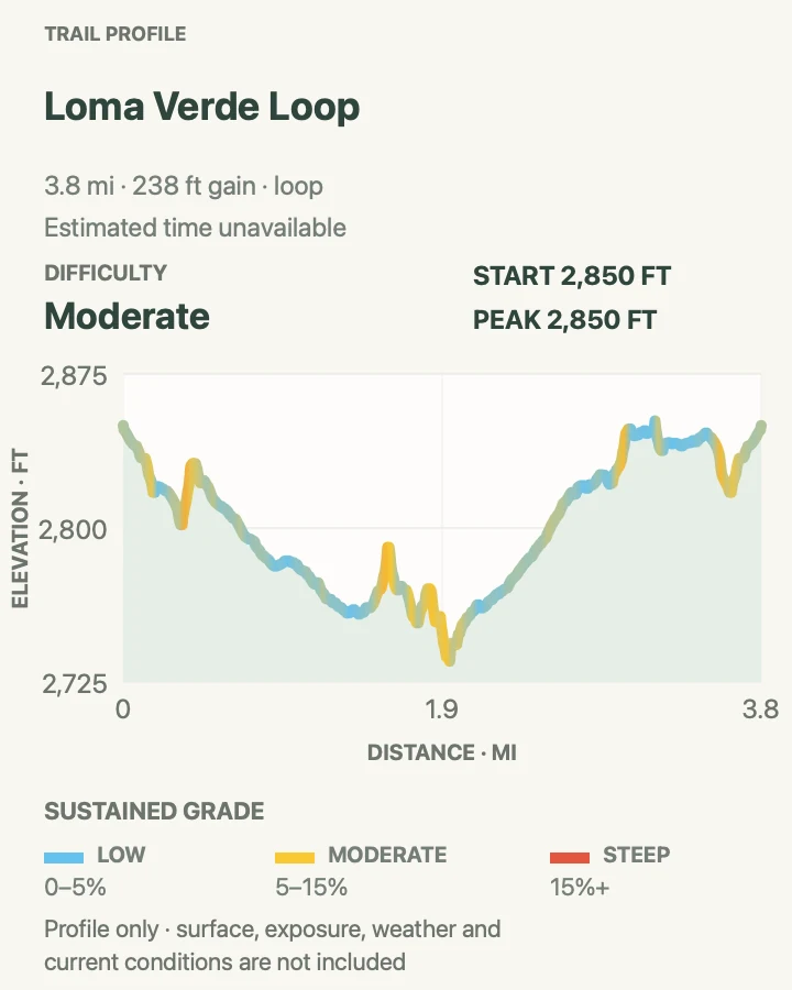
Loma Verde Loop
- Distance
- 3.8 miles
- Elevation gain
- 240 feet
- Time
- Allow 2 to 3 hours
- Difficulty
- Moderate
- Route type
- Loop
- Parking
- Park at the Loma Verde trailhead on Cactus Forest Loop Drive and note the one-way road direction.
- Best time
- A cool morning after checking washes for recent runoff.
- Pets
- Pets are prohibited on this trail.
Loma Verde follows a chain of signed trails through cactus forest, crosses Monument Wash, and returns to the loop drive. NPS recommends the circuit as a moderate 3.8-mile outing with limited net elevation change, but sandy channels and repeated junctions add work beyond the headline gain.
This is a route to navigate, not one continuously named trail. Keep the map available at every connector and avoid making a parallel line through the wash. Recent rain can change footing or make the crossing unsafe even when the rest of the loop is dry.
What helps on this route
- Check each connector name before leaving a junction.
- Postpone the loop when runoff is moving through Monument Wash.
Terrain and access: Firm cactus-forest paths linked by sandy wash crossings and modest rolling grades.

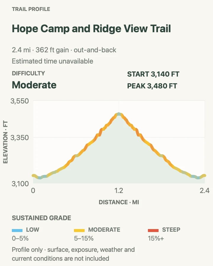
Hope Camp and Ridge View Trail
- Distance
- 2.0 miles round trip
- Elevation gain
- 360 feet
- Time
- Allow 1 to 1.5 hours
- Difficulty
- Moderate
- Route type
- Out and back
- Parking
- Begin at the Loma Alta trailhead at the south end of Camino Loma Alta and use only signed visitor parking.
- Best time
- Morning or late afternoon in cool weather.
- Pets
- Pets are prohibited on this trail.
This outing uses the Hope Camp corridor and the Ridge View connection for a short out-and-back in the southern Rincon foothills. The open route looks toward Rincon Peak and crosses broad desert ground that receives less scenic-drive traffic than the central cactus-forest trailheads.
NPS publishes the hike at two miles with about four hundred feet of elevation change. The corridor continues deeper into the park, so the mapped turnaround matters. Do not extend the day merely because the broad track remains easy to follow.
What helps on this route
- Mark the planned Ridge View turnaround before starting.
- Keep driveway and emergency access clear at the neighborhood trailhead.
Terrain and access: Exposed foothill path and old-road sections with a steady moderate rise and little shade.

Garwood Dam and Wildhorse Tank
- Distance
- 6.4 miles
- Elevation gain
- 1,060 feet
- Time
- Allow 4 to 5.5 hours
- Difficulty
- Strenuous
- Route type
- Loop with out-and-back spur
- Parking
- Use Douglas Spring Trailhead at the east end of Speedway Boulevard and keep horse-trailer and emergency access open.
- Best time
- A cool-season morning with dry washes and ample daylight.
- Pets
- Pets are prohibited on this trail.
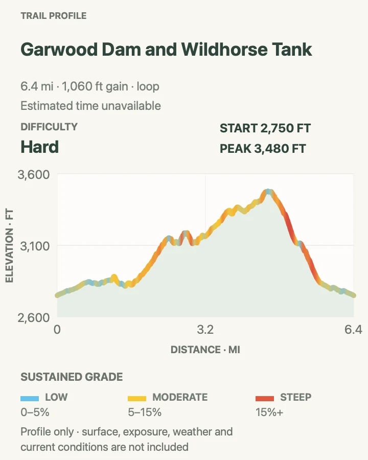
From Douglas Spring Trailhead, the official itinerary turns onto Garwood Trail, reaches Carrillo Trail, passes the historic dam, and continues over a ridge to the Wildhorse junction. A short out-and-back spur reaches Little Wildhorse Tank before Carrillo and Douglas Spring close the circuit.
The route climbs through rocky, eroded ground and uses several washes and switchbacks. Water at the tank is not a drinking supply and may be absent. This longer loop replaces the shorter Garwood Dam route in the collection because it contains most of that approach while adding a distinct ridge, tank, and return corridor.
What helps on this route
- Save the Wildhorse spur and its return junction separately from the main loop.
- Treat every tank and wash as unreliable water and carry the full supply from the trailhead.
Terrain and access: Rocky eroded trails, deep ruts, switchbacks, wash travel, a steep tank spur, and sustained exposed climbing.

Three Tank Trail
- Distance
- 2.2 miles one way
- Elevation gain
- 810 feet
- Time
- Allow 1.5 to 2.5 hours one way
- Difficulty
- Moderate
- Route type
- Point to point
- Parking
- Treat this as a backcountry connector between the Wildhorse and Douglas Spring trail systems; use a separately planned legal trailhead and return rather than expecting parking at either mapped endpoint.
- Best time
- A cool stable-weather morning as part of a planned through-route.
- Pets
- Pets are prohibited on this trail.
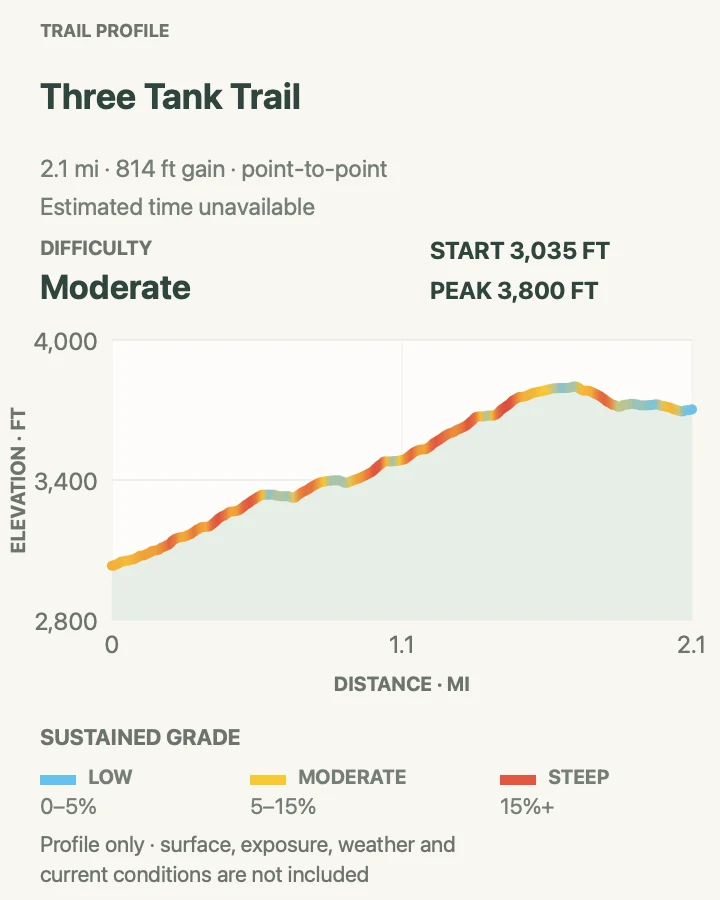
Three Tank Trail is an official named connector rather than a self-contained roadside walk. Current NPS centerlines identify the corridor, and the mapped 2.2-mile point-to-point geometry follows the named OSM hiking relation tagged to Saguaro National Park and the park's current maps page.
The line climbs substantially from the Wildhorse side toward Douglas Spring and crosses remote foothill terrain. Because neither endpoint is presented here as a parking area, use this section only inside a complete route plan with a legal start, return, adequate water, and enough daylight.
What helps on this route
- Build the approach and return before counting this connector in the day's mileage.
- Carry an offline map and verify every Wildhorse, Carrillo, and Douglas Spring junction.
Terrain and access: Remote point-to-point foothill path with sustained climbing, rocky grades, wash crossings, and no trailhead services at the mapped endpoints.

Official planning sources
Trail access and safety details were checked against these National Park Service pages. The maps and profiles follow the corresponding route geometry.
Map data © OpenStreetMap contributors. Trail geometry and planning details include National Park Service public information.