21 Best Hikes in North Cascades National Park
Twenty-one distinct North Cascades hikes along State Route 20, Cascade River Road, and Stehekin, with custom terrain maps, measured profiles, and live park conditions.
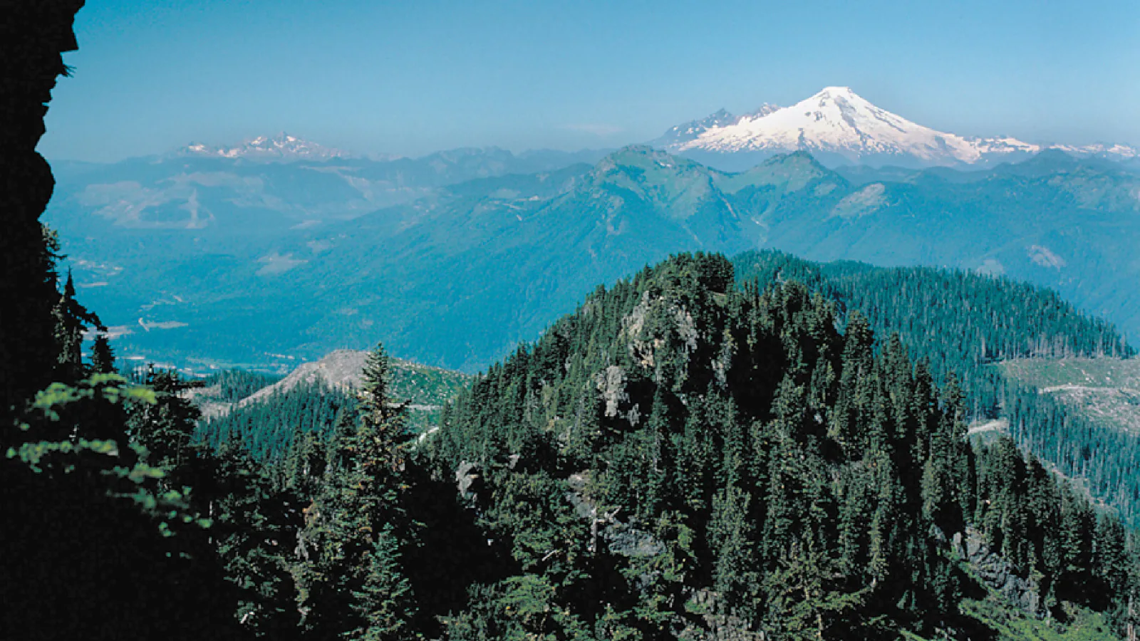
North Cascades National Park Service Complex is not one compact trail district. State Route 20 reaches the Skagit and Ross Lake side, Cascade River Road serves two major alpine trailheads, and Stehekin is reached by boat, plane, or trail at the head of Lake Chelan. A useful hiking plan begins by choosing one of those access systems.
These twenty-one routes range from a short forest and rock-shelter connection to steep lookout climbs and full-day passes. The distance on each card follows the current NPS itinerary. Elevation gain comes from the same preserved route geometry used for the terrain map and profile, so the measurements, maps, and editorial route all refer to one line.
Planning information was checked on September 1, 2026. Fire closures, smoke, snow, washouts, bridge damage, road gates, high water, and shuttle changes can alter a trip quickly. Read the live condition and weather panels, then confirm the official trail and road reports before leaving service.
Live park weather
North Cascades National Park
North Cascades Visitor Center
Loading the latest conditions and alerts…
What changes a hiking day here
Separate the highway, Cascade River Road, and Stehekin days
State Route 20 trailheads can be hours from Stehekin even though both belong to the same park complex. Stehekin has no road connection to the outside highway system. Cascade Pass and Hidden Lake use separate unpaved approaches off the Cascade River corridor. Do not group routes by straight-line distance on a map.
Check the access road before committing to an alpine trail
Cascade River Road is paved only for its first section and becomes rough gravel, narrow, and steep near the Cascade Pass trailhead. Hidden Lake uses Forest Road 1540, while Thornton Lakes uses a separate gravel spur. Snow, washouts, and seasonal gates can close any of them before the trail itself is closed.
Treat snow and stream crossings as route conditions
High routes can hold steep snow well into summer, and lower forest trails can have high creek crossings, windfall, or flood damage. Carry navigation that does not depend on reception, turn around when a crossing is unsafe, and use traction or an ice axe only when the route and your training call for them.
Build Stehekin transportation into the itinerary
Ferry times, the Stehekin Valley Shuttle, bike access, and private-property boundaries determine which trailheads are practical. Rainbow Loop is a point-to-point trail between upper and lower trailheads; Agnes Gorge and Agnes Creek normally begin near High Bridge; Buckner Orchard lies farther up-valley. Confirm the return before starting.
Carry food and water for a change in schedule
A delayed shuttle, smoky afternoon, slow gravel road, or unexpected snowfield can turn a planned half day into a long one. Water sources can dry up late in the season and must be treated when present. Current NPS reports control over any source shown on a map.
Respect wildlife and land-unit rules
The park complex contains national park and national recreation area lands with different pet and camping rules. Check the rule for the exact trail, store food as required, give bears and mountain goats space, and never approach wildlife for a photograph.
| Trail | Distance | Time | Difficulty | Best for |
|---|---|---|---|---|
| Rock Shelter Trail | 0.3 mile one way | Allow 20 to 40 minutes one way | Easy | A short forest and geology stop near Newhalem |
| Happy Creek Falls Trail | 2.2 miles round trip | Allow 1 to 1.5 hours | Moderate | Forest, cascading water, and a compact waterfall spur |
| Thornton Lakes Trail | 10.4 miles round trip | Allow 6 to 8 hours | Strenuous | A sustained forest climb to alpine lakes |
| Hidden Lake Lookout Trail | 9.0 miles round trip | Allow 6 to 8 hours | Strenuous | An alpine basin and historic fire lookout |
| Cascade Pass Trail | 7.4 miles round trip | Allow 4 to 6 hours | Strenuous | A maintained climb to glacier-ringed Cascade Pass |
| Stetattle Creek Trail | 6.0 miles round trip | Allow 3 to 4.5 hours | Moderate | A quieter forest corridor above a steep creek |
| Sourdough Mountain Trail | 10.4 miles round trip | Allow 7 to 10 hours | Strenuous | A major climb to a historic lookout and wide lake views |
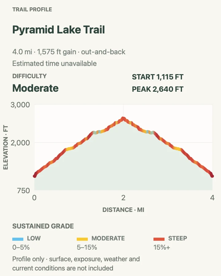
| Pyramid Lake Trail | 4.2 miles round trip | Allow 2.5 to 4 hours | Moderate | A steep forest climb to a small mountain lake |
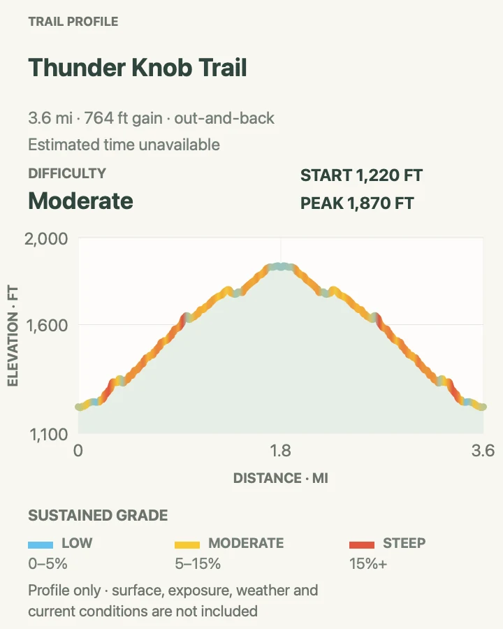
| Thunder Knob Trail | 3.8 miles round trip | Allow 2 to 3 hours | Moderate | An accessible-scale climb to views over Diablo Lake |
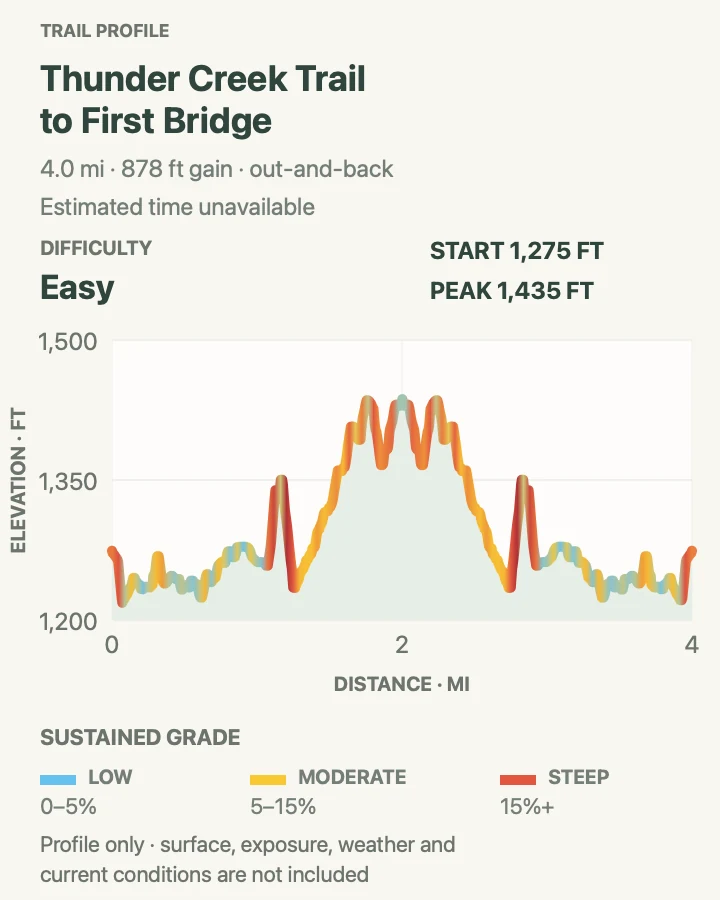
| Thunder Creek Trail to First Bridge | 4.0 miles round trip | Allow 2 to 3 hours | Easy | Old-growth forest and glacial-blue Thunder Creek |
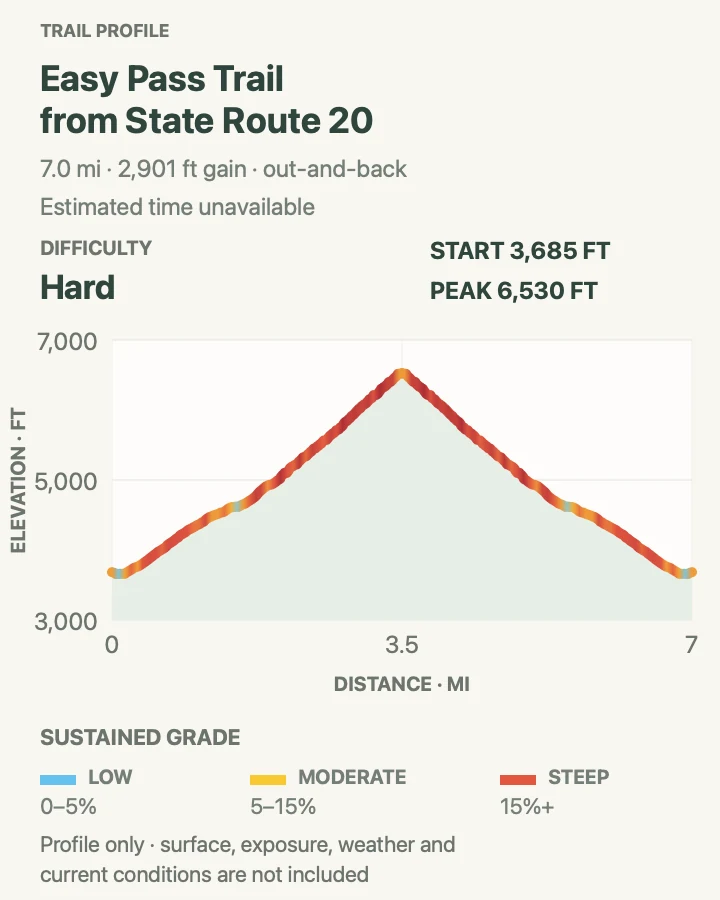
| Easy Pass Trail from State Route 20 | 7.0 miles round trip | Allow 5 to 7 hours | Strenuous | A steep climb from forest to an open alpine pass |
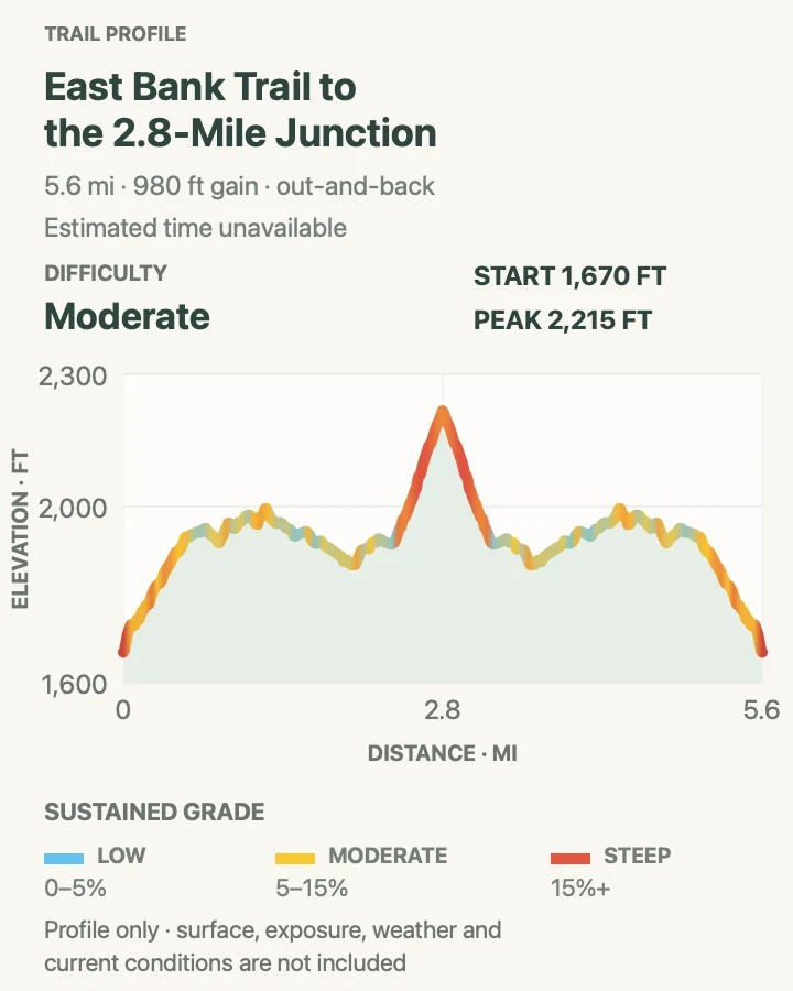
| East Bank Trail to the 2.8-Mile Junction | 5.6 miles round trip | Allow 3 to 4 hours | Moderate | Low-elevation forest and a flexible introduction to the East Bank corridor |
| Rainbow Loop Trail | 4.4 miles one way | Allow 3 to 4 hours one way | Moderate | Stehekin Valley views and an early-season point-to-point hike |
| Lakeshore Trail to Flick Creek | 7.0 miles round trip | Allow 4 to 5.5 hours | Moderate | Lake Chelan shoreline views and a defined Flick Creek turnaround |
| Imus Creek Trail | 0.8 mile round trip | Allow 30 to 60 minutes | Easy | A short forest climb above Stehekin Landing |
| Stehekin River Trail | 6.4 miles round trip | Allow 3.5 to 5 hours | Moderate | River forest, beaver habitat, flowers, and fall salmon |
| Buckner Canal Trail to Buckner Orchard | 0.6 mile round trip | Allow 30 to 60 minutes | Easy | A short walk through Stehekin's orchard and irrigation history |
| Company Creek Trail to Glacier Peak Wilderness | 3.6 miles round trip | Allow 3 to 4.5 hours | Strenuous | A steep, quiet climb to the Glacier Peak Wilderness boundary |
| Agnes Gorge Trail | 5.0 miles round trip | Allow 2.5 to 4 hours | Easy | A varied forest walk to a narrow gorge and seasonal waterfalls |
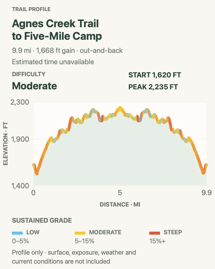
| Agnes Creek Trail to Five-Mile Camp | 11.0 miles round trip | Allow 5.5 to 8 hours | Moderate | A long forest day on the Pacific Crest Trail beside Agnes Creek |
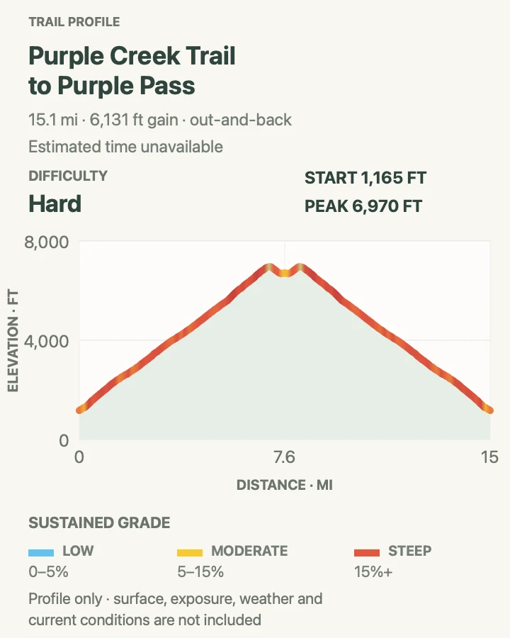
| Purple Creek Trail to Purple Pass | 15.0 miles round trip | Allow 9 to 12 hours | Strenuous | A major climb from Lake Chelan to Purple Pass |
Rock Shelter Trail
- Distance
- 0.3 mile one way
- Elevation gain
- 55 feet
- Time
- Allow 20 to 40 minutes one way
- Difficulty
- Easy
- Route type
- Point to point
- Parking
- Use a legal Newhalem-area parking area and follow the signed local trail network; this short mapped segment is not a self-contained roadside loop.
- Best time
- A dry daylight visit paired with another Newhalem-area walk.
- Pets
- Check the current rule for this exact Newhalem-area segment before bringing a pet; trained service animals are allowed.
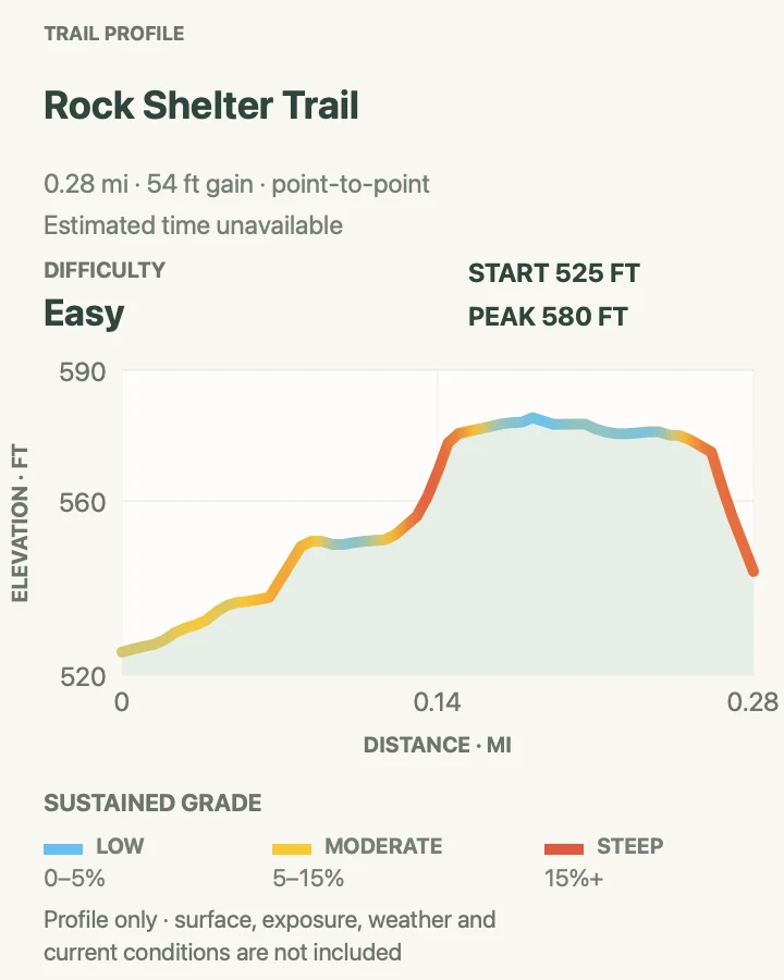
Rock Shelter Trail is the smallest route in this collection, but it is useful only when read as a connector. The preserved NPS centerline runs one way through the Newhalem trail system to a shallow rock-shelter setting rather than closing a loop at the parking area.
Because the published section is only three-tenths of a mile, junction choice matters more than endurance. Use the local NPS map to decide whether to retrace or continue on another signed path, and do not treat an unsigned bank or utility track as the return.
What helps on this route
- Save the Newhalem-area trail map, not just this short segment.
- Budget the return distance separately if retracing to the car.
Terrain and access: Short forest path with compact tread and a one-way finish that requires a planned return or connector.

Happy Creek Falls Trail
- Distance
- 2.2 miles round trip
- Elevation gain
- 700 feet
- Time
- Allow 1 to 1.5 hours
- Difficulty
- Moderate
- Route type
- Out and back
- Parking
- Use the signed Happy Creek trailhead parking along State Route 20 near Ross Lake and keep highway access clear.
- Best time
- Late spring through fall after confirming the path and creek crossings are open.
- Pets
- Confirm the current Ross Lake National Recreation Area pet rule for this trail before arrival.
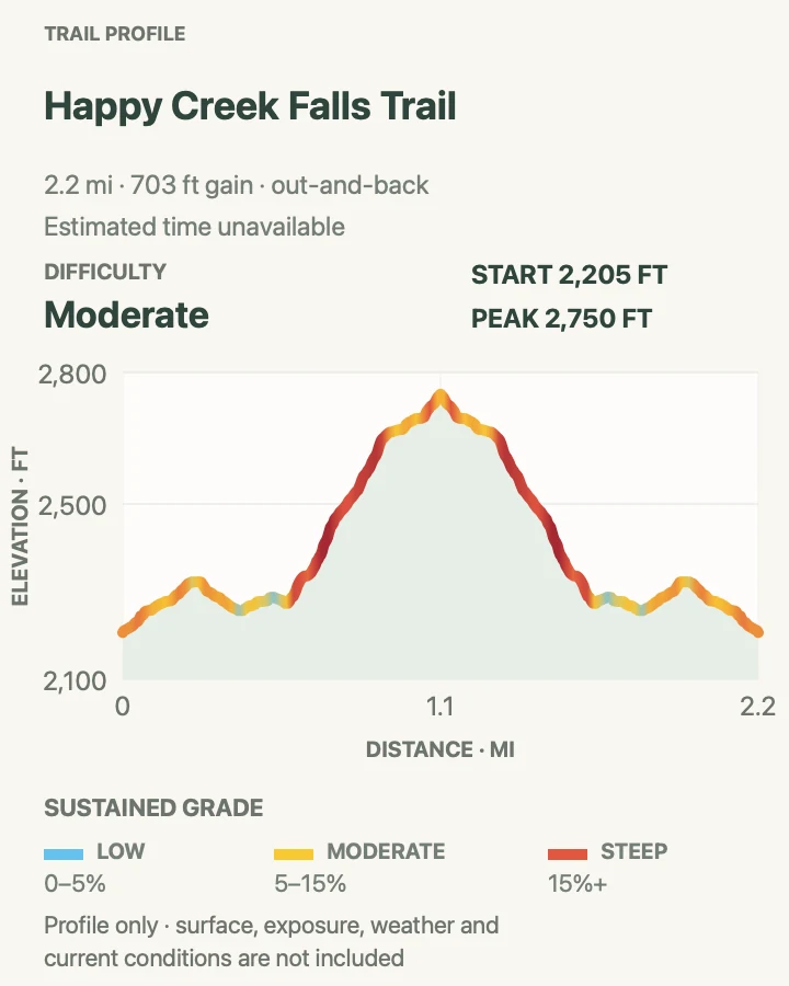
Happy Creek follows cool forest beside a cascading stream, then uses the named falls spur for the turnaround represented on this map. It is a modest-distance alternative when the high-country routes are smoky, snowy, or beyond the day's time budget.
Wet wood, roots, and spray can be more consequential than the route's overall grade. Stay on the developed tread near the falls and keep children back from slick rock and fast water.
What helps on this route
- Expect slick footing even when the highway is dry.
- Turn around at the mapped falls destination unless another signed itinerary is planned.
Terrain and access: Forested creek-side path with roots, damp surfaces, and a steeper waterfall spur.

Thornton Lakes Trail
- Distance
- 10.4 miles round trip
- Elevation gain
- 3,470 feet
- Time
- Allow 6 to 8 hours
- Difficulty
- Strenuous
- Route type
- Out and back
- Parking
- Reach the signed Thornton Lakes trailhead by the gravel Thornton Lakes Road off State Route 20; check the spur-road condition before leaving the highway.
- Best time
- A snow-free summer or early-fall day with a stable forecast.
- Pets
- Pets are prohibited where this route enters North Cascades National Park; verify the exact boundary rules before the trip.
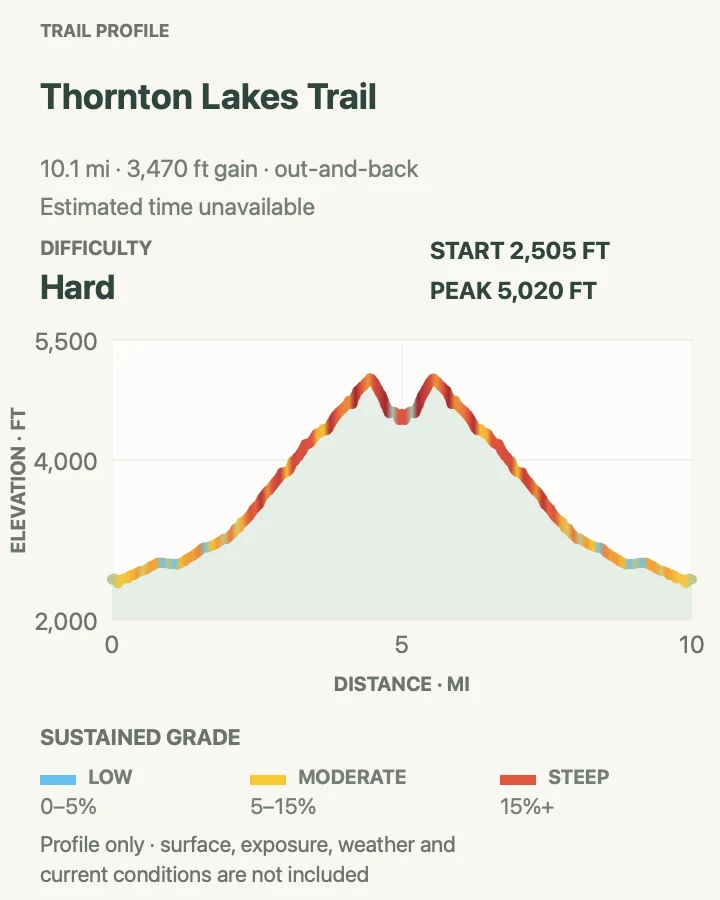
Thornton Lakes begins with a long forest climb before turning toward the basin below Trappers Peak. The lakes are the mapped destination; the exposed scramble toward the peak is a separate objective and is not included in this route.
The measured profile records roughly 3,470 feet of gain, enough to make road timing, daylight, and turnaround discipline central to the day. Snow can hide tread above the forest after lower trails have melted out.
What helps on this route
- Do not add Trappers Peak unless it is separately researched and conditions support exposed scrambling.
- Check both the highway and Thornton Lakes Road reports before driving to the spur.
Terrain and access: Long forest approach, steep switchbacks, rough alpine tread, and possible lingering snow near the lakes.


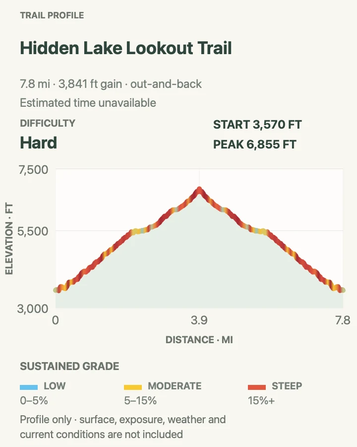
Cascade Pass Trail
- Distance
- 7.4 miles round trip
- Elevation gain
- 1,960 feet
- Time
- Allow 4 to 6 hours
- Difficulty
- Strenuous
- Route type
- Out and back
- Parking
- Drive Cascade River Road to its signed end only when the road is open; the final three miles are narrow, steep, and have limited passing room.
- Best time
- A clear snow-free day after Cascade River Road opens to the trailhead.
- Pets
- Pets are prohibited on Cascade Pass Trail; trained service animals are allowed.
Cascade Pass uses a carefully graded switchback climb from the end of Cascade River Road to an open pass framed by peaks and glaciers. This card ends at the pass. Sahale Arm is a longer, steeper continuation and does not count inside the 7.4-mile distance.
NPS publishes 1,700 feet of gain for the trail; the route geometry produces a similar profile. Parking can fill early, but roadside improvisation on the narrow upper road is not a safe substitute for a legal space.
What helps on this route
- Check the road gate and washout report before the long drive from Marblemount.
- Do not count Sahale Arm mileage or conditions as part of this Cascade Pass card.
Terrain and access: Numerous forest switchbacks, open talus and meadow, possible snow, and no camping at the pass.

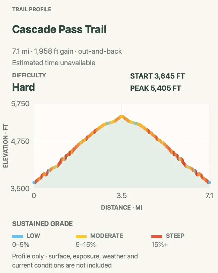
Stetattle Creek Trail
- Distance
- 6.0 miles round trip
- Elevation gain
- 1,260 feet
- Time
- Allow 3 to 4.5 hours
- Difficulty
- Moderate
- Route type
- Out and back
- Parking
- Use the signed Diablo-area access near the Stetattle Creek trailhead and obey local parking restrictions.
- Best time
- A dry low-water day from late spring through fall.
- Pets
- Confirm the current Ross Lake National Recreation Area pet rule for this trail before arrival.
Stetattle Creek follows a shaded drainage away from the busier Diablo Lake viewpoints. The six-mile outing clips the longer named trail at a three-mile turnaround and retraces the same corridor, creating a defensible day hike without implying a maintained endpoint farther upstream.
Roots, fallen trees, and sidehill exposure can slow progress even when the grade is moderate. High water and storm damage matter more here than a distant mountain forecast.
What helps on this route
- Use the mapped turnaround instead of selecting an arbitrary point from elapsed time.
- Give steep creek banks and unstable edges extra room after rain.
Terrain and access: Narrow forest trail with roots, side slopes, creek sound, and a mapped three-mile turnaround.

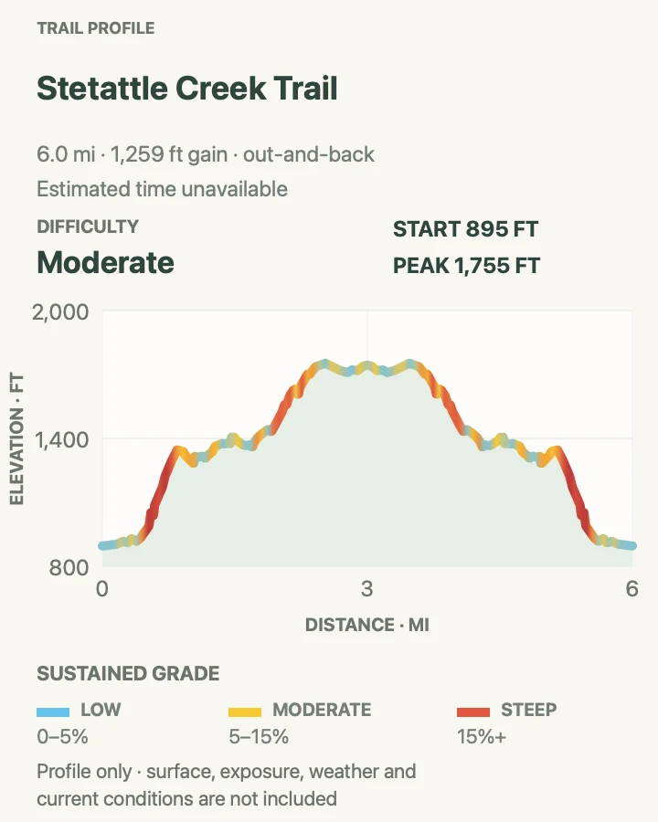
Sourdough Mountain Trail
- Distance
- 10.4 miles round trip
- Elevation gain
- 5,110 feet
- Time
- Allow 7 to 10 hours
- Difficulty
- Strenuous
- Route type
- Out and back
- Parking
- Use the signed Sourdough Mountain trailhead in Diablo and do not block local or emergency access.
- Best time
- A cool, clear snow-free day with an early start.
- Pets
- Confirm the current land-unit pet rule; pets are prohibited where the trail enters national park land.
Sourdough Mountain rises directly from the Diablo area to an old fire-lookout site above Ross and Diablo lakes. The grade begins early and offers few stretches that feel like a recovery on the way up.
The route-derived profile records roughly 5,110 feet of gain, slightly more than the current NPS summary because it measures every rise along the bound centerline. Carry enough water for the entire exposed return and leave the ridge when thunder or smoke worsens.
What helps on this route
- Start early enough that the descent is not forced into darkness.
- Do not rely on ridge water; confirm current sources and carry a conservative supply.
Terrain and access: Relentless switchbacks, exposed upper slopes, seasonal snow, and more than 5,000 feet of measured gain.

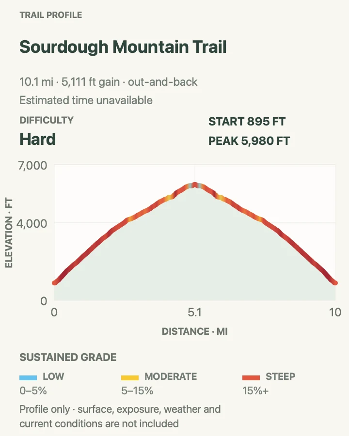
Pyramid Lake Trail
- Distance
- 4.2 miles round trip
- Elevation gain
- 1,570 feet
- Time
- Allow 2.5 to 4 hours
- Difficulty
- Moderate
- Route type
- Out and back
- Parking
- Use the signed Pyramid Lake trailhead along State Route 20 and keep the highway shoulder and traffic sightlines clear.
- Best time
- Late spring through fall after snow and windfall are checked.
- Pets
- Confirm the current Ross Lake National Recreation Area pet rule for this trail before arrival.
Pyramid Lake leaves the highway and climbs steadily through forest to a small lake beneath steep slopes. The enclosed destination is different from the open lake-and-peak views on Thunder Knob, even though the trailheads are in the same highway corridor.
The measured profile records about 1,575 feet of gain in four miles of route, so the hike is more sustained than its moderate label may suggest. Turn around at the developed lakeside destination rather than forcing a path around unstable shore terrain.
What helps on this route
- Expect the descent to remain slow on wet roots.
- Use only established lakeshore space and leave fragile banks intact.
Terrain and access: Rooted forest tread, sustained climbing, damp sections, and a confined lakeshore turnaround.

Thunder Knob Trail
- Distance
- 3.8 miles round trip
- Elevation gain
- 760 feet
- Time
- Allow 2 to 3 hours
- Difficulty
- Moderate
- Route type
- Out and back
- Parking
- Use the signed trailhead parking near Colonial Creek Campground on State Route 20; campground and day-use availability can differ.
- Best time
- Morning or evening from late spring through fall.
- Pets
- Confirm the current Ross Lake National Recreation Area pet rule for this trail before arrival.
Thunder Knob climbs from the Colonial Creek area to viewpoints over turquoise Diablo Lake and the surrounding peaks. It provides a distinct overlook rather than a shoreline hike, with enough gain to feel substantial without the commitment of Sourdough Mountain.
Spring runoff can affect the early creek crossing, and exposed viewpoints can be hot or windy. Stay on the signed overlook paths so repeated shortcuts do not widen the summit area.
What helps on this route
- Check the early creek crossing before committing the group to the climb.
- Return by the mapped route rather than using viewpoint social paths.
Terrain and access: Creek crossing, forest switchbacks, open viewpoint, and about 760 feet of measured gain.

Thunder Creek Trail to First Bridge
- Distance
- 4.0 miles round trip
- Elevation gain
- 880 feet
- Time
- Allow 2 to 3 hours
- Difficulty
- Easy
- Route type
- Out and back
- Parking
- Begin from the signed Thunder Creek access near Colonial Creek Campground and use designated day-use or trail parking.
- Best time
- Late spring through fall, especially on a warm day when the forest is welcome.
- Pets
- Confirm the current Ross Lake National Recreation Area pet rule for this trail before arrival.
This outing follows Thunder Creek through old-growth forest to the first wooden bridge, then retraces. The bridge is the deliberate turnaround; the named trail continues deep into the backcountry and should not be mistaken for the four-mile day hike.
The preserved line records more small rises than the NPS headline gain, but the walking remains gentler than the nearby knob and lake climbs. Fast water, damp roots, and bridge approaches still require attention.
What helps on this route
- Identify the first bridge as the turnaround before starting.
- Keep children close where the trail approaches fast water.
Terrain and access: Mostly gentle forest trail with roots, short rises, and a wooden-bridge turnaround.

Easy Pass Trail from State Route 20
- Distance
- 7.0 miles round trip
- Elevation gain
- 2,900 feet
- Time
- Allow 5 to 7 hours
- Difficulty
- Strenuous
- Route type
- Out and back
- Parking
- Use the signed Easy Pass trailhead along State Route 20 and do not park in travel lanes or block the trailhead entrance.
- Best time
- A snow-free summer or early-fall day with stable weather.
- Pets
- Check the current Okanogan-Wenatchee National Forest and park-boundary pet rules for the complete route.
Easy Pass is named for the crossing, not for the effort required to reach it. The State Route 20 approach climbs through forest and open basin terrain to broad views over Fisher Creek and the surrounding peaks.
This card uses the complete named approach from the highway. It replaces an incomplete NPS public-layer segment west of the pass whose profile would have run downhill from the wrong starting point.
What helps on this route
- Turn around at the pass; continuing down Fisher Creek changes the route into a different trip.
- Evaluate snow on the upper traverse before committing to it.
Terrain and access: Creek crossings, forest and meadow switchbacks, talus, steep grades, and possible lingering snow.

East Bank Trail to the 2.8-Mile Junction
- Distance
- 5.6 miles round trip
- Elevation gain
- 980 feet
- Time
- Allow 3 to 4 hours
- Difficulty
- Moderate
- Route type
- Out and back
- Parking
- Use the signed East Bank trailhead at State Route 20 near milepost 138 and keep the highway access clear.
- Best time
- Late spring through fall after checking bridge and creek conditions.
- Pets
- Confirm the current Ross Lake National Recreation Area pet rule for this trail before arrival.
East Bank is a long backcountry corridor, so this guide defines a specific day-hike version: walk 2.8 miles from the highway trailhead to the mapped junction, then retrace. That endpoint prevents a variable-distance trail from becoming an unsupported open-ended recommendation.
The forested route gains and loses elevation in small increments rather than making one continuous climb. Seasonal creeks, windfall, and trail work can determine the practical turnaround before mileage does.
What helps on this route
- Match the 2.8-mile junction on the saved map before turning around.
- Do not extend toward Ross Lake without recalculating daylight, food, and return mileage.
Terrain and access: Rolling lowland forest trail, creek crossings, roots, and a junction turnaround after 2.8 miles.

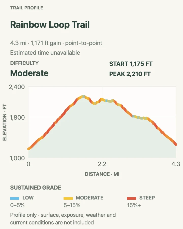
Rainbow Loop Trail
- Distance
- 4.4 miles one way
- Elevation gain
- 1,170 feet
- Time
- Allow 3 to 4 hours one way
- Difficulty
- Moderate
- Route type
- Point to point
- Parking
- Use the signed upper or lower Rainbow Loop trailhead in Stehekin and arrange shuttle, pickup, or the road walk before departure.
- Best time
- Late spring and early summer for flowers, after confirming fire-area conditions.
- Pets
- Check current Lake Chelan National Recreation Area pet and shuttle rules before the trip.
Rainbow Loop is not a closed loop. The 4.4-mile trail connects lower and upper Stehekin Valley Road trailheads while climbing through forest, open slopes, and areas shaped by the Rainbow Bridge Fire.
A longer circuit is possible by walking the road, but that mileage is outside this card. The point-to-point format works best with a planned shuttle or pickup and enough schedule margin for a delayed connection.
What helps on this route
- Do not assume the word loop returns you to the same trailhead.
- Carry sun and heat protection for exposed burned sections.
Terrain and access: Moderate climbing through forest and burn mosaic, exposed dry sections, and separate upper and lower trailheads.

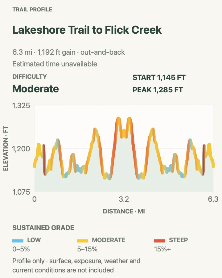
Lakeshore Trail to Flick Creek
- Distance
- 7.0 miles round trip
- Elevation gain
- 1,190 feet
- Time
- Allow 4 to 5.5 hours
- Difficulty
- Moderate
- Route type
- Out and back
- Parking
- Begin at Stehekin Landing and follow the signed Lakeshore Trail; respect private property and ferry operations near the landing.
- Best time
- Spring or a cool morning when the lower Lake Chelan shore is snow-free.
- Pets
- Check current Lake Chelan National Recreation Area pet rules and private-property constraints.
The full Lakeshore Trail runs far beyond a normal half-day outing. This version follows the northeast shore from Stehekin Landing to Flick Creek, an NPS-named day-hike destination 3.5 miles out, then returns the same way.
The trail stays near the lake but is not flat: side drainages and benches accumulate substantial gain. Remain on the public route where it passes private parcels and do not use docks or buildings without permission.
What helps on this route
- Use Flick Creek as the fixed turnaround for this card.
- Carry water even beside the lake; treat any natural source before use.
Terrain and access: Rolling dry shoreline trail, exposed slopes, creek crossings, and repeated short climbs.

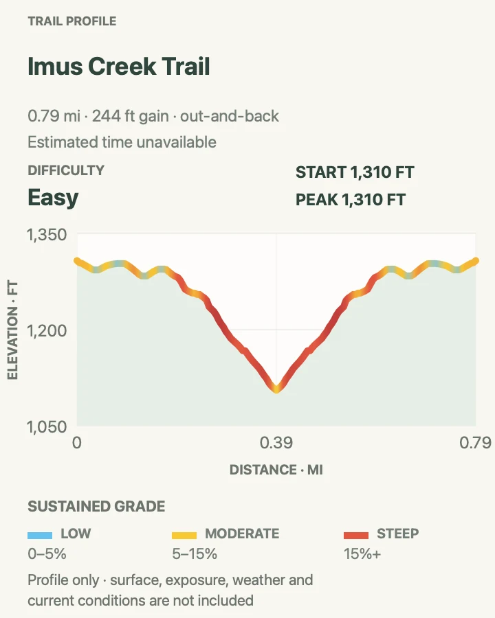
Imus Creek Trail
- Distance
- 0.8 mile round trip
- Elevation gain
- 240 feet
- Time
- Allow 30 to 60 minutes
- Difficulty
- Easy
- Route type
- Out and back
- Parking
- Start near Stehekin Landing and use designated visitor parking or arrive on foot from the ferry; keep operational access open.
- Best time
- Morning or evening in spring through fall.
- Pets
- Check current Lake Chelan National Recreation Area pet rules before arrival.
Imus Creek climbs gradually through forest above Stehekin Landing for views of the surrounding hills, peaks, and Lake Chelan. NPS describes a road connection that can complete a loop; this map keeps the named trail itself as a simple out-and-back.
The distinction avoids presenting a road segment as trail geometry. Hikers who choose the loop option should add the signed road walk and traffic awareness to the plan.
What helps on this route
- Decide between retracing and the road connection before leaving the trail.
- Use this route around ferry timing only with enough schedule margin.
Terrain and access: Short wooded trail with gradual climbing, roots, and views toward Lake Chelan and nearby peaks.

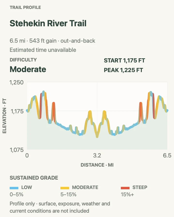
Stehekin River Trail
- Distance
- 6.4 miles round trip
- Elevation gain
- 540 feet
- Time
- Allow 3.5 to 5 hours
- Difficulty
- Moderate
- Route type
- Out and back
- Parking
- Use the signed Stehekin River trail access reached through the valley transportation system; confirm shuttle stop and return timing.
- Best time
- Spring through fall after checking river and trail conditions.
- Pets
- Check current Lake Chelan National Recreation Area pet and shuttle rules before arrival.
Stehekin River Trail follows the river corridor toward Weaver Point through a low-elevation mix of forest, ponds, and riparian habitat. It offers a quieter ecological walk than the steep passes that dominate the valley skyline.
The tread is moderate, but beaver activity, river flooding, and fallen trees can change the route after storms. Wildlife sightings are a reason to slow down, not to leave the path or approach an animal.
What helps on this route
- Confirm the trailhead transportation plan with the current Stehekin schedule.
- Give ponds and riverbanks room rather than following wildlife tracks off trail.
Terrain and access: Mostly gentle river corridor with roots, damp areas, short rises, and seasonal flood effects.

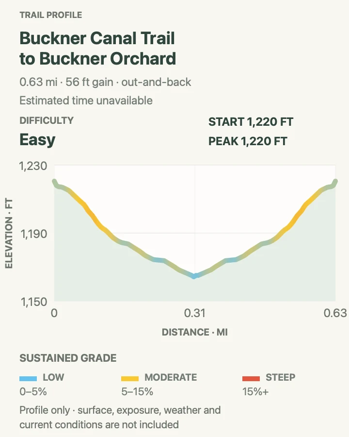
Buckner Canal Trail to Buckner Orchard
- Distance
- 0.6 mile round trip
- Elevation gain
- 55 feet
- Time
- Allow 30 to 60 minutes
- Difficulty
- Easy
- Route type
- Out and back
- Parking
- Reach the signed Buckner Orchard area using current Stehekin Valley transportation and park only in designated spaces.
- Best time
- During visitor-access hours in spring through fall.
- Pets
- Check current Lake Chelan National Recreation Area and historic-site pet rules.
This short route follows the named canal trail to the Buckner Orchard landscape. The walking is easy, but the setting is an actively managed historic district rather than an open field for shortcuts.
Stay on public paths, leave orchard equipment and structures untouched, and follow any seasonal instructions for fruit, irrigation, or buildings. Valley transport time can exceed the hike itself.
What helps on this route
- Check current orchard hours and programs before traveling up-valley.
- Keep clear of irrigation features, machinery, and private areas.
Terrain and access: Short nearly level historic canal path with uneven natural tread and managed orchard surroundings.

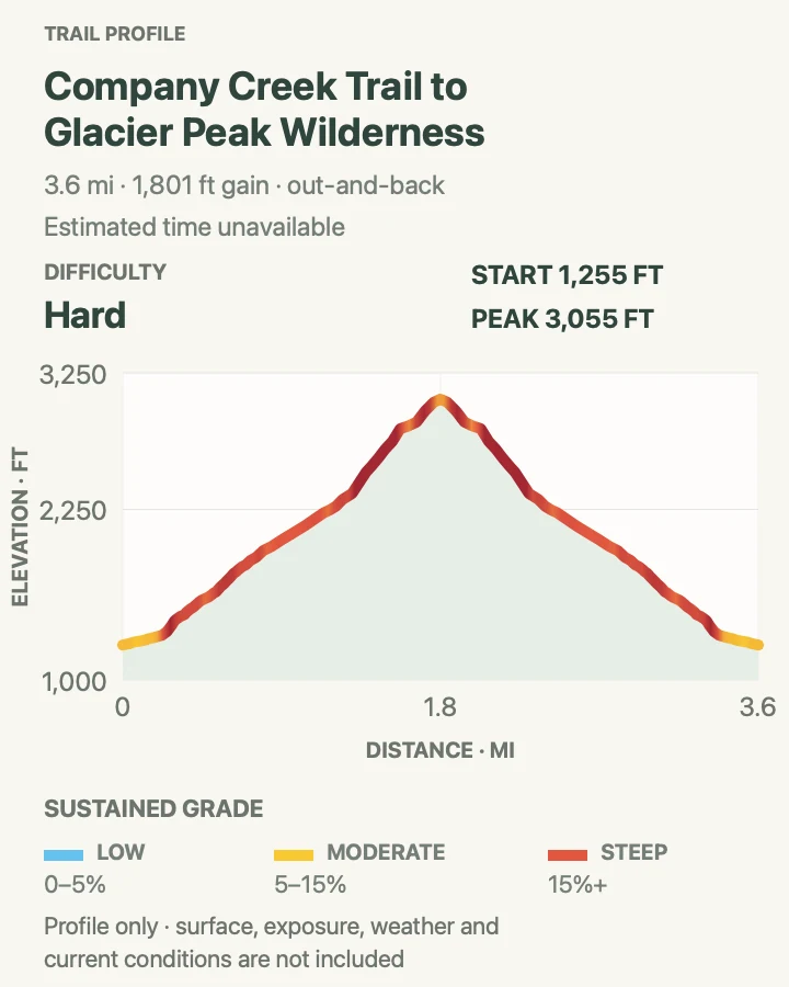
Company Creek Trail to Glacier Peak Wilderness
- Distance
- 3.6 miles round trip
- Elevation gain
- 1,800 feet
- Time
- Allow 3 to 4.5 hours
- Difficulty
- Strenuous
- Route type
- Out and back
- Parking
- Reach the signed Company Creek trailhead through the Stehekin Valley transportation system and confirm a legal return.
- Best time
- A cool snow-free day after checking brush, fire, and washout reports.
- Pets
- Check current Lake Chelan National Recreation Area and Glacier Peak Wilderness rules for the complete route.
Company Creek climbs rapidly from the Stehekin Valley toward the Glacier Peak Wilderness. This day-hike version turns at the wilderness boundary after 1.8 miles and returns, rather than implying that the longer Company Creek–Devore circuit fits inside the card.
The route gains about 1,800 feet in a short distance. Maintenance can be less frequent than on the valley's featured walks, so brush, windfall, and narrow sidehill tread may dominate the experience.
What helps on this route
- Treat the wilderness boundary as the turnaround for this route.
- Ask locally about recent clearing before relying on normal hiking pace.
Terrain and access: Steep forest sidehill, narrow tread, brush, fallen trees, and roughly 1,800 feet of measured gain.

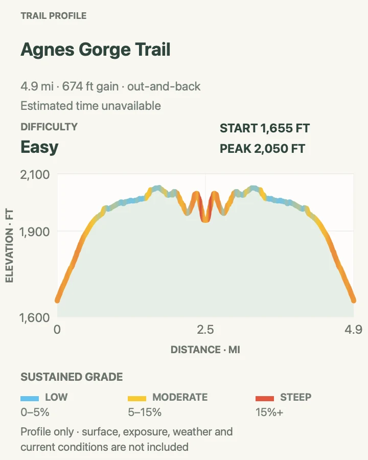
Agnes Gorge Trail
- Distance
- 5.0 miles round trip
- Elevation gain
- 670 feet
- Time
- Allow 2.5 to 4 hours
- Difficulty
- Easy
- Route type
- Out and back
- Parking
- Use the High Bridge area reached by the Stehekin Valley Shuttle or another legal valley transportation plan.
- Best time
- Spring or early summer for stronger waterfall flow, after the trail opens.
- Pets
- Check current Lake Chelan National Recreation Area pet and shuttle rules.
Agnes Gorge moves through dry slopes, small creeks, and cedar forest before Agnes Creek narrows into the gorge. Spring and early summer generally provide the strongest water display, while later conditions can be hot and dry.
The gorge is a viewing destination, not an invitation to descend to the water. Stay on the maintained endpoint and keep back from loose edges and slick rock.
What helps on this route
- Coordinate the High Bridge stop with the current shuttle schedule.
- View the gorge from established trail space and do not descend toward fast water.
Terrain and access: Dry open slopes, creek crossings, cedar forest, and a defined gorge viewpoint.

Agnes Creek Trail to Five-Mile Camp
- Distance
- 11.0 miles round trip
- Elevation gain
- 1,670 feet
- Time
- Allow 5.5 to 8 hours
- Difficulty
- Moderate
- Route type
- Out and back
- Parking
- Begin near High Bridge using the Stehekin Valley Shuttle or another legal valley transportation plan.
- Best time
- A cool snow-free day after confirming PCT and fire conditions.
- Pets
- Check current Lake Chelan National Recreation Area, national park, and Pacific Crest Trail rules for the whole route.
Agnes Creek Trail is also the southbound Pacific Crest Trail. This day hike follows it from the High Bridge area to Five-Mile Camp and returns, using a named destination instead of presenting the continent-spanning trail as an open-ended walk.
The forest and creek corridor can feel gentle, but the full out-and-back is long and accumulates more than 1,600 feet of measured gain. Current fire closures or bridge conditions can supersede the mapped line.
What helps on this route
- Check the PCT and Agnes Creek closure entry on the current conditions page.
- Use Five-Mile Camp as the turnaround even if the larger trail remains inviting.
Terrain and access: Forested river corridor with large cedars, rolling grades, bridge and fire-condition dependencies, and a fixed camp turnaround.

Purple Creek Trail to Purple Pass
- Distance
- 15.0 miles round trip
- Elevation gain
- 6,130 feet
- Time
- Allow 9 to 12 hours
- Difficulty
- Strenuous
- Route type
- Out and back
- Parking
- Start behind the Golden West Visitor Center at Stehekin Landing and keep ferry and visitor-center access clear.
- Best time
- A cool, stable snow-free day with a very early start.
- Pets
- Check current Lake Chelan National Recreation Area and national park rules for this high route.
Purple Creek begins almost at Lake Chelan and climbs relentlessly to Purple Pass. Views open across the Stehekin Valley and toward the Glacier Peak country, but they are earned through a 7.5-mile ascent that NPS rates strenuous.
NPS warns that summer water may be unavailable after the Purple Creek crossing about two miles from Stehekin until the Juanita Lake area. The route profile records more than 6,100 feet of total gain, making this the collection's largest single-day commitment.
What helps on this route
- Carry enough water to bridge the long dry section described in the current trail report.
- Boulder Butte and Juanita Lake are separate extensions and are not included in this card.
Terrain and access: Very steep sustained climbing, dry burned slopes, limited summer water, high-country snow, and more than 6,000 feet of measured gain.

Official planning sources
Trail access and safety details were checked against these National Park Service pages. The maps and profiles follow the corresponding route geometry.
Map data © OpenStreetMap contributors. Trail geometry and planning details include National Park Service public information.