12 Best Hikes in Pinnacles National Park
All twelve distinct official Pinnacles hikes, with custom terrain maps, measured elevation profiles, cave-status planning, and live park conditions.
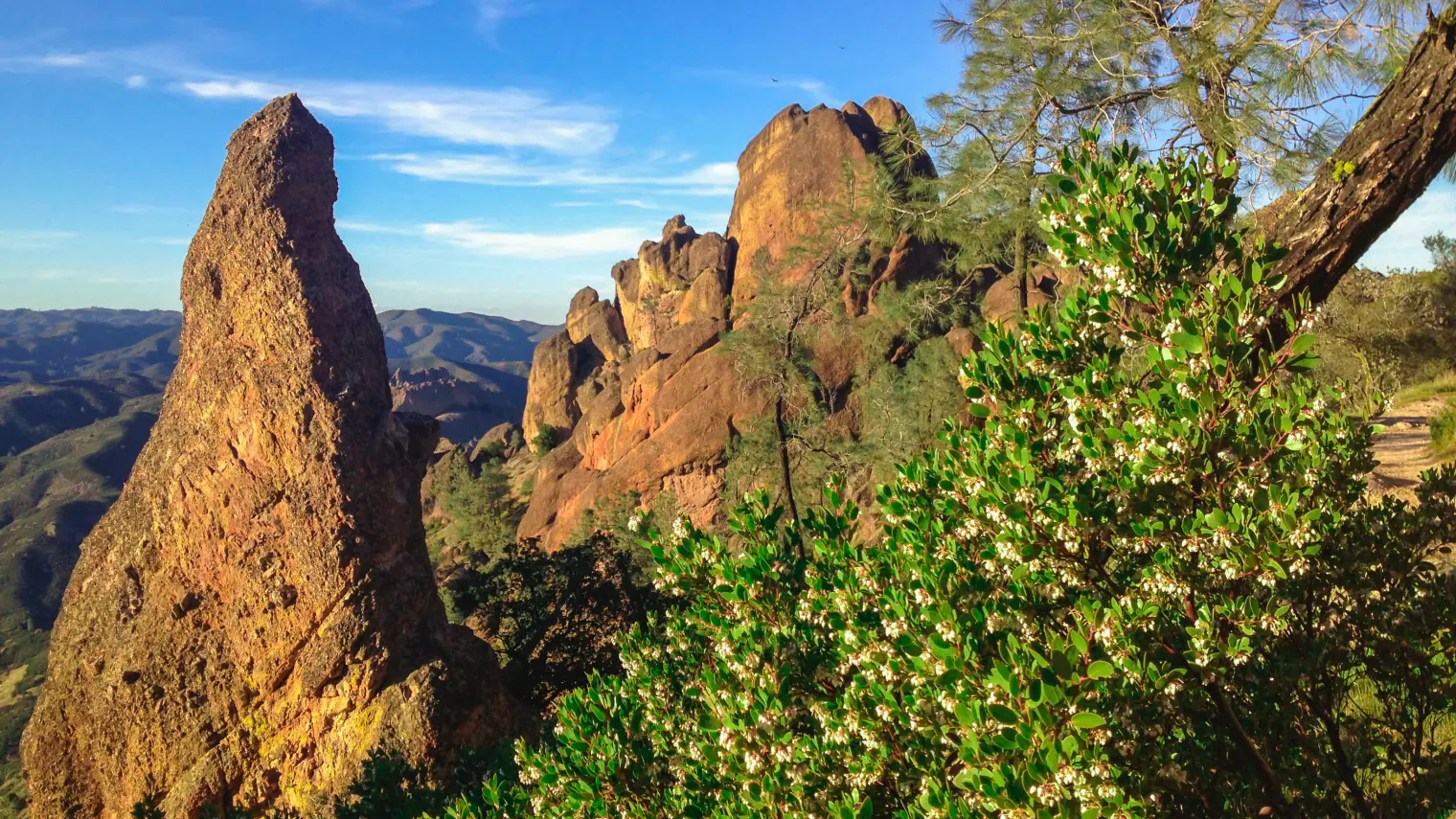
Pinnacles packs two trail systems, two talus caves, oak-and-chaparral canyons, and the exposed High Peaks into a compact volcanic landscape. The east and west entrances reach opposite sides of that landscape, but no road crosses the park. Choosing the correct entrance is part of choosing the hike.
This guide covers the twelve distinct hikes in the current official inventory. Distances and expected times follow NPS figures; elevation profiles are measured from the preserved geometry used for each map. Point-to-point routes remain point to point rather than quietly doubling their mileage, and the unmaintained wilderness routes are described as such.
Planning information was checked on August 31, 2026. At that check, the lower Bear Gulch Cave and Balconies Cave were open, while the upper Bear Gulch Cave was closed. Cave access can change for bats, flooding, rockfall, vandalism, or emergency work, so use the live alert panel and official cave-status page before leaving. Any gate, closure, ranger direction, or field condition overrides this guide and its mapped line.
Live park weather
Pinnacles National Park
Bear Gulch Nature Center, east side
Loading the latest conditions and alerts…
What changes a hiking day here
Choose east or west before the drive
Pinnacles has no through road. The east entrance serves the campground, Bear Gulch, Condor Gulch, the reservoir, and Chalone Peak; the west entrance serves Prewett Point, Chaparral, Balconies, Juniper Canyon, and North Wilderness. Driving between entrances requires leaving the park and routing through King City, so do not build a day that assumes a quick cross-park transfer.
Treat cave status as a live variable
Bear Gulch and Balconies are talus caves rather than developed show caves. Bring a headlamp or flashlight, expect low ceilings and uneven rock, and never enter past a closure. Bear Gulch sections open and close around Townsend's big-eared bat use; both caves can also close or become unsafe after flooding, rockfall, or other damage.
Carry the water you will need
NPS advises at least one liter per person per hour in hot weather. Drinking water is limited to developed areas, not trail corridors, and summer or early-fall temperatures can rise above 100°F. Start long routes early, use sun protection, and turn around before the remaining water becomes a rescue problem.
Read unmaintained literally
South Wilderness and North Wilderness receive no ordinary maintained-trail treatment. North Wilderness in particular uses ridges, cairns, faint tread, and remote country where navigation and self-rescue matter. Carry the official map plus an offline copy, leave a route plan with someone, and choose a maintained alternative after storms or when the line is unclear.
Use the High Peaks railings with care
Juniper Canyon and the High Peaks-Bear Gulch circuit reach the Steep and Narrow section, where carved steps, handrails, exposure, and opposing traffic demand patience. These are not good places to rush around another party. Turn back for ice, lightning, severe wind, or any condition that makes secure movement uncertain.
Expect water to outlast the rain
Old Pinnacles, both wilderness routes, Chalone Peak, Balconies, and Bear Gulch can become difficult or impassable during wet weather, and streams may continue rising after rain stops. Do not use a mapped crossing as evidence that today's crossing is safe. Rock and tree fall can also increase after storms or in high wind.
Leave pets out of the trail plan
Pets are prohibited on every park trail. They may be in the campground, picnic areas, parking areas, and on paved roads when physically controlled on a leash no longer than six feet. Never leave an animal unattended in a hot vehicle; trained service animals follow separate federal rules.
| Trail | Distance | Time | Difficulty | Best for |
|---|---|---|---|---|
| Prewett Point Trail | 0.9 mile round trip | About 30 minutes to 1 hour | Easy | A short west-side overview |
| Jawbone Trail | 1.2 miles one way | About 30 minutes to 1 hour one way | Easy to moderate | A west-side connector with open rock views |
| Balconies Cliffs-Cave Loop | 2.4 miles loop | About 1 to 1.5 hours | Easy to moderate | A compact talus-cave and cliff circuit |
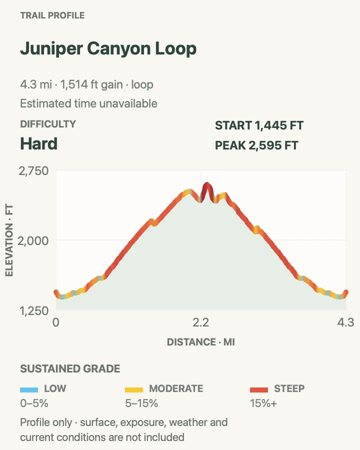
| Juniper Canyon Loop | 4.3 miles loop | About 2 to 3 hours | Strenuous | A west-side climb into the High Peaks |
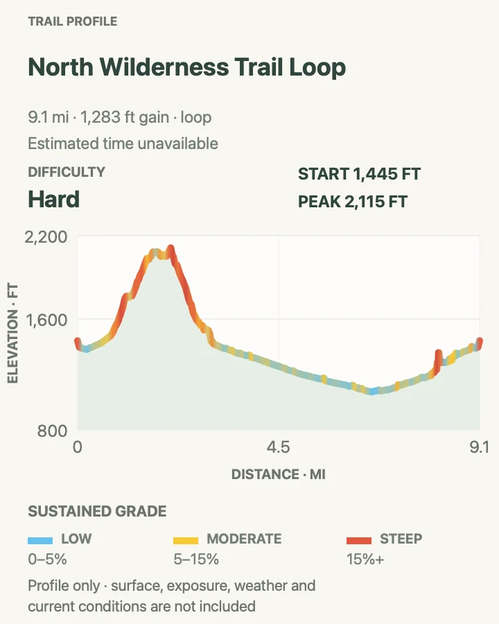
| North Wilderness Trail Loop | 9.3 miles loop | About 5 to 8 hours | Strenuous | Remote unmaintained wilderness travel |
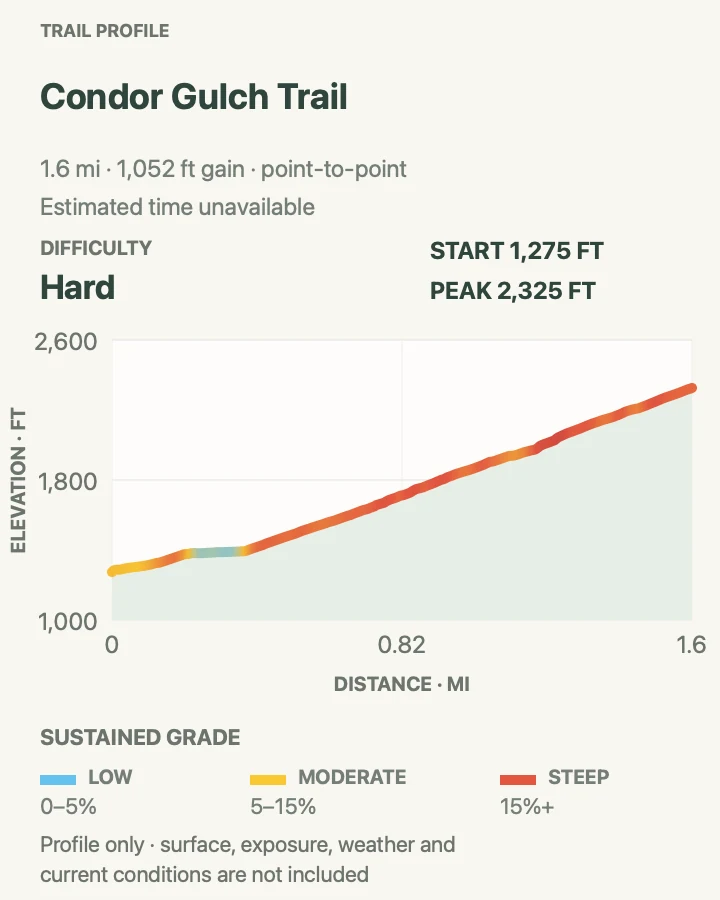
| Condor Gulch Trail | 1.7 miles one way | About 1 to 1.5 hours one way | Moderate to strenuous | A direct climb toward the High Peaks |
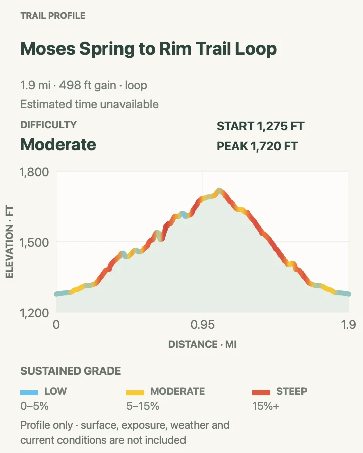
| Moses Spring to Rim Trail Loop | 2.2 miles loop | About 1 to 1.5 hours | Moderate | Reservoir, rock formations, and a short cave option |
| High Peaks to Bear Gulch Loop | 6.7 miles loop | About 4 to 5 hours | Strenuous | The complete east-side High Peaks circuit |
| Chalone Peak Trail | 9.0 miles round trip | About 3 to 5 hours | Strenuous | The park's high summit viewpoint |
| Campground to Bear Gulch Day Use Area | 2.3 miles one way | About 1.5 hours one way | Moderate | A creek-side east-side connector |
| Campground to Balconies Cave | 9.4 miles round trip | About 4 to 6 hours | Moderate | A long low-elevation approach to Balconies |
| Campground to South Wilderness Trail | 6.5 miles round trip | About 3 to 4 hours | Moderate | A quiet valley-oak wilderness walk |
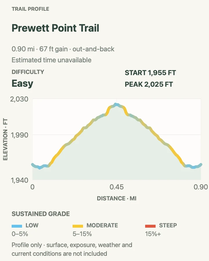
Prewett Point Trail
- Distance
- 0.9 mile round trip
- Elevation gain
- 65 feet
- Time
- About 30 minutes to 1 hour
- Difficulty
- Easy
- Route type
- Out and back
- Parking
- Start at the West Pinnacles Visitor Contact Station and confirm the west-entrance road and lot are open.
- Best time
- A cool clear morning or late afternoon before the west side heats up.
- Pets
- Pets are prohibited on this trail.
Prewett Point begins gently beside the west contact station and climbs only about seventy feet to broad views into the Hain Wilderness. Its compact distance makes it useful for learning the west-side terrain before committing to Chaparral's cave or High Peaks routes.
The viewpoint is exposed despite the easy grade. Carry water, keep children close at the overlook, and do not extend the walk onto an unsigned slope simply because the official trail ends quickly.
What helps on this route
- Ask at the contact station about Chaparral parking before driving farther in.
- Use the overlook to identify the High Peaks and the west-side trail corridors.
Terrain and access: Gentle maintained tread with roughly seventy feet of change and an exposed viewpoint.

Jawbone Trail
- Distance
- 1.2 miles one way
- Elevation gain
- 0 feet
- Time
- About 30 minutes to 1 hour one way
- Difficulty
- Easy to moderate
- Route type
- Point to point
- Parking
- Begin at the West Pinnacles Visitor Contact Station or arrange the route from Jawbone Parking Area; do not assume a return shuttle.
- Best time
- A cool morning when a return walk or vehicle arrangement is already settled.
- Pets
- Pets are prohibited on this trail.
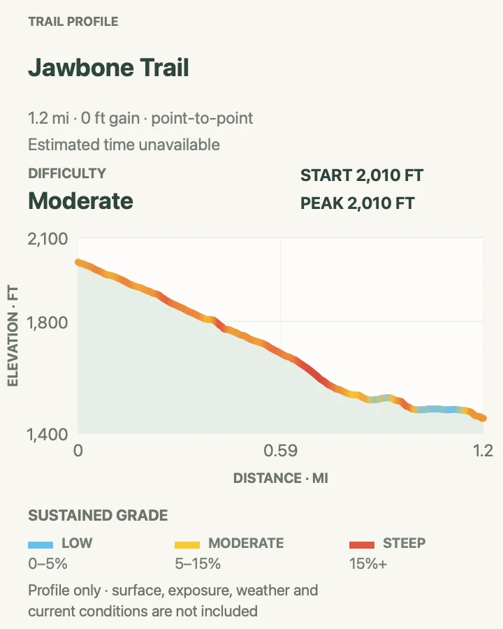
Jawbone descends from the west contact station toward Jawbone Parking Area, losing about 560 feet along the signed connector. The map and profile preserve that one-way direction rather than presenting the descent as a round trip.
A one-way trail still needs a return plan. Without a second vehicle or confirmed pickup, reverse the route and budget another 1.2 miles plus the climb back to the contact station; do not count on an informal shuttle.
What helps on this route
- Keep enough water and time for an uphill return if plans change.
- Confirm which lot your vehicle is in before descending.
Terrain and access: Sustained west-side descent on rocky, exposed tread; the reverse direction is a steady climb.

Balconies Cliffs-Cave Loop
- Distance
- 2.4 miles loop
- Elevation gain
- 560 feet
- Time
- About 1 to 1.5 hours
- Difficulty
- Easy to moderate
- Route type
- Loop
- Parking
- Use the Chaparral parking area inside the west entrance; check lot availability and cave status before starting.
- Best time
- A dry cool morning when Balconies Cave is confirmed open.
- Pets
- Pets are prohibited on this trail.
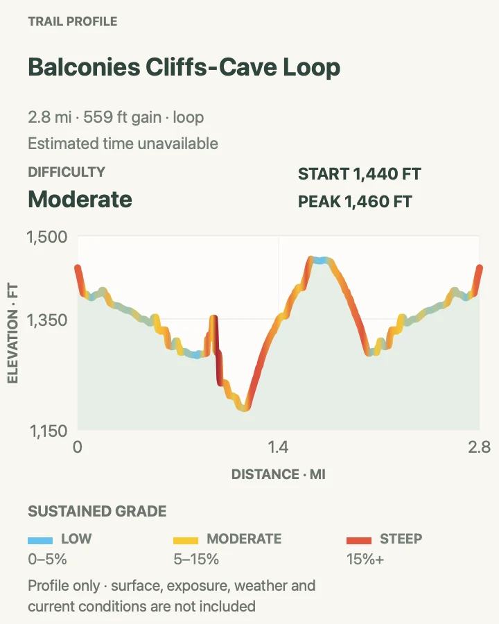
From Chaparral, this loop pairs the Balconies Cliffs Trail with the boulder-filled cave passage below Machete Ridge. The two halves are deliberately different: one gives open views of the formation, while the other requires careful movement through dim, uneven rock.
Carry a real light source and expect hands-on balance in places. Floodwater, rockfall, or an official closure can remove the cave half; when that happens, use only the signed open trail and never climb around a gate or barricade to preserve the loop.
What helps on this route
- Pack a headlamp for every member of the group.
- Avoid touching stinging nettle near the cave entrance and watch for poison oak along the corridor.
Terrain and access: Rocky maintained trail, exposed cliff-side tread, low talus-cave passages, and uneven scrambling surfaces.

Juniper Canyon Loop
- Distance
- 4.3 miles loop
- Elevation gain
- 1,510 feet
- Time
- About 2 to 3 hours
- Difficulty
- Strenuous
- Route type
- Loop
- Parking
- Start at Chaparral on the west side; parking can fill, so confirm access before committing to the one-lane approach road.
- Best time
- Early on a cool, dry, low-wind day.
- Pets
- Pets are prohibited on this trail.
Juniper Canyon climbs tight switchbacks from Chaparral into the rock formations, then uses the High Peaks and Tunnel corridors to complete the circuit. The measured profile records roughly 1,500 feet of cumulative ascent, slightly more than the net figure implied by a simple trailhead-to-high-point comparison.
The Steep and Narrow section uses steps and handrails on exposed rock. Move one party at a time where space is limited, keep both hands available, and retreat rather than pressing through lightning, ice, or wind that compromises balance.
What helps on this route
- Carry gloves only if they improve your grip; never rely on them in place of secure hand placement.
- Save water for the exposed descent into Chaparral.
Terrain and access: Steep switchbacks, rocky High Peaks tread, a tunnel, carved steps, handrails, and significant exposure.

North Wilderness Trail Loop
- Distance
- 9.3 miles loop
- Elevation gain
- 1,280 feet
- Time
- About 5 to 8 hours
- Difficulty
- Strenuous
- Route type
- Loop
- Parking
- Use Chaparral on the west side and leave a route plan with someone who is not on the hike.
- Best time
- A cool dry day with stable weather, strong navigation skills, and ample daylight.
- Pets
- Pets are prohibited on this trail.
North Wilderness leaves the maintained Balconies system for faint tread, ridgelines, and cairn-marked country before circling back toward Chaparral. NPS identifies it as unmaintained; the label is a warning about navigation, brush, erosion, and self-reliance rather than a promise of a continuously obvious path.
The route is a poor choice after heavy rain, in high heat, or for a first Pinnacles hike. Carry the official map and an offline map, track progress against daylight and water, and turn around early if cairns or tread stop matching the defensible route.
What helps on this route
- Do not build navigation around cell coverage; service is limited.
- Wear clothing that limits contact with poison oak and inspect for ticks afterward.
Terrain and access: Long unmaintained loop with faint tread, ridges, cairns, brush, rocky slopes, and remote sections.

Condor Gulch Trail
- Distance
- 1.7 miles one way
- Elevation gain
- 1,050 feet
- Time
- About 1 to 1.5 hours one way
- Difficulty
- Moderate to strenuous
- Route type
- Point to point
- Parking
- Begin at Bear Gulch Day Use Area on the east side; confirm parking and any internal access restrictions.
- Best time
- Morning, before heat and while rising air may bring soaring birds into view.
- Pets
- Pets are prohibited on this trail.
Condor Gulch climbs from Bear Gulch toward the High Peaks, gaining about 1,100 feet in 1.7 miles. An early overlook provides a useful stopping point, while the full one-way route continues to the High Peaks junction and needs either a planned connection or a return on the same trail.
California condors may appear overhead, but sightings are never guaranteed. Watch without approaching roosting birds, keep food secured, and never leave small litter or microtrash that wildlife can ingest.
What helps on this route
- If returning the same way, budget 3.4 miles total rather than the one-way figure.
- Use binoculars instead of leaving the trail for a closer wildlife view.
Terrain and access: Sustained exposed climb on switchbacks and rocky tread with about 1,100 feet of gain.

Moses Spring to Rim Trail Loop
- Distance
- 2.2 miles loop
- Elevation gain
- 500 feet
- Time
- About 1 to 1.5 hours
- Difficulty
- Moderate
- Route type
- Loop
- Parking
- Use Bear Gulch Day Use Area on the east side and check the current Bear Gulch Cave status before leaving the lot.
- Best time
- A cool morning when the intended cave section is open and free of flood concerns.
- Pets
- Pets are prohibited on this trail.
Moses Spring and Rim Trail make a compact circuit through Bear Gulch formations to the reservoir. The lower cave can be part of the route when open; the signed Moses Spring bypass preserves a legal alternative when bat protection, flooding, or another closure removes cave access.
The official two-mile scale hides close rock, steps, and roughly five hundred feet of cumulative ascent. Carry a headlamp even if the online status says open, and follow the day's signs at every cave junction rather than forcing the map's preferred line.
What helps on this route
- Check the cave-status page again on the morning of the hike.
- Keep food packed away at the reservoir and do not enter closed upper-cave habitat.
Terrain and access: Rocky canyon trail, steps, cave or bypass options, and a moderate climb to the reservoir and rim.

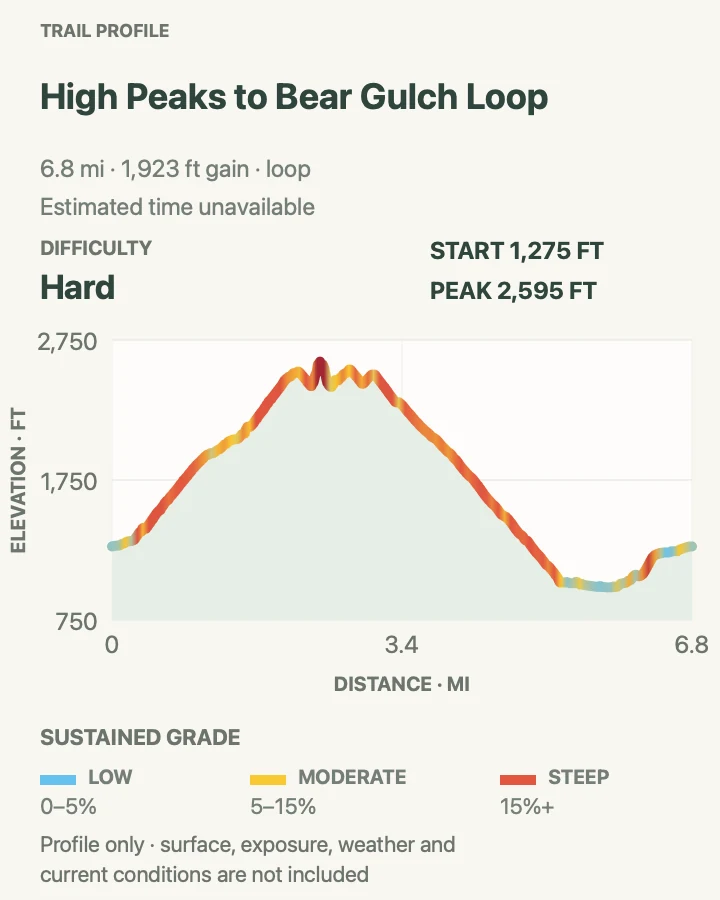
High Peaks to Bear Gulch Loop
- Distance
- 6.7 miles loop
- Elevation gain
- 1,920 feet
- Time
- About 4 to 5 hours
- Difficulty
- Strenuous
- Route type
- Loop
- Parking
- Start at Bear Gulch Day Use Area on the east side; arrive with an alternative if the lot or internal road is unavailable.
- Best time
- Early on a cool, dry day with no lightning or high-wind threat.
- Pets
- Pets are prohibited on this trail.
This loop climbs Condor Gulch, traverses the High Peaks and Steep and Narrow section, then descends through oak woodland toward Bear Gulch. It covers the major east-side elevation zones without adding the substantially overlapping Condor Gulch-High Peaks variant as a separate hike.
The measured geometry produces about 1,900 feet of cumulative ascent, so plan for more work than a single published net-gain figure suggests. Exposure, narrow steps, railings, and opposing traffic can slow the traverse; daylight and water reserves should allow for that delay.
What helps on this route
- Travel the exposed High Peaks section before afternoon heat or storms build.
- Step aside only at secure wide places and never pass outside a railing.
Terrain and access: Long steep circuit with switchbacks, exposed High Peaks rock, carved steps, railings, and a woodland descent.

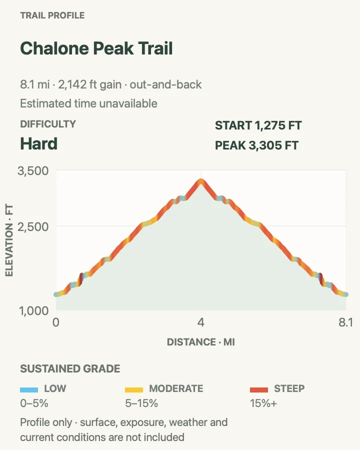
Chalone Peak Trail
- Distance
- 9.0 miles round trip
- Elevation gain
- 2,140 feet
- Time
- About 3 to 5 hours
- Difficulty
- Strenuous
- Route type
- Out and back
- Parking
- Begin at Bear Gulch Day Use Area and follow the reservoir approach to the signed North Chalone Peak route.
- Best time
- A cool clear morning with enough water for an exposed summit climb.
- Pets
- Pets are prohibited on this trail.
Chalone Peak continues beyond the Bear Gulch reservoir into a long, exposed ascent to North Chalone Peak. The preserved route measures a little over eight miles, while NPS publishes nine miles round trip; this guide uses the official planning distance and keeps the profile tied to the actual mapped geometry.
North Chalone is the maintained destination. The path toward South Chalone is unmaintained and is not folded into this route or described as a required extension. Heat, wind, wet crossings, and limited water are stronger decision points than reaching a summit at any cost.
What helps on this route
- Carry more water than the reservoir approach alone seems to require.
- Turn around below the summit for lightning, severe wind, or a shrinking daylight margin.
Terrain and access: Long exposed out-and-back with more than 2,000 feet of cumulative ascent and a high open summit.

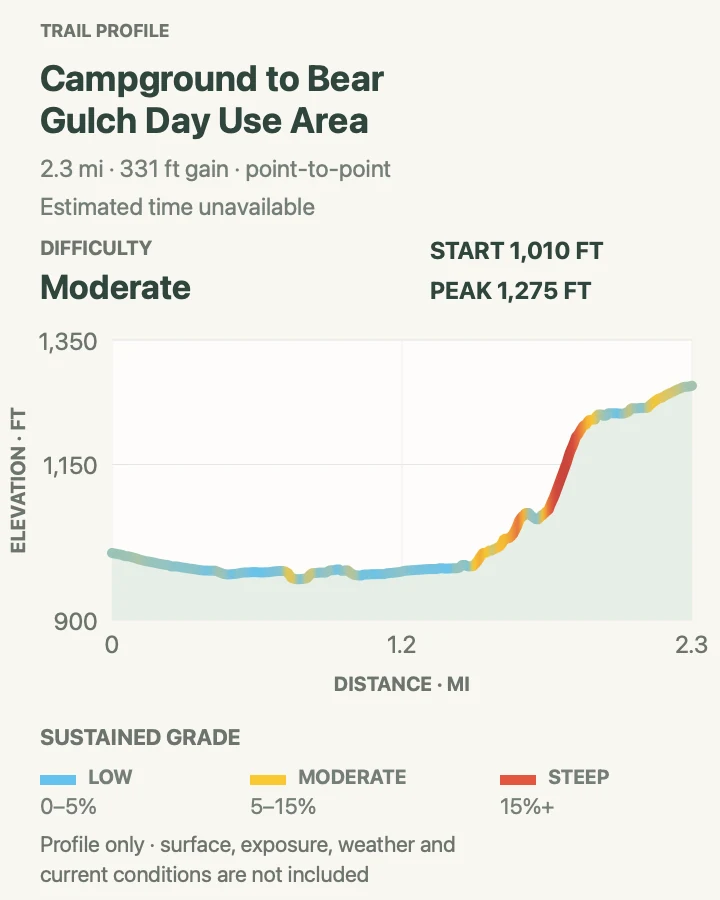
Campground to Bear Gulch Day Use Area
- Distance
- 2.3 miles one way
- Elevation gain
- 330 feet
- Time
- About 1.5 hours one way
- Difficulty
- Moderate
- Route type
- Point to point
- Parking
- Start at Pinnacles Campground on the east side or arrange the reverse from Bear Gulch Day Use Area; do not assume a shuttle.
- Best time
- A cool morning with a firm return or pickup plan.
- Pets
- Pets are prohibited on this trail.
This lower-elevation route follows Bear and Chalone creeks between the campground and Bear Gulch Day Use Area. Riparian shade and bird habitat distinguish it from the exposed High Peaks, but the one-way format means the published 2.3 miles is only half of an unsupported out-and-back.
Arrange the return before leaving either endpoint. If no vehicle or confirmed service is available, budget 4.6 miles and enough water for the walk back; current road access never guarantees a ride between the trailheads.
What helps on this route
- Protect food and small items around wildlife-rich creek habitat.
- Expect muddy or rising crossings after rain and turn back when water is unsafe.
Terrain and access: Rolling creek-side trail with roughly 300 feet of net change, riparian shade, and seasonal wet crossings.

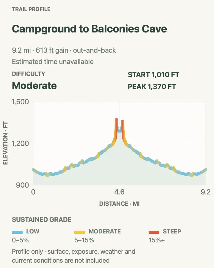
Campground to Balconies Cave
- Distance
- 9.4 miles round trip
- Elevation gain
- 610 feet
- Time
- About 4 to 6 hours
- Difficulty
- Moderate
- Route type
- Out and back
- Parking
- Start at Pinnacles Campground on the east side and verify campground access plus Balconies Cave status.
- Best time
- An early, cool, dry day when the cave is confirmed open.
- Pets
- Pets are prohibited on this trail.
From the campground, this route follows the lower corridor toward Old Pinnacles and continues beneath Machete Ridge to Balconies Cave. It earns its place as the full east-side approach; the shorter Old Pinnacles version is omitted because it repeats the same destination and most of the same corridor.
Carry a headlamp and treat the cave as conditional. If flooding, rockfall, or a closure blocks passage, turn around or use only a signed open alternative. Long sunny grassland sections and the return mileage make water management more important than the moderate rating suggests.
What helps on this route
- Confirm that every hiker's light works before leaving the campground.
- Set a cave turnaround time that preserves daylight and water for the full return.
Terrain and access: Long rolling creek-and-grassland approach with rocky cliff sections, seasonal crossings, and optional talus-cave passage.

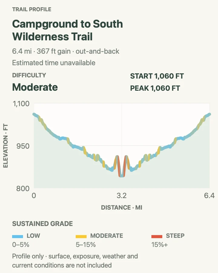
Campground to South Wilderness Trail
- Distance
- 6.5 miles round trip
- Elevation gain
- 370 feet
- Time
- About 3 to 4 hours
- Difficulty
- Moderate
- Route type
- Out and back
- Parking
- Begin at Pinnacles Campground on the east side and check current conditions for the unmaintained South Wilderness corridor.
- Best time
- A cool dry morning, avoiding high water and peak summer heat.
- Pets
- Pets are prohibited on this trail.
South Wilderness follows a lower, quieter corridor beneath mature valley oaks. NPS publishes no net elevation gain, but the measured profile still records small cumulative rises and dips; flat on paper does not mean paved, maintained, or free of route-finding decisions.
This trail is unmaintained and can become difficult during wet weather. Brush, poison oak, creek conditions, and faint tread should determine the turnaround. Do not push past an unclear line merely to reach the mileage printed in the inventory.
What helps on this route
- Carry an offline map and note the exact campground return junction.
- Wear long clothing where it helps avoid poison oak and check for ticks after the hike.
Terrain and access: Low-gradient unmaintained out-and-back with oak woodland, brush, seasonal wet areas, and faint tread.

Official planning sources
Trail access and safety details were checked against these National Park Service pages. The maps and profiles follow the corresponding route geometry.
Map data © OpenStreetMap contributors. Trail geometry and planning details include National Park Service public information.