13 Best Hikes in Mesa Verde National Park
All thirteen designated Mesa Verde hiking routes, with custom terrain maps, measured elevation profiles, current access notes, and live park conditions.
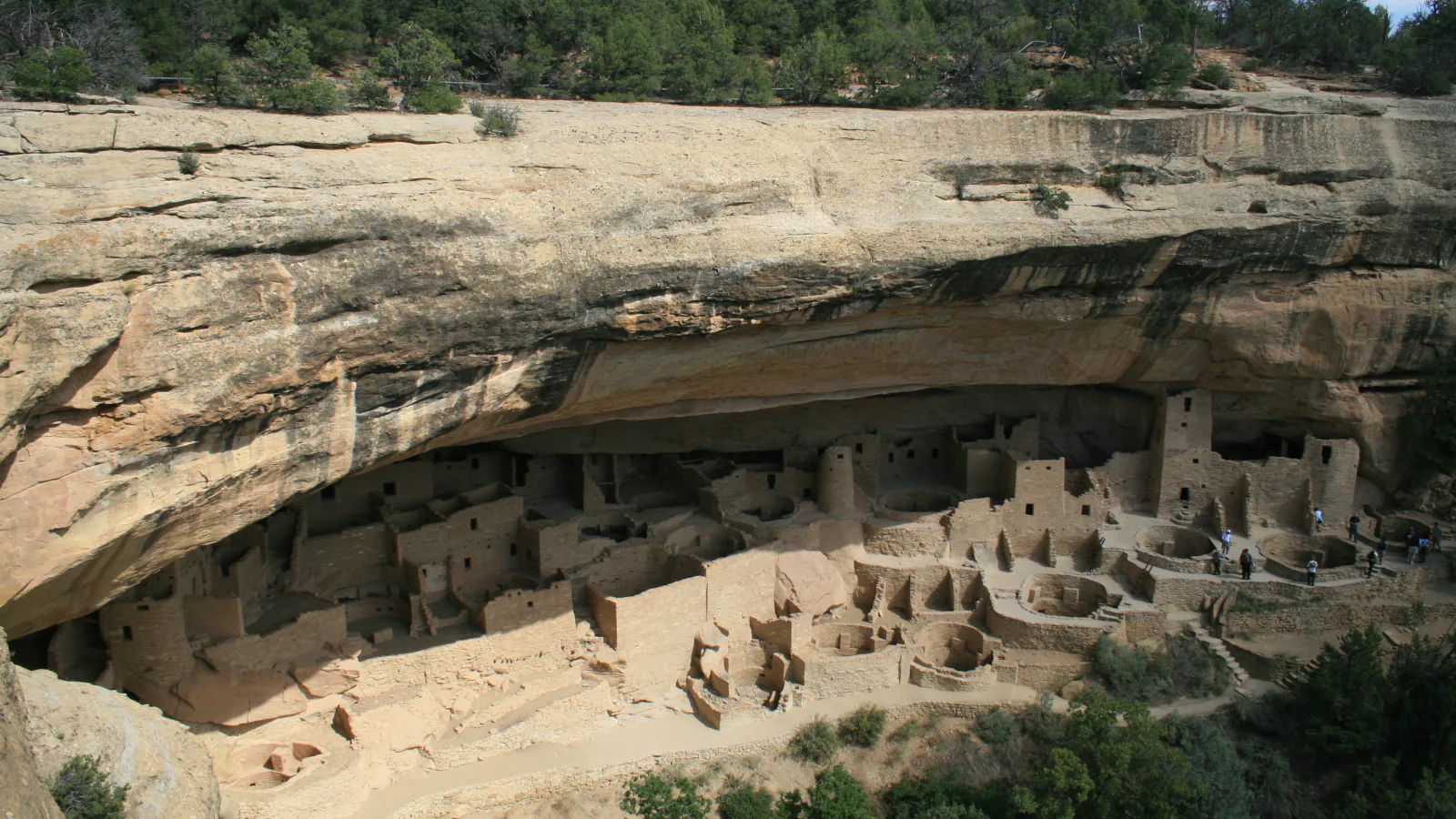
Mesa Verde is not an open backcountry park. Its mesas, canyons, dwellings, and archeological landscapes form an ancestral home sacred to twenty-seven affiliated tribes, and hiking is legal only on designated trails. The official list is finite: thirteen routes across Morefield Canyon, Chapin Mesa, Park Point, Far View, and seasonal Wetherill Mesa.
That compact inventory is unusually varied. A paved climb reaches the park's highest point; rugged canyon loops demand scrambling judgment; mesa-top paths connect ancestral communities and overlooks; and three longer Morefield routes trade cliff dwellings for forest, ridge, and valley views. Distances are the NPS-published figures, while each elevation profile is measured from the preserved geometry behind its map.
Planning information was checked on August 31, 2026. At that check, construction had temporarily closed the access roads to Far View Sites and Cedar Tree Tower, and Wetherill Mesa was operating on a seasonal gate schedule. Read the live alert and weather panels and check the official conditions page before driving. A closure, gate, posted sign, or ranger direction always overrides this guide and its mapped line.
Live park weather
Mesa Verde National Park
Mesa Verde Museum
Loading the latest conditions and alerts…
What changes a hiking day here
Treat the designated trail as the boundary
Off-trail hiking is illegal throughout Mesa Verde, and the backcountry is closed to general public use. Stay on signed tread, never enter an archeological site unless the park has opened it for that purpose, and leave pottery fragments, stone, plants, and every other cultural or natural object where it is.
Check the road before choosing a district
The park road is long and the trail groups are far apart. Morefield is near the entrance; Chapin Mesa and Cliff Palace Loop are much deeper; Wetherill Mesa requires a separate seasonal drive with a controlled gate. Temporary construction, snow, fire operations, and staffing can remove access even when the main entrance is open.
Build Wetherill Mesa around the exit deadline
For the 2026 season, NPS lists Wetherill Mesa as open May 22 through October 21, with entry beginning at 8:30 a.m., last entry at 2 p.m., and all visitors out by the 4 p.m. gate closure. Step House has narrower staffed hours, and Long House entry requires a separate ranger-led tour reservation. Verify the day's operation before committing to a long loop.
Plan for altitude, sun, and lightning
Most activity occurs above 7,000 feet, and Park Point reaches 8,572 feet. The air is dry, exposed Wetherill Mesa has little shade, and summer storms often bring lightning. Acclimatize, carry water, use sun protection, and leave rims, overlooks, and open mesa tops when thunder or building storms approach.
Keep the rugged loops honest
Petroglyph Point includes narrow ledges, loose rock, stone steps, steep edges, and a required scramble; NPS recommends traveling counterclockwise. Spruce Canyon makes a steep descent and climb. Neither route is a shortcut into Spruce Tree House, which remains closed because of rockfall danger.
Use the exact pet rule for the exact trail
Pets are prohibited on most park trails. On Wetherill Mesa, leashed pets are permitted on Nordenskiöld Site #16, Badger House Community, and Long House Loop, but not on the trails into Step House or Long House. Heat and pavement can be hazardous, and animals may never be left tethered or unattended.
Read maps as planning tools, not permission
Custom maps show defensible route geometry and measured terrain, but they cannot show today's rockfall, snow, lightning, construction, or staffing decision. Download the mobile map before leaving reliable service, then follow current signs and turn around at any closure rather than trying to complete the drawn line.
| Trail | Distance | Time | Difficulty | Best for |
|---|---|---|---|---|
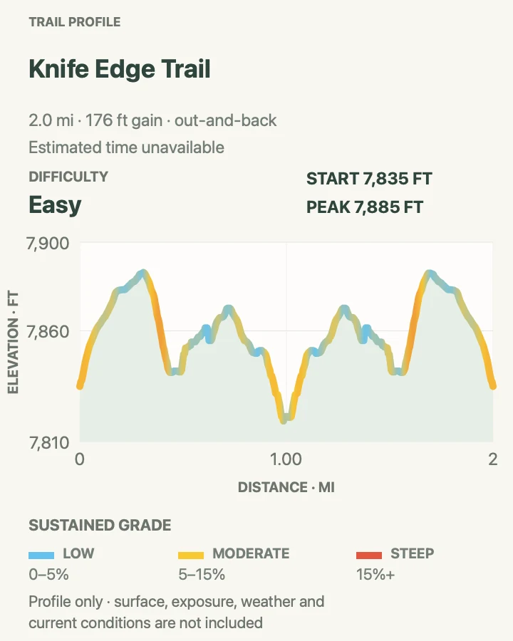
| Knife Edge Trail | 2.0 miles round trip | About 1 to 1.5 hours | Easy | Historic road grade and northwest views |
| Point Lookout Trail | 2.2 miles round trip | Varies by pace and conditions | Moderate | A compact climb to broad valley views |
| Prater Ridge Trail | 7.8 miles for both loops | Allow about 4 hours | Hard | Mesa-edge mileage and a sustained Morefield climb |
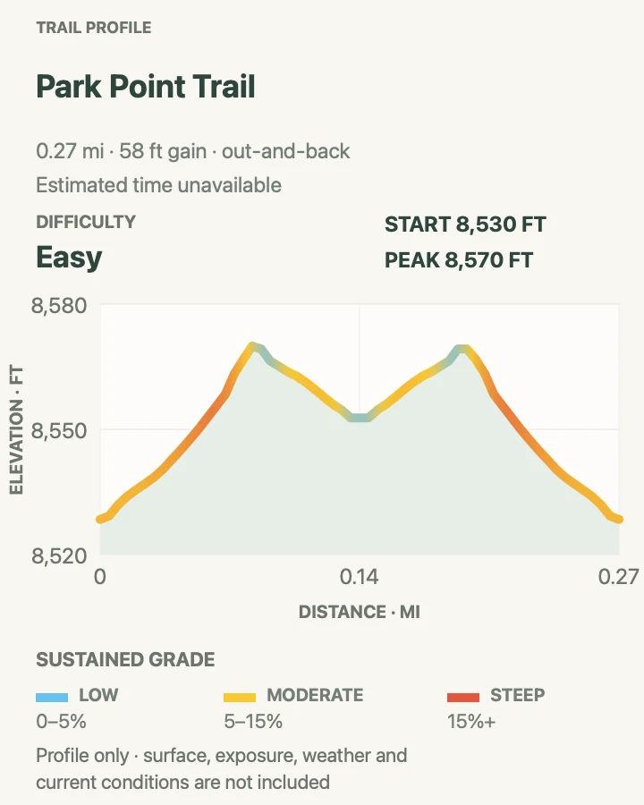
| Park Point Trail | 0.3 mile round trip | About 20 to 30 minutes | Easy | The park's highest viewpoint |
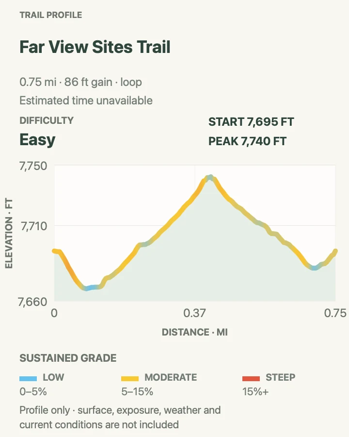
| Far View Sites Trail | 0.75 mile loop | Varies by interpretive stops | Easy | A self-guided mesa-top community walk |
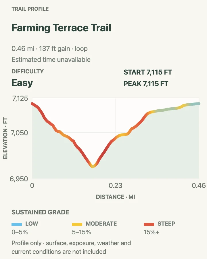
| Farming Terrace Trail | 0.5 mile round trip | About 45 to 60 minutes | Easy | A close look at ancestral water-and-soil management |
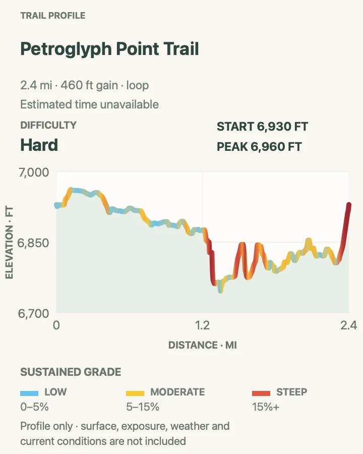
| Petroglyph Point Trail | 2.4 miles loop | About 1.5 to 3 hours | Hard | A rugged canyon traverse to a petroglyph panel |
| Spruce Canyon Trail | 2.4 miles loop | About 1.5 to 2 hours | Hard | A steep descent into a shaded canyon ecosystem |
| Soda Canyon Overlook Trail | 1.2 miles round trip | Varies by overlook stops | Easy | Balcony House views without entering a dwelling |
| Step House Trail | 1.0 mile loop | Allow about 45 minutes | Moderate | A self-guided cliff-dwelling visit with two occupation periods |
| Nordenskiöld Site #16 Trail | 2.0 miles round trip | Varies by pace and overlook stop | Moderate | A quiet cliff-dwelling overlook on Wetherill Mesa |
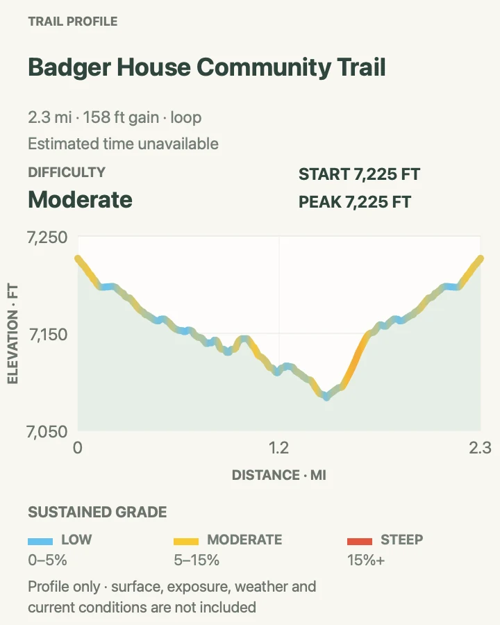
| Badger House Community Trail | 2.25 miles round trip | Varies by interpretive stops | Moderate | Six centuries of mesa-top community history |
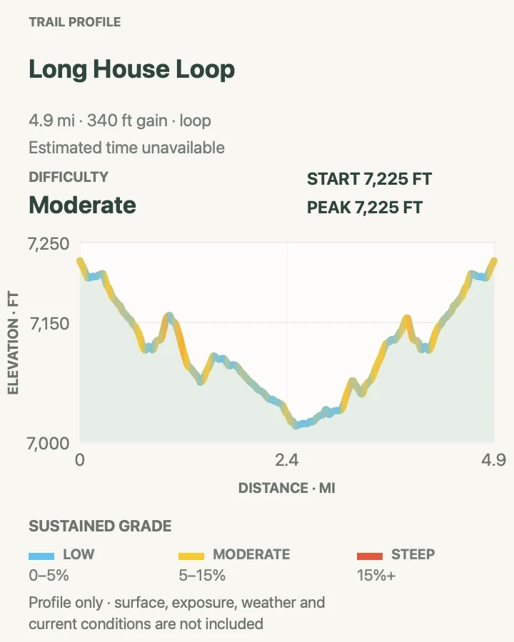
| Long House Loop | 5.0 miles loop | Varies by overlooks and side stops | Moderate | A paved walking or biking circuit among Wetherill overlooks |
Knife Edge Trail
- Distance
- 2.0 miles round trip
- Elevation gain
- 180 feet
- Time
- About 1 to 1.5 hours
- Difficulty
- Easy
- Route type
- Out and back
- Parking
- Begin in Morefield Campground and use the signed Knife Edge trail access; campground services and road access are seasonal.
- Best time
- A cool morning or sunset window after confirming the current rockfall closure boundary.
- Pets
- Pets are prohibited on this trail.
Knife Edge follows a retired segment of the park's 1914 entrance road along the north escarpment. The grade is gentle and the open northwest aspect gives this short Morefield walk a different character from the canyon routes deeper in the park.
A serious rockfall affects the final quarter of the trail, and NPS explicitly tells hikers not to enter the rockfall area. Treat the current barricade or sign as the turnaround even if the map continues; the published two-mile distance does not grant access through a closure.
What helps on this route
- Ask about the active turnaround before leaving Morefield.
- Carry a light if timing the legal open section near sunset.
Terrain and access: Mostly gentle historic road bench with exposed slopes, loose rock near the closed end, and little shade.

Point Lookout Trail
- Distance
- 2.2 miles round trip
- Elevation gain
- 520 feet
- Time
- Varies by pace and conditions
- Difficulty
- Moderate
- Route type
- Out and back
- Parking
- Use the signed Point Lookout trailhead area in Morefield Campground; confirm seasonal campground-road access.
- Best time
- A cool clear morning, before exposed switchbacks heat up or storms form.
- Pets
- Pets are prohibited on this trail.
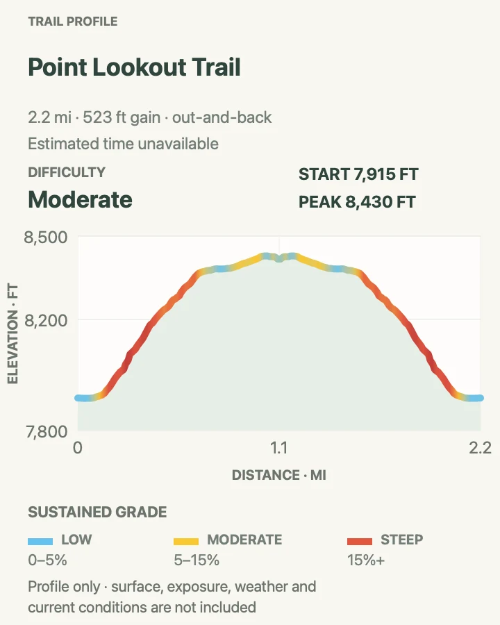
Point Lookout climbs from Morefield Canyon in a tight series of switchbacks to the flat-topped formation seen from the park entrance. The summit area opens views toward the San Juan and La Plata mountains and across the Mancos and Montezuma valleys.
The four-hundred-foot climb is concentrated, and the descent repeats the same loose, exposed turns. Stay on the built switchbacks rather than cutting corners; shortcuts damage the slope and place hikers below in the path of falling stone.
What helps on this route
- Save water for the exposed descent.
- Give uphill hikers room at narrow switchback corners.
Terrain and access: Steep switchbacks on rocky, exposed tread followed by a flatter mesa-top viewpoint area.

Prater Ridge Trail
- Distance
- 7.8 miles for both loops
- Elevation gain
- 1,190 feet
- Time
- Allow about 4 hours
- Difficulty
- Hard
- Route type
- Loop
- Parking
- Start from the signed Prater Ridge trailhead in Morefield Campground and verify seasonal access.
- Best time
- Early on a cool, stable day with enough time for both ridge loops.
- Pets
- Pets are prohibited on this trail.
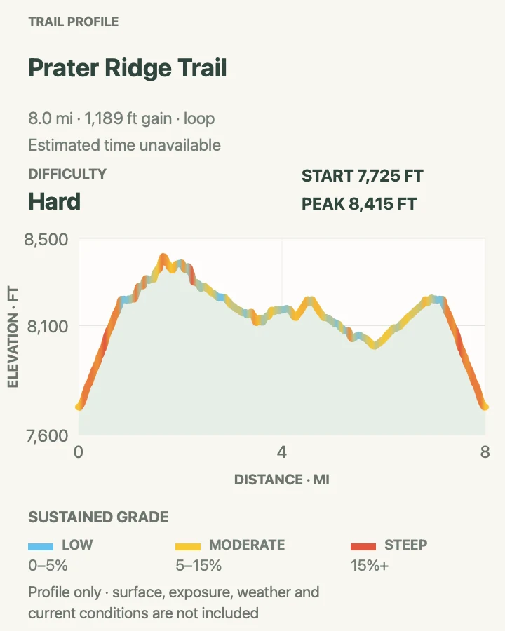
Prater Ridge first climbs 1.1 miles to a junction on the mesa top. The longer north loop follows the edge above Montezuma Valley; the south loop looks into Prater and Morefield canyons. Combining both produces the official 7.8-mile route mapped here.
NPS also publishes shorter choices: 5.7 miles for the north-loop trip or 4.6 miles for the south-loop trip. Decide at the junction using weather, water, and daylight rather than treating the full figure as an obligation.
What helps on this route
- Note the shared stem so the final descent is easy to identify.
- Turn back from exposed ridge terrain before thunder arrives.
Terrain and access: A sustained climb to rolling, exposed mesa-edge loops with rocky tread and limited shelter.

Park Point Trail
- Distance
- 0.3 mile round trip
- Elevation gain
- 60 feet
- Time
- About 20 to 30 minutes
- Difficulty
- Easy
- Route type
- Out and back
- Parking
- Use the Park Point parking area near mile 10; the spur road is not plowed and may close for weather or operations.
- Best time
- A clear calm morning when the Park Point road is open.
- Pets
- Leashed pets may use paved Park Point areas where posted rules allow; keep them out of off-trail terrain.
A short paved climb reaches the 8,572-foot high point of Mesa Verde, two broad viewpoints, and the historic fire lookout. The panorama connects the mesas to the San Juan and La Plata mountains, Sleeping Ute Mountain, and the high desert to the south.
The mileage is tiny but the incline, altitude, wind, and winter access are real constraints. Stay on pavement and signed viewpoint paths: NPS warns that off-trail areas here are subject to rockfall.
What helps on this route
- Bring a layer even when the park entrance is warm.
- Leave the overlook promptly if thunder develops.
Terrain and access: Short, very steep paved path at 8,572 feet with wind and full weather exposure.

Far View Sites Trail
- Distance
- 0.75 mile loop
- Elevation gain
- 85 feet
- Time
- Varies by interpretive stops
- Difficulty
- Easy
- Route type
- Loop
- Parking
- Use the Far View Sites lot when its access road is open; parking is limited to vehicles under 25 feet.
- Best time
- Morning or late afternoon after confirming the access-road status.
- Pets
- Pets are prohibited on the trail and within ancestral sites.
Far View links six interpreted places, including villages and a dry reservoir, along a woodland loop. The route reads as a community landscape rather than a single destination, with signs adding context to settlement and farming between roughly 900 and 1300 CE.
At the August 31, 2026 check, road work had temporarily closed the Far View access road. Keep this route in a future plan only after the live alert clears; never park on the main road or walk through a construction closure.
What helps on this route
- Photograph artifacts only where they rest and never move them.
- Allow time to read the site signs rather than racing the short mileage.
Terrain and access: Gentle mesa-top woodland path among sensitive archeological sites.

Farming Terrace Trail
- Distance
- 0.5 mile round trip
- Elevation gain
- 140 feet
- Time
- About 45 to 60 minutes
- Difficulty
- Easy
- Route type
- Out and back
- Parking
- Use the small signed area on the Cedar Tree Tower road only when that access road is open.
- Best time
- A cool dry morning after checking Cedar Tree Tower road access.
- Pets
- Pets are prohibited on this trail.
Farming Terrace drops into a small side drainage of Soda Canyon, passing check dams and landscape features associated with Ancestral Pueblo farming. The short distance contains about 150 feet of change, so the return climbs more than the mileage suggests.
Construction had temporarily closed the Cedar Tree Tower access road at the August 31, 2026 check. Wait for an official reopening and use the signed parking area; the cultural landscape beyond the tread is not a place to improvise an approach.
What helps on this route
- Look from the trail without stepping onto walls or check dams.
- Carry water even for this short sun-exposed drainage.
Terrain and access: Short descent into a rocky drainage with steps, roughly 150 feet of change, and sensitive cultural features.

Petroglyph Point Trail
- Distance
- 2.4 miles loop
- Elevation gain
- 460 feet
- Time
- About 1.5 to 3 hours
- Difficulty
- Hard
- Route type
- Loop
- Parking
- Use the Mesa Verde Museum area and follow signs from the Spruce Tree House Overlook trail junction.
- Best time
- A dry cool morning, traveling counterclockwise as NPS recommends.
- Pets
- Pets are prohibited on this trail.
Petroglyph Point is the park's most technically demanding designated hike. The counterclockwise circuit traverses Spruce Canyon walls through narrow rock passages, uneven stone steps, loose tread, and exposed edges before reaching the large panel about 1.4 miles in.
Beyond the panel, a roughly one-hundred-foot climb uses rock and sandstone steps to regain the mesa top. This is not an ordinary maintained walk: turn around if scrambling, exposure, wet rock, ice, or opposing traffic exceeds the group's ability, and never touch or mark the panel.
What helps on this route
- Use shoes with secure traction and keep both hands available for the scramble.
- Do not enter Spruce Tree House; it remains closed for rockfall danger.
Terrain and access: Narrow canyon-side tread, loose rock, steep edges, stone stairs, boulder passages, and a hands-on climb.

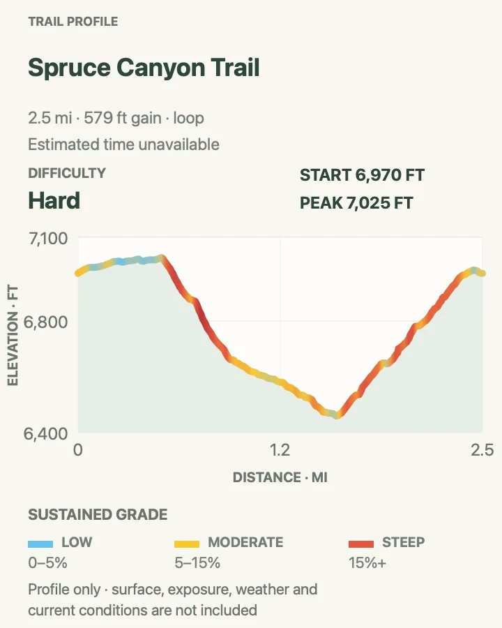
Spruce Canyon Trail
- Distance
- 2.4 miles loop
- Elevation gain
- 580 feet
- Time
- About 1.5 to 2 hours
- Difficulty
- Hard
- Route type
- Loop
- Parking
- Use the Mesa Verde Museum area and follow the signed trail junction near the Spruce Tree House Overlook.
- Best time
- A dry morning when the canyon trail is open and free of ice.
- Pets
- Pets are prohibited on this trail.
Spruce Canyon descends switchbacks from the museum area into a cooler, more sheltered drainage, trading the park's broad viewpoints for close forest and canyon terrain. A steep climb exits the canyon, followed by the developed-area return past the picnic area.
The 558 feet of official elevation change is concentrated and the final third grows rougher. Check winter traction needs, carry enough water for the climb out, and follow the signed return rather than approaching the closed Spruce Tree House.
What helps on this route
- Save energy for the steep exit rather than judging the route by its downhill start.
- Verify trail conditions at the museum before committing to the canyon.
Terrain and access: Steep switchbacks, shaded canyon tread, rocks, roots, and a sustained climb back to the mesa.

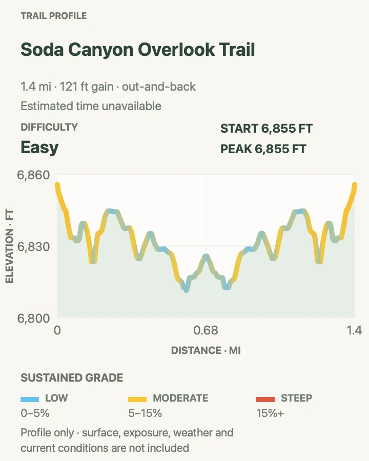
Soda Canyon Overlook Trail
- Distance
- 1.2 miles round trip
- Elevation gain
- 120 feet
- Time
- Varies by overlook stops
- Difficulty
- Easy
- Route type
- Out and back
- Parking
- Use the signed trailhead on Cliff Palace Loop, about 0.5 mile beyond Balcony House, when the loop road is open.
- Best time
- Morning or late afternoon with Cliff Palace Loop open.
- Pets
- Pets are prohibited on this trail.
Soda Canyon follows mostly level pinyon-juniper terrain to three overlooks across the canyon. Balcony House and other alcove sites appear in their wider landscape, making the route useful when a ticketed dwelling tour is not part of the day.
The overlooks are the destination and the boundary. Stay behind barriers and on signed spurs, especially in wind or lightning; crossing an edge for a clearer photograph is both unsafe and harmful to protected ground.
What helps on this route
- Bring binoculars rather than trying to move closer to distant dwellings.
- Confirm Cliff Palace Loop hours before the long drive from the entrance.
Terrain and access: Mostly level woodland tread ending at several exposed canyon-rim overlooks.

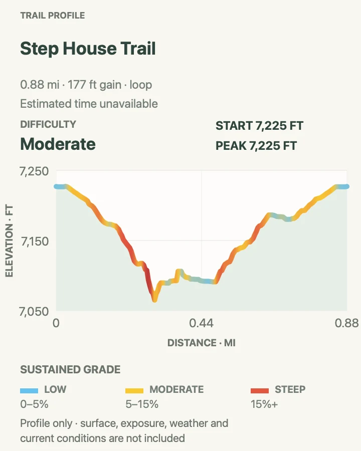
Step House Trail
- Distance
- 1.0 mile loop
- Elevation gain
- 180 feet
- Time
- Allow about 45 minutes
- Difficulty
- Moderate
- Route type
- Loop
- Parking
- Park at the Wetherill Mesa kiosk and pavilion during seasonal operating hours.
- Best time
- Within staffed Step House hours, leaving ample time before the Wetherill gate closes.
- Pets
- Pets are not permitted on the trail to or within Step House.
Step House loops down Long Canyon on paved and gravel surfaces with many steps, reaches an alcove containing evidence from two distinct occupation periods, and climbs back to the pavilion. The 165-foot change and steep grades can be strenuous despite the one-mile length.
Entry is allowed only when the site is staffed. In 2026, NPS lists a 9 a.m. opening and 2:45 p.m. last entry during the Wetherill season. Treat the ranger station and site boundaries as part of the route, and do not enter outside operating hours.
What helps on this route
- Check Step House hours separately from the Wetherill gate schedule.
- Use the designated exit path if staff directs one-way movement through the site.
Terrain and access: Steep paved-and-gravel loop with stairs, about 165 feet of change, and an archeological-site visit.

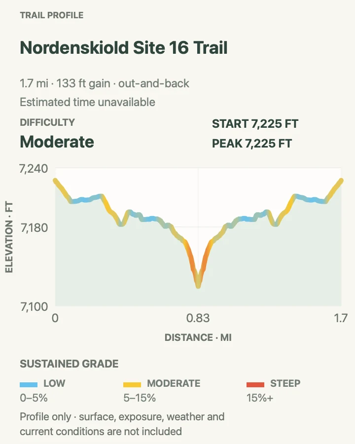
Nordenskiöld Site #16 Trail
- Distance
- 2.0 miles round trip
- Elevation gain
- 130 feet
- Time
- Varies by pace and overlook stop
- Difficulty
- Moderate
- Route type
- Out and back
- Parking
- Begin at the Wetherill Mesa kiosk and follow the gravel route south to the signed site-trail junction.
- Best time
- A cool morning within the Wetherill Mesa operating season.
- Pets
- Leashed pets are permitted; keep the leash six feet or shorter and stay on the trail.
The trail crosses open Wetherill Mesa and branches to an overlook of a roughly fifty-room cliff dwelling in Rock Canyon. Its name recalls Gustaf Nordenskiöld's 1891 excavation, a history best considered alongside the continuing cultural connections of affiliated tribes.
The outbound leg descends gently enough to disguise the uphill return, and the burned mesa offers almost no shade or water. Carry water from the pavilion area and leave the rim early when storms build.
What helps on this route
- Record the junction with the shared Wetherill route for the return.
- Protect paws from hot gravel if hiking with a permitted leashed pet.
Terrain and access: Open gravel path with little shade, a gentle outbound descent, uphill return, and exposed canyon overlook.

Badger House Community Trail
- Distance
- 2.25 miles round trip
- Elevation gain
- 160 feet
- Time
- Varies by interpretive stops
- Difficulty
- Moderate
- Route type
- Loop
- Parking
- Start at the Wetherill Mesa kiosk and use the signed gravel route toward Badger House Community.
- Best time
- Morning during the Wetherill season, before heat or thunderstorms.
- Pets
- Leashed pets are permitted; keep them on the route and outside ancestral structures.
Badger House combines the approach from the kiosk with a one-mile interpretive loop through four excavated mesa-top villages. Together the sites represent roughly six hundred years of Pueblo history and show change across a lived landscape rather than a single construction moment.
Most of the route is relatively level, but reaching the fourth site involves a steep hill. Partially paved and gravel surfaces may require assistance for some visitors, and every wall and artifact must be viewed from the established path.
What helps on this route
- Allow more time than the mileage suggests for four site stops.
- Carry pet water and test pavement temperature if bringing a permitted leashed animal.
Terrain and access: Partially paved and gravel mesa-top route, mostly level with one steeper hill and sensitive sites.

Long House Loop
- Distance
- 5.0 miles loop
- Elevation gain
- 340 feet
- Time
- Varies by overlooks and side stops
- Difficulty
- Moderate
- Route type
- Loop
- Parking
- Begin at the Wetherill Mesa kiosk and pavilion within the seasonal gate schedule.
- Best time
- An early, cool Wetherill morning with a firm return time before the gate closes.
- Pets
- Leashed pets are permitted on the loop but not on the separate trail into Long House.
Long House Loop follows the paved mesa-top circuit to Badger House Community, Long House Overlook, and Kodak House Overlook. The five-mile mapped loop is distinct from the ranger-guided Long House tour, which leaves from its own trailhead and requires a reservation.
Fire changed this landscape in 2000, leaving long exposed sections with little shade and few places to shelter from lightning. Track time carefully: side trips add distance, and every visitor must be back through the controlled Wetherill gate by the posted closure.
What helps on this route
- Do not confuse Long House Overlook with admission to the dwelling tour.
- Set a turnaround that includes side-stop time and the walk back to the pavilion.
Terrain and access: Paved, rolling mesa-top loop with long sun-exposed sections, overlooks, and optional signed side trips.

Official planning sources
Trail access and safety details were checked against these National Park Service pages. The maps and profiles follow the corresponding route geometry.
Map data © OpenStreetMap contributors. Trail geometry and planning details include National Park Service public information.