15 Best Hikes in Petrified Forest National Park
Fifteen distinct Petrified Forest hikes, including every developed trail and the park's official cross-country routes, with custom maps, measured profiles, and current planning notes.
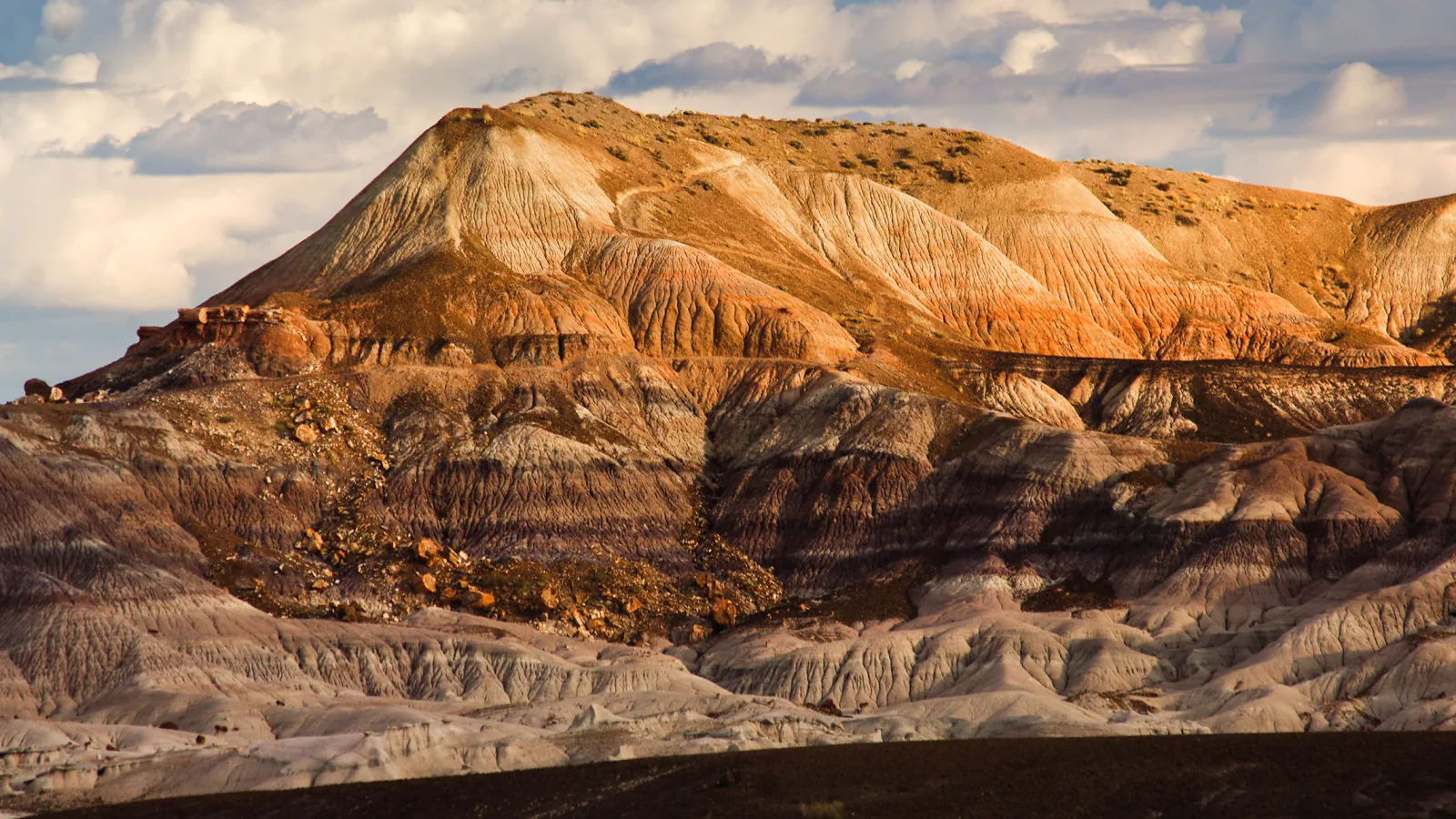
Petrified Forest has two very different kinds of hiking. Short developed trails begin at signed parking areas and concentrate on fossil wood, badlands, petroglyphs, and ancestral places. The park's Off the Beaten Path routes leave constructed tread behind. Those trips depend on a visitor-center handout, careful navigation, and judgment about fragile ground, washes, bluff edges, and weather.
This guide keeps those categories visible. It covers all developed trail itineraries without splitting the shared Long Logs and Agate House corridor into repetitive entries, then adds the eight cross-country routes currently named by the National Park Service. Published distance appears in each trail fact block; the profile reports gain measured from the preserved geometry behind the map.
Planning details were checked on August 31, 2026. That date falls within Arizona's June 15 through September 30 monsoon season, when afternoon lightning and flash flooding can abruptly end a hike. Park hours, roads, weather, and closures change. Read the live condition panels, obtain the current route handout for every cross-country outing, and follow posted signs and ranger direction over any line shown here.
Live park weather
Petrified Forest National Park
Painted Desert Visitor Center
Loading the latest conditions and alerts…
What changes a hiking day here
Know which routes have tread
Tawa, Painted Desert Rim, Puerco Pueblo, Blue Mesa, Crystal Forest, Giant Logs, Long Logs, and Agate House use developed paths. Billings Gap, Historic Blue Forest, Dead Wash, First Forest Point, Old Jasper Forest Road, Onyx Bridge, Red Basin, and Wilderness Loop involve abandoned road, faint route, or open cross-country travel. A custom map does not turn an off-trail itinerary into a maintained trail.
Pick up the current Off the Beaten Path handout
NPS tells visitors to ask for these routes at a visitor center and warns that route-finding skills are required and distances are approximate. Confirm the legal parking location, current landmarks, and any closure before setting out. Save the mobile map for backup, but navigate from several forms of evidence rather than one phone screen.
Protect fossil and cultural sites
Petrified wood, fossils, pottery fragments, stone flakes, petroglyphs, and historic objects must stay where they are. Do not sit or climb on walls or fossil logs, dig around partly exposed material, or walk on soft badland slopes merely to shorten a line. On Agate House, remain at least fifteen feet from the closed structure.
Carry the day's water from a developed area
NPS lists drinking water at the Painted Desert Community Complex and Rainbow Forest Museum, not at stops along the park road or in the backcountry. Summer guidance is one gallon per person per day while hiking. Start with the full supply rather than planning to refill midway.
Treat monsoon clouds as a turnaround signal
The open grasslands and mesas offer little lightning shelter, and metal-roof shade structures are not storm shelters. Intense rain can flood washes and roads. Return to the vehicle before a storm reaches the route, never cross moving water, and postpone clay-rich badland hikes when wet footing would damage the surface.
Use the pet rule with heat judgment
Leashed pets are permitted on developed trails and in designated wilderness; the leash must be six feet or shorter. Pets are not allowed inside park buildings. Carry animal water, keep pets away from wildlife and sensitive resources, collect waste, and never leave an animal in a hot vehicle.
Fit the hike inside the park gate day
Petrified Forest is generally a day-use park with seasonal operating hours. A long Red Basin or Wilderness plan must include the drive to the exit before the gate closes. Verify the day's hours and road conditions instead of relying on a previous visit or a search-result snippet.
| Trail | Distance | Time | Difficulty | Best for |
|---|---|---|---|---|
| Long Logs and Agate House Loop Trail | 2.6 miles round trip | Varies by pace and site stops | Easy | The largest south-end fossil-wood outing and an ancestral site |
| Giant Logs Trail | 0.4 mile loop | Varies by interpretive stops | Easy | Large fossil logs in a compact developed walk |
| Crystal Forest Trail | 0.75 mile loop | Varies by pace and fossil stops | Easy | Close views of crystal-lined petrified wood |
| First Forest Point | 4.2 miles round trip | Varies with route finding and conditions | Moderate | A mesa viewpoint above the historic First Forest area |
| Old Jasper Forest Road | 2.5 miles round trip | Varies by pace and fossil stops | Easy | A gentler backcountry introduction on a historic road bed |
| Red Basin Clam Beds Hike | Approximately 8.5 miles round trip | Allow most of a day; pace depends on navigation and conditions | Hard | A long fossil-country route through the park's expansion lands |
| Historic Blue Forest Trail | 3.0 miles round trip | Varies by route finding and conditions | Moderate | Historic CCC route and close blue-and-white badland terrain |
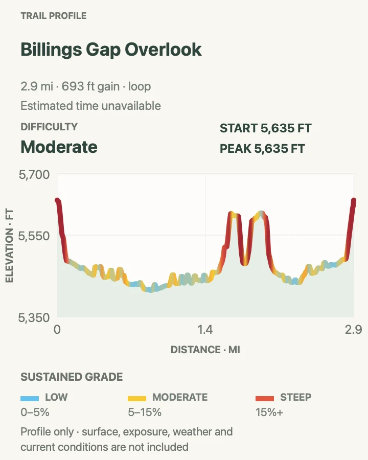
| Billings Gap Overlook | 3.0 miles round trip | NPS estimates 1 to 3 hours | Moderate | A high badland edge with views into two broad valleys |
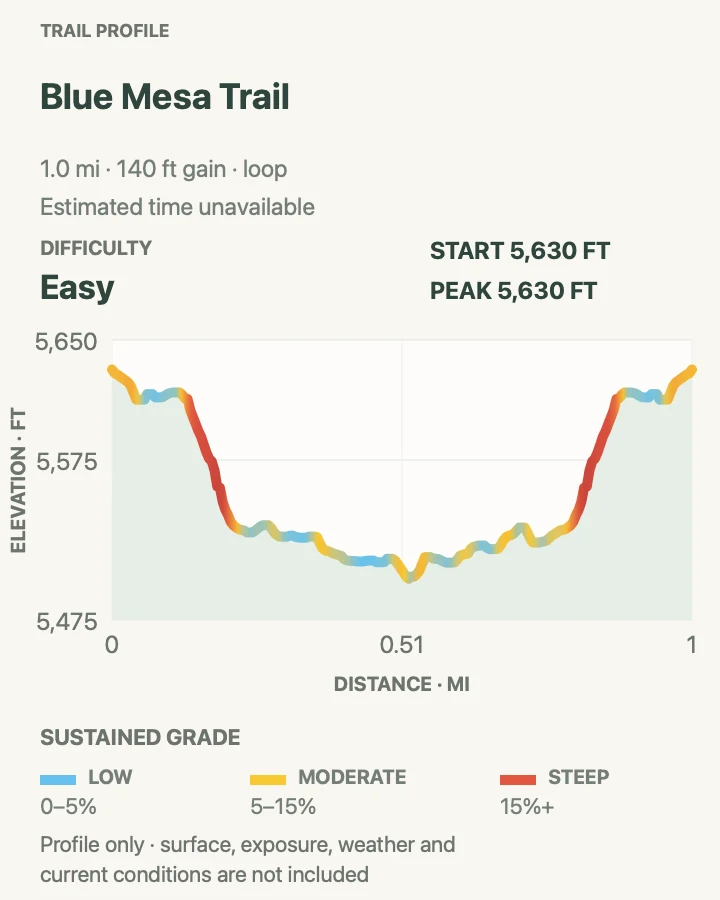
| Blue Mesa Trail | 1.0 mile loop | Varies by pace and photo stops | Easy | A developed descent among blue bentonite hills |
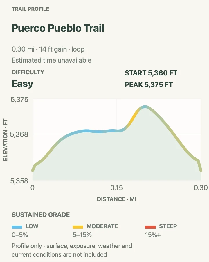
| Puerco Pueblo Trail | 0.3 mile loop | Varies by interpretive stops | Easy | Ancestral Pueblo architecture and petroglyph viewpoints |
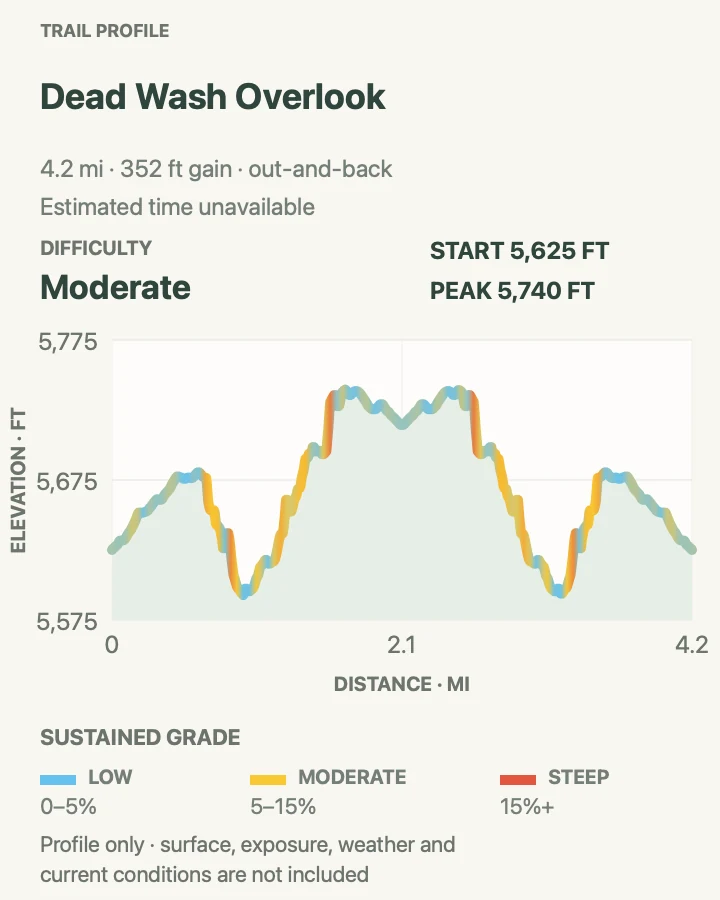
| Dead Wash Overlook | 4.0 miles round trip | Varies with route finding and scrambling | Moderate | Grassland, Black Forest fossil wood, and a broad drainage overlook |
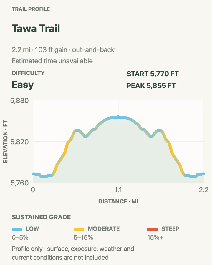
| Tawa Trail | 2.4 miles round trip | Varies by pace | Easy | Open grassland between a rim viewpoint and visitor services |
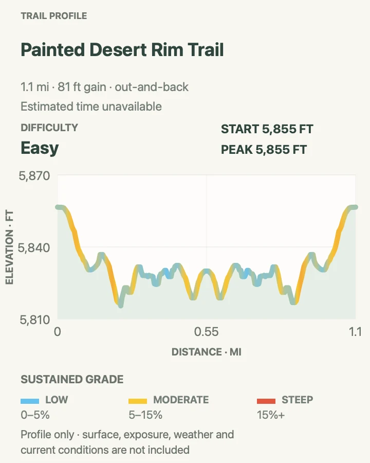
| Painted Desert Rim Trail | 1.0 mile round trip | Varies by viewpoint stops | Easy | A short unpaved rim walk through pinyon-juniper woodland |
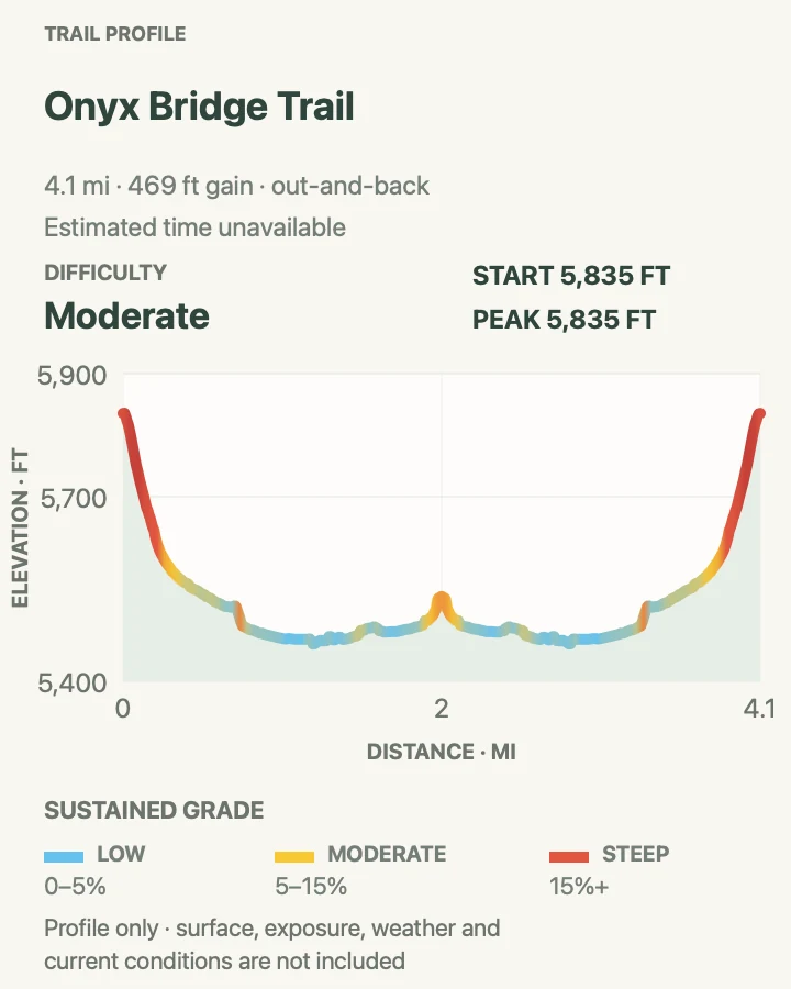
| Onyx Bridge Trail | 4.0 miles round trip | Varies with route finding and conditions | Moderate | A shorter wilderness trip to a named fossil-log destination |
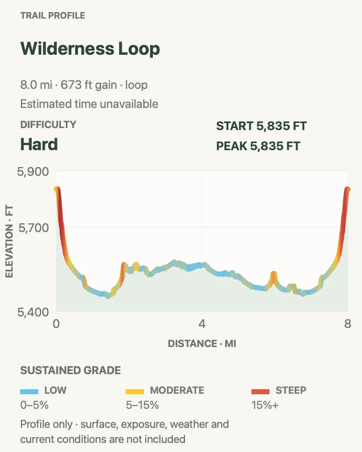
| Wilderness Loop | Approximately 7.0 miles round trip | Allow several hours; pace depends on navigation and conditions | Hard | A sustained circuit through several wilderness fossil-wood areas |
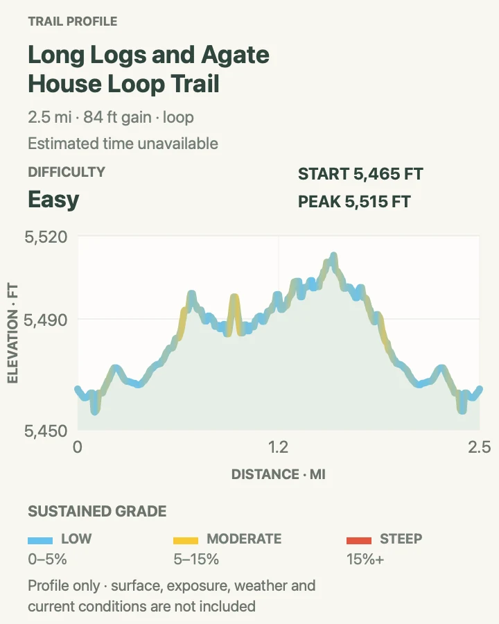
Long Logs and Agate House Loop Trail
- Distance
- 2.6 miles round trip
- Elevation gain
- 85 feet
- Time
- Varies by pace and site stops
- Difficulty
- Easy
- Route type
- Loop with out-and-back spur
- Parking
- Begin at Rainbow Forest Museum and follow the signed shared access trail.
- Best time
- A cool morning with enough time to visit both areas without rushing.
- Pets
- Leashed pets are permitted; use a leash six feet or shorter and keep animals away from the closed structure.
This combined itinerary uses the official shared approach from Rainbow Forest Museum, visits Agate House on an out-and-back branch, and circles the Long Logs deposit before returning. Keeping it as one outing avoids repeating the same first half-mile in separate guide entries.
Long Logs spreads fossil trunks across gray badland ground. Agate House is an eight-room ancestral Pueblo structure built with petrified wood. The building is closed for physical-safety reasons, so stay at least fifteen feet away and never touch, climb, or sit on its walls.
What helps on this route
- Photograph fossil wood where it lies and leave every fragment in place.
- Remember that bicycles are allowed only on the first half-mile access segment, not on the trail loops.
Terrain and access: A paved shared approach gives way to rougher, narrower trail with exposed desert footing and short steeper grades.

Giant Logs Trail
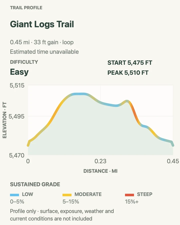
- Distance
- 0.4 mile loop
- Elevation gain
- 35 feet
- Time
- Varies by interpretive stops
- Difficulty
- Easy
- Route type
- Loop
- Parking
- Start behind Rainbow Forest Museum at the signed trail entrance.
- Best time
- Early or late in the day when the exposed stairs are cooler.
- Pets
- Leashed pets are permitted; keep the leash six feet or shorter.
Giant Logs climbs behind Rainbow Forest Museum through one of the park's densest displays of large, colorful petrified trunks. Old Faithful, near the upper part of the loop, is almost ten feet wide at its base and gives the short route a clear destination.
The distance can disguise the effort. Several stair sets and grades near twenty percent make the loop less accessible than its paved surface suggests. Use the museum area to ask about an appropriate alternative if stairs are a barrier.
What helps on this route
- Use the trail guide available at Rainbow Forest Museum for context.
- Keep children and pets on the path around steep slopes and fragile fossil deposits.
Terrain and access: Paved but steep in places, with multiple stair sets, open sun, and short climbs among fossil logs.

Crystal Forest Trail
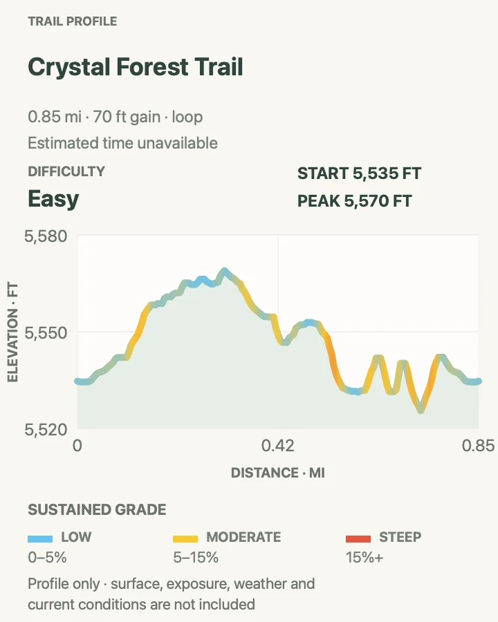
- Distance
- 0.75 mile loop
- Elevation gain
- 70 feet
- Time
- Varies by pace and fossil stops
- Difficulty
- Easy
- Route type
- Loop
- Parking
- Use the signed Crystal Forest parking area on the park road.
- Best time
- Morning or late afternoon for cooler pavement and angled light on the logs.
- Pets
- Leashed pets are permitted; keep the leash six feet or shorter.
Crystal Forest circles through a broad deposit where quartz crystals fill cavities in many exposed logs. The loop is developed and easy to follow, yet its measured grades and cross-slopes exceed flat-access standards in several places.
The fossil material is protected even when a fragment looks loose or common. Leave it exactly where it rests and report removal rather than confronting another visitor. The open setting also means there is little relief from wind, sun, or an approaching storm.
What helps on this route
- Slow down at rough transitions and water bars if using wheeled mobility equipment.
- Carry eye protection on high-wind days when sand can cross the trail.
Terrain and access: Paved developed loop with rolling grades, notable cross-slope, sparse shade, and exposed fossil deposits.

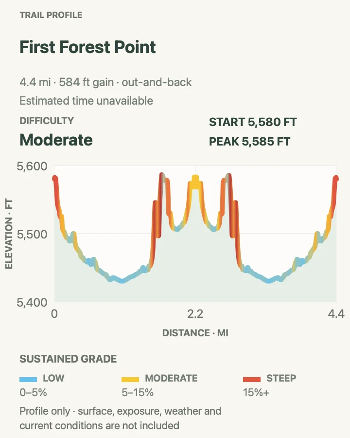
First Forest Point
- Distance
- 4.2 miles round trip
- Elevation gain
- 580 feet
- Time
- Varies with route finding and conditions
- Difficulty
- Moderate
- Route type
- Out and back
- Parking
- Begin from the legal Jasper Forest Overlook parking area after obtaining the current NPS route handout.
- Best time
- A dry, cool morning with clear visibility and stable weather.
- Pets
- Leashed pets are permitted, but sharp stone, heat, and the lack of water make conservative judgment necessary.
First Forest Point leaves the Jasper Forest overlook for open country containing sandstone boulders, exposed petrified wood, and a prominent mesa. The name recalls early visitors who reached this first major fossil-wood area by wagon from the Adamana rail stop.
There is no maintained tread to hold attention on the return. Bind the map to visible landforms as you go, protect any petroglyphs or artifacts encountered, and turn around before clouds, poor visibility, or uncertain navigation erases the margin for getting back.
What helps on this route
- Photograph the handout and record the parking area before leaving the road.
- Do not climb soft badland slopes to force a straight line toward the point.
Terrain and access: Cross-country grassland, washes, sandstone boulders, badland margins, and a mesa ascent with no maintained trail.

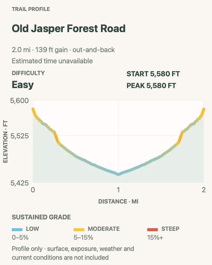
Old Jasper Forest Road
- Distance
- 2.5 miles round trip
- Elevation gain
- 140 feet
- Time
- Varies by pace and fossil stops
- Difficulty
- Easy
- Route type
- Out and back
- Parking
- Start at Jasper Forest Overlook and confirm the route with the current visitor-center handout.
- Best time
- A cool, dry morning when the old road trace is easy to read.
- Pets
- Leashed pets are permitted; carry animal water and keep paws off sharp fossil fragments.
The Jasper Forest outing follows remnants of a 1930s vehicle road into a wide concentration of petrified wood. Its old grade creates a more legible line than the park's fully cross-country routes, making this a useful first Off the Beaten Path choice for hikers who already have basic navigation skills.
Erosion has interrupted the retired road and erased its former destination, Eagle's Nest Rock. Follow the current handout rather than trying to reconstruct automobile access, and avoid walking directly through fossil concentrations when durable ground is available.
What helps on this route
- Look back regularly so the return view toward the overlook stays familiar.
- Treat wash cuts and eroded road edges as route-finding decisions, not invitations to build a new shortcut.
Terrain and access: Faint abandoned road, open desert, eroded wash crossings, and gently rolling ground among fossil deposits.

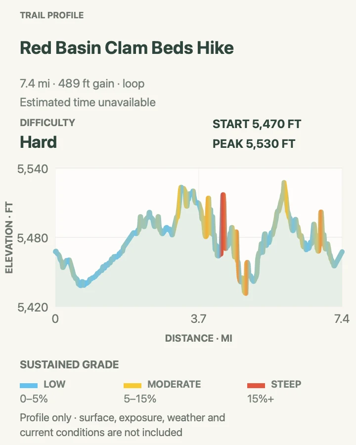
Red Basin Clam Beds Hike
- Distance
- Approximately 8.5 miles round trip
- Elevation gain
- 490 feet
- Time
- Allow most of a day; pace depends on navigation and conditions
- Difficulty
- Hard
- Route type
- Loop
- Parking
- Obtain the current NPS handout and legal parking directions from a visitor center before committing to this remote route.
- Best time
- A cool, dry day with stable weather and ample gate-hour margin.
- Pets
- Leashed pets are permitted, but distance, heat, rough stone, and no water make this an advanced pet outing.
Red Basin reaches the park's 2004 boundary-expansion country, where hoodoos, multicolored badlands, petrified wood, petroglyphs, and fossil clam beds appear across a broad off-trail circuit. It is the longest itinerary in this guide and the one least suited to a casual roadside decision.
The NPS distance is approximate, and the preserved route geometry measures shorter than that planning figure. Use 8.5 miles for water, time, and gate planning. The map is navigation evidence, not a promise of continuous tread or a license to cross unstable mud, flooded washes, or sensitive fossil ground.
What helps on this route
- Carry redundant navigation, extra water, and a firm turnaround time tied to park closing.
- Leave fossils and cultural material in place; record a location for staff instead of handling a find.
Terrain and access: Long cross-country travel across grassland, washes, badlands, hoodoo country, and exposed fossil-bearing ground.

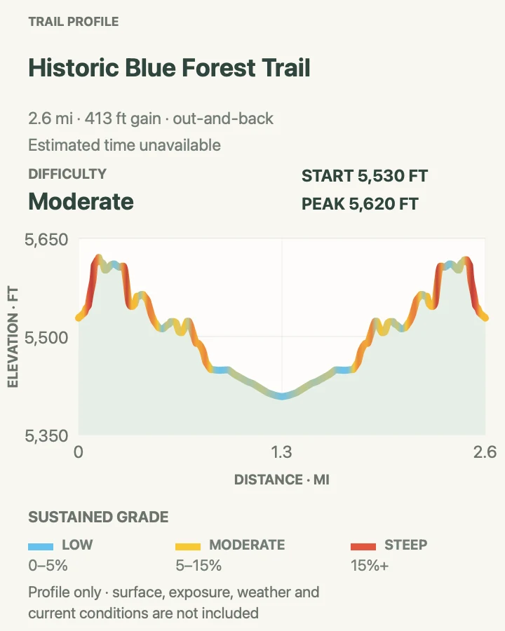
Historic Blue Forest Trail
- Distance
- 3.0 miles round trip
- Elevation gain
- 410 feet
- Time
- Varies by route finding and conditions
- Difficulty
- Moderate
- Route type
- Out and back
- Parking
- Use the legal Blue Mesa Loop Road access described in the current NPS route handout.
- Best time
- Dry morning light before badland clay heats or storms build.
- Pets
- Leashed pets are permitted; protect paws from heat and avoid wet clay.
Civilian Conservation Corps crews built the Blue Forest Trail between 1934 and 1937 to connect the lower and upper Blue Mesa roads. The park restored the hiking route in 2013, giving experienced visitors a longer look at badland layers and petrified wood beyond the developed Blue Mesa loop.
Erosion is the point of the scenery and the reason to stay disciplined. Follow durable route evidence, do not kick steps into clay, and postpone the trip when wet bentonite would make footing slick and leave lasting scars.
What helps on this route
- Carry the current route sheet even if the opening section appears obvious.
- Keep the easier one-mile Blue Mesa loop as the fallback when weather or footing is marginal.
Terrain and access: Historic route across steep, exposed blue-and-white badland hills with loose and potentially slick clay.

Billings Gap Overlook
- Distance
- 3.0 miles round trip
- Elevation gain
- 690 feet
- Time
- NPS estimates 1 to 3 hours
- Difficulty
- Moderate
- Route type
- Loop
- Parking
- Follow the current NPS App tour or visitor-center handout to the legal start and parking location.
- Best time
- Morning or late-day light in dry, stable weather.
- Pets
- Leashed pets are permitted; keep animals away from unstable edges.
Billings Gap traces the steep edge of Blue Mesa toward a viewpoint between the mesa and the landform east of it. The elevated line looks across eroded badlands on one side and broad grass valleys on the others, with little shelter from wind or weather.
This is a route rather than constructed trail. Use the NPS tour stops and handout to verify the line, avoid crumbling edges, and give soft formations a wide berth. The mapped loop should never override a closure or a safer out-and-back decision.
What helps on this route
- Download the NPS App tour before losing service.
- Stay well back from undercut slopes and leave the edge before lightning develops.
Terrain and access: Cross-country mesa edge, grassland, eroded badland margins, loose slopes, and sustained exposure.

Blue Mesa Trail
- Distance
- 1.0 mile loop
- Elevation gain
- 140 feet
- Time
- Varies by pace and photo stops
- Difficulty
- Easy
- Route type
- Loop
- Parking
- Use the Blue Mesa sun-shelter parking area on Blue Mesa Loop Road.
- Best time
- Early morning for cooler temperatures and quieter switchbacks.
- Pets
- Leashed pets are permitted; hot pavement and exposed clay require care.
Blue Mesa descends from the rim into blue, gray, and purple bentonite formations where erosion exposes fossil wood and other Triassic material. The lower loop is straightforward, but every return must climb the same steep paved approach back to the parking shelter.
Dry clay can be firm and wet clay can become extremely slick. Stay on the paved-and-gravel route, avoid social paths on the formations, and move back to the vehicle before rain or lightning reaches the mesa.
What helps on this route
- Save energy for the steep final climb to the rim.
- Use the overlook when weather makes the loop a poor choice rather than stepping onto wet clay.
Terrain and access: Steep paved descent and climb connected by gravel tread among exposed clay badlands; little shade.

Puerco Pueblo Trail
- Distance
- 0.3 mile loop
- Elevation gain
- 15 feet
- Time
- Varies by interpretive stops
- Difficulty
- Easy
- Route type
- Loop
- Parking
- Use the signed Puerco Pueblo parking area.
- Best time
- Morning or late afternoon when the open mesa-top walk is cooler.
- Pets
- Leashed pets are permitted; keep them off walls and away from cultural material.
This short paved circuit visits the remains of a large ancestral Pueblo community occupied more than six centuries ago. Petroglyphs can be viewed from the south side of the loop, where the designated overlook protects both visitors and the rock surfaces.
The site's importance is not measured by mileage. Stay off walls and boulders, never touch or trace petroglyphs, and leave every pottery fragment or stone object where it lies. A short spur may be less accessible than the main paved loop.
What helps on this route
- Bring binoculars or a zoom lens for petroglyph details.
- Make room at overlooks rather than stepping beyond barriers.
Terrain and access: Mostly level paved loop in open sun, with one less-accessible short spur and sensitive cultural resources.

Dead Wash Overlook
- Distance
- 4.0 miles round trip
- Elevation gain
- 350 feet
- Time
- Varies with route finding and scrambling
- Difficulty
- Moderate
- Route type
- Out and back
- Parking
- Use the legal start identified on the current NPS visitor-center handout; never stop in the road.
- Best time
- A dry, cool morning with good visibility.
- Pets
- Leashed pets are permitted, but boulders, sharp rock, and exposure may make the route unsuitable for some animals.
Dead Wash crosses open grassland east of the park road, drops through a bluff, passes petrified wood associated with Black Forest, and finishes at an overlook across the Dead Wash drainage. Boulder moves and wash crossings make it more physical than its moderate overall elevation change suggests.
The route is faint and its endpoint is an exposed viewpoint rather than a signed platform. Keep the return bearing in mind, avoid unstable edges, and retreat if a wash begins carrying water or if scrambling conditions become slick.
What helps on this route
- Use the handout's intermediate landmarks instead of aiming only at the distant endpoint.
- Keep hands free for boulder steps and carry water inside the pack.
Terrain and access: Trail-less grassland, bluff descent, boulder scrambling, wash crossings, and an exposed overlook.

Tawa Trail
- Distance
- 2.4 miles round trip
- Elevation gain
- 100 feet
- Time
- Varies by pace
- Difficulty
- Easy
- Route type
- Out and back
- Parking
- Begin at Tawa Point or the Painted Desert Visitor Center; this map returns to the starting trailhead.
- Best time
- A cool, calm morning or an evening finished before the park gate deadline.
- Pets
- Leashed pets are permitted; carry water and use a leash six feet or shorter.
Tawa links the Painted Desert Visitor Center with Tawa Point across high grassland. The one-way NPS figure is 1.2 miles; this guide maps the complete out-and-back so the comparison table reflects the distance needed to return to a parked vehicle.
The groomed surface meets outdoor-developed accessibility standards, though it remains exposed to sun, wind, and storms. The trail's open character also makes it a poor place to wait out lightning. Turn around early enough to reach a building or vehicle before weather arrives.
What helps on this route
- Confirm which endpoint will hold the vehicle before starting.
- Use visitor-center water and restrooms before the out-and-back.
Terrain and access: Groomed, broad grassland tread with gentle grades, minimal obstacles, and full weather exposure.

Painted Desert Rim Trail
- Distance
- 1.0 mile round trip
- Elevation gain
- 80 feet
- Time
- Varies by viewpoint stops
- Difficulty
- Easy
- Route type
- Out and back
- Parking
- Use Tawa Point or Kachina Point and return to the same lot unless a shuttle is arranged.
- Best time
- Morning or late afternoon in dry weather.
- Pets
- Leashed pets are permitted; keep them away from rim edges.
Painted Desert Rim joins Tawa and Kachina points along an unpaved woodland path above the Painted Desert. It is a more textured alternative to the nearby paved overlooks, with changing views through pinyon and juniper rather than one fixed platform.
Water bars, gravel, steep local grades, and cross-slope can limit strollers and mobility devices even though the trail has no stairs. Stay on the established line near rim edges and let oncoming hikers pass where the tread widens.
What helps on this route
- Plan the return to the same parking point before walking the connector.
- Keep clear of cliff edges in wind and leave the rim when thunder develops.
Terrain and access: Unpaved dirt-and-gravel rim tread with water bars, short steep grades, cross-slope, and scattered woodland shade.

Onyx Bridge Trail
- Distance
- 4.0 miles round trip
- Elevation gain
- 470 feet
- Time
- Varies with route finding and conditions
- Difficulty
- Moderate
- Route type
- Out and back
- Parking
- Obtain the current route handout and confirm the legal Painted Desert wilderness start before leaving the developed area.
- Best time
- A cool, dry morning with clear return visibility.
- Pets
- Leashed pets are permitted; carry animal water and keep pets off the fossil log.
Onyx Bridge reaches a long petrified trunk eroding from the Black Forest bed in the Painted Desert wilderness. It shares part of the country used by the longer Wilderness Loop, but the named log provides a distinct, shorter turnaround for hikers who do not need the full circuit.
There is no maintained trail or destination platform. Use the route handout, keep a conservative distance from the fossil, and navigate around fragile ground rather than walking directly over deposits. The return can look different once the low point disappears behind folds in the terrain.
What helps on this route
- Mark the legal starting point and check the return view before descending.
- Do not stand or sit on Onyx Bridge for a photograph.
Terrain and access: Open wilderness, slopes, washes, and indistinct cross-country travel to an exposed fossil bed.

Wilderness Loop
- Distance
- Approximately 7.0 miles round trip
- Elevation gain
- 670 feet
- Time
- Allow several hours; pace depends on navigation and conditions
- Difficulty
- Hard
- Route type
- Loop
- Parking
- Get the current NPS handout and confirm the legal Painted Desert wilderness parking location before starting.
- Best time
- A cool, dry day with stable weather and a large gate-hour margin.
- Pets
- Leashed pets are permitted, but the distance, sharp footing, exposure, and lack of water demand conservative pet judgment.
Wilderness Loop makes a broad circuit through Black Forest fossil beds in the Painted Desert wilderness. It reaches several areas where petrified logs continue to emerge from the Chinle Formation, spreading the experience across open country instead of focusing on one named destination.
The NPS distance is approximate and the landscape supplies few constructed cues. Keep the full route, return bearing, water, weather, and park closing time in one decision. If navigation confidence drops, retrace a known line rather than pressing farther around the loop to make the map close.
What helps on this route
- Carry redundant navigation and compare the map with landforms at frequent intervals.
- Choose Onyx Bridge or a developed trail when heat, wind, clouds, or daylight reduce the margin for a seven-mile route.
Terrain and access: Long cross-country wilderness circuit over open grassland, washes, slopes, fossil beds, and badland margins without maintained tread.

Official planning sources
Trail access and safety details were checked against these National Park Service pages. The maps and profiles follow the corresponding route geometry.
Map data © OpenStreetMap contributors. Trail geometry and planning details include National Park Service public information.