25 Best Hikes in Olympic National Park
Twenty-five Olympic National Park hikes across Hurricane Ridge, Lake Crescent, Sol Duc, the rain forests, wilderness coast, and serious backcountry, with reviewed maps and elevation profiles.
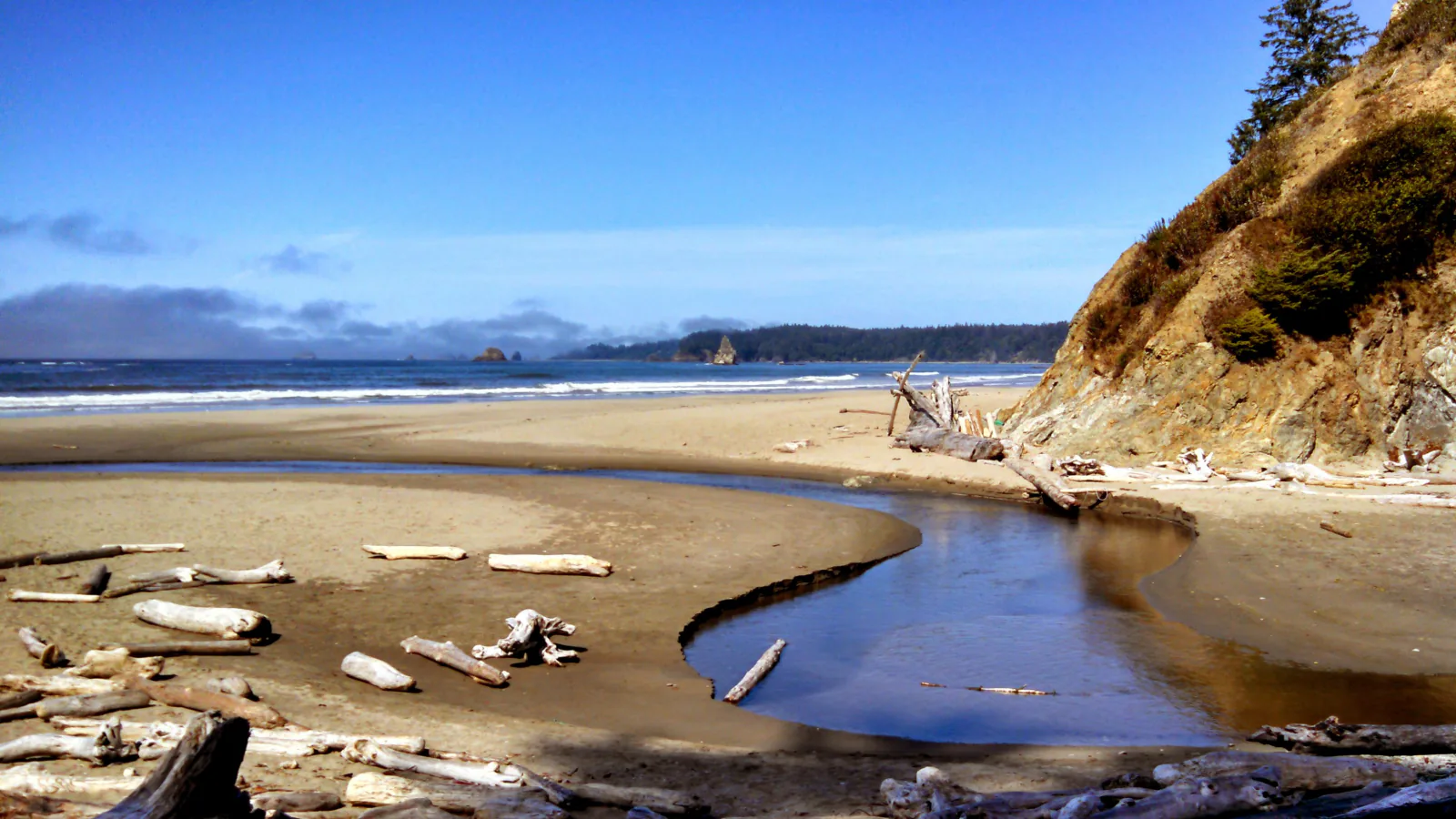
Olympic is not one trail district with a few side trips. Hurricane Ridge can be sunny while the Hoh is dripping, and a calm inland forecast says little about the tide squeezing a beach route. Driving between those places consumes real time. A sensible hiking list has to account for geography before it ranks scenery.
These 25 routes range from a half-mile rain-forest loop to backcountry trips that belong on a backpacking itinerary. Each map uses reviewed route geometry, and each elevation card comes from that exact line. Where the National Park Service and the reviewed track measure different geometries, both figures are stated rather than blended into false precision.
Conditions were checked on August 29, 2026. Hurricane Ridge, Lake Crescent, Sol Duc, the Hoh, Ozette, and Graves Creek are open. Hurricane Hill Road has a planned closure from 7 to 11 a.m. on September 1. The South Shore Quinault Road washout means Graves Creek must be reached from North Shore Road. The Hoh is open, but summer entrance waits can reach two hours between late morning and mid-afternoon. Those facts can change faster than this page.
What changes a hiking day here
Build a regional day, not a park-wide checklist
Hurricane Ridge and Lake Crescent pair reasonably. The Hoh and Ruby Beach can share a long day if parking and tide cooperate. Ozette and Shi Shi are separate northwest-coast commitments, and Graves Creek is reached by a slow road from the Quinault side. Trying to collect three corners of the park usually produces more windshield than trail.
Mountain roads decide some trail days
Hurricane Ridge Road can close for weather or repair work. Obstruction Point Road is narrow gravel with steep drop-offs and is unsuitable for RVs and trailers. Royal Basin begins at a Forest Service trailhead outside the main road loop and requires a parking pass. Check the exact approach before committing to an alpine start.
The Hoh parking queue is part of the route
NPS recommends reaching the Hoh before 8 a.m. or after 5 p.m. in summer. Once the lot fills, vehicles are metered at the entrance and waits can reach two hours. There is no pass-holder bypass lane. Carry food and fuel before turning onto Upper Hoh Road; neither is sold at the visitor center.
A tide table is safety equipment
Beach mileage changes with headlands, high surf, and stream crossings. Carry an official tide table and a topographic map marked with tidal restrictions for Ozette and Shi Shi. Drift logs can roll without warning. A rope on a coastal overland is not an NPS installation or inspection. Turn around before a rising tide removes the safe return.
Overnights require more than a campsite idea
Every wilderness overnight requires an advance permit. Quota areas can fill, and approved bear canisters are required on the wilderness coast and in several interior zones. Blue Glacier, Royal Basin, High Divide, and Enchanted Valley are backpacking routes for most parties.
Pet rules change at one selected beach
Pets are prohibited on park trails and on the wilderness coast. Ruby Beach is the exception in this list: leashed pets are allowed there. Keep the leash no longer than six feet, control waste, and remember that driftwood, surf, and wildlife make a beach different from a paved dog walk.
| Trail | Distance | Time | Difficulty | Best for |
|---|---|---|---|---|
| Hurricane Hill via Hurricane Ridge | About 3.2 miles by NPS; 3.5 miles on the reviewed track | 1 hr 50 min | Moderate | A paved mountain climb with wide views and a defined turnaround |
| Sunrise View Point via High Ridge Nature Trail | 0.9-mile loop on the reviewed track | 29 min | Moderate | A short ridge loop when Hurricane Hill is too much or time is tight |
| Mount Angeles via Hurricane Ridge Trail | About 5.8 miles out and back | 4 hr 11 min | Moderate | A longer high-country route with a summit objective |
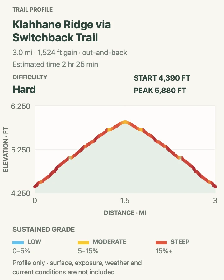
| Klahhane Ridge via Switchback Trail | About 3.1 miles out and back | 2 hr 25 min | Hard | A short, hard climb that reaches open ridge country quickly |
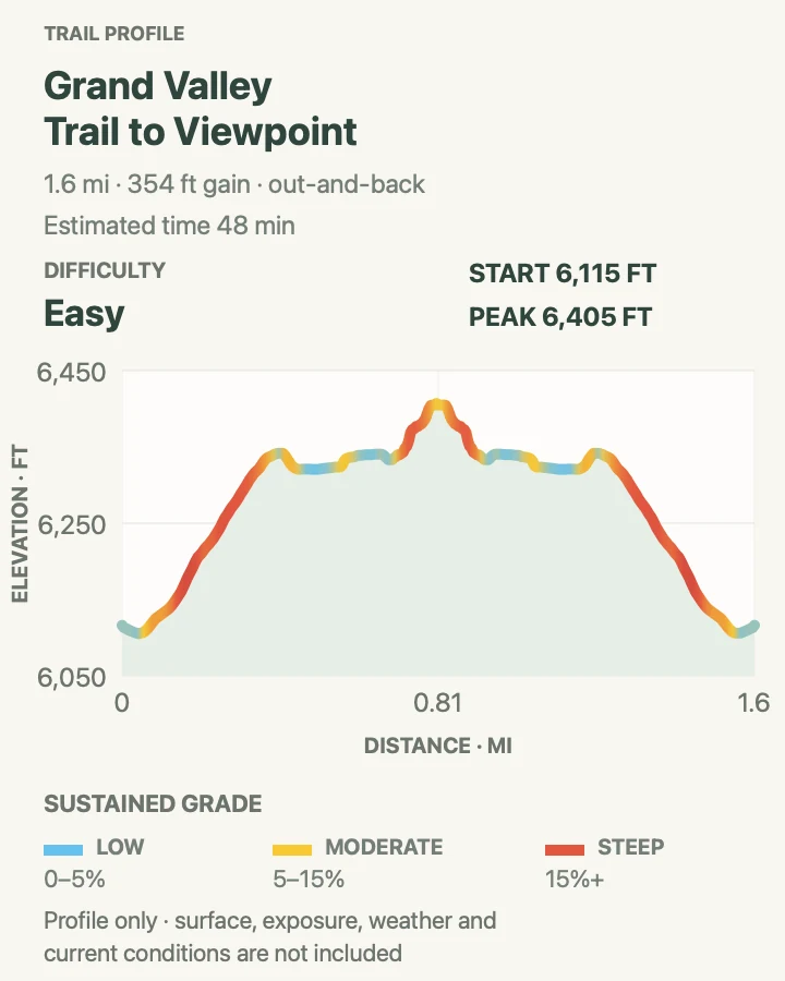
| Grand Valley Trail to Viewpoint | About 1.6 miles out and back | 48 min | Easy | A short alpine sample above Grand Valley without descending to the lakes |
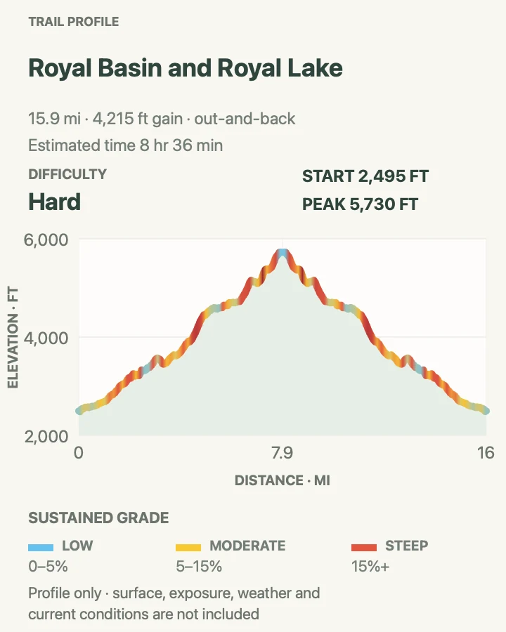
| Royal Basin and Royal Lake | About 16.1 miles out and back on the reviewed route | 8 hr 36 min | Hard | A hard full day or overnight into the park's northeast alpine basin |
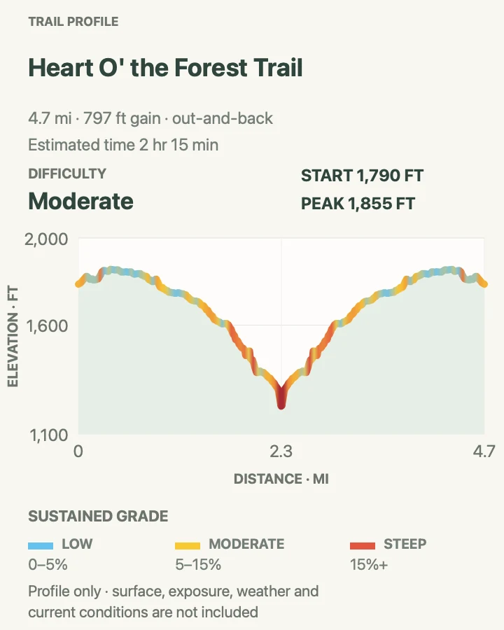
| Heart O' the Forest Trail | About 4.7 miles out and back | 2 hr 15 min | Moderate | A long low-elevation forest walk close to Port Angeles |
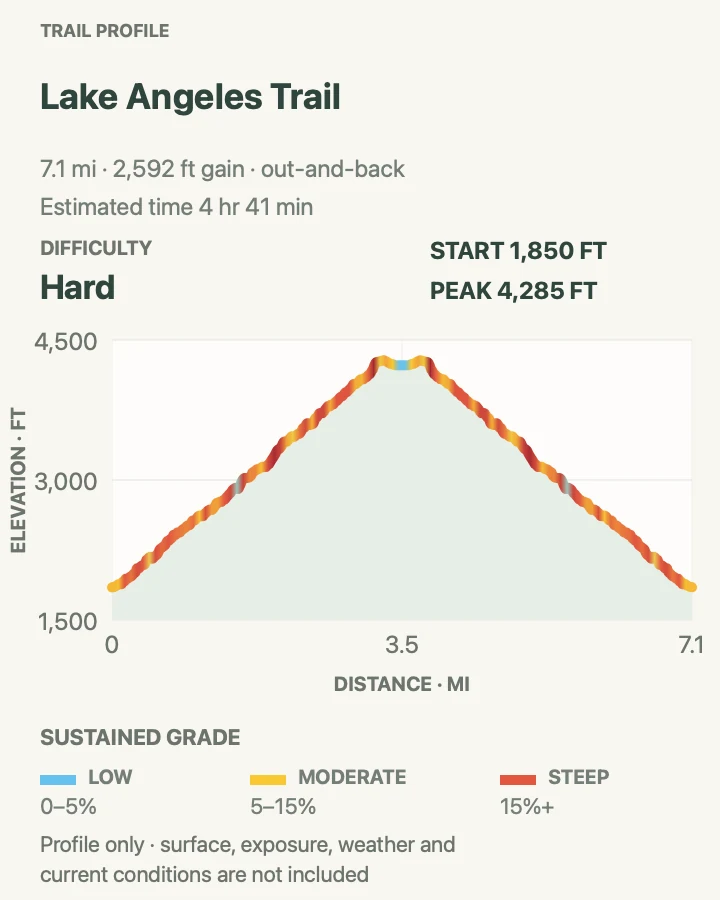
| Lake Angeles Trail | About 7.2 miles out and back | 4 hr 41 min | Hard | A sustained forest climb to a subalpine lake |
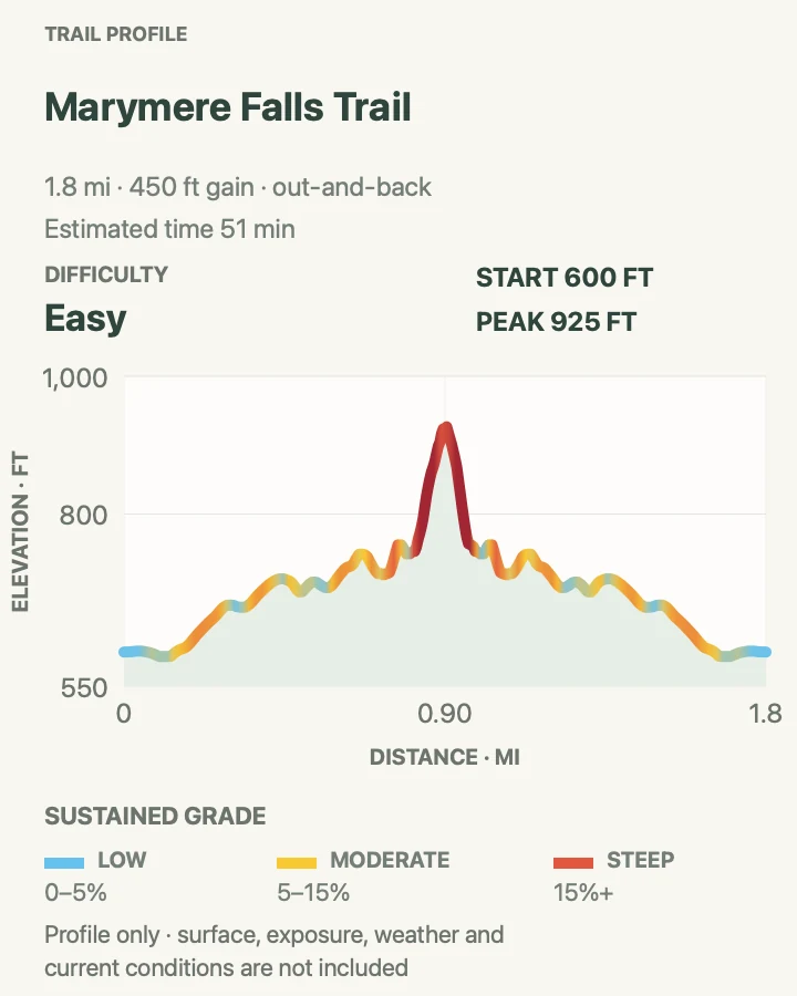
| Marymere Falls Trail | About 1.8 miles out and back | 51 min | Easy | A short old-growth walk and waterfall without the Storm King climb |
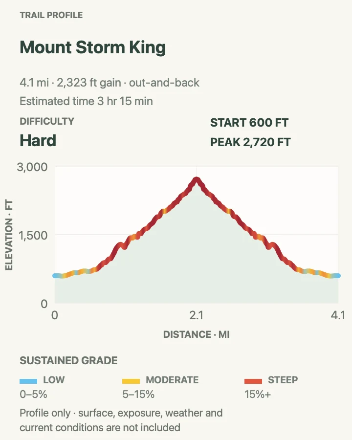
| Mount Storm King | About 4.4 miles out and back from Lake Crescent Lodge | 3 hr 15 min | Hard | A hard, steep climb above Lake Crescent for hikers comfortable with exposure |
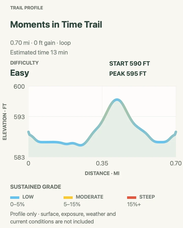
| Moments in Time Trail | 0.7-mile reviewed loop; 0.8 mile by NPS | 13 min | Easy | A very short forest-and-lakeshore walk for a mixed-ability group |
| Sol Duc Falls | About 1.8 miles out and back | 47 min | Easy | A short forest route to a slot-canyon waterfall |
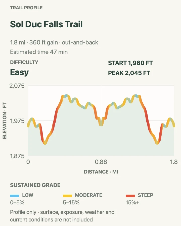
| Ancient Groves Nature Trail | 0.5-mile reviewed loop; about 0.6 mile by NPS | 12 min | Easy | A short old-growth loop away from the falls trailhead |
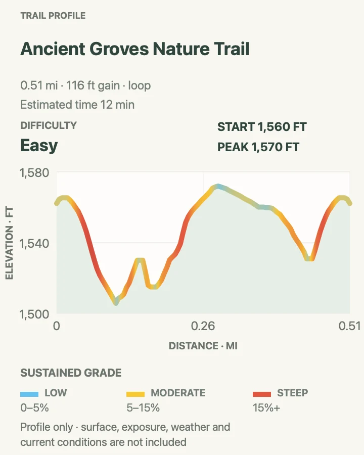
| Deer Lake Trail | About 7.4 miles out and back | 5 hr | Moderate | A hard lake day that samples the lower High Divide route |
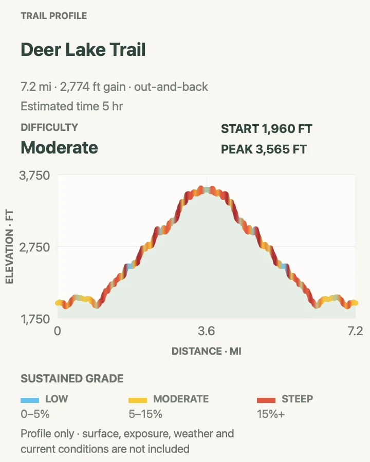
| High Divide and Seven Lakes Basin Loop | 18.2-mile NPS loop; about 22 miles on the reviewed longer geometry | 12 hr 51 min | Hard | A demanding backpacking loop with lakes, ridges, and Mount Olympus views |
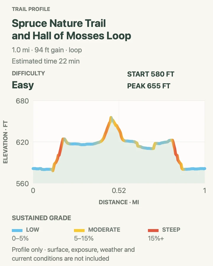
| Hall of Mosses and Spruce Nature Trail | About 2 miles for both complete NPS loops; 1 mile on the reviewed linked track | 22 min | Easy | A first rain-forest walk with moss, huge spruce, river habitat, and minimal mileage |
| Mineral Creek Falls via Hoh River Trail | About 5.6 miles out and back | 1 hr 48 min | Easy | A longer Hoh walk with a waterfall as a clean turnaround |
| 5-Mile Island via Hoh River Trail | About 10.2 miles out and back | 3 hr 16 min | Moderate | A full Hoh River day with a named river-bar turnaround |
| Hoh River Trail to Blue Glacier | About 35.4 miles out and back on the reviewed route | Varies | Hard | A multi-day Hoh backpack to the Mount Olympus and Blue Glacier viewpoint |
| South Fork Hoh Trail | About 8.1 miles out and back to the end of maintained trail | 3 hr | Moderate | A quieter river-forest day away from the Hoh visitor-center queue |
| Maple Glade Nature Trail | 0.5-mile loop | 9 min | Easy | A quiet half-mile forest loop for a mixed-ability group |
| Enchanted Valley via East Fork Quinault River Trail | About 25.6 miles out and back | 10 hr 43 min | Hard | A two- or three-day river-valley backpack with cliffs, waterfalls, and the chalet exterior |
| Ruby Beach | About 1.1 miles out and back, depending on beach wandering | 23 min | Easy | Sea stacks, driftwood, tide pools, and the only pet-friendly route in this list |
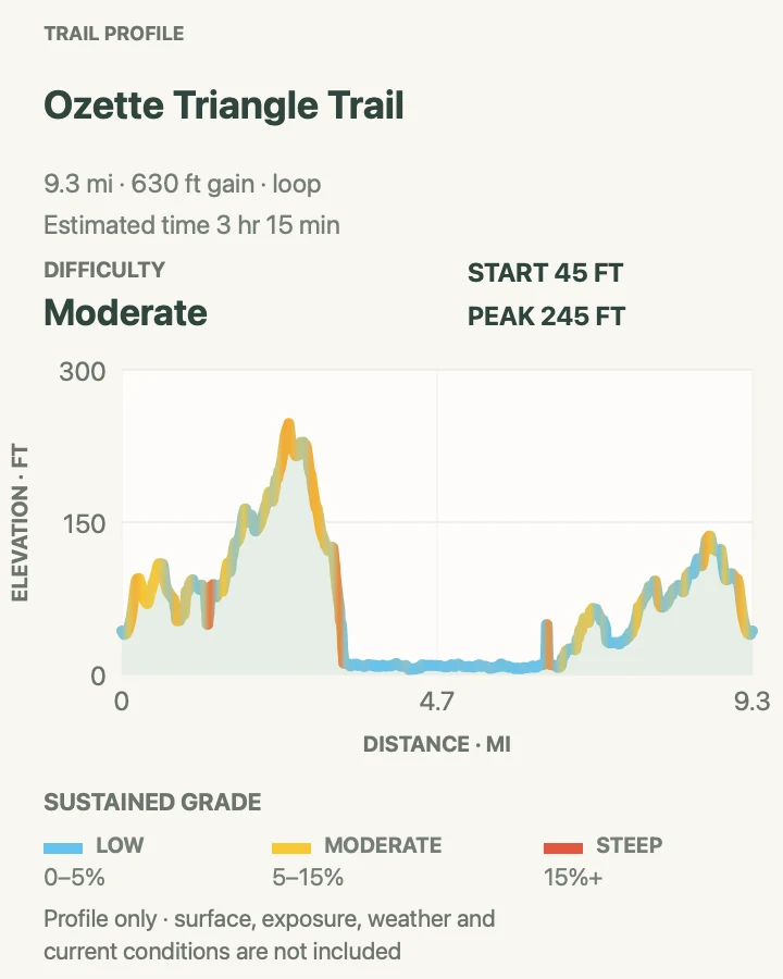
| Ozette Triangle | About 9.2 miles by NPS; 9.4 miles on the reviewed loop | 3 hr 15 min | Moderate | A full-day loop combining cedar boardwalk, Pacific coast, headlands, and Lake Ozette |
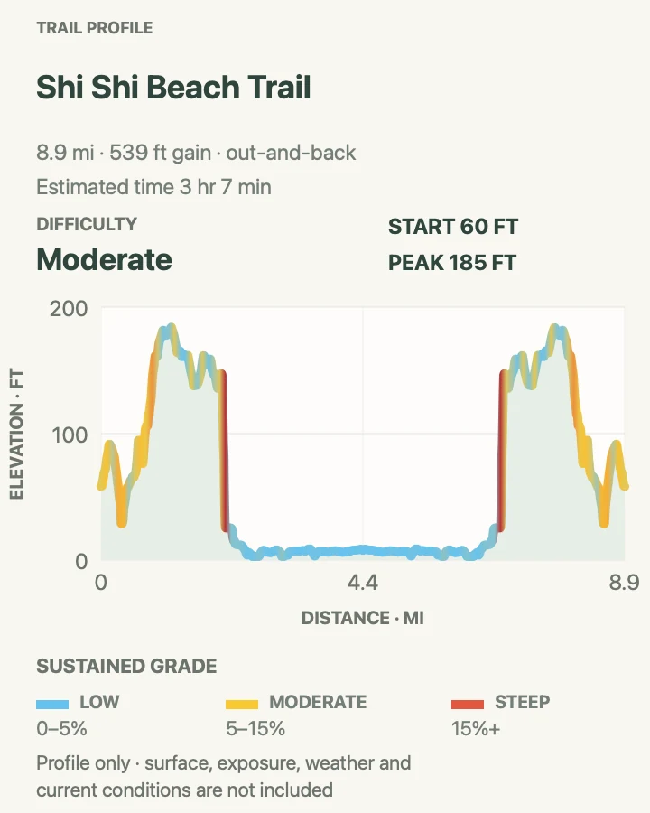
| Shi Shi Beach to Point of Arches | About 8.9 miles out and back on the reviewed route | 3 hr 7 min | Moderate | A long beach day to Point of Arches, with mud, surf, and remote coast |
Hurricane Hill via Hurricane Ridge
- Distance
- About 3.2 miles by NPS; 3.5 miles on the reviewed track
- Elevation gain
- 1,040 feet
- Time
- 1 hr 50 min
- Difficulty
- Moderate
- Route type
- out-and-back
- Parking
- Use the small Hurricane Hill trailhead lot at the end of Hurricane Hill Road; Picnic Area B is the official overflow option.
- Best time
- A clear morning from July into early fall, after checking road and wind conditions.
- Pets
- Pets are prohibited on the trail.
Hurricane Hill begins at roughly 5,200 feet and spends little time pretending to be flat. The first half mile is gentler. Beyond it, sustained grades climb through open meadow before the crest opens views across the Olympic Mountains, Strait of Juan de Fuca, and Vancouver Island on a clear day.
NPS describes a 1.6-mile one-way trail with about 700 feet of net gain. The reviewed line measures 3.5 miles round trip and counts every rise in both directions. Pavement does not remove the steep side slope, wind, or fast-moving cloud. There is no potable water at Hurricane Ridge during the 2026 utility project.
What helps on this route
- Check the Hurricane Ridge webcam and road recording before the 17-mile drive uphill.
- Stay on the paved line through meadow and give wildlife ample room.
Terrain and access: Paved mountain path, long steep grades, exposed side slopes, little shade, wind, and changing cloud.

Sunrise View Point via High Ridge Nature Trail
- Distance
- 0.9-mile loop on the reviewed track
- Elevation gain
- 260 feet
- Time
- 29 min
- Difficulty
- Moderate
- Route type
- loop
- Parking
- Park in the Hurricane Ridge visitor-area lots and begin beside the meadow paths.
- Best time
- A clear, calm morning when the ridge road is open.
- Pets
- Pets are prohibited on the trail.
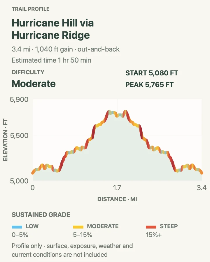
High Ridge climbs directly above the Hurricane Ridge parking area, circles meadow and low subalpine forest, and adds the short Sunrise Point spur. NPS lists a half-mile loop with roughly 220 feet of gain plus a 0.1-mile spur. The reviewed geometry measures 0.9 mile and about 265 feet of cumulative climbing.
The small mileage can disguise sharp pitches. Several sections are steep enough to demand deliberate footing, and the open slope catches wind. This is a compact mountain walk rather than a level visitor-center stroll.
What helps on this route
- Walk the loop in the direction that keeps oncoming traffic visible on narrow sections.
- Carry a layer even when Port Angeles is warm.
Terrain and access: Partly paved meadow path, short steep pitches, open wind, and about 265 feet of cumulative ascent.

Mount Angeles via Hurricane Ridge Trail
- Distance
- About 5.8 miles out and back
- Elevation gain
- 2,380 feet
- Time
- 4 hr 11 min
- Difficulty
- Moderate
- Route type
- out-and-back
- Parking
- Use the Hurricane Ridge visitor-area lots and start from the signed ridge trail network.
- Best time
- After snow has cleared, on a dry day with good mountain visibility.
- Pets
- Pets are prohibited on the trail.
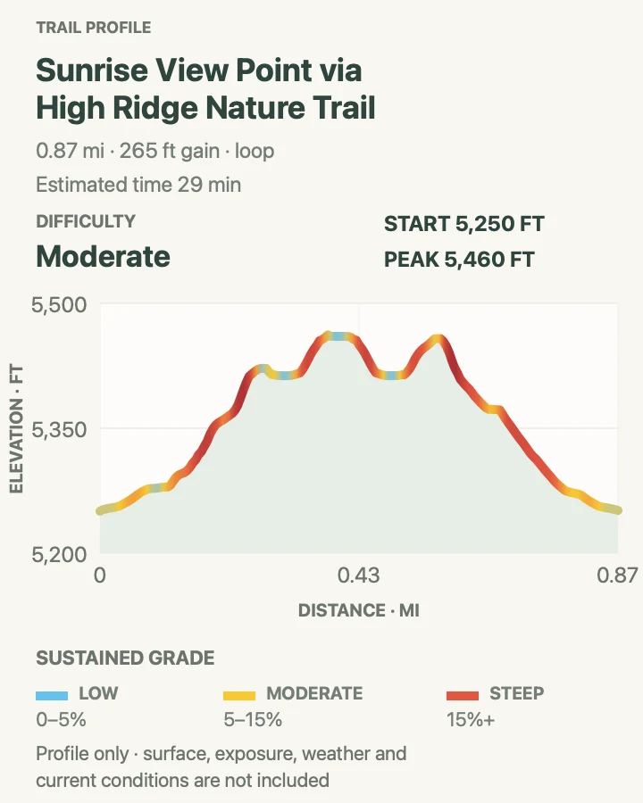
This reviewed route leaves the developed Hurricane area, crosses rolling ridge ground, and climbs toward Mount Angeles. The profile records about 2,380 feet of cumulative ascent in 5.8 miles because both the approach and summit section rise and fall.
Loose tread, exposed slopes, and lingering snow can matter more than the average grade. Cloud can also erase easy visual bearings along the ridge. Treat the summit as optional when rock is wet, wind is building, or snow covers the traverse.
What helps on this route
- Save an offline map before leaving the visitor area; route junctions multiply near the ridge.
- Set a weather turnaround as well as a clock turnaround.
Terrain and access: Rolling alpine tread, steep summit climbing, loose rock, exposure, possible snow, and about 2,380 feet of cumulative ascent.

Klahhane Ridge via Switchback Trail
- Distance
- About 3.1 miles out and back
- Elevation gain
- 1,520 feet
- Time
- 2 hr 25 min
- Difficulty
- Hard
- Route type
- out-and-back
- Parking
- Use the small Switchback Trail pullout on Hurricane Ridge Road only when all wheels fit within a legal space.
- Best time
- Mid- to late summer after snow clears, on a stable day without strong wind.
- Pets
- Pets are prohibited on the trail.
Switchback Trail wastes no distance reaching Klahhane Ridge. The reviewed line gains about 1,520 feet in 1.5 miles, then gives it back on the same set of turns. Much of the route is fully exposed to sun, wind, and cloud.
NPS describes an 800-foot climb over the final mile from the ridge-trail junction; this track starts lower and includes the entire switchback approach. Snow on the upper slope changes the outing from a steep hike to terrain that may require an ice axe and self-arrest skill.
What helps on this route
- Do not create a roadside hazard when the tiny pullout is full; choose another Hurricane route.
- Carry all water and sun protection.
Terrain and access: Relentless switchbacks, open slope, loose tread, exposure, possible steep snow, and about 1,520 feet of cumulative ascent.

Grand Valley Trail to Viewpoint
- Distance
- About 1.6 miles out and back
- Elevation gain
- 350 feet
- Time
- 48 min
- Difficulty
- Easy
- Route type
- out-and-back
- Parking
- Drive narrow gravel Obstruction Point Road to its trailhead; RVs and trailers should not use this road.
- Best time
- After Obstruction Point Road opens and early-season snow has retreated.
- Pets
- Pets are prohibited on the trail.
The route begins around 6,100 feet at Obstruction Point and follows the first stretch of the Grand Valley Trail to a turnaround above the basin. It measures only 1.6 miles, but the open ridge provides mountain scale almost immediately.
The profile records about 350 feet of cumulative climbing. The larger commitment is the road: it is narrow, gravel, and edged by steep drop-offs. Snow and cloud arrive sooner here than in Port Angeles, so a short trail still needs an alpine decision.
What helps on this route
- Check Obstruction Point Road status immediately before departure.
- Turn around at the mapped viewpoint; continuing to Grand Lake creates a much longer descent and return climb.
Terrain and access: Open subalpine tread, loose gravel, strong sun and wind, possible snow, and about 350 feet of cumulative ascent.

Royal Basin and Royal Lake
- Distance
- About 16.1 miles out and back on the reviewed route
- Elevation gain
- 4,220 feet
- Time
- 8 hr 36 min
- Difficulty
- Hard
- Route type
- out-and-back
- Parking
- Start at the USFS Upper Dungeness trailhead; a Northwest Forest Pass or America the Beautiful Pass is required.
- Best time
- Early July through mid-October after checking snow and trail reports.
- Pets
- Pets are prohibited after the route enters Olympic National Park.
Royal Creek leads from forest into Royal Lake and a basin ringed by high Olympic peaks. NPS lists 7.2 miles one way to Royal Lake; the reviewed route continues into the basin and totals 16.1 miles with about 4,220 feet of cumulative ascent.
Camping is quota-controlled from May through September, bear canisters are required, and campfires are prohibited. The current trail table reports the path snow-free to Royal Lake, problematic rodents around food, and no self-pay parking box at the trailhead. Peaks above the basin involve rotten rock and are outside this hike.
What helps on this route
- Carry the parking pass before driving to the remote trailhead.
- Keep food secured during daytime stops as well as overnight.
Terrain and access: Long forest approach, creek crossings, sustained climb, alpine basin, possible snow, and about 4,220 feet of cumulative ascent.

Heart O' the Forest Trail
- Distance
- About 4.7 miles out and back
- Elevation gain
- 800 feet
- Time
- 2 hr 15 min
- Difficulty
- Moderate
- Route type
- out-and-back
- Parking
- Begin in Loop E at Heart O' the Hills Campground, near the Hurricane Ridge entrance road.
- Best time
- Year-round when the campground access and trail are open.
- Pets
- Pets are prohibited on the trail.
Heart O' the Forest runs 2.3 miles one way through low-elevation forest from the campground to the park boundary. The path is broad in places and far quieter than the paved paths high above it.
NPS calls the route level, while the reviewed profile records about 800 feet of cumulative movement over the full out-and-back. That total comes from repeated small rises and a central dip rather than one mountain climb. Roots, wet tread, and a long return still count.
What helps on this route
- Confirm campground access before relying on the Loop E start.
- Use a time turnaround if you do not need to reach the park boundary.
Terrain and access: Shaded forest tread, roots, damp soil, repeated small rises, and about 800 feet of cumulative ascent.

Lake Angeles Trail
- Distance
- About 7.2 miles out and back
- Elevation gain
- 2,590 feet
- Time
- 4 hr 41 min
- Difficulty
- Hard
- Route type
- out-and-back
- Parking
- Drive to the public Lake Angeles and Heather Park trailhead at the end of Heart O' the Hills Road.
- Best time
- Early July through October; the lake route often melts out earlier than the ridge above it.
- Pets
- Pets are prohibited on the trail.
Lake Angeles climbs from about 1,850 feet to a lake basin near 4,250 feet. The reviewed line measures 7.2 miles and records roughly 2,590 feet of cumulative ascent, close to the official 3.5-mile one-way description.
The trail is maintained, but spring snow can hide sections above the lake and make the continuation toward Klahhane Ridge serious. Bear canisters are required for camping, and fires are prohibited at the lake. A day hike ends cleanly at the water rather than drifting onto the ridge connector.
What helps on this route
- Do not park beside private housing passed before the public trailhead.
- Treat lake water and carry a layer for the cooler basin.
Terrain and access: Sustained forest climb, roots and rock, subalpine basin, possible spring snow, and about 2,590 feet of cumulative ascent.

Marymere Falls Trail
- Distance
- About 1.8 miles out and back
- Elevation gain
- 450 feet
- Time
- 51 min
- Difficulty
- Easy
- Route type
- out-and-back
- Parking
- Use the Barnes Point or Lake Crescent Lodge parking area and follow the signed falls approach.
- Best time
- Year-round when the Lake Crescent area is open, with stronger flow after wet weather.
- Pets
- Pets are prohibited on the trail.
The path crosses beneath large conifers, passes the Storm King junction, and reaches a short loop below 90-foot Marymere Falls. Footbridges and steps arrive near the end. The lower viewpoint avoids the upper flight while still facing the falls.
The canonical reviewed route measures 1.8 miles and records about 450 feet of cumulative ascent. It replaces the lower-review lodge variant in this guide so the same destination is not counted twice. Wet boards, roots, and spray are the main complications.
What helps on this route
- Go early or late on summer weekends because Storm King and lodge visitors share the parking area.
- Use the signed viewpoints rather than scrambling beside the creek.
Terrain and access: Forest path, footbridges, roots, stairs, waterfall spray, and about 450 feet of cumulative ascent.

Mount Storm King
- Distance
- About 4.4 miles out and back from Lake Crescent Lodge
- Elevation gain
- 2,320 feet
- Time
- 3 hr 15 min
- Difficulty
- Hard
- Route type
- out-and-back
- Parking
- Use Barnes Point or Lake Crescent Lodge parking and follow the Marymere Falls approach to the signed junction.
- Best time
- A dry day from late spring through early fall; avoid ice, heavy rain, and low cloud.
- Pets
- Pets are prohibited on the trail.
Mount Storm King shares its opening with Marymere Falls, then turns uphill and keeps tightening. Forest switchbacks account for most of the maintained trail. Past the End of Maintained Trail sign, loose rock, severe grade, and exposure replace the ordinary path.
The reviewed profile records roughly 2,320 feet of cumulative climbing. NPS warns that ropes beyond the maintained section were placed by visitors, not installed or maintained by the park. A rope may be damaged, poorly anchored, or absent. The maintained-trail sign is a sound turnaround when rock is wet or exposure feels wrong.
What helps on this route
- Wear shoes that grip damp roots and loose dirt; save both hands for the upper terrain.
- Descend before fatigue makes the steep loose section harder than it was on the climb.
Terrain and access: Forest switchbacks, roots, loose rock, very steep unmaintained upper ground, serious exposure, and about 2,320 feet of cumulative ascent.

Moments in Time Trail
- Distance
- 0.7-mile reviewed loop; 0.8 mile by NPS
- Elevation gain
- 0 feet
- Time
- 13 min
- Difficulty
- Easy
- Route type
- loop
- Parking
- Use the Barnes Point or Lake Crescent Lodge area and start near the lodge.
- Best time
- Any open season, including a rainy or low-cloud day.
- Pets
- Pets are prohibited on the trail.
Moments in Time loops through old forest and reaches the Lake Crescent shore without borrowing the busier Marymere corridor. The reviewed profile is nearly flat; NPS records about nine feet of gain on its 0.8-mile description.
The hard-packed surface still includes roots and uneven spots. Interpretive signs point out nurse logs, snags, and traces of a massive Douglas-fir. It works well when a longer party splits for Storm King or Lake Angeles.
What helps on this route
- Give lodge guests and service vehicles room near the start.
- Expect roots even though the elevation card looks flat.
Terrain and access: Hard-packed forest loop, roots, short lake access, negligible climbing, and damp shade.

Sol Duc Falls
- Distance
- About 1.8 miles out and back
- Elevation gain
- 360 feet
- Time
- 47 min
- Difficulty
- Easy
- Route type
- out-and-back
- Parking
- Use the Sol Duc Falls trailhead at the end of Sol Duc Road, beyond the resort.
- Best time
- Spring through fall while Sol Duc Road is open, especially after rain or during autumn color.
- Pets
- Pets are prohibited on the trail.
Sol Duc Falls drops into a narrow gorge rather than over a broad wall. The trail reaches the footbridge above the main view after a mostly gentle forest mile. Spray and dark water make the bridge area slick.
The reviewed line measures 1.8 miles round trip with about 360 feet of cumulative climbing. Several longer routes continue beyond the falls, but this entry ends at the bridge.
What helps on this route
- Use the marked viewpoints instead of scrambling toward the gorge.
- A morning start helps with both parking and an unobstructed bridge view.
Terrain and access: Old-growth forest, compact dirt, roots, wet bridge decking, gorge edge, and about 360 feet of cumulative ascent.

Ancient Groves Nature Trail
- Distance
- 0.5-mile reviewed loop; about 0.6 mile by NPS
- Elevation gain
- 120 feet
- Time
- 12 min
- Difficulty
- Easy
- Route type
- loop
- Parking
- Use the signed roadside pullout about 8.8 miles up Sol Duc Valley Road.
- Best time
- While Sol Duc Road is open, including a damp day when higher ridges are in cloud.
- Pets
- Pets are prohibited on the trail.
Ancient Groves drops from a roadside pullout into old forest above the Sol Duc River, crosses small bridges, and rolls back to the start. The reviewed line is half a mile with about 115 feet of cumulative ascent.
NPS measurements show several brief 10-to-20-percent sections. The short distance and easy rating therefore do not mean level or wheelchair-ready. The loop earns its place by offering a distinct Sol Duc forest stop without the falls crowd.
What helps on this route
- Watch for the pullout before driving past it; there is little room to correct suddenly.
- Use care on wet bridge planks and short steep drops.
Terrain and access: Rolling forest loop, roots, short bridges, brief steep pitches, river edge, and about 115 feet of cumulative ascent.

Deer Lake Trail
- Distance
- About 7.4 miles out and back
- Elevation gain
- 2,770 feet
- Time
- 5 hr
- Difficulty
- Moderate
- Route type
- out-and-back
- Parking
- Start at the Sol Duc trailhead and pass Sol Duc Falls on the climb toward Deer Lake.
- Best time
- After snow clears, usually summer into early fall.
- Pets
- Pets are prohibited on the trail.
Deer Lake continues beyond Sol Duc Falls, climbs beside Canyon Creek, and reaches a forested lake around 3,600 feet. The reviewed route measures 7.4 miles and records about 2,770 feet of cumulative ascent.
The current trail table reports the path clear of downed trees to the lake. Camping requires a wilderness permit and bear canister, and fires are prohibited above 3,500 feet. Day hikers should stop at the lake unless they have planned a longer High Divide itinerary.
What helps on this route
- Do not use the short Sol Duc Falls time estimate for the longer lake day.
- Carry food securely even on a day hike in this bear corridor.
Terrain and access: Waterfall approach, sustained forest climb, roots and rock, lake basin, and about 2,770 feet of cumulative ascent.

High Divide and Seven Lakes Basin Loop
- Distance
- 18.2-mile NPS loop; about 22 miles on the reviewed longer geometry
- Elevation gain
- 7,630 feet
- Time
- 12 hr 51 min
- Difficulty
- Hard
- Route type
- loop
- Parking
- Start at the Sol Duc trailhead; wilderness permit quotas apply to camping in managed sites.
- Best time
- After high-country snow clears, usually mid- to late summer into early fall.
- Pets
- Pets are prohibited on the trail and in park wilderness.
High Divide joins the Sol Duc River corridor, Deer Lake, Seven Lakes Basin, Heart Lake, and an open ridge facing Mount Olympus. NPS describes the standard loop as 18.2 miles with about 3,050 feet of net gain. Most hikers spread it across one or two nights.
The reviewed geometry is longer at about 22 miles and records roughly 7,630 feet of cumulative ascent. Snow often remains into July. Bear canisters are required, camps in quota areas must match the permit, and the open ridge can lose visibility quickly in cloud.
What helps on this route
- Call the Wilderness Information Center when the permit itinerary and chosen geometry do not match cleanly.
- Carry navigation that works without a cellular signal.
Terrain and access: River forest, lakes, long switchbacks, exposed alpine ridge, lingering steep snow, and about 7,630 feet of cumulative ascent on the reviewed geometry.

Hall of Mosses and Spruce Nature Trail
- Distance
- About 2 miles for both complete NPS loops; 1 mile on the reviewed linked track
- Elevation gain
- 95 feet
- Time
- 22 min
- Difficulty
- Easy
- Route type
- loop
- Parking
- Use the Hoh Rain Forest Visitor Center lot; summer traffic is metered when the lot reaches capacity.
- Best time
- Before 8 a.m. or after 5 p.m. in summer, or during a quieter wet-season visit.
- Pets
- Pets are prohibited on Hoh trails.
Hall of Mosses makes a compact 0.8-mile loop beneath bigleaf maples and hanging epiphytes. The 1.2-mile Spruce loop reaches Taft Creek and the Hoh River through old and younger forest. Walk both complete NPS loops for roughly two miles.
The reviewed map follows a one-mile linked trace and should not be mistaken for both official loops. Its profile records less than 100 feet of climbing. Parking is the larger obstacle: summer entrance waits can reach two hours.
What helps on this route
- Choose Hall of Mosses for concentrated moss or Spruce for the river if time is tight.
- Do not stand on roots or leave tread to stage a photograph.
Terrain and access: Compacted forest trail, roots, steps, short steep pitches, seasonal mud, wet wood, and little climbing.

Mineral Creek Falls via Hoh River Trail
- Distance
- About 5.6 miles out and back
- Elevation gain
- 450 feet
- Time
- 1 hr 48 min
- Difficulty
- Easy
- Route type
- out-and-back
- Parking
- Use the Hoh Rain Forest Visitor Center lot and account for entrance metering.
- Best time
- Spring through fall when Upper Hoh Road is open; early or evening starts are calmer in summer.
- Pets
- Pets are prohibited on the trail.
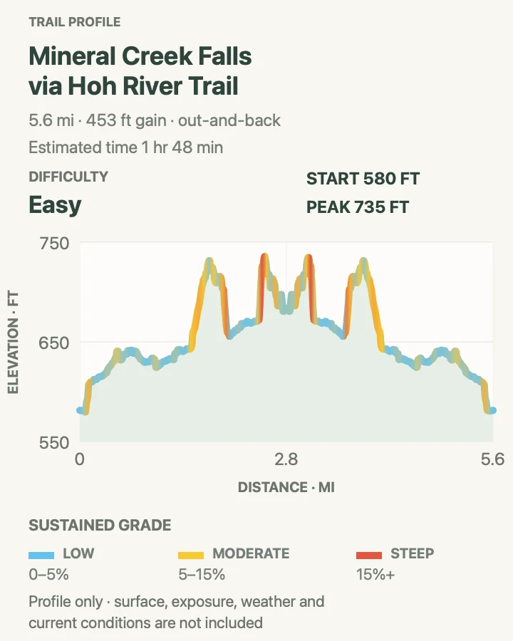
The Hoh River Trail heads toward Mount Olympus, but Mineral Creek Falls gives the first 2.7 miles a defined day-hike destination. The path stays in deep forest beside the river corridor and crosses several small streams.
The reviewed route measures 5.6 miles and records about 450 feet of cumulative ascent. Its difficulty comes from time, roots, mud, and wet footing rather than one climb. Five Mile Island is a separate ten-mile day.
What helps on this route
- Bring rain protection even when Forks has a dry forecast.
- Treat water from side streams before drinking.
Terrain and access: Low-gradient rain-forest tread, roots, mud, footbridges, small streams, and about 450 feet of cumulative ascent.

5-Mile Island via Hoh River Trail
- Distance
- About 10.2 miles out and back
- Elevation gain
- 590 feet
- Time
- 3 hr 16 min
- Difficulty
- Moderate
- Route type
- out-and-back
- Parking
- Use the Hoh Rain Forest Visitor Center lot and plan around summer entrance delays.
- Best time
- A long daylight window from late spring through fall when the Hoh road is open.
- Pets
- Pets are prohibited on the trail.
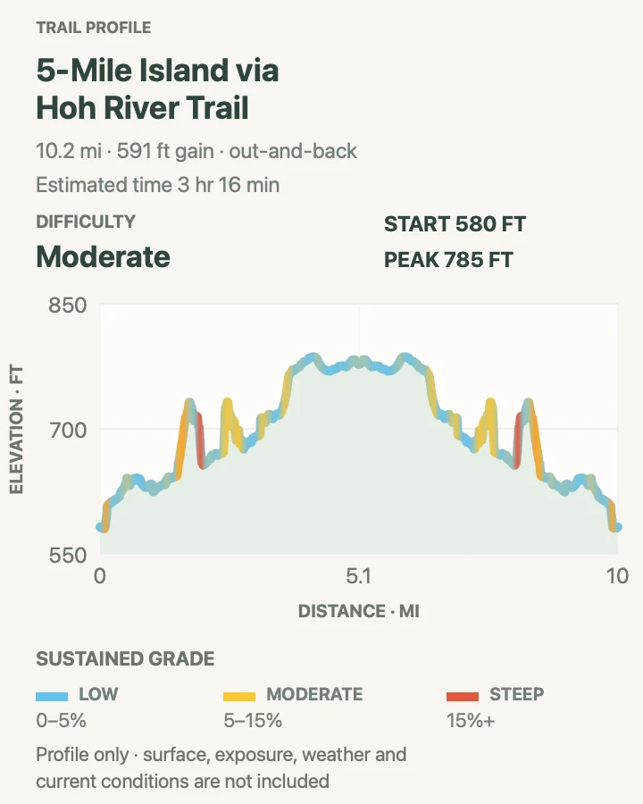
Five Mile Island extends the Hoh corridor beyond Mineral Creek Falls to camps and river bars roughly five miles from the visitor center. The reviewed track measures 10.2 miles and records about 590 feet of cumulative ascent, so pace depends on distance and footing.
The current NPS table reports that the stock hitching post has washed away. Hikers can still use the corridor, but any overnight requires a permit and bear canister. The pit toilet and camps do not turn this into a serviced front-country stop.
What helps on this route
- Write down a return time before the forest makes the miles feel interchangeable.
- Keep river-bar stops brief if rain is raising water levels.
Terrain and access: Long low-gradient rain-forest trail, roots, mud, side streams, river bars, and about 590 feet of cumulative ascent.

Hoh River Trail to Blue Glacier
- Distance
- About 35.4 miles out and back on the reviewed route
- Elevation gain
- 6,180 feet
- Time
- Varies
- Difficulty
- Hard
- Route type
- out-and-back
- Parking
- Start at the Hoh Rain Forest Visitor Center after accounting for summer entrance metering.
- Best time
- Late June through September after checking river crossings, snow, and the Glacier Meadows ladder.
- Pets
- Pets are prohibited on the trail and in park wilderness.
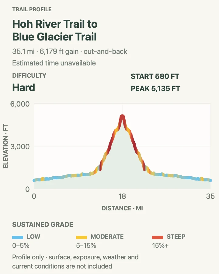
Blue Glacier turns the Hoh River Trail into a multi-day mountain journey. The first 13 miles remain comparatively low; the climb sharpens above Elk Lake toward Glacier Meadows and the lateral-moraine viewpoint. The reviewed out-and-back totals about 35.4 miles.
Current NPS reporting lists 37 downed trees, two fords before Olympus Guard Station, and three broken plus one missing rung on the ladder in the avalanche chute below Glacier Meadows. Camps in the upper corridor include quota sites, bear canisters are required, and the route to Mount Olympus beyond the viewpoint is technical mountaineering terrain.
What helps on this route
- Ask the Wilderness Information Center about the ladder and fords before finalizing an itinerary.
- Keep the glacier viewpoint separate from any plan to climb Mount Olympus.
Terrain and access: Long rain-forest corridor, fords, downed trees, steep upper trail, damaged ladder, snow and avalanche terrain, and multi-day mileage.

South Fork Hoh Trail
- Distance
- About 8.1 miles out and back to the end of maintained trail
- Elevation gain
- 630 feet
- Time
- 3 hr
- Difficulty
- Moderate
- Route type
- out-and-back
- Parking
- Use the South Fork Hoh trailhead reached by forest roads south of the main Hoh entrance.
- Best time
- A dry-enough road and trail day after checking the latest report.
- Pets
- Pets are prohibited on the trail.
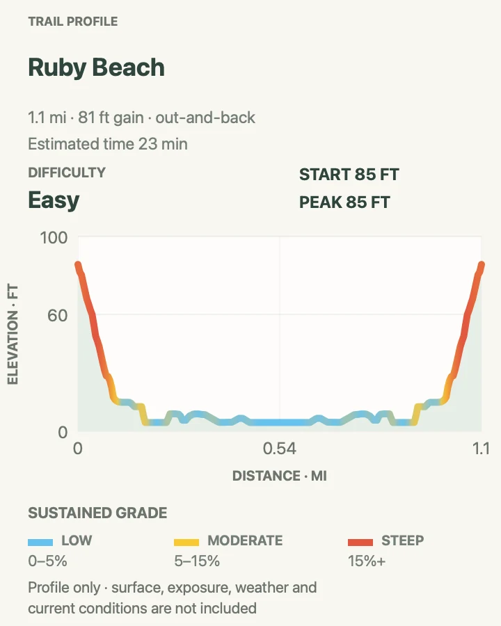
South Fork Hoh follows a different valley from the crowded visitor-center trails. The reviewed line runs 8.1 miles out and back, stays close to the river, and records about 630 feet of cumulative ascent.
NPS lists 4.2 miles from the trailhead to the end of maintained trail and currently has no recent field report. That absence is a reason to expect fallen trees, brush, mud, or road trouble rather than a claim that conditions are clear. Stop where maintained tread ends.
What helps on this route
- Download driving directions before leaving pavement and avoid committing a low-clearance car after road damage.
- Carry enough navigation to recognize the maintained-route endpoint.
Terrain and access: Remote forest road approach, river-valley tread, roots, mud, possible windfall, and about 630 feet of cumulative ascent.

Maple Glade Nature Trail
- Distance
- 0.5-mile loop
- Elevation gain
- 0 feet
- Time
- 9 min
- Difficulty
- Easy
- Route type
- loop
- Parking
- Start at the Quinault Rain Forest Ranger Station on North Shore Road.
- Best time
- Any open season, with the strongest wet-forest atmosphere during or just after rain.
- Pets
- Pets are prohibited on the trail.
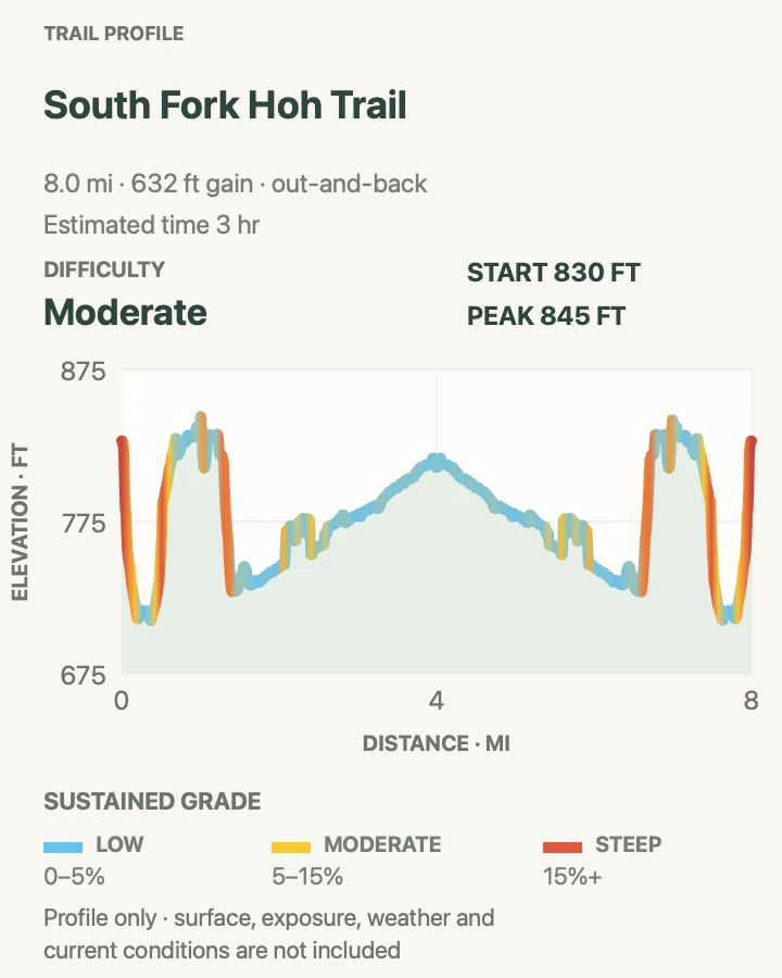
Maple Glade fits a giant Quinault forest into half a mile. Bigleaf maples, sword ferns, and moss crowd a gravel loop behind the ranger station. The reviewed elevation trace is effectively flat.
Bridges and compacted gravel make this one of the more mobility-friendly choices in the park. NPS notes that flooding can affect the route from October through May. A flat profile means no sustained hill, not guaranteed dry travel.
What helps on this route
- Pair the loop with Quinault road conditions rather than assuming access from the south side of the lake.
- After heavy rain, ask at the ranger station about water on the path.
Terrain and access: Compacted gravel, bridges, nearly level forest, possible seasonal flooding, and damp surfaces.

Enchanted Valley via East Fork Quinault River Trail
- Distance
- About 25.6 miles out and back
- Elevation gain
- 4,040 feet
- Time
- 10 hr 43 min
- Difficulty
- Hard
- Route type
- out-and-back
- Parking
- Reach Graves Creek from North Shore Quinault Road; RVs and trailers are prohibited on Graves Creek Road.
- Best time
- Late spring through early fall after checking river, washout, tree, and bear reports.
- Pets
- Pets are prohibited on the trail and in park wilderness.
The East Fork Quinault route follows a broad river valley from Graves Creek to Enchanted Valley. The old chalet is closed to entry and is not a backcountry lodge. NPS suggests two or three days for the roughly 13-mile one-way trip.
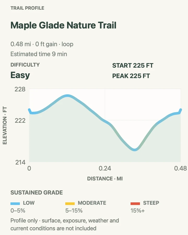
The reviewed line measures 25.6 miles and records about 4,040 feet of cumulative climbing. Current reporting notes a washout about one-third mile before the chalet and camps, possible fording or steep hillside route-finding, fourteen down trees between O'Neil Creek and the valley, and active bears. Bear canisters and a wilderness permit are required.
What helps on this route
- Drive to Graves Creek by North Shore Road; mapping software may still suggest the washed-out South Shore approach.
- Ask the Wilderness Information Center for the newest ford report.
Terrain and access: Long river-valley trail, roots and mud, fallen trees, possible ford, damaged trail, bear country, and about 4,040 feet of cumulative ascent.

Ruby Beach
- Distance
- About 1.1 miles out and back, depending on beach wandering
- Elevation gain
- 80 feet
- Time
- 23 min
- Difficulty
- Easy
- Route type
- out-and-back
- Parking
- Use the signed Ruby Beach lot off US 101.
- Best time
- Near low tide for tide pools and walking room, with daylight to return before the tide rises.
- Pets
- Leashed pets are allowed; use a leash no longer than six feet and remove waste.
A short forest descent reaches a driftwood berm, then the route becomes whatever safe stretch of beach the tide leaves open. Abbey Island and sea stacks give Ruby a distinct horizon. The reviewed line is a modest out-and-back, not a promise of fixed beach access.
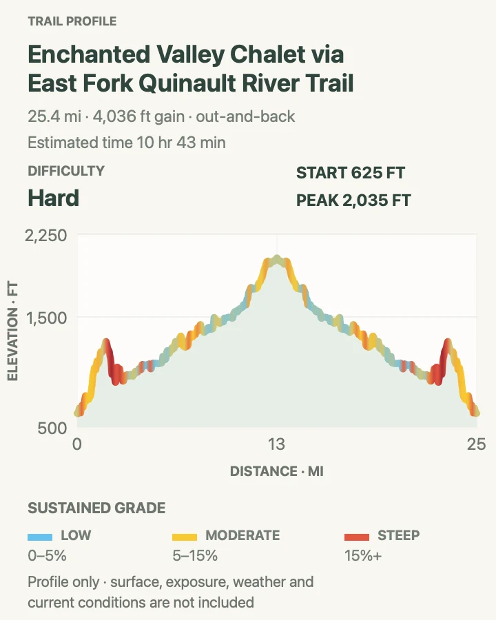
The profile records about 80 feet of cumulative climbing. Surf and wood are the larger hazards: sneaker waves reach farther than expected, and floating or stacked logs can roll. Keep children and dogs away from logs near the waterline.
What helps on this route
- Check tide and surf forecasts before leaving cell service.
- Bring footwear that can handle slick cobbles and wet sand.
Terrain and access: Short forest descent, driftwood barrier, sand and cobbles, tide pools, sneaker waves, and about 80 feet of cumulative ascent.

Ozette Triangle
- Distance
- About 9.2 miles by NPS; 9.4 miles on the reviewed loop
- Elevation gain
- 630 feet
- Time
- 3 hr 15 min
- Difficulty
- Moderate
- Route type
- loop
- Parking
- Start beside the Ozette Ranger Station at Lake Ozette.
- Best time
- A stable day with a tide window that makes the three-mile beach leg safe.
- Pets
- Pets are prohibited on the loop and wilderness coast.
Two boardwalk arms connect Lake Ozette to the coast: Cape Alava to the north and Sand Point to the south. The third side is about three miles of beach. Direction must follow the tide rather than habit.
NPS lists 9.2 miles; the reviewed line measures 9.4 and records about 630 feet of cumulative climbing. Boardwalk can be extremely slippery. The steep headland route north of Sand Point is treacherous, and ropes there are not maintained by NPS. Overnight trips need a permit and bear canister.
What helps on this route
- Carry a printed tide table and map with tidal restrictions.
- Slow down on wet boardwalk and step squarely.
Terrain and access: Long cedar boardwalks, roots, sand and cobbles, tide-limited beach, headland hazards, and about 630 feet of cumulative ascent.

Shi Shi Beach to Point of Arches
- Distance
- About 8.9 miles out and back on the reviewed route
- Elevation gain
- 540 feet
- Time
- 3 hr 7 min
- Difficulty
- Moderate
- Route type
- out-and-back
- Parking
- Start on the Makah Reservation. A Makah Recreation Pass is required; overnight parking is in designated private lots, not at the trailhead.
- Best time
- A low-tide window on a calm day, after confirming Makah access and park coastal conditions.
- Pets
- Pets are prohibited on Olympic's wilderness coastal routes.
Shi Shi begins on Makah land, follows a forest path that is often muddy, and drops to a broad beach. The reviewed 8.9-mile route continues south to Point of Arches before returning the same way.
The profile records about 540 feet of cumulative climbing, much of it on the forest approach. Soft sand, slick wood, and water detours add effort. A Makah Recreation Pass is separate from park admission. Camping also requires a wilderness permit and bear canister.
What helps on this route
- Confirm Makah access rules before the drive.
- Budget the return through mud and soft sand instead of using a paved-trail pace.
Terrain and access: Muddy forest approach, roots, steep beach access, soft sand, cobbles, driftwood, tides, surf, and about 540 feet of cumulative ascent.

Official planning sources
Trail access and safety details were checked against these National Park Service pages. The maps and profiles use the reviewed route geometry stored with this guide.
- NPS: Current Olympic alerts, access, and 2026 construction
- NPS: Current Olympic road conditions
- NPS: Current wilderness trail and coastal reports
- NPS: Olympic day-hiking distances
- NPS: Hurricane Ridge area trail distances
- NPS: Hurricane Hill trailhead and accessibility
- NPS: Obstruction Point trailhead
- NPS: Grand Valley
- NPS: Royal Basin
- NPS: Lake Angeles Trail
- NPS: Heart O' the Forest trailhead
- NPS: Moments in Time Trail
- NPS: Mount Storm King Trail
- NPS: Sol Duc Falls Trail
- NPS: Ancient Groves trailhead
- NPS: High Divide Loop
- NPS: Hoh Rain Forest trails and planning
- NPS: Hoh River Trail
- NPS: East Fork Quinault River Trail and Enchanted Valley
- NPS: Olympic beaches, surf, logs, and Ruby Beach pet access
- NPS: Olympic wilderness coast planning
- NPS: Ozette Triangle route and camping rules
- NPS: North Coast Route and Shi Shi requirements
- NPS: Olympic wilderness regulations
- NPS: Olympic pet rules
Map data © OpenStreetMap contributors. Trail geometry and planning details include National Park Service public information.