24 Best Hikes in Great Smoky Mountains National Park
Plan the best hikes in Great Smoky Mountains National Park with 24 curated routes, original terrain maps, elevation profiles, and live NPS alerts.
Great Smoky Mountains National Park rewards hikers who plan by landscape rather than chase a numbered list. These 24 routes cover the park’s essential experiences: high Appalachian ridges, major waterfalls, cool creek valleys, grassy balds, old-growth forest, and the human history preserved along former roads and homesites.
The hikes are grouped into six practical regions. A route near Deep Creek should not compete with a summit above Cosby when the drives begin on opposite sides of the mountains. Each section includes a comparison table, an original terrain map, and a measured elevation profile. Distances and times are planning estimates; weather, road access, water levels, and individual pace can change the day substantially.
Plan before you reach the trailhead
Choose a region, not a ranking. Great Smoky Mountains National Park is enormous. The best hike is usually the strongest route near the road corridor you are already using, with one nearby backup for weather, parking, or access changes.
Parking tags, entrance fees, and reservations
Great Smoky Mountains National Park does not charge an entrance fee, but vehicles parked for more than 15 minutes must display a valid parking tag. A tag does not reserve a space. Buy it before entering a low-service area and use only legal marked parking. Hiking the trails on this page does not require a timed-entry reservation, though campground, backcountry, and lodging plans have their own rules.
Road geography changes the plan
Newfound Gap Road is the only paved road across the park. Cades Cove, Roaring Fork, Greenbrier, Cosby, Cataloochee, Tremont, Elkmont, and Deep Creek sit on different approach roads, and a closure can turn a short map distance into a long detour. Build each day around one region. Download directions before leaving town and check the official current conditions plus the detailed road and trail status.
Weather, water, and mountain terrain
Elevation changes conditions quickly. Kuwohi and the Appalachian Trail can be cold, foggy, or icy while Cherokee and Gatlinburg are warm. Waterfalls and creek banks are never safe scrambling zones; fast current, cold water, and algae-slick rock cause serious accidents. Carry water, food, rain protection, a warm layer, a headlamp, and an offline map. On long routes, set a turnaround time rather than letting the destination decide for you.
Bears, elk, and food
Black bears live throughout the park, while elk are common around Oconaluftee and Cataloochee. Keep the required distance, never feed or approach wildlife, and back away if an animal changes behavior because of you. Carry food so odors stay contained and never leave a pack unattended. Wildlife warnings and temporary trail closures can appear separately from road notices, so read the official trail-condition page on the morning of the hike.
Dogs on Smokies trails
Pets are prohibited on almost every park trail. The only two exceptions are Gatlinburg Trail and Oconaluftee River Trail, where dogs must remain on a leash no longer than 6 feet. Of the 24 hikes below, only Oconaluftee River Trail allows dogs. Do not bring a pet onto another route because a third-party trail app labels it dog friendly.
Sugarlands, Roaring Fork, and Greenbrier
This Tennessee-side group contains two of the park's defining summit days and two waterfall hikes. Trailheads are spread between Newfound Gap Road, Roaring Fork, Cherokee Orchard, and Greenbrier, so treat them as separate outings rather than stops on one driving loop.
| Trail | Distance | Time | Difficulty | Best for |
|---|---|---|---|---|
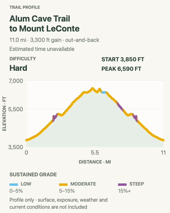
| Alum Cave Trail to Mount LeConte | 11.2 mi | 6 to 8 hours | Hard | The classic Mount LeConte summit day |
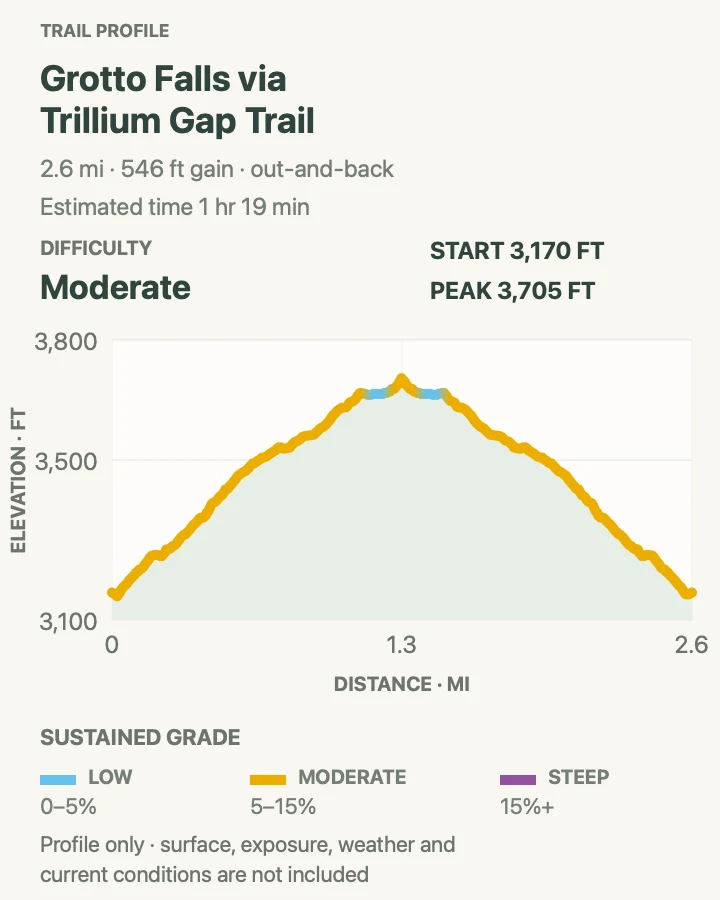
| Grotto Falls via Trillium Gap Trail | 2.7 mi | 1 hr 19 min | Moderate | A compact waterfall hike with an unusual walk-behind view |
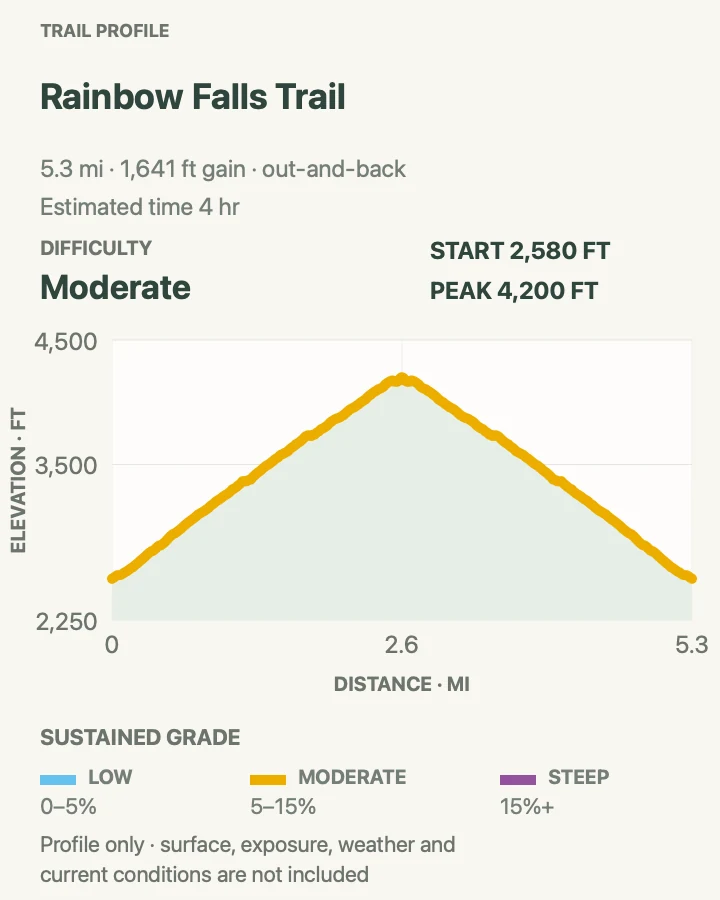
| Rainbow Falls Trail | 5.4 mi | 4 hr | Moderate | A sustained climb to the park's tallest single-drop waterfall |
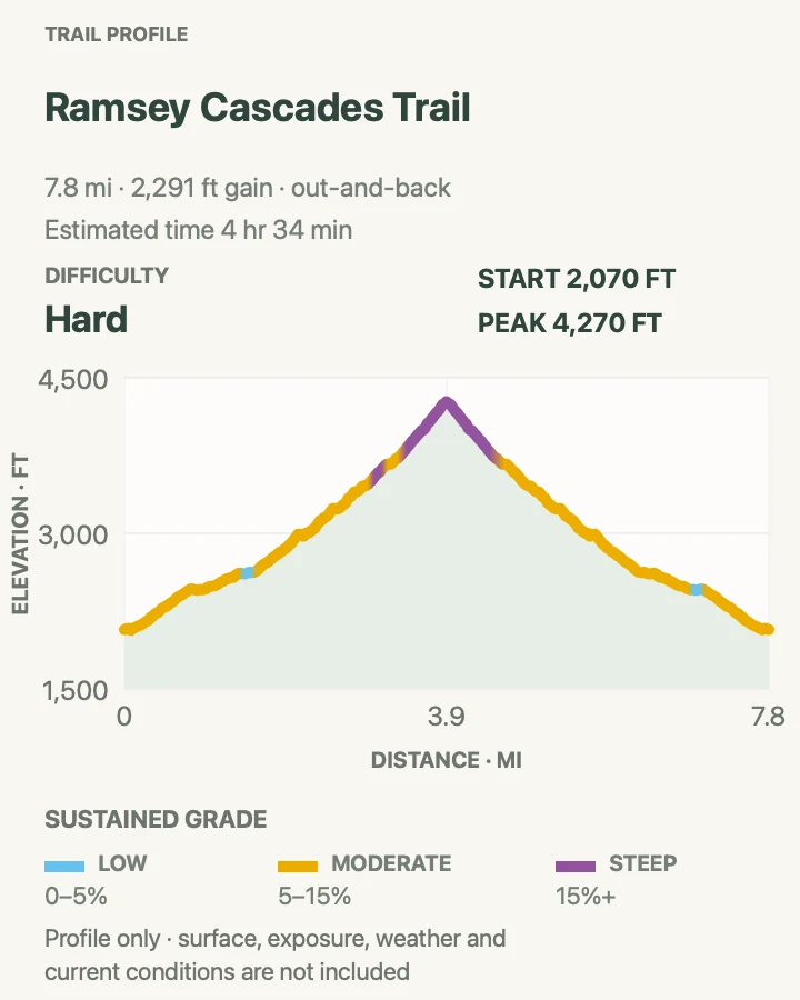
| Ramsey Cascades Trail | 7.9 mi | 4 hr 34 min | Hard | A demanding old-growth hike to a high backcountry cascade |
Alum Cave Trail to Mount LeConte
- Distance
- 11.2 mi
- Elevation gain
- 3,300 feet
- Time
- 6 to 8 hours
- Difficulty
- Hard
- Route type
- Out And Back
- Parking
- Alum Cave Trail parking areas on Newfound Gap Road; legal roadside spaces fill very early
- Best time
- At first light on a dry, settled day
- Pets
- Not allowed
Alum Cave Trail is the most varied route to Mount LeConte. It crosses log bridges over Alum Cave Creek, squeezes through Arch Rock, and reaches the broad overhang at Alum Cave Bluffs before the sustained upper climb begins.
The bluffs are a worthwhile turnaround in their own right. Beyond them, cable handholds assist on wet or icy ledges as the trail works toward LeConte Lodge. Because the summit itself is wooded, continue to Cliff Top or Myrtle Point if a view is part of the plan.
Busy does not mean easy here. The upper route can be cold, windy, or icy when the valley is mild, and the descent is long enough to expose a late start. Bring a headlamp and layers, then turn around if cloud or slick rock makes the higher traverses uncomfortable.

Grotto Falls via Trillium Gap Trail
- Distance
- 2.7 mi
- Elevation gain
- 546 feet
- Time
- 1 hr 19 min
- Difficulty
- Moderate
- Route type
- Out And Back
- Parking
- Trillium Gap trailhead on the one-way Roaring Fork Motor Nature Trail; spaces are extremely limited
- Best time
- Early morning when Roaring Fork Motor Nature Trail is open
- Pets
- Not allowed
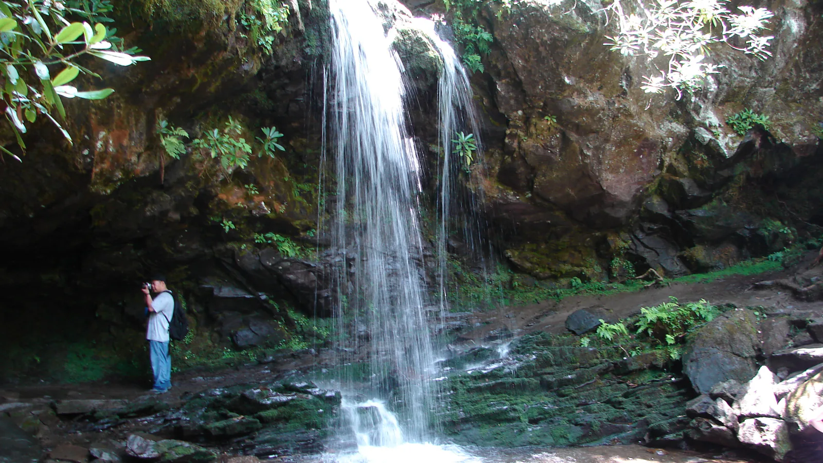
Grotto Falls is the park's rare waterfall where the maintained trail passes behind the falling water. Trillium Gap Trail climbs through hemlock and hardwood forest, crosses several small drainages, and reaches the 25-foot cascade in a rocky amphitheater. Wet roots and stones keep it from feeling like a paved attraction. The tiny roadside parking area is often the limiting factor, so arrive early and pass it by if every legal space is taken. Spray reaches the path even in clear weather; the waterfall is the turnaround unless you have deliberately planned the much longer Mount LeConte route.

Rainbow Falls Trail
- Distance
- 5.4 mi
- Elevation gain
- 1,641 feet
- Time
- 4 hr
- Difficulty
- Moderate
- Route type
- Out And Back
- Parking
- Rainbow Falls trailhead off Cherokee Orchard Road; overflow parking is limited to legal marked spaces
- Best time
- Morning, especially in warm weather
- Pets
- Not allowed
Rainbow Falls earns its name when afternoon sun and strong flow create color in the mist, but the hike is rewarding without the optical effect. The route climbs beside LeConte Creek through boulder-strewn forest, gaining elevation almost continuously before reaching the 80-foot drop. Expect stone steps, roots, and wet footing rather than an easy waterfall stroll.
Start early to avoid the hottest part of the ascent and the busiest period at the overlook. Stay on the official viewing side and never climb the wet rocks beside the falls; several serious accidents have happened there. The trail continues to Mount LeConte, but that extension turns a moderate waterfall hike into a long summit day and should be planned as a separate objective.

Ramsey Cascades Trail
- Distance
- 7.9 mi
- Elevation gain
- 2,291 feet
- Time
- 4 hr 34 min
- Difficulty
- Hard
- Route type
- Out And Back
- Parking
- Ramsey Cascades trailhead in Greenbrier; check Greenbrier Road access before driving in
- Best time
- A cool, dry morning with ample daylight
- Pets
- Not allowed
Ramsey Cascades is a steep, rugged waterfall hike through some of the park's most impressive old-growth forest. The first miles follow old road grade beside rushing water; the final approach becomes noticeably rougher, climbing over roots and large rocks toward the 100-foot cascade. Giant tulip trees, basswoods, and silverbells make the forest as memorable as the destination.
The last mile is the crux, and the return takes longer than many hikers expect. Carry more food and water than you would for a typical eight-mile hike, allow generous daylight, and avoid the route when high water or ice makes crossings and rocks hazardous. Do not climb the rocks at the cascade. They remain slick in dry-looking conditions and a fall would be difficult to reach.

Newfound Gap and the high country
The crest of the Smokies trades deep cove forest for spruce-fir woods, Appalachian Trail ridges, and broad views. Temperatures can be 10 to 20 degrees cooler than in Gatlinburg or Cherokee, and wind, fog, ice, and road closures can make a short high-country route the wrong choice on a given day.
| Trail | Distance | Time | Difficulty | Best for |
|---|---|---|---|---|
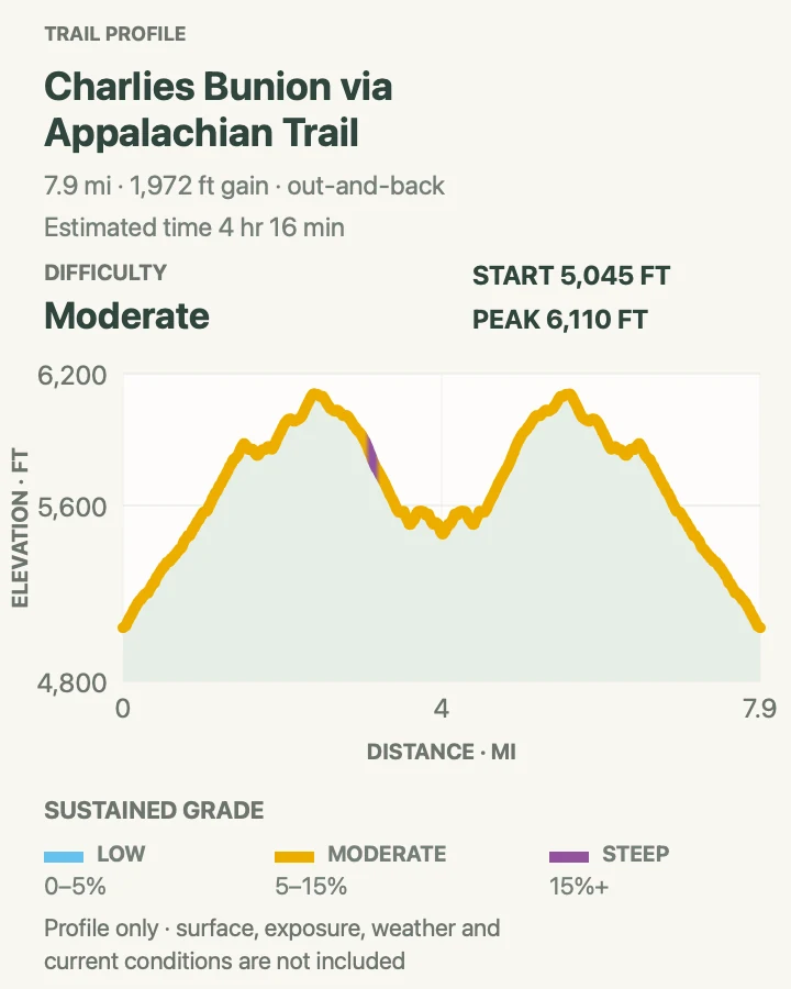
| Charlies Bunion via Appalachian Trail | 8 mi | 4 hr 16 min | Moderate | A ridgeline day with a dramatic rock viewpoint |
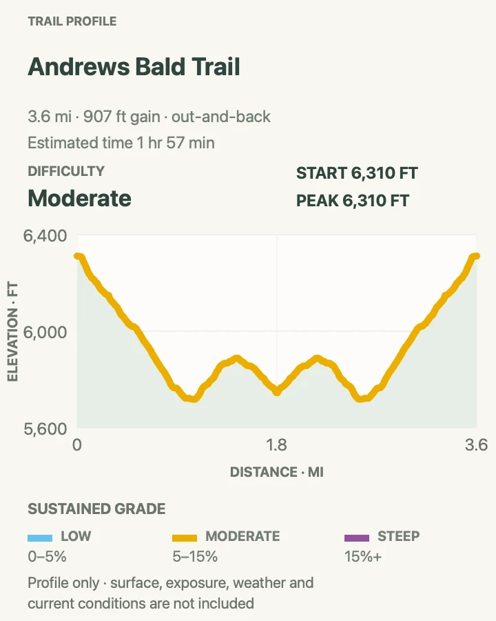
| Andrews Bald Trail | 3.6 mi | 1 hr 57 min | Moderate | A family-friendly high-elevation bald with mountain views |
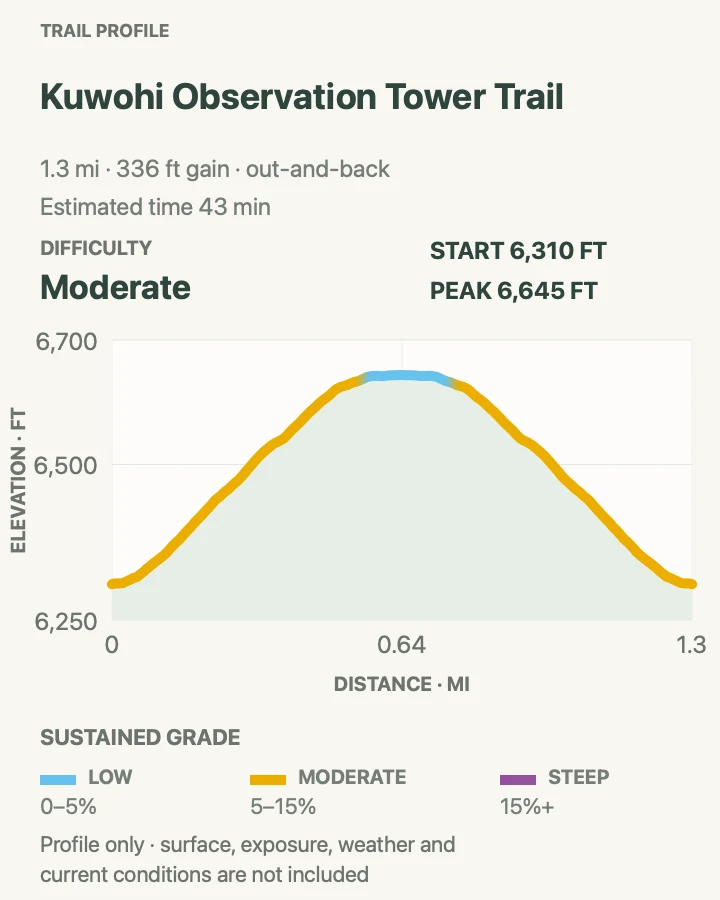
| Kuwohi Observation Tower Trail | 1.3 mi | 43 min | Moderate | The park's highest viewpoint on a short, steep walk |
| Mount Buckley via Kuwohi Bypass Trail | 1.7 mi | 1 to 1.5 hours | Moderate | A quieter high-country loop beside the Kuwohi crowds |
Charlies Bunion via Appalachian Trail
- Distance
- 8 mi
- Elevation gain
- 1,972 feet
- Time
- 4 hr 16 min
- Difficulty
- Moderate
- Route type
- Out And Back
- Parking
- Newfound Gap parking area; arrive early and carry a parking tag
- Best time
- A clear weekday morning outside icy periods
- Pets
- Not allowed
Charlies Bunion follows the Appalachian Trail east from Newfound Gap through spruce-fir forest and a series of ridge openings. A short spur near Icewater Spring Shelter leads to the final rocky viewpoint above the Tennessee valleys.
Do not let the net elevation figure undersell the day. The Appalachian Trail rolls enough that the return includes climbs many hikers forget on the way out, and colder months can leave ice in shaded sections.
The rocks at the Bunion have severe drop-offs. Stop well back from the edge in wind, fog, or crowded conditions. Newfound Gap also fills early; if there is no legal space or the ridge is already buried in cloud, choose a lower forest hike rather than forcing this one.

Andrews Bald Trail
- Distance
- 3.6 mi
- Elevation gain
- 907 feet
- Time
- 1 hr 57 min
- Difficulty
- Moderate
- Route type
- Out And Back
- Parking
- Kuwohi parking area at the end of Kuwohi Road; road access is seasonal and weather dependent
- Best time
- Morning in clear weather, or June for flame azalea
- Pets
- Not allowed
Andrews Bald descends from the Kuwohi parking area through spruce-fir forest on a carefully rebuilt path of stone and log steps. The open grassy bald arrives after most of the descent and frames layered views toward Fontana Lake and the southern Smokies. The return climb is the part that surprises people, especially after a long break in the sun.
This is one of the most approachable ways to experience the park's high country, but the trail can be muddy and the bald has little shelter from storms. Bring a warm layer and turn around if thunder develops. Stay on the durable path and open meadow rather than widening side tracks through sensitive vegetation. Combine it with the Kuwohi tower only if parking and weather remain favorable.

Kuwohi Observation Tower Trail
- Distance
- 1.3 mi
- Elevation gain
- 336 feet
- Time
- 43 min
- Difficulty
- Moderate
- Route type
- Out And Back
- Parking
- Large Kuwohi parking area; access road closes seasonally and can close for weather
- Best time
- Early morning or late afternoon on a clear day
- Pets
- Not allowed
The paved walk to Kuwohi Observation Tower is short but steep, climbing through the park's highest spruce-fir forest to a concrete ramp and a 360-degree view. Take it slowly after driving up from low elevation. The summit can be colder and windier than the parking lot, while cloud can erase the view completely. Kuwohi Road is seasonal and closes for weather, so verify access before the drive and stay on pavement, the tower ramp, and signed trails in this fragile high-elevation habitat.

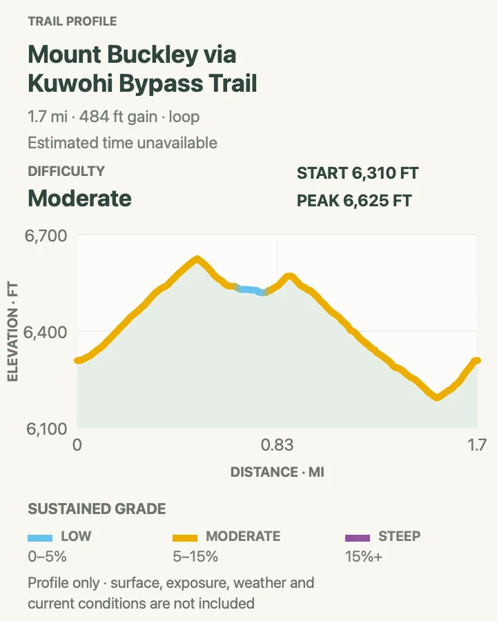
Mount Buckley via Kuwohi Bypass Trail
- Distance
- 1.7 mi
- Elevation gain
- 484 feet
- Time
- 1 to 1.5 hours
- Difficulty
- Moderate
- Route type
- Loop
- Parking
- Kuwohi parking area; use the signed bypass and Appalachian Trail connections
- Best time
- A clear, dry morning when Kuwohi Road is open
- Pets
- Not allowed
Mount Buckley is a compact way to leave the tower crowds and sample the Appalachian Trail. The loop uses the Kuwohi Bypass Trail and crest paths through dense spruce-fir forest, with brief openings and a more backcountry feel than the paved summit walk. It is not a substitute for a sweeping tower panorama; its appeal is the cool forest, ridge atmosphere, and quieter tread.
Junctions are close together, so download the route and match each turn to the map rather than following the largest group. Roots and rocks can be slick in fog, and the short mileage still includes a meaningful climb. Pair it with the observation tower for a fuller high-country visit, but skip the loop during thunderstorms, ice, or poor visibility.

Cades Cove and the Townsend side
The west side mixes waterfalls, historic valleys, quiet gravel roads, and one of the park's premier bald summits. Cades Cove traffic can dominate the schedule, while Tremont routes are easier to combine with a Townsend base. Check seasonal road access before choosing a distant trailhead.
| Trail | Distance | Time | Difficulty | Best for |
|---|---|---|---|---|
| Abrams Falls Trail | 5.1 mi | 2 hr 8 min | Moderate | A powerful waterfall reached from Cades Cove |
| Gregory Ridge Trail to Gregory Bald | 11.3 mi | 7 hr 30 min | Hard | A strenuous climb to a broad grassy summit |
| Buckeye Trail to Spruce Flats Falls | 1.7 mi | 1 to 1.5 hours | Moderate | A short, steep waterfall outing near Townsend |
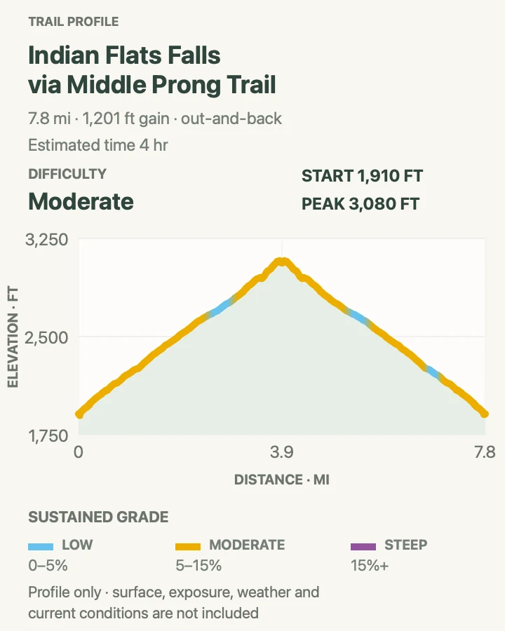
| Indian Flats Falls via Middle Prong Trail | 7.8 mi | 4 hr | Moderate | A long riverside walk with cascades and logging history |
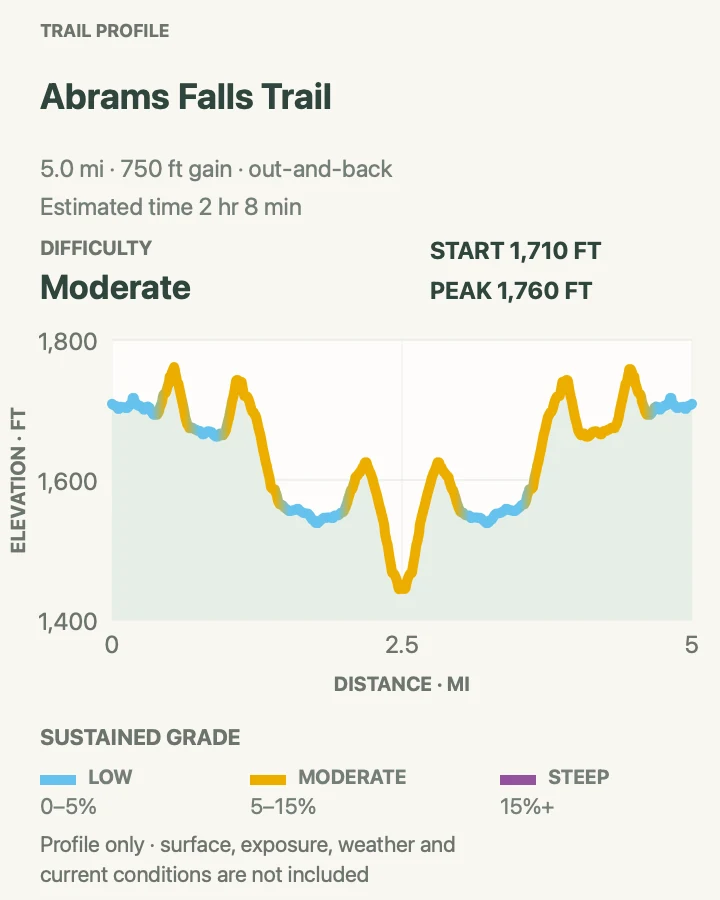
Abrams Falls Trail
- Distance
- 5.1 mi
- Elevation gain
- 750 feet
- Time
- 2 hr 8 min
- Difficulty
- Moderate
- Route type
- Out And Back
- Parking
- Abrams Falls trailhead off Cades Cove Loop Road; road and trail schedules can affect access
- Best time
- Early on a day when both the loop road and trail are open
- Pets
- Not allowed
Abrams Falls is only 20 feet high, but the volume of Abrams Creek makes it one of the park's most forceful cascades. The trail rolls over forested ridges from Cades Cove, with more climbing on the return than the walk to the falls may suggest. The broad pool and rock walls make a striking destination, especially after steady rain.
Never swim in the pool or scramble near the current. Powerful hydraulics, cold water, and hidden underwater hazards have caused fatalities. Access planning matters as much as the hike: Cades Cove has vehicle-free Wednesdays in season, and trail maintenance can add separate closure days. Confirm the live panel and official conditions before entering the loop road, then allow extra time for traffic and wildlife stops.

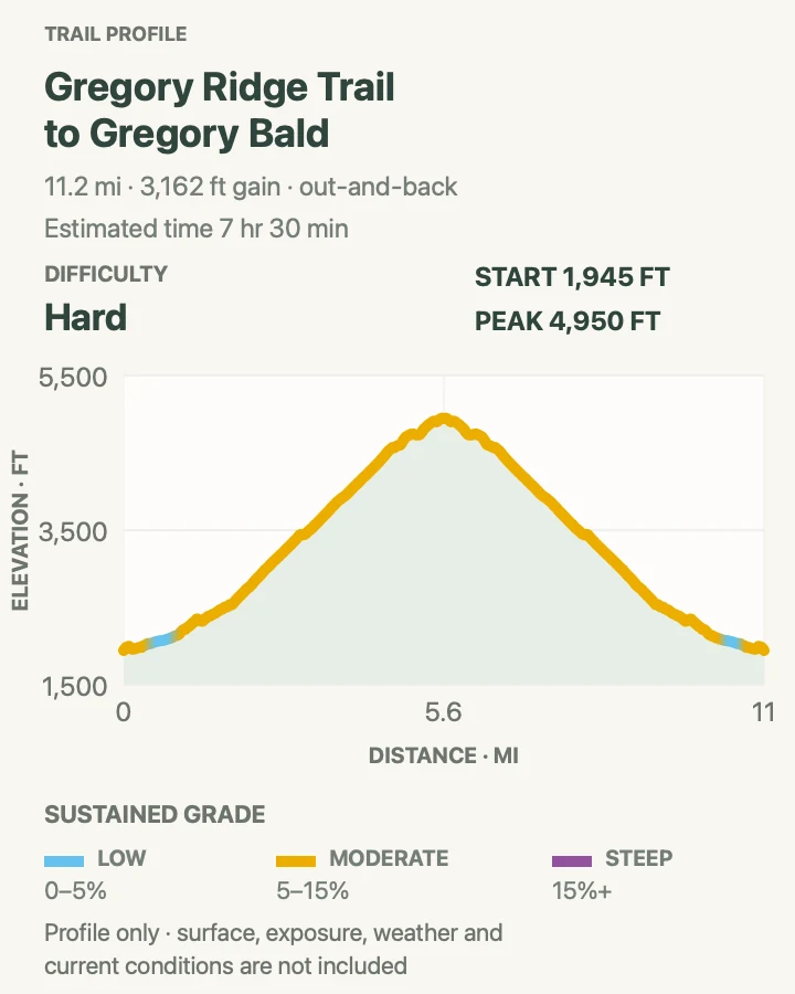
Gregory Ridge Trail to Gregory Bald
- Distance
- 11.3 mi
- Elevation gain
- 3,162 feet
- Time
- 7 hr 30 min
- Difficulty
- Hard
- Route type
- Out And Back
- Parking
- Gregory Ridge trailhead near the end of Forge Creek Road; access is seasonal
- Best time
- June for azalea bloom, or a clear cool day in spring or fall
- Pets
- Not allowed
Gregory Ridge Trail climbs steadily from the Cades Cove side through hardwood forest before reaching the open summit of Gregory Bald. From the grass, the view stretches across Cades Cove, Fontana Lake, and the surrounding ridges.
Flame azaleas draw the largest crowds in June. Outside bloom season, the open summit and long sightlines still justify the climb, especially on a cool day with clear air.
Plan for a full day. Forge Creek Road can be slow or seasonally closed, summer heat builds on the lower ridge, and the junctions near the bald warrant an offline map. Bears use the open high country, so keep food secured. During bloom, stay on durable paths instead of cutting through the shrubs for photographs.

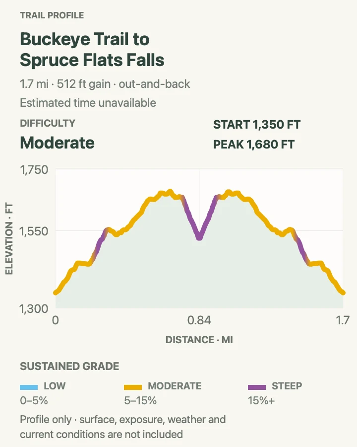
Buckeye Trail to Spruce Flats Falls
- Distance
- 1.7 mi
- Elevation gain
- 512 feet
- Time
- 1 to 1.5 hours
- Difficulty
- Moderate
- Route type
- Out And Back
- Parking
- Visitor parking at Great Smoky Mountains Institute at Tremont; follow local signs
- Best time
- Morning or after moderate rain, avoiding high water
- Pets
- Not allowed
Spruce Flats Falls packs a rugged hike into short mileage. The path climbs behind the Tremont campus, crosses a ridge, and descends sharply to a multi-tiered cascade in a boulder-filled gorge; roots, loose soil, and steep side slopes make the return climb harder than the distance implies. Follow the signed trail rather than informal tracks, view the falls from a stable bank, and remember that the parking area serves an active education center. If the trail is saturated or crowded, nearby Middle Prong provides a longer alternative with more room.

Indian Flats Falls via Middle Prong Trail
- Distance
- 7.8 mi
- Elevation gain
- 1,201 feet
- Time
- 4 hr
- Difficulty
- Moderate
- Route type
- Out And Back
- Parking
- Middle Prong trailhead at the end of Upper Tremont Road
- Best time
- Spring wildflowers, summer shade, or fall color
- Pets
- Not allowed
Middle Prong Trail follows an old railroad grade beside Lynn Camp Prong, passing cascades, side streams, and traces of the Little River Lumber Company. Indian Flats Falls sits beyond the busier early waterfalls, rewarding hikers who continue deeper into the drainage. The grade is moderate, but the out-and-back distance makes this a substantial half- to full-day outing.
Several unmarked side paths lead toward water or historic remnants. Keep the main route and downloaded map in view so a short detour does not become a wrong turn. The broad trail can be muddy after rain and stream edges remain slippery. Start early enough to enjoy the smaller cascades without rushing, and turn around at a planned time if Indian Flats is farther than the day's pace allows.

Elkmont and Metcalf Bottoms
Elkmont and the Little River corridor are the best part of this list for flexible mileage and cultural history. Two routes begin at the same Elkmont trailhead, while the Walker Sisters hike starts closer to Metcalf Bottoms. These are good alternatives when high ridges are in cloud.
| Trail | Distance | Time | Difficulty | Best for |
|---|---|---|---|---|
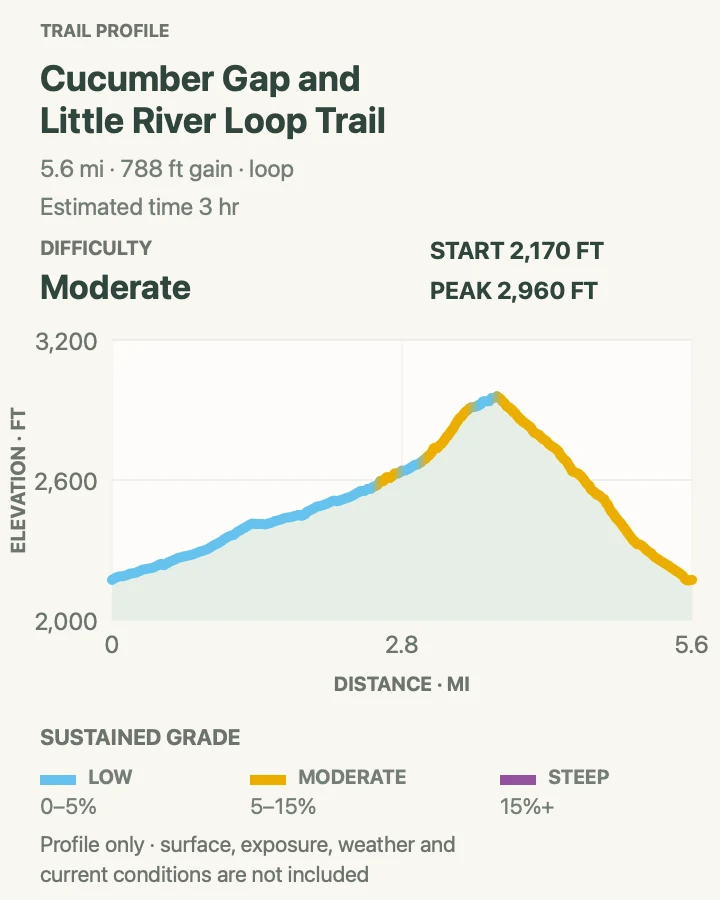
| Cucumber Gap and Little River Loop Trail | 5.6 mi | 3 hr | Moderate | A balanced loop of river, forest, and Elkmont history |
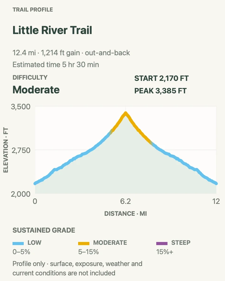
| Little River Trail | 12.5 mi | 5 hr 30 min | Moderate | A choose-your-own-distance river walk |
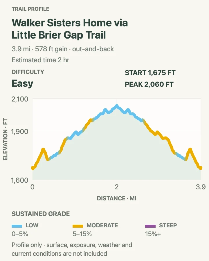
| Walker Sisters Home via Little Brier Gap Trail | 3.9 mi | 2 hr | Easy | A gentle walk into Smokies settlement history |
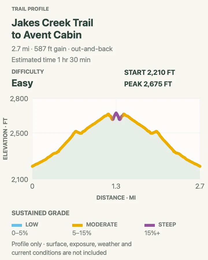
| Jakes Creek Trail to Avent Cabin | 2.7 mi | 1 hr 30 min | Easy | A quieter Elkmont walk to an artist's cabin |
Cucumber Gap and Little River Loop Trail
- Distance
- 5.6 mi
- Elevation gain
- 788 feet
- Time
- 3 hr
- Difficulty
- Moderate
- Route type
- Loop
- Parking
- Little River Trail parking area in Elkmont
- Best time
- Spring wildflowers or a cool fall morning
- Pets
- Not allowed
Cucumber Gap combines the gentle opening of Little River Trail with a real ridge crossing and a quiet return toward Elkmont. The loop passes old homesites and recovering forest, follows the river, then climbs through a saddle before descending along Jakes Creek. It offers more variety than a simple riverside out-and-back without requiring an all-day commitment.
Hike the loop clockwise if you prefer to warm up beside the river before climbing Cucumber Gap. Stream crossings and muddy sections can become awkward after heavy rain, so check conditions and use trekking poles if balance is a concern. Elkmont's junctions support several routes; note the correct turn in advance and do not rely on following other hikers, who may be headed toward a different cabin or backcountry campsite.

Little River Trail
- Distance
- 12.5 mi
- Elevation gain
- 1,214 feet
- Time
- 5 hr 30 min
- Difficulty
- Moderate
- Route type
- Out And Back
- Parking
- Little River Trail parking area in Elkmont
- Best time
- Any season with safe road access; especially spring wildflowers
- Pets
- Not allowed
Little River Trail begins on a broad former railroad grade and stays close to its namesake stream. The full route shown on the map is long, but this is one of the park's easiest hikes to scale: turn around at a cascade, Huskey Branch Falls, or any sensible time to create a shorter day. Historic stonework and old homesite traces add interest between river views.
The easy grade can tempt people to walk much farther than planned, so set a turnaround time and remember that the route rises gradually upstream. Rocks beside the river are slick and high water can make side streams hazardous. On a foggy or hot day, this shaded river corridor is a better bet than a distant viewpoint, though parking at Elkmont still fills on peak weekends.

Walker Sisters Home via Little Brier Gap Trail
- Distance
- 3.9 mi
- Elevation gain
- 578 feet
- Time
- 2 hr
- Difficulty
- Easy
- Route type
- Out And Back
- Parking
- Little Greenbrier School or the signed Metcalf Bottoms access, subject to current bridge and road conditions
- Best time
- Spring or fall, when the forest is cool and open
- Pets
- Not allowed
Little Brier Gap Trail leads from the historic schoolhouse into the cove where the Walker Sisters maintained their family home after the national park was established. The walking is gentler than most routes in this guide. Stone walls and fields returning to forest explain the site better than a quick photograph of the cabin, so leave time to look around. Do not enter closed areas, move objects, or carve wood. Check access near Metcalf Bottoms before driving because bridge and road work can alter the approach; in settled weather, the walk pairs naturally with a picnic nearby.

Jakes Creek Trail to Avent Cabin
- Distance
- 2.7 mi
- Elevation gain
- 587 feet
- Time
- 1 hr 30 min
- Difficulty
- Easy
- Route type
- Out And Back
- Parking
- Jakes Creek trailhead in Elkmont
- Best time
- Morning or late afternoon in spring and fall
- Pets
- Not allowed
Jakes Creek Trail climbs past Elkmont's historic district and branches toward the small cabin used by artist Mayna Treanor Avent. The outing blends forest, old roads, stonework, and a destination that feels tucked away despite its proximity to a popular campground. The grade is manageable, though the final approach can be less obvious than the main trail.
Use the route map at every junction and respect signs around restored buildings and private operational areas. The cabin's porch and grounds are fragile historic features, not a picnic shelter. This hike works well when Little River's parking area is busy or when the group wants a cultural objective instead of a waterfall. Add mileage on Jakes Creek only with a clear turnaround plan.

Cosby, Big Creek, and Cataloochee
The park's northeastern quarter is quieter, farther from the main transmountain road, and especially useful for visitors based near Cosby or Maggie Valley. Storm damage can affect these long access roads and remote trails, so confirm current conditions before leaving reliable service.
| Trail | Distance | Time | Difficulty | Best for |
|---|---|---|---|---|
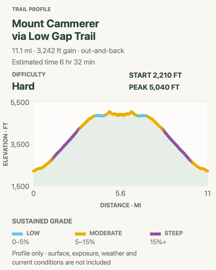
| Mount Cammerer via Low Gap Trail | 11.2 mi | 6 hr 32 min | Hard | A hard summit day to the park's stone fire lookout |
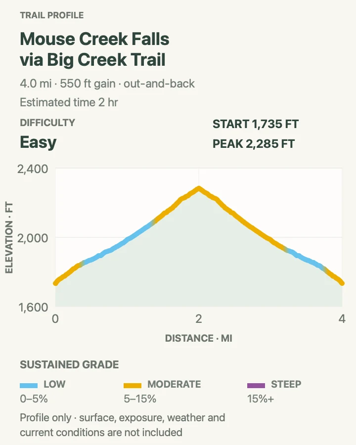
| Mouse Creek Falls via Big Creek Trail | 4 mi | 2 hr | Easy | An easy-grade creek walk to a photogenic cascade |
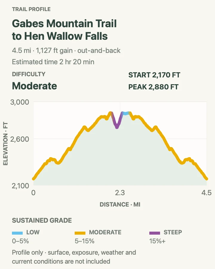
| Gabes Mountain Trail to Hen Wallow Falls | 4.6 mi | 2 hr 20 min | Moderate | A shaded Cosby waterfall hike |
| Hemphill Bald via Cataloochee Divide Trail | 8.7 mi | 4 hr 28 min | Moderate | A quiet ridgeline and pastoral bald above Cataloochee |
Mount Cammerer via Low Gap Trail
- Distance
- 11.2 mi
- Elevation gain
- 3,242 feet
- Time
- 6 hr 32 min
- Difficulty
- Hard
- Route type
- Out And Back
- Parking
- Cosby Campground area at the Low Gap trailhead
- Best time
- A clear, cool day with long daylight
- Pets
- Not allowed
Low Gap Trail climbs steeply from Cosby to the Appalachian Trail, then follows the ridge to a final spur and Mount Cammerer's octagonal stone lookout. Most of the elevation comes early; the descent on the same grade is punishing on tired legs.
The payoff is unusually open for the Smokies. Rock around the tower looks across the Pigeon River gorge and the northeastern mountains, making this a route worth saving for a clear forecast rather than merely an open day on the calendar.
Carry enough water and food for a long outing, plus a headlamp and a layer for the exposed summit. The lookout is a historic structure, so pack out everything and avoid crowding its edges. If cloud has settled on the ridge, Hen Wallow Falls is the more sensible Cosby choice.

Mouse Creek Falls via Big Creek Trail
- Distance
- 4 mi
- Elevation gain
- 550 feet
- Time
- 2 hr
- Difficulty
- Easy
- Route type
- Out And Back
- Parking
- Big Creek trailhead; verify the access road after storms
- Best time
- Morning in spring, summer, or fall
- Pets
- Not allowed
Big Creek Trail follows a former railroad grade beside clear, fast water to Mouse Creek Falls, which enters from the opposite bank in a graceful cascade. Midnight Hole provides another stop along the way, and the broad tread keeps the walking easier than most four-mile waterfall outings in the park. The water is not equally forgiving: pools are cold, current can be strong, and jumping from rocks is dangerous. Keep children close, carry the map offline, and verify Big Creek road access after storms before making the drive.

Gabes Mountain Trail to Hen Wallow Falls
- Distance
- 4.6 mi
- Elevation gain
- 1,127 feet
- Time
- 2 hr 20 min
- Difficulty
- Moderate
- Route type
- Out And Back
- Parking
- Cosby Picnic Area or campground trail parking, following seasonal signs
- Best time
- Spring wildflowers or after moderate rainfall
- Pets
- Not allowed
Gabes Mountain Trail rolls through rich hardwood forest before descending a short, steep side trail to Hen Wallow Falls. The tall cascade spreads into a fan over dark rock, while the approach offers spring wildflowers and a quieter atmosphere than the waterfalls near Gatlinburg. The return includes enough climbing to keep the moderate rating honest.
The side trail to the base is narrow and can be slippery, so save it for stable footing and give uphill hikers room. Water flow varies with recent rain, but high water is not a reason to move closer to the cascade. This is the best backup on the northeastern side when cloud makes Mount Cammerer unrewarding or a group wants a shorter day.

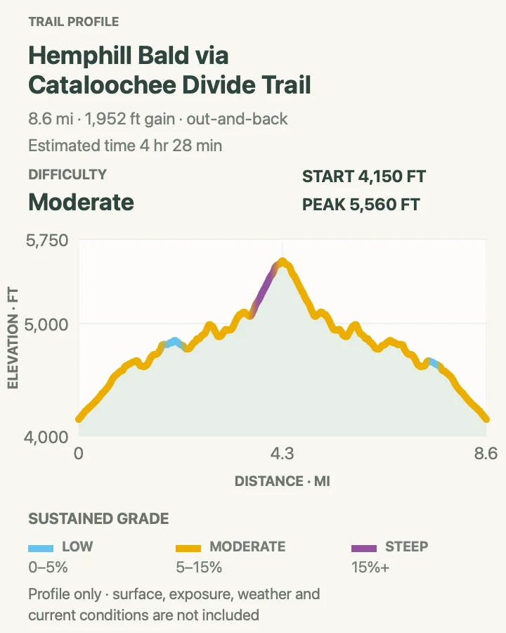
Hemphill Bald via Cataloochee Divide Trail
- Distance
- 8.7 mi
- Elevation gain
- 1,952 feet
- Time
- 4 hr 28 min
- Difficulty
- Moderate
- Route type
- Out And Back
- Parking
- Cataloochee Divide trail access near Purchase Knob; confirm the legal approach and seasonal road status
- Best time
- A clear spring or fall day
- Pets
- Not allowed
Hemphill Bald follows the Cataloochee Divide through rolling high forest to a broad grassy opening with layered views toward the valley and distant ridges. The route is longer and less famous than the park's central summits, which is precisely its appeal: sustained ridge walking, historic landscape, and room to hear wind and birds instead of traffic.
Access is the important variable. Roads and trails around Cataloochee have experienced storm damage, and navigation from the trailhead is less obvious than at a major visitor center. Confirm the official route and current closures before leaving, carry the map offline, and do not use private drives as shortcuts. Elk and other wildlife need generous space, especially near open fields.

Cherokee, Smokemont, and Deep Creek
North Carolina's southern side supplies the guide's easiest riverside walk, a compact waterfall loop, a historic creek route, and a steep overlook climb. These trails work well for Cherokee or Bryson City bases and provide alternatives when Newfound Gap Road is busy.
| Trail | Distance | Time | Difficulty | Best for |
|---|---|---|---|---|
| Deep Creek Waterfall Loop | 2.5 mi | 1.5 to 2.5 hours | Moderate | Three waterfalls in one compact Bryson City loop |
| Oconaluftee River Trail | 3.2 mi | 1 hr 30 min | Easy | An easy, dog-friendly river walk from the visitor center |
| Kephart Shelter via Kephart Prong Trail | 4 mi | 2 hr 30 min | Moderate | Creek crossings, CCC history, and a backcountry shelter |
| Lonesome Pine Overlook | 7 mi | 5 hr | Hard | A steep, quieter overlook climb from Deep Creek |
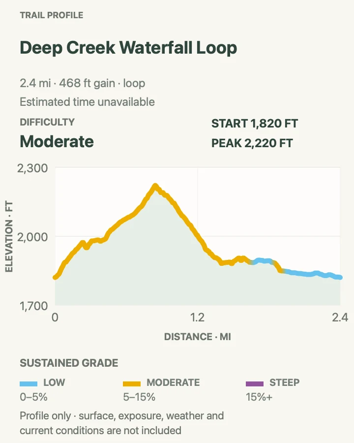
Deep Creek Waterfall Loop
- Distance
- 2.5 mi
- Elevation gain
- 468 feet
- Time
- 1.5 to 2.5 hours
- Difficulty
- Moderate
- Route type
- Loop
- Parking
- Deep Creek trailhead parking north of Bryson City
- Best time
- Morning before summer tubing traffic builds
- Pets
- Not allowed
Deep Creek's waterfall loop connects Tom Branch Falls, Indian Creek Falls, and Juney Whank Falls using a mix of broad creekside grade and steeper forest trail. Tom Branch is visible from the main path; bridges, stairs, and the climb toward Juney Whank make the full circuit feel like a hike rather than a roadside tour. Summer tubing crowds the opening corridor, so an early start is quieter. Follow the signed junctions—the surrounding trails continue much farther into the backcountry—and use established waterfall viewpoints because rocks and wooden steps remain slick in shade.

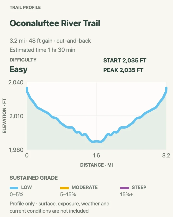
Oconaluftee River Trail
- Distance
- 3.2 mi
- Elevation gain
- 48 feet
- Time
- 1 hr 30 min
- Difficulty
- Easy
- Route type
- Out And Back
- Parking
- Oconaluftee Visitor Center or legal access in Cherokee, depending on the chosen turnaround
- Best time
- Morning or evening, especially in spring and fall
- Pets
- Allowed on a leash no longer than 6 feet
Oconaluftee River Trail follows the river between the visitor center and Cherokee on a wide, gently rolling path that can be shortened at any point. Spring wildflowers, river views, and the Mountain Farm Museum make it a useful first or last walk in the park. It is also one of only two park trails where leashed pets are allowed. Keep dogs close and yield to other visitors. Elk often use the fields near the visitor center, so give them a very wide berth, obey temporary field closures, and never approach for a photograph.

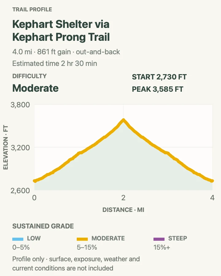
Kephart Shelter via Kephart Prong Trail
- Distance
- 4 mi
- Elevation gain
- 861 feet
- Time
- 2 hr 30 min
- Difficulty
- Moderate
- Route type
- Out And Back
- Parking
- Kephart Prong roadside pullout on Newfound Gap Road; use only marked spaces
- Best time
- A dry morning in spring through fall
- Pets
- Not allowed
Kephart Prong Trail follows a lively creek over several footbridges, passing Civilian Conservation Corps camp remains on the way to Kephart Shelter. The steady grade makes it an excellent middle-distance forest hike. Stone chimneys and old foundations mark the former camp; beyond them, the footbridges and creek remain the main attraction.
The shelter is part of the park's backcountry system, not a guaranteed lunch room for day hikers. Respect campers and do not leave food or gear. Bridges and stream banks can be slick after rain, and the Newfound Gap Road pullout fills quickly. If the space is full, continue to a legal alternative instead of walking along the highway shoulder.

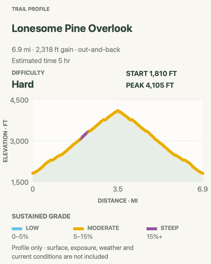
Lonesome Pine Overlook
- Distance
- 7 mi
- Elevation gain
- 2,318 feet
- Time
- 5 hr
- Difficulty
- Hard
- Route type
- Out And Back
- Parking
- Deep Creek trailhead parking near Bryson City
- Best time
- A cool, clear day outside the busiest summer weekends
- Pets
- Not allowed
Lonesome Pine Overlook climbs from Deep Creek on the Noland Divide route, trading the busy waterfall corridor for a long, steady ascent. The overlook opens toward Bryson City, Fontana Lake country, and the southern ridges. It is a satisfying choice for hikers who want a hard viewpoint day without driving to the park's central high-country lots.
The climb is sustained and the lower forest can be hot and humid. Start early, carry more water than the shaded trail suggests, and save energy for the descent. Junctions above Deep Creek connect to much longer routes, so keep the map available. If the viewpoint is socked in, the waterfall loop is the better use of the day.

How these hikes were chosen
Routes are grouped by approach road rather than numbered from best to worst. The selection balances mountain views, waterfalls, history, easy walks, full-day challenges, quieter alternatives, and terrain found only in particular corners of the Smokies. A heavily reviewed trail was still left out when it merely repeated a stronger option in the same region.
The maps and elevation profiles come from the National Parks Guide trail library and use audited route geometry. Elevation gain is calculated from the mapped route. Before hiking, compare this guide with the NPS hiking safety guidance, current conditions, and signs at the trailhead.