7 Best Hikes in Badlands National Park
Seven Badlands hikes, from the Door and Notch to long prairie routes, with terrain maps, elevation profiles, parking notes, and current park alerts.
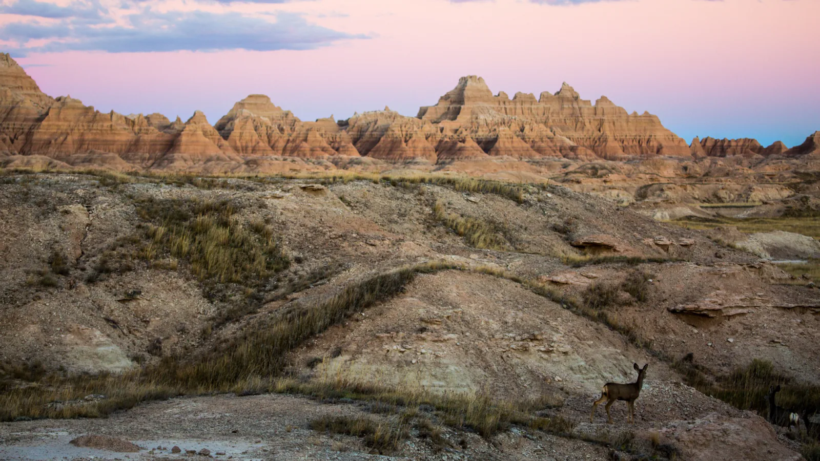
Badlands hiking comes in two forms. Near Cedar Pass, signed paths and boardwalks lead into fins, gullies, and the Badlands Wall. West of the paved loop road, the experience changes to open prairie and backcountry route-finding. These seven outings cover both sides of the park without counting every overlook as a separate hike.
The list is arranged from shorter established trails to longer and less structured days. Door, Notch, Castle, Medicine Root, and Saddle Pass form the useful core. Deer Haven and Sage Creek are here for hikers who understand that a line on a map does not turn open country into a maintained trail.
Mileage beside each profile follows the reviewed route line used for that graphic. National Park Service signs sometimes use a shorter boardwalk-only distance or round to a different tenth. Check the trailhead sign before starting, especially where an established path continues into open formations.
What changes a hiking day here
Clay turns slick after rain
Dry badlands clay can feel firm and grippy. Rain changes it quickly, and a steep slope that was easy on the way up can become awkward on the descent. Notch and Saddle Pass deserve a different plan when storms have passed through. Dry washes can also take runoff from rain that falls out of sight.
Heat and water set the pace
Summer afternoons regularly climb past 100 degrees Fahrenheit. The park recommends two quarts of water per person for a two-hour hike, plus sun protection and sturdy closed-toe footwear. There is almost no reliable shade on Castle, Medicine Root, or the western backcountry routes.
Wildlife needs a wide berth
Keep at least 100 feet from wildlife. Bison can move much faster than a hiker, and prairie rattlesnakes may shelter near steps, boardwalks, tall grass, or rock edges. Back away if an animal changes its behavior because of you.
Cell service is a poor backup
Coverage is unreliable away from developed areas. Save the park map before the drive, carry a paper map or offline topographic map for backcountry travel, and tell someone where you are going. Deer Haven and Sage Creek require sound navigation even when the day begins with a clear view.
| Trail | Distance | Time | Difficulty | Best for |
|---|---|---|---|---|
| Door Trail | 0.8 mile for the mapped boardwalk and post-marked extension | 30 to 45 minutes | Easy to the boardwalk; uneven beyond it | A first walk into the formations |
| Notch Trail | 1.25 miles round trip | 1.5 to 2 hours | Moderate to strenuous | The ladder, ledges, and White River Valley view |
| Castle Trail | 10.2 miles round trip | About 5 hours | Moderate | A long day among formations and prairie |
| Medicine Root and Castle Trail Loop | 4 miles | About 2 hours | Moderate | Prairie walking with distant Wall views |
| Saddle Pass Trail | 0.68 mile round trip | About 40 minutes | Strenuous | A short, steep climb to the Wall |
| Deer Haven Backcountry Route | About 5 miles round trip on the mapped route | 3 to 5 hours | Strenuous backcountry travel | Backcountry solitude and juniper country |
| Sage Creek Wilderness Route | 1.9 miles round trip on the mapped route | 1.5 to 2.5 hours | Moderate backcountry travel | Open prairie and a first taste of the western backcountry |
Door Trail
- Distance
- 0.8 mile for the mapped boardwalk and post-marked extension
- Elevation gain
- 25 feet
- Time
- 30 to 45 minutes
- Difficulty
- Easy to the boardwalk; uneven beyond it
- Route type
- Out and back
- Parking
- Use the large Door, Window, and Notch parking area on Badlands Loop Road.
- Best time
- Early morning, when the formations hold side light and the boardwalk is cooler.
- Pets
- Pets are not allowed on park trails. Trained service animals are allowed.
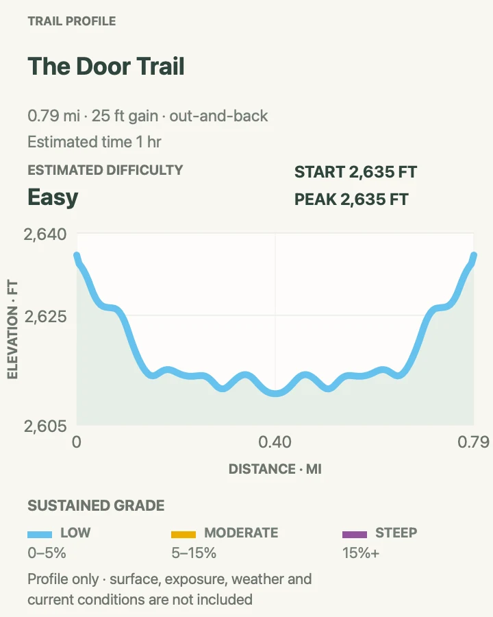
Door Trail begins on an accessible boardwalk and passes through a break in the Badlands Wall. The official boardwalk portion is about a quarter mile round trip. At its end, yellow posts continue across exposed clay and small gullies, which accounts for the longer route shown on this page.
The boardwalk gives a good view with almost no route-finding. Beyond it, the surface becomes rough and the posts can disappear behind folds in the terrain. Turn around at the boardwalk if heat, mud, mobility, or visibility makes the extension a poor choice. The return view toward the Wall is worth looking back for.
What helps on this route
- Photograph the number of the nearest post if you wander a short distance from the line.
- Use the restroom at the parking area before starting; facilities are sparse along the loop road.
Terrain and access: Accessible boardwalk to the overlook, followed by exposed, uneven clay and short gullies on the optional extension.

Notch Trail
- Distance
- 1.25 miles round trip
- Elevation gain
- 120 feet
- Time
- 1.5 to 2 hours
- Difficulty
- Moderate to strenuous
- Route type
- Out and back
- Parking
- Start at the north end of the Door, Window, and Notch parking area.
- Best time
- A dry morning before heat or thunderstorms build.
- Pets
- Pets are not allowed on park trails. Trained service animals are allowed.
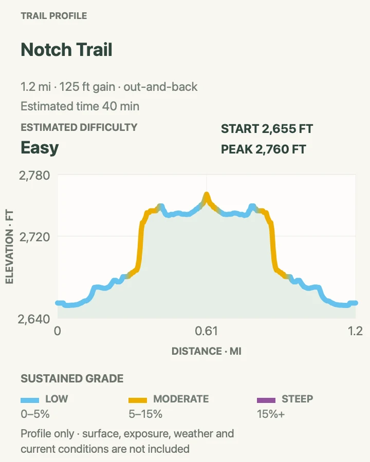
Notch Trail enters a narrow wash, reaches a steep log ladder, then traverses a ledge above the canyon floor. The finish opens suddenly at the Notch, where the White River Valley spreads below the Badlands Wall. The route earns its reputation through exposure and loose footing rather than mileage.
The ladder is the pinch point. Hikers move in both directions, so wait where there is room instead of passing on the rungs. The ledge after the ladder has drop-offs and gravel underfoot. Anyone uneasy with heights will have a better day on Castle or Medicine Root. Rain makes the clay and descent much harder.
What helps on this route
- Keep both hands free for the ladder and pack loose items before climbing.
- Let uphill traffic clear the narrow sections before beginning the descent.
Terrain and access: Canyon floor, a steep log ladder, exposed ledges, loose gravel, and unshaded clay.

Castle Trail
- Distance
- 10.2 miles round trip
- Elevation gain
- 200 feet
- Time
- About 5 hours
- Difficulty
- Moderate
- Route type
- Out and back, with shorter turnaround options
- Parking
- Begin at the Door and Window area or the Fossil Exhibit parking area; the trail links the two.
- Best time
- Cool, dry weather with an early start and a stable forecast.
- Pets
- Pets are not allowed on park trails. Trained service animals are allowed.
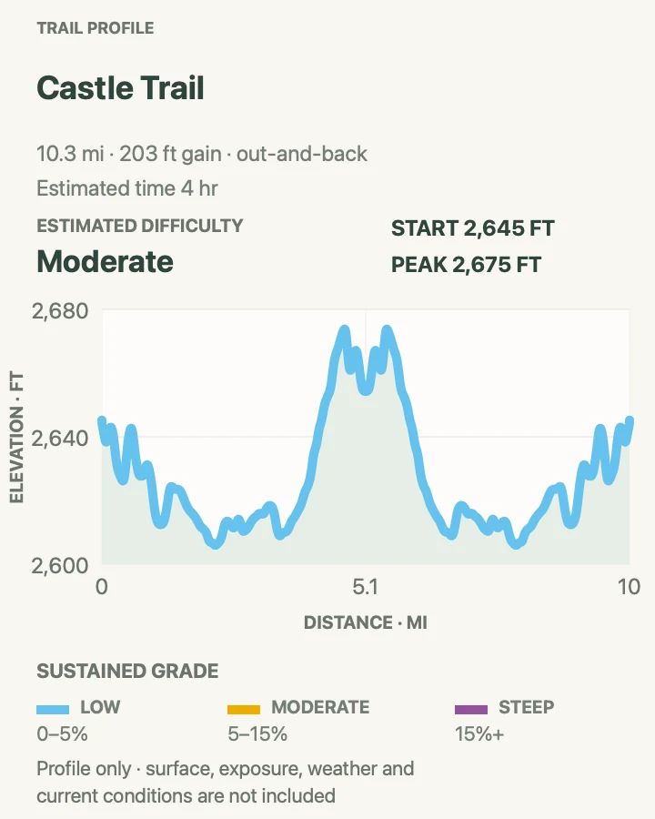
Castle is the park's longest established trail. It runs between the Door and Window area and Fossil Exhibit Trail, staying comparatively level while moving along the base of the formations. The distance brings more solitude than the short Cedar Pass trails, even though both ends begin beside busy parking areas.
An out-and-back from either trailhead is simple to shorten. A two-car arrangement can make it a one-way walk, but the shuttle must be set before starting. There is little shade and no water on the trail. Medicine Root and Saddle Pass junctions create loop possibilities, so check every sign rather than following the most worn track.
What helps on this route
- Carry the water for the entire walk; the open prairie offers no refill point.
- Mark the chosen parking area on an offline map before using any connector trail.
Terrain and access: Rolling prairie and badlands clay with long exposed stretches, modest grades, and several signed junctions.

Medicine Root and Castle Trail Loop
- Distance
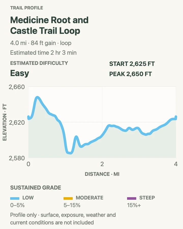
- 4 miles
- Elevation gain
- 85 feet
- Time
- About 2 hours
- Difficulty
- Moderate
- Route type
- Loop
- Parking
- Use the Old Northeast Road pull-off or reach the loop from Castle or Saddle Pass.
- Best time
- Morning in spring or fall, when the mixed-grass prairie is comfortable to cross.
- Pets
- Pets are not allowed on park trails. Trained service animals are allowed.
Medicine Root leaves the close formations for mixed-grass prairie. Long views make the route feel open, and the Badlands Wall stays on the horizon rather than crowding the trail. Joining it with part of Castle creates a tidy loop that has less exposure than Notch and less climbing than Saddle Pass.
The easy-looking ground can hide cactus, holes, and rattlesnakes in grass. Watch the tread and give bison a large detour. The route can be extended toward Saddle Pass or trimmed by turning back at a junction. In wet weather, prairie soil can cling to boots and the Castle segment becomes slick.
What helps on this route
- Use long pants and closed-toe shoes for cactus and tall grass.
- Do not squeeze past bison on the trail; turn around or make a very wide detour where travel is allowed.
Terrain and access: Rolling mixed-grass prairie, badlands clay, cactus, and exposed junctions with little shade.

Saddle Pass Trail
- Distance
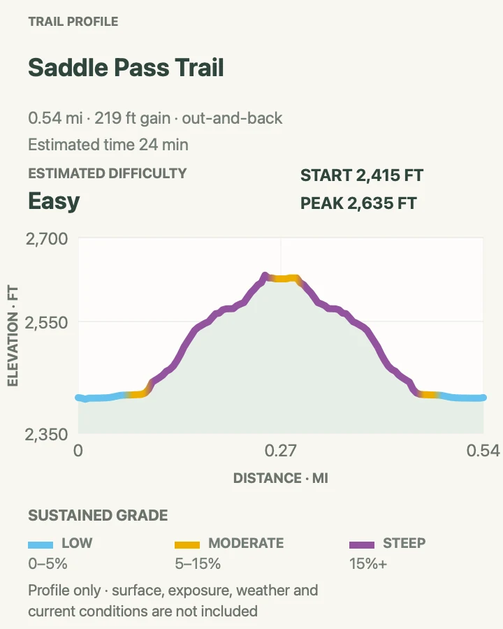
- 0.68 mile round trip
- Elevation gain
- 220 feet
- Time
- About 40 minutes
- Difficulty
- Strenuous
- Route type
- Out and back
- Parking
- Use the signed Saddle Pass pull-off on Badlands Loop Road.
- Best time
- A dry, cool morning; skip it during extreme heat or after rain.
- Pets
- Pets are not allowed on park trails. Trained service animals are allowed.
Saddle Pass goes straight at the Badlands Wall. The climb is brief and much steeper than the mileage suggests, ending at a broad view over the White River Valley and junctions with Castle and Medicine Root. It is a useful standalone climb or an energetic entrance to the longer trail network.
Loose soil makes the descent harder than the ascent. Face into the slope where needed and leave space between hikers so dislodged stones do not hit someone below. The route is a bad choice when the clay is wet. At the top, note the descent point before walking away toward Castle or Medicine Root.
What helps on this route
- Stow trekking poles if they interfere with using your hands on the steepest section.
- Look back from the top and identify the descent line before exploring the junction.
Terrain and access: Very steep badlands clay with loose gravel, little shade, and a slippery descent after rain.

Deer Haven Backcountry Route
- Distance
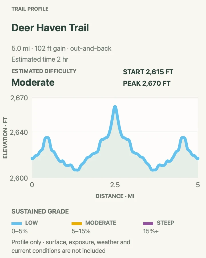
- About 5 miles round trip on the mapped route
- Elevation gain
- 100 feet
- Time
- 3 to 5 hours
- Difficulty
- Strenuous backcountry travel
- Route type
- Out and back
- Parking
- Confirm the current access point and road condition with a ranger before leaving the developed corridor.
- Best time
- A cool, dry day with enough daylight for slower route-finding.
- Pets
- Pets are not allowed on park trails. Trained service animals are allowed.
Deer Haven is a backcountry destination rather than a maintained park trail. The route climbs toward a grove of junipers tucked into the buttes, a place the park also identifies as a possible backcountry camping area. Expect animal paths, open ground, and several plausible lines instead of frequent trail markers.
The map records one reviewed approach, not a promise of signs on the ground. Carry a topographic map and compass or GPS, track the return direction, and speak with a ranger about access before setting out. Clay slopes, gullies, and grass can erase a faint path. This is not the place to learn navigation for the first time.
What helps on this route
- Save a waypoint at the vehicle and check that it recorded before walking away.
- Carry more time and water than the measured mileage would require on a signed trail.
Terrain and access: Unmaintained prairie and badlands backcountry with faint paths, gullies, clay slopes, and active wildlife.

Sage Creek Wilderness Route
- Distance
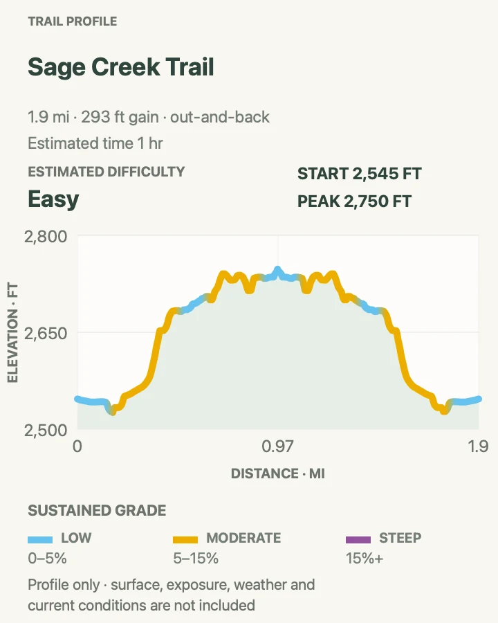
- 1.9 miles round trip on the mapped route
- Elevation gain
- 290 feet
- Time
- 1.5 to 2.5 hours
- Difficulty
- Moderate backcountry travel
- Route type
- Out and back
- Parking
- Use a legal pull-off near the Sage Creek area only after checking the gravel-road condition.
- Best time
- Morning or evening in dry weather, with extra time for wildlife delays.
- Pets
- Pets are not allowed on park trails. Trained service animals are allowed.
Sage Creek country is broad, grassy, and lightly developed. This short mapped outing leaves the road corridor for open prairie rather than following a maintained, signed trail. Bison, prairie dogs, and distant buttes often matter more to the walk than a fixed destination.
Treat the route line as planning context. Animal paths split, grass hides holes, and bison may occupy the most convenient line. Keep at least 100 feet away and turn back if a safe detour is not obvious. Sage Creek Rim Road is gravel and can become slick, rutted, or temporarily unsuitable after weather.
What helps on this route
- Choose a visible return landmark before leaving the road and confirm it from several angles.
- Do not approach bison for a photograph; their presence can change the route or end the hike.
Terrain and access: Unmarked mixed-grass prairie with animal paths, holes, cactus, little shade, and possible bison encounters.

Official planning sources
Trail access and safety details were checked against these National Park Service pages. The maps and profiles use the reviewed route geometry stored with this guide.
Map data © OpenStreetMap contributors. Trail geometry and planning details include National Park Service public information.