7 Best Hikes in Mammoth Cave National Park
Seven Mammoth Cave surface hikes, from short spring and sinkhole walks to full backcountry days, with reviewed maps and profiles.
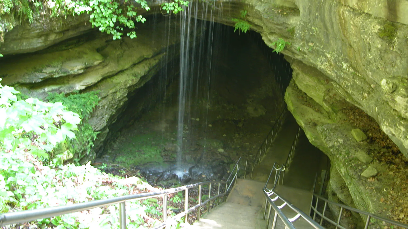
Mammoth Cave's trail system is split by the Green River. South of the river, short paths begin near paved roads and the visitor center. North of it, more than 60 miles of backcountry trail cross wooded ridges, creek hollows, old home sites, and cemeteries. That division makes it possible to fit a ten-minute pond walk between cave tours or spend most of a day far from the main complex.
These seven hikes are grouped by the day they suit, not by an app's ranking. Echo River Springs, Sloan's Crossing Pond, Cedar Sink, and Turnhole Bend are concise walks with distinct subjects. Big Hollow is the cleanest long loop. Wet Prong and Mammoth Creek–First Creek are quiet backcountry commitments where navigation and trail conditions matter more than the modest elevations suggest.
A live planning note matters here. As of August 29, 2026, NPS lists the Old Guides Trail, Heritage Trail, Sunset Point Trail, and parts of the Sinkhole Trail as closed for rehabilitation. Those closures break several familiar visitor-center loops, so none is presented below as a current route. Check conditions again on the morning of the hike because ferry and road status can change without notice.
What changes a hiking day here
Keep cave tickets and surface mileage separate
Cave tours have fixed departure times, and NPS asks visitors to arrive about 30 minutes early. Reserve a tour before building a hiking day around it. A long north-side walk should not be squeezed into the hours before a paid tour.
Confirm the Green River crossing
The Green River Ferry is the park's only vehicle crossing between the developed south side and much of the north-side trail network. Call the ferry hotline or review current conditions before driving to Big Hollow, Wet Prong, or First Creek. A closure can require a much longer approach from outside the park.
Treat humidity and ticks as part of the route
Summer temperatures can exceed 90°F, and Kentucky humidity slows the pace. Carry water, use tick protection, and check clothing, children, and pets after the hike. Poison ivy and venomous snakes also occur along the surface trails.
Leashed pets can use surface trails
Pets may use all surface trails on a leash no longer than six feet, but they cannot enter caves or park buildings. Backcountry users may meet horses, and Big Hollow also carries mountain bikes. Step off at a safe place and keep the leash short while other users pass.
| Trail | Distance | Time | Difficulty | Best for |
|---|---|---|---|---|
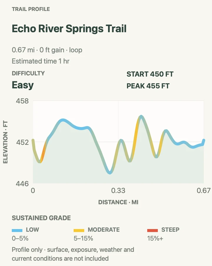
| Echo River Springs Loop | About 0.7-mile loop | 1 hr | Easy | An accessible cave-spring walk beside the Green River |
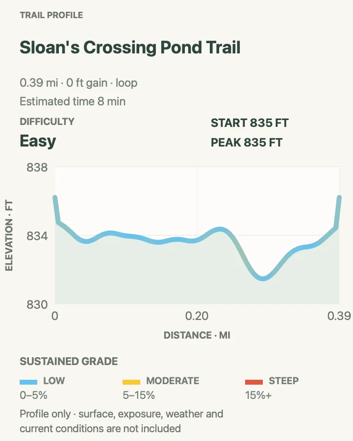
| Sloan's Crossing Pond Walk | About 0.4-mile loop | 8 min | Easy | An easy wildlife stop and an accessible family walk |
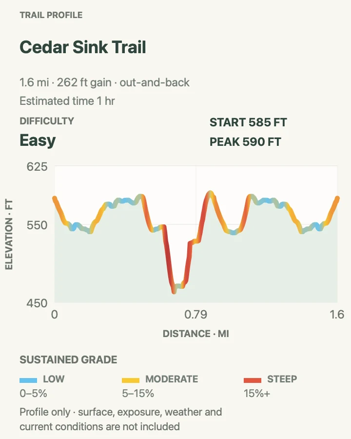
| Cedar Sink Trail | About 1.6 miles for the mapped approach and sink circuit | 1 hr | Easy | Seeing a giant karst collapse from inside its forested basin |
| Turnhole Bend Nature Trail | About 0.5-mile loop | 1 hr | Moderate | A short forest walk above a dramatic Green River bend |
| Big Hollow North and South Loops | About 11.1-mile circuit from the mapped trailhead | 4 hr 30 min | Moderate | A long rolling woodland loop without a road shuttle |
| Wet Prong Trail | About 9.1 miles out and back | 4 hr | Moderate | A quiet creek-hollow day with few developed features |
| Mammoth Creek–First Creek Trail | About 12.7 miles out and back | 6 hr | Hard | The longest backcountry day in this guide |
Echo River Springs Loop
- Distance
- About 0.7-mile loop
- Elevation gain
- 0 feet
- Time
- 1 hr
- Difficulty
- Easy
- Route type
- loop
- Parking
- Start at the Echo River Springs trailhead near Green River Ferry; use the designated lot rather than the ferry queue.
- Best time
- Morning or late afternoon when the spring and riverbank are quiet.
- Pets
- Leashed pets are allowed on the surface trail.
This low loop follows the place where cold groundwater leaves the cave system and joins the surface drainage. The spring-fed channel, pedestrian bridge, and Green River edge make it one of the shortest walks in the park that still explains how the cave works beyond its toured passages.
NPS identifies this as an accessible trail, although flooding, leaf litter, or maintenance can change the usable surface. Do not extend the walk into the currently closed Sinkhole, Heritage, or Sunset Point segments. The map here covers the signed short loop from the river-side trailhead.
What helps on this route
- Check ferry-area road status before driving down the hill.
- Bring binoculars for the riverbank rather than approaching wildlife near the water.
Terrain and access: Short paved and firm-surface loop, bridge, low grade, cave-fed channel, riverbank exposure, and possible wet or flooded patches.

Sloan's Crossing Pond Walk
- Distance
- About 0.4-mile loop
- Elevation gain
- 0 feet
- Time
- 8 min
- Difficulty
- Easy
- Route type
- loop
- Parking
- Use the signed pond and picnic-area lot on Mammoth Cave Parkway.
- Best time
- Early morning for frogs, turtles, marsh birds, and fewer passing cars.
- Pets
- Leashed pets are allowed; keep them away from pond wildlife.
A rehabilitated boardwalk circles one of the park's uncommon surface ponds. Karst terrain drains most water underground, so this marshy pocket supports a different set of plants and animals from the surrounding dry forest. Turtles bask on logs, frogs work the shallows, and red-winged blackbirds use the reeds.
The whole circuit is short enough to pair with a cave tour or picnic. NPS describes the boardwalk and overlooks as wheelchair accessible, but rain, debris, or repairs can affect a particular day. Stay on the decking and leave logs, turtles, and wetland plants alone.
What helps on this route
- Walk slowly and listen before scanning the reeds; movement is easier to notice after the group settles.
- Do not feed waterfowl or leave picnic scraps near the pond.
Terrain and access: Accessible boardwalk and firm approaches, negligible climbing, pond overlooks, marsh edge, shade, and occasional slick leaves.

Cedar Sink Trail
- Distance
- About 1.6 miles for the mapped approach and sink circuit
- Elevation gain
- 260 feet
- Time
- 1 hr
- Difficulty
- Easy
- Route type
- out-and-back
- Parking
- Use the Cedar Sink trailhead lot, roughly ten minutes from the visitor center.
- Best time
- A cool spring morning for wildflowers, or after dry weather for better footing.
- Pets
- Leashed pets are allowed, but the stairs make this a poor choice for some dogs.
The route begins on a broad woodland path, then drops into an enormous sink where surface water disappears into the cave system. NPS counts 295 stairs across the official one-mile trail. The mapped approach used here reaches about 1.6 miles and shows the full out-and-back travel plus the lower circuit, so allow more time than the shortest park description implies.
Spring and early summer bring the best flower display. The same enclosed bowl can trap heat and humidity later in the day. Inside the sink, resist stepping off the path for plants or openings; loose slopes and karst voids are poor places to improvise a route.
What helps on this route
- Save energy for the stair climb out; the low point arrives near the middle, not the end.
- The small lot fills on busy weekends, so use an early start.
Terrain and access: Rolling dirt approach, long stair sequences, steep sink walls, short flat basin, roots, humid shade, and about 260 feet of accumulated gain on the mapped route.

Turnhole Bend Nature Trail
- Distance
- About 0.5-mile loop
- Elevation gain
- 110 feet
- Time
- 1 hr
- Difficulty
- Moderate
- Route type
- loop
- Parking
- Park at the signed Turnhole Bend trailhead on Brownsville Road.
- Best time
- Late fall through spring, or early on a humid summer day.
- Pets
- Leashed pets are allowed on the trail.
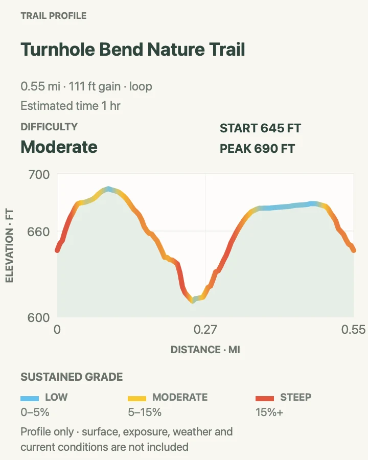
Turnhole Bend packs river geology into a half-mile loop. A wooded path reaches views over a tight Green River curve near Turnhole Spring, where water moving underground through the cave system returns to the surface. The overlook feels removed from the road despite the short distance.
The riverbank and bluff are not a place to hunt for an unofficial shortcut. Stay behind barriers and on the maintained path, especially when leaves hide the edge. High water can change both the sound and appearance of the bend without making a closer viewpoint safe.
What helps on this route
- Autumn leaves open the view but can hide roots and slick rock.
- Pair this with Cedar Sink; the two trailheads are on the same side of the park.
Terrain and access: Short woodland loop, roots, bluff edge, mild climbing, leaf cover, river overlook, and no dependable water source.

Big Hollow North and South Loops
- Distance
- About 11.1-mile circuit from the mapped trailhead
- Elevation gain
- 610 feet
- Time
- 4 hr 30 min
- Difficulty
- Moderate
- Route type
- loop
- Parking
- Use the Big Hollow or Maple Springs trailhead area north of the Green River; confirm ferry access first.
- Best time
- A dry cool-season day, starting early enough to finish before dark.
- Pets
- Leashed pets are allowed; expect mountain bikes on this trail.
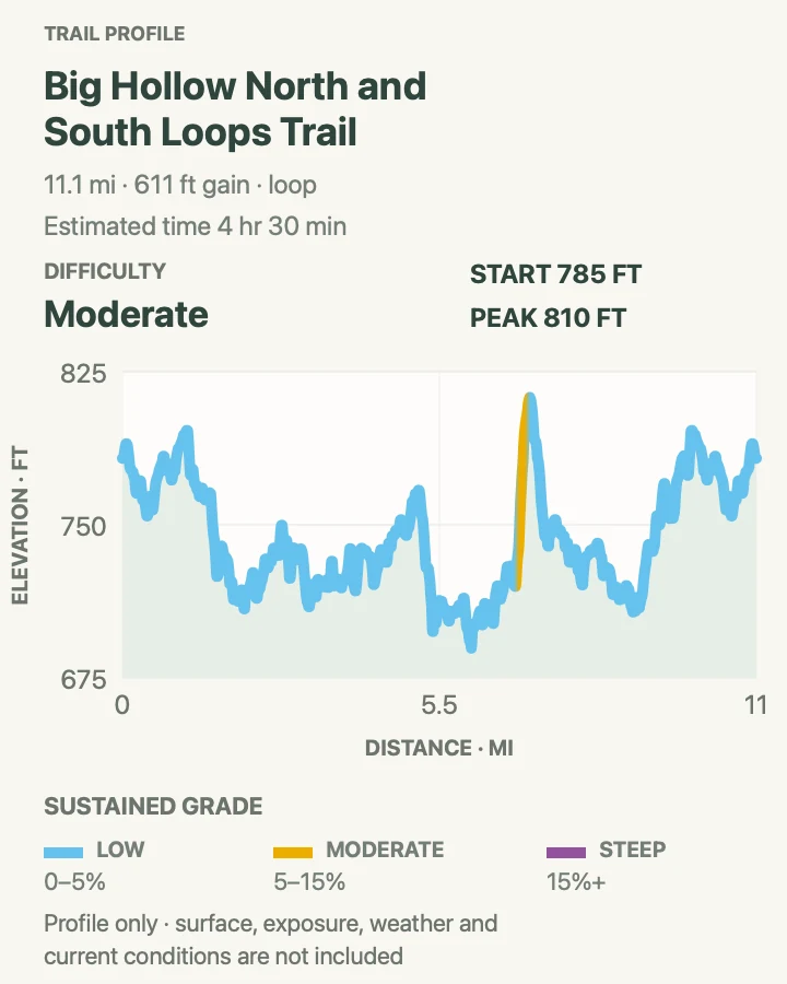
Big Hollow combines the 5.3-mile North Loop and 3.7-mile South Loop with the trailhead connectors shown on the map. Its single-track path runs through dense forest and rocky outcrops, accumulating distance through repeated small rises rather than one summit climb.
This is the only north-side trail system NPS specifically promotes for mountain biking, so hikers should listen at bends and yield where the tread narrows. Trail leaves can cover rock, and the modest profile can disguise how tiring eleven humid miles become. Carry the backcountry map even though the route returns to its start.
What helps on this route
- Choose one loop if the full mapped circuit is longer than the group wants.
- Wear bright clothing during seasons when park hunting rules permit activity nearby.
Terrain and access: Wooded single-track, repeated low ridges, rocky outcrops, bike traffic, many bends, leaf cover, and roughly eleven miles of rolling travel.

Wet Prong Trail
- Distance
- About 9.1 miles out and back
- Elevation gain
- 860 feet
- Time
- 4 hr
- Difficulty
- Moderate
- Route type
- out-and-back
- Parking
- Begin at First Creek trailhead for the mapped out-and-back; verify the correct junction before leaving the lot.
- Best time
- Dry fall or spring weather, after checking river access and recent rain.
- Pets
- Leashed pets are allowed; horses may use connected backcountry trails.
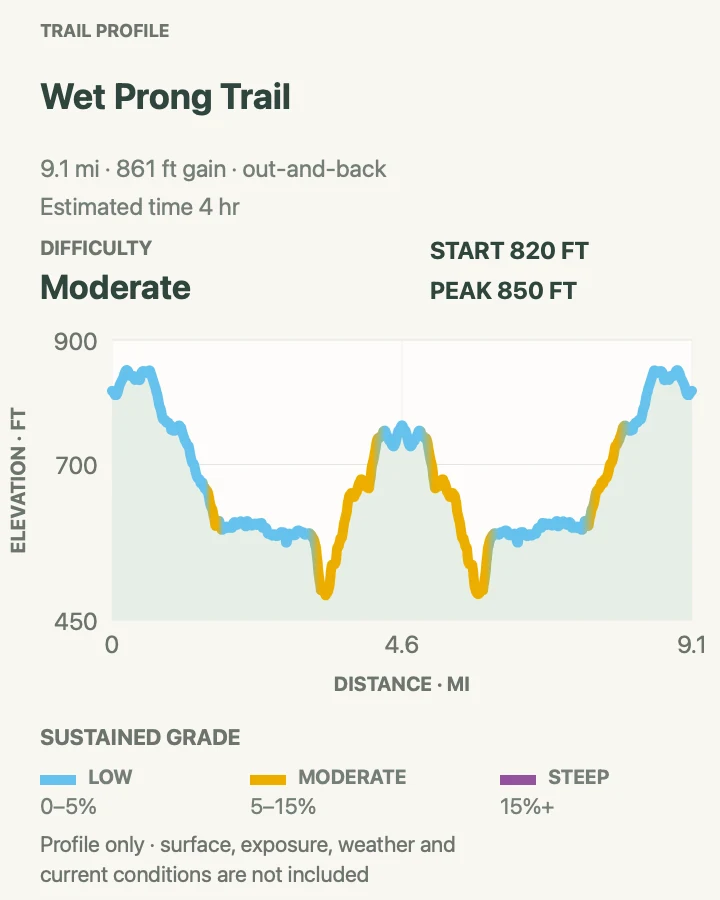
Wet Prong follows a subdued north-side hollow between First Creek and the Collie Ridge junction. NPS lists the trail at 4.6 miles from end to end; returning to the same vehicle produces the 9.1-mile day shown by the profile. Much of the walk feels gentle, but mud and repeated drainage crossings can set the pace.
There are no visitor-center services here and trail signs are less frequent than on the south side. Carry a paper backcountry map, water treatment for emergencies, and enough food to reverse course if a crossing or fallen tree ends the day. Do not assume a wet-weather creek is a safe drinking source.
What helps on this route
- Turn around at the halfway time even if the mapped endpoint has not been reached.
- After heavy rain, choose a south-side path rather than forcing muddy crossings.
Terrain and access: Long wooded hollow, mud, creek crossings, roots, horse use on connected trails, modest ridge changes, and about nine miles of remote travel.

Mammoth Creek–First Creek Trail
- Distance
- About 12.7 miles out and back
- Elevation gain
- 1,800 feet
- Time
- 6 hr
- Difficulty
- Hard
- Route type
- out-and-back
- Parking
- Use the First Creek day-use and backcountry parking area on Ollie Road.
- Best time
- A dry cool-season day with an early start and a stable forecast.
- Pets
- Leashed pets are allowed; plan water for them and yield to horses.
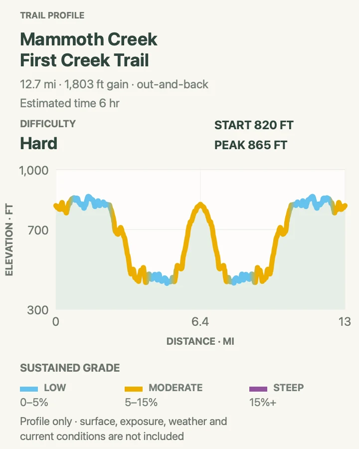
This route reaches deep into the north-side trail network from First Creek. It follows creek bottoms and wooded ridges with old roads, junctions, and backcountry campsite spurs nearby. The profile stays low by mountain standards, yet twelve-plus miles of roots, mud, and route finding make it a serious day.
A phone track is a supplement here, not the navigation plan. Download the official backcountry map, carry a paper copy, and note every junction on the outbound leg. Overnight use requires a backcountry permit; this description assumes a day hike returning to the same trailhead.
What helps on this route
- Leave the route and expected return time with someone outside the park.
- If the ferry is closed, recalculate the drive before committing to the trailhead.
Terrain and access: Remote creek bottoms, wooded ridges, roots, mud, unsigned-looking junctions, horse use, little cell service, and a long return to the trailhead.

Official planning sources
Trail access and safety details were checked against these National Park Service pages. The maps and profiles use the reviewed route geometry stored with this guide.
- NPS: Current conditions and ferry status
- NPS: Visitor center and south-side trails, including current closures
- NPS: North-side backcountry trails and distances
- NPS: Cedar Sink trail details
- NPS: Big Hollow trail
- NPS: Surface and cave safety
- NPS: Pet rules
- NPS: Cave-tour schedule and reservations
- NPS: Mammoth Cave map and guide
Map data © OpenStreetMap contributors. Trail geometry and planning details include National Park Service public information.