4 Best Hikes in Katmai National Park & Preserve
Four established Katmai hikes for bear viewing, lakes, alpine tundra, and the Valley of Ten Thousand Smokes, with reviewed maps and profiles.
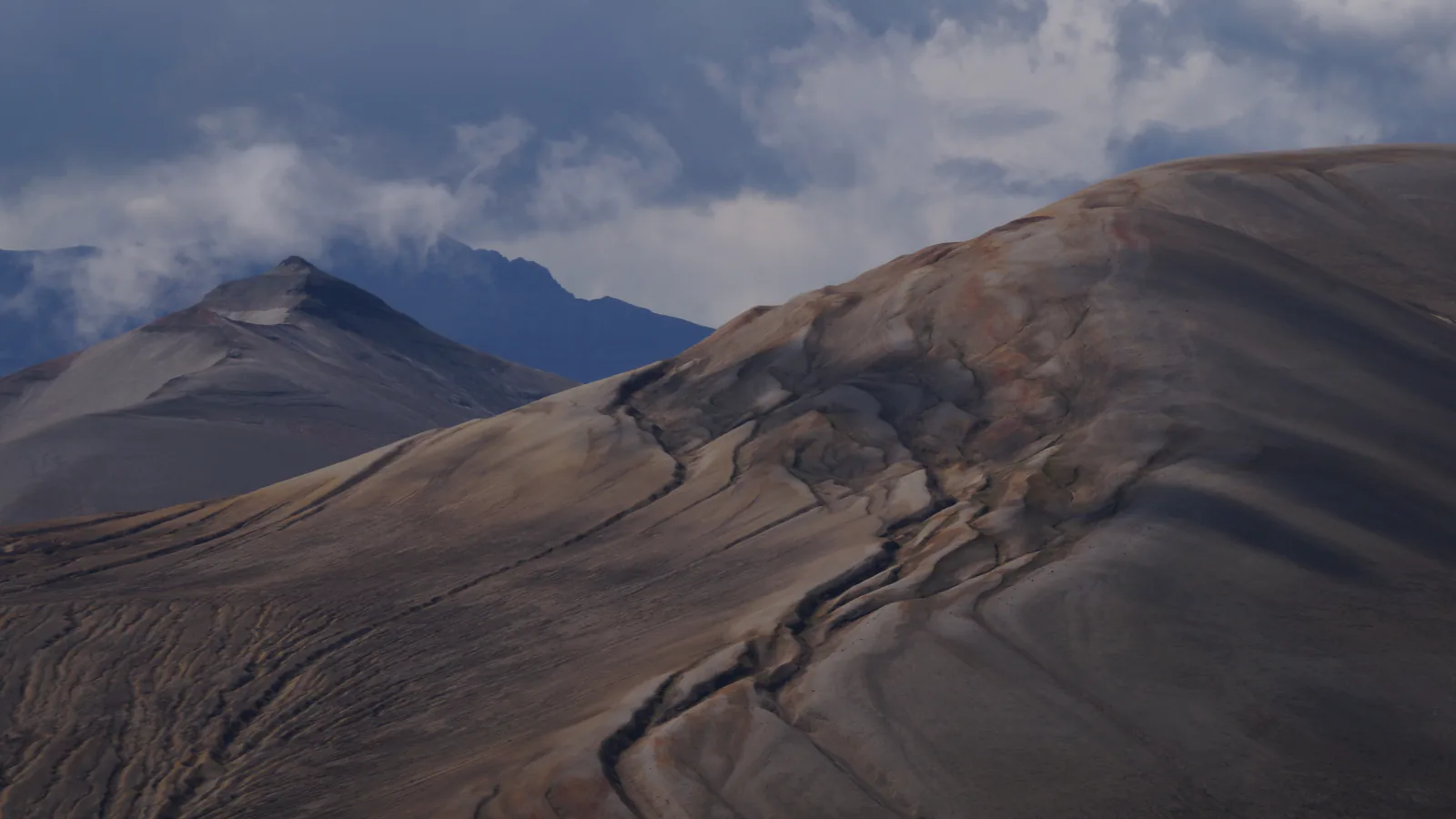
Katmai is not a park where a rental car reaches a menu of signed trailheads. Most visitors arrive at Brooks Camp by floatplane, then move on foot through country shared with brown bears. The Brooks Camp paths are short and managed. The Valley of Ten Thousand Smokes is reached over a remote 23-mile road, and most travel beyond its maintained paths becomes map-and-compass wilderness work.
That makes four hikes the right number here. Brooks Falls and Lake Brooks cover the low routes around camp. Dumpling Mountain is the one established climb with a summit option. Ukak Falls and the Windy Creek overlook provide a practical first walk below Three Forks without implying that Novarupta or the wider valley has a maintained trail all the way.
Late summer has its own rules. The no-entry river zone around Brooks Falls runs from June 15 through August 15 and is often extended through September 30, although the raised viewing platforms remain the proper destination. Every visitor arriving at Brooks Camp must attend the bear orientation, and rangers can pause a trail or bridge when a bear is too close.
What changes a hiking day here
Bear School comes before the trail
The Brooks Camp orientation is mandatory. Bears receive the right-of-way, and visitors must remain at least 50 yards from them unless a ranger directs otherwise. Talk while moving through brush, never run, and follow ranger instructions even when that changes the day's route.
Food rules are unusually strict
Within Brooks Camp, food belongs in designated caches and can be eaten only in buildings or marked picnic areas. Away from those places, carry plain water only. Outside the developed area, scented items and food require approved bear-resistant storage.
Pack rain gear on a clear morning
NPS advises rain jacket and rain pants on every Katmai hike. Cold rain, wind, and low cloud can arrive during summer. On Dumpling Mountain and in the Valley, carry insulation and a navigation backup even when camp feels mild.
Pets do not belong at Brooks Camp in season
Pets and service animals are prohibited within 1.5 miles of the Brooks Falls Platform from May 1 through October 31. Pets may be physically controlled in other backcountry areas, but bringing one into dense bear country adds risk and should be discussed with park staff.
| Trail | Distance | Time | Difficulty | Best for |
|---|---|---|---|---|
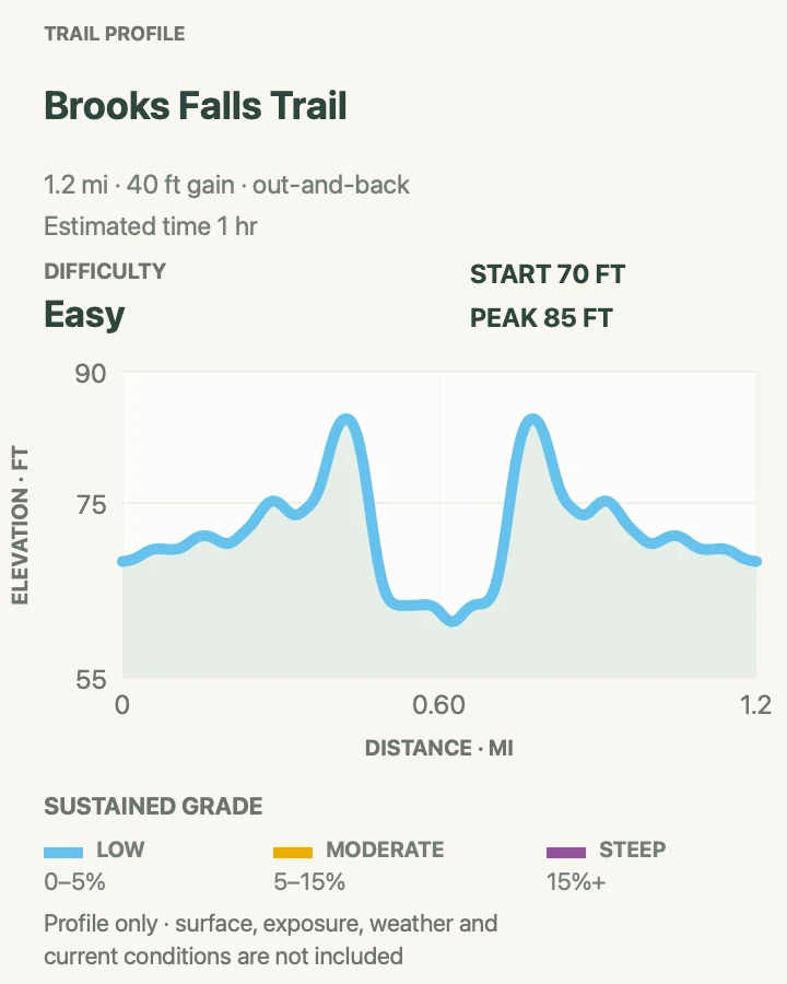
| Brooks Falls Trail | About 1.2 miles for the mapped out-and-back | 1 hr | Easy | Watching brown bears from managed platforms |
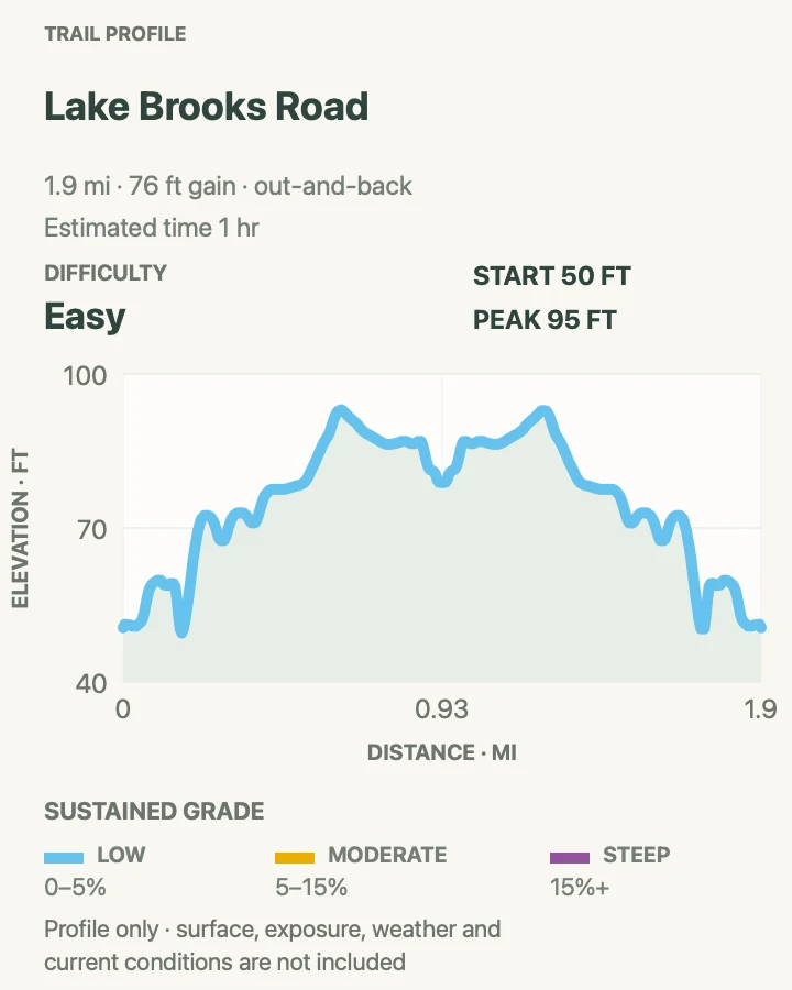
| Lake Brooks Road | About 1.9 miles out and back | 1 hr | Easy | A level camp walk to a glacial lake and picnic shelter |
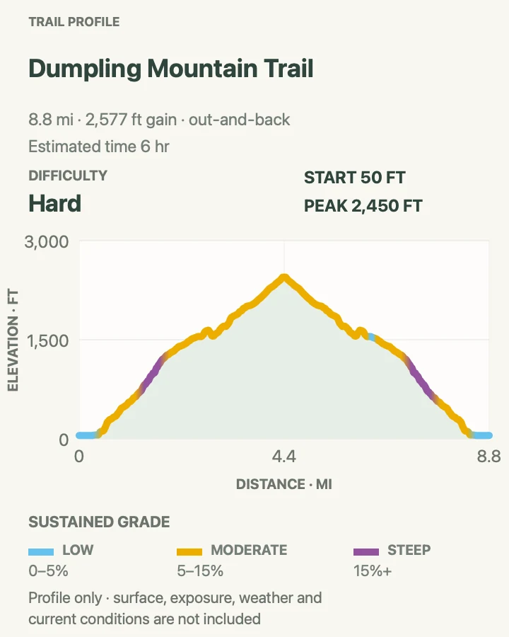
| Dumpling Mountain Trail | About 8.8 miles out and back to the summit; the overlook is much shorter | 6 hr | Hard | The park's established climb from forest to alpine tundra |
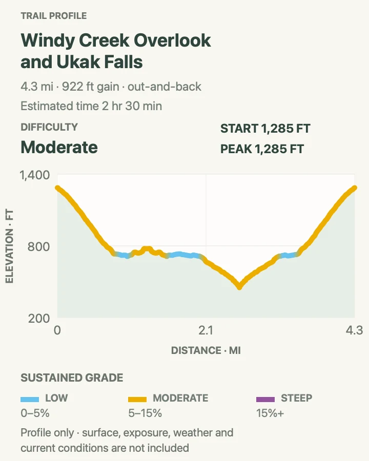
| Ukak Falls and Windy Creek Overlook | About 4.3 miles out and back on the mapped route | 2 hr 30 min | Moderate | A first descent from Three Forks into the volcanic valley |
Brooks Falls Trail
- Distance
- About 1.2 miles for the mapped out-and-back
- Elevation gain
- 40 feet
- Time
- 1 hr
- Difficulty
- Easy
- Route type
- out-and-back
- Parking
- There is no road access from outside the park; begin after bear orientation at Brooks Camp and follow the raised walkway system.
- Best time
- July for the main salmon run, or September for a second period of frequent bear activity.
- Pets
- Pets and service animals are prohibited in the Brooks Camp developed area from May 1 through October 31.
The walk to Brooks Falls passes through boreal forest before reaching raised platforms over the Brooks River. Its grade is easy and much of the route is accessible, but the wildlife setting controls the day. Bears sleep beside the trail, cross under walkways, and use the same corridor between feeding areas.
Rangers may hold hikers at a bridge or trail entrance until a bear moves beyond the regulated distance. At the Falls Platform, capacity is 40 people; when it is full, visits may be limited to one hour. Keep bags within reach, use no flash, and do not stop on connecting walkways to take photographs.
What helps on this route
- Budget for wildlife delays instead of scheduling a tight floatplane connection after the walk.
- The Riffles and Lower River platforms can be productive when the falls platform is crowded.
Terrain and access: Low forest trail, boardwalk and elevated platforms, bridge crossings, bear traffic, temporary ranger holds, wet surfaces, and little elevation change.

Lake Brooks Road
- Distance
- About 1.9 miles out and back
- Elevation gain
- 75 feet
- Time
- 1 hr
- Difficulty
- Easy
- Route type
- out-and-back
- Parking
- Start from the South Platform area at Brooks Camp; continue straight past the Brooks Falls and Valley Road junctions.
- Best time
- August or September, when salmon use the lake outlet and bears may fish nearby.
- Pets
- Seasonal Brooks Camp pet and service-animal restrictions apply.
The camp road reaches Lake Brooks and the head of Brooks River in about one mile. A covered picnic area, food cache, and vault toilet make the lake the only destination in this guide where a meal stop is allowed outdoors. The road also introduces the junction used by Valley of Ten Thousand Smokes traffic.
Easy footing does not remove bear rules. Salmon and bears gather near the outlet in late summer, and the road can function as a travel corridor for wildlife. Make normal conversation, keep all equipment within reach, and give a bear its chosen line rather than crowding the roadside.
What helps on this route
- Carry food in the cache system; do not walk down the road holding a snack.
- Ask a ranger about bear activity at the lake before leaving camp.
Terrain and access: Broad gravel road, very low grade, forest, developed junctions, lake shore, salmon-bearing outlet, and frequent bear awareness.

Dumpling Mountain Trail
- Distance
- About 8.8 miles out and back to the summit; the overlook is much shorter
- Elevation gain
- 2,580 feet
- Time
- 6 hr
- Difficulty
- Hard
- Route type
- out-and-back
- Parking
- The trail begins inside Brooks Camp Campground; reach it on foot after orientation.
- Best time
- A stable summer morning with a clear summit forecast.
- Pets
- Seasonal Brooks Camp pet and service-animal restrictions apply.
The first 1.5 miles climb about 800 feet to an overlook above Brooks Camp, Naknek Lake, Brooks River, and Lake Brooks. That is the sensible turnaround in cloud or rain. The path continues another 2.5 miles toward the 2,440-foot summit, leaving forest for subalpine meadow and tundra.
The full mapped outing approaches nine miles and gains far more than the overlook option. Wind and fog can erase the view and make the upper route difficult to follow. Turn around at the overlook if the summit is hidden, daylight is short, or the group has already used its weather margin.
What helps on this route
- Decide at the overlook; it is a complete hike, not a failed summit attempt.
- Carry rain shell, rain pants, insulation, and an offline map for the exposed upper trail.
Terrain and access: Boreal forest, sustained climb, subalpine meadow, alpine tundra, exposed upper slope, wind, fog, and roughly 2,400 feet from camp to the high point.

Ukak Falls and Windy Creek Overlook
- Distance
- About 4.3 miles out and back on the mapped route
- Elevation gain
- 920 feet
- Time
- 2 hr 30 min
- Difficulty
- Moderate
- Route type
- out-and-back
- Parking
- Reach Three Forks on an authorized Valley of Ten Thousand Smokes trip; the maintained Ukak Falls path begins at the visitor-center steps.
- Best time
- A calm summer day when the Valley road and shuttle are operating.
- Pets
- Ask park staff before bringing any animal into this remote bear country.
From Three Forks, the maintained Ukak Falls Trail descends toward the confluence of the River Lethe, Knife Creek, and Windy Creek. The mapped walk combines the waterfall approach with an overlook toward Windy Creek, giving a close view of the ash-filled valley without committing to a multi-day route toward Novarupta.
Access is the hard part. The single-lane Valley Road has three river fords and is generally reached by a concessioner bus or van from Brooks Camp. Beyond the maintained trail, ash, wind, scarce clear water, and dangerous crossings quickly turn a day walk into a backcountry expedition. Stay with the agreed route and return time.
What helps on this route
- Confirm the shuttle's departure time before descending from Three Forks.
- Do not filter opaque ash-laden river water unless no safer source exists; ask staff about current water options.
Terrain and access: Volcanic ash and pumice, maintained descent near Three Forks, exposed wind, waterfall and creek viewpoints, remote road access, bear country, and abrupt weather.

Official planning sources
Trail access and safety details were checked against these National Park Service pages. The maps and profiles use the reviewed route geometry stored with this guide.
- NPS: Current Katmai alerts and conditions
- NPS: Brooks Camp hiking trails
- NPS: Brooks Camp bear rules
- NPS: Current bear safety and food storage
- NPS: Backcountry regulations and pet restrictions
- NPS: Valley of Ten Thousand Smokes access
- NPS: Valley Road and Three Forks
- NPS: Katmai eating and food storage
Map data © OpenStreetMap contributors. Trail geometry and planning details include National Park Service public information.