8 Best Hikes in Joshua Tree National Park
Eight Joshua Tree hikes through boulder country, cactus gardens, high ridges, and quiet washes, with reviewed maps and profiles.
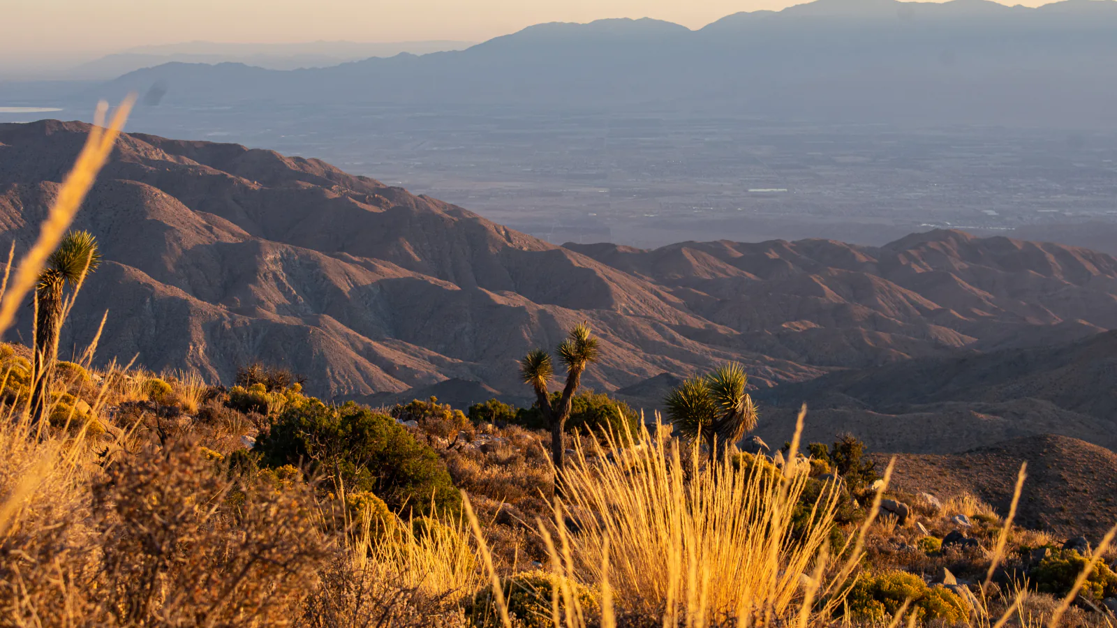
Joshua Tree rewards a mixed hiking day. A quarter-mile walk can pass through a dense cholla stand, while a three-mile summit climbs more than a thousand feet. Farther west, the Black Rock trail network trades roadside boulders for longer Joshua tree valleys and broad views of the San Bernardino Mountains.
These eight hikes are arranged by the kind of outing they create, not by an app's popularity list. Arch Rock, Cholla Cactus Garden, and Skull Rock work as short geology stops. Barker Dam adds cultural history. Ryan Mountain is the concentrated climb. High View, West Side, and Maze/North View make up the quieter Black Rock group.
Summer changes the answer to what counts as a good hike. In August 2026, NPS advises choosing short routes before 10 a.m. or after 4 p.m. and avoiding trails longer than two miles in extreme heat. Park-wide fire restrictions remain in effect through October 1. The center of the park has no potable water.
What changes a hiking day here
Bring water before entering the interior
Carry about four liters per person for a summer day, plus extra water for cooling. Fill stations are at selected entrances, visitor centers, and campgrounds, not at the central trailheads. A short route can still become dangerous after a wrong turn or vehicle problem.
Use the long trails outside summer heat
Ryan Mountain, Maze/North View, and West Side should be treated as cool-season hikes. On a hot day, switch to a short dawn walk or stay near a visitor center. Heat illness can begin before thirst feels urgent.
Download the map and carry a paper backup
Phone service is unreliable, and wash junctions can look alike. Save the NPS map before the drive, carry a compass, and leave the route with someone outside the park. Do not depend on social tracks that wander into climbing approaches.
Pets cannot use the trails
Pets are prohibited on hiking trails and in the backcountry, including when carried. They must remain leashed near roads or in campgrounds, and the 2026 compendium prohibits leaving them in a vehicle when conditions could cause suffering.
| Trail | Distance | Time | Difficulty | Best for |
|---|---|---|---|---|
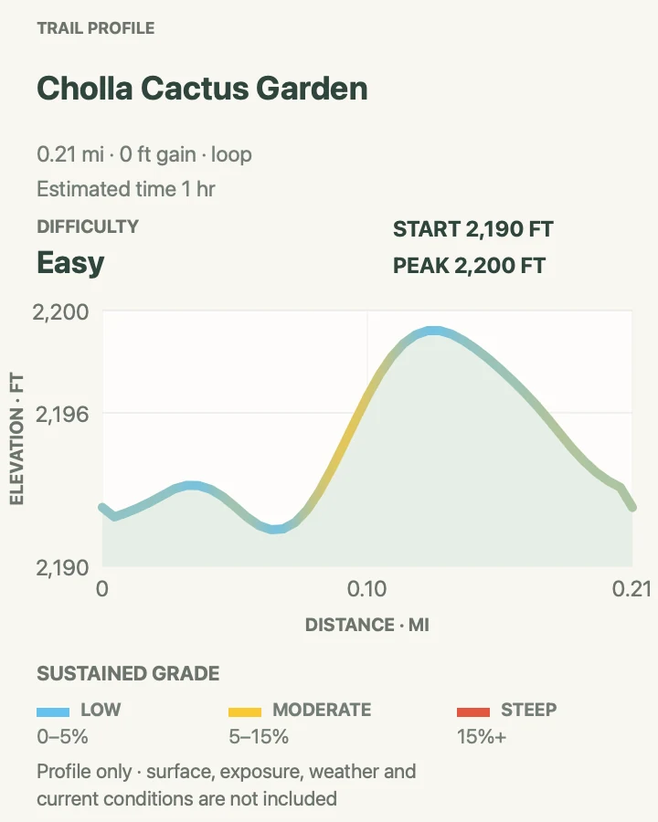
| Cholla Cactus Garden | About 0.2-mile loop | 1 hr | Easy | A short walk through dense teddy bear cholla |
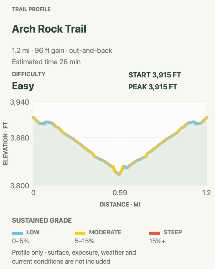
| Arch Rock Trail | About 1.2 miles out and back with a short loop | 26 min | Easy | A compact walk to a natural granite arch |
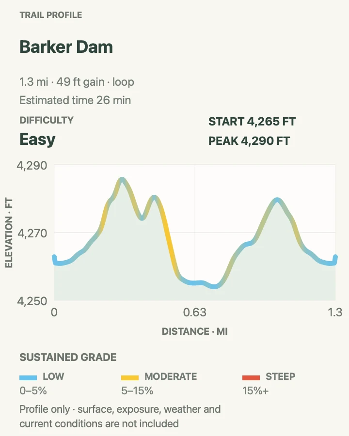
| Barker Dam Nature Trail | About 1.3-mile loop | 26 min | Easy | Boulders, ranching history, desert plants, and protected rock art |
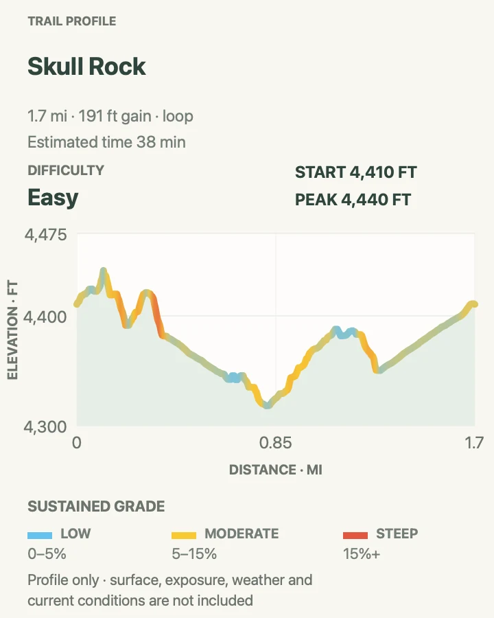
| Skull Rock and Jumbo Rocks Loop | About 1.7-mile loop | 38 min | Easy | A fuller boulder walk than the roadside photo stop |
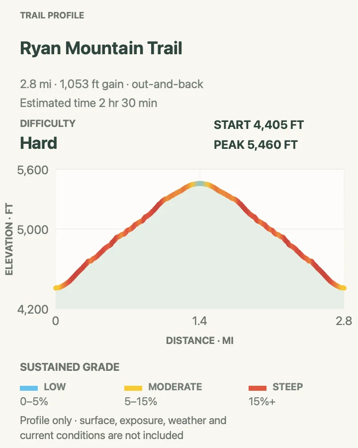
| Ryan Mountain Trail | About 2.9 miles out and back | 2 hr 30 min | Hard | A direct climb to wide central-park views |
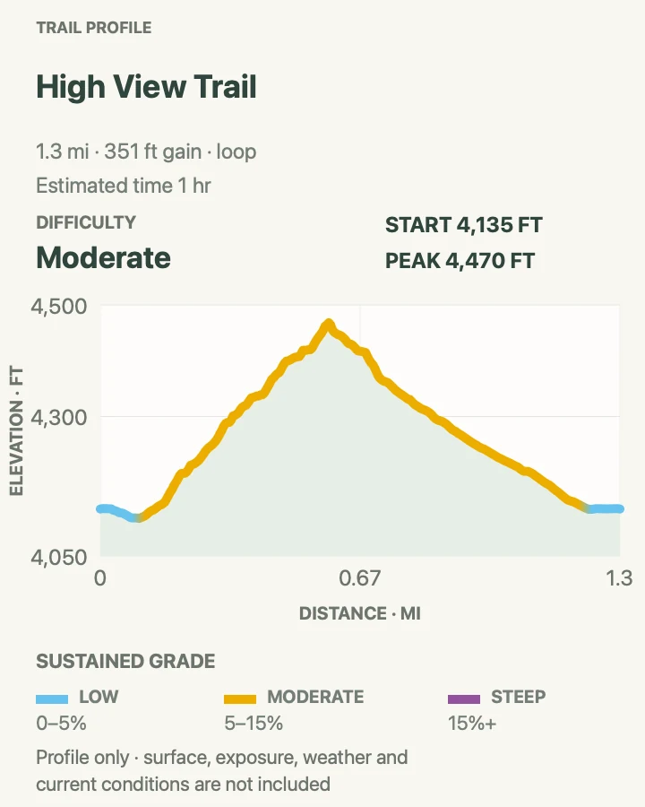
| High View Trail | About 1.3-mile loop | 1 hr | Moderate | A short Black Rock climb above dense Joshua tree woodland |
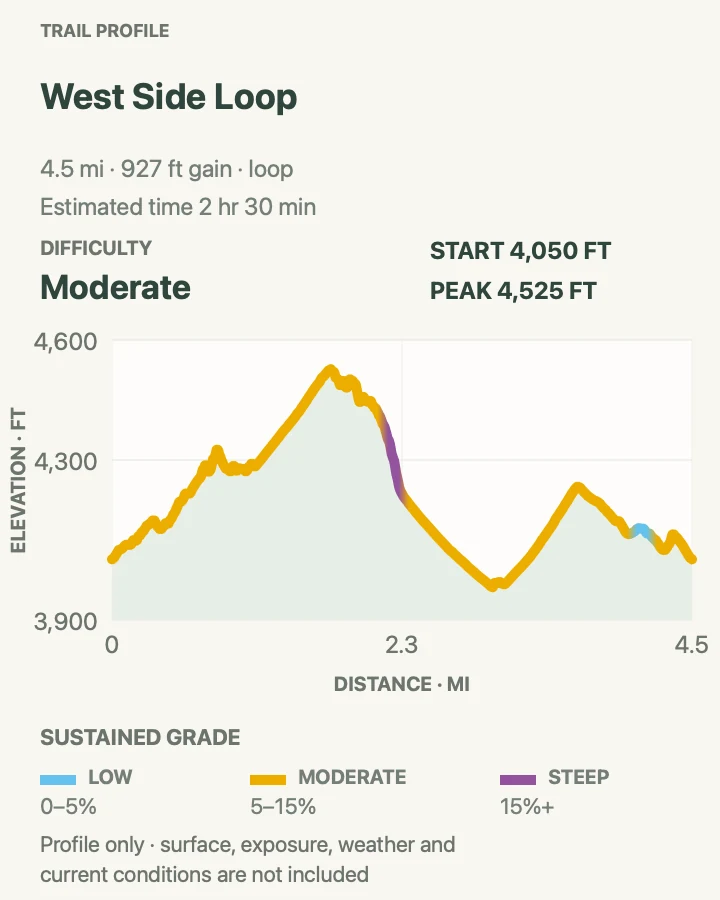
| West Side Loop | About 4.5-mile loop | 2 hr 30 min | Moderate | A half-day Joshua tree and wash circuit near Black Rock |
| Maze and North View Loop | About 6.4-mile loop | 3 hr | Moderate | A longer, quieter Black Rock circuit with broad desert views |
Cholla Cactus Garden
- Distance
- About 0.2-mile loop
- Elevation gain
- 0 feet
- Time
- 1 hr
- Difficulty
- Easy
- Route type
- loop
- Parking
- Use the signed Cholla Cactus Garden lot on Pinto Basin Road.
- Best time
- Sunrise or the final cool hour before sunset, outside excessive heat.
- Pets
- Pets are prohibited on the trail.
This nearly level path enters a natural concentration of teddy bear cholla at the meeting of the Mojave and Colorado deserts. Low light catches the spines, but that glow does not make them soft: detached segments root readily and can puncture shoes and skin.
Stay on the path and wear closed-toe footwear. NPS notes active summer bees around the garden, especially where hikers carry water. Do not swat at them, and leave immediately if an allergic reaction begins.
What helps on this route
- Carry tweezers or a small comb for cactus spines, but never handle a segment bare-handed.
- The trail has no shade or cell service despite its roadside location.
Terrain and access: Nearly level dirt loop, loose cactus segments, no shade, minimal elevation change, exposed sun, and summer bees.

Arch Rock Trail
- Distance
- About 1.2 miles out and back with a short loop
- Elevation gain
- 95 feet
- Time
- 26 min
- Difficulty
- Easy
- Route type
- out-and-back
- Parking
- Park at Twin Tanks; the trailhead is no longer inside White Tank Campground.
- Best time
- Early morning or late afternoon for cooler rock and softer light.
- Pets
- Pets are prohibited on the trail.
A sandy approach leaves Twin Tanks, crosses the campground road, and reaches a small loop among boulders. Arch Rock appears about a tenth of a mile into that loop, with waysides explaining how weathering opened the granite.
The official trail is longer than the old campground-start description still found in some guides. Follow signs from Twin Tanks and account for the road crossings shown on the map. The loop is rocky enough to require attention around the arch.
What helps on this route
- Walk the arch loop counterclockwise; the opening is easier to spot from that direction.
- Keep the trail clear while photographing the arch.
Terrain and access: Sandy connector, paved road crossings, compact desert soil, granite boulders, short rocky loop, no shade, and mild grades.

Barker Dam Nature Trail
- Distance
- About 1.3-mile loop
- Elevation gain
- 50 feet
- Time
- 26 min
- Difficulty
- Easy
- Route type
- loop
- Parking
- Use the Barker Dam trailhead lot; the day-use area is open from one hour before sunrise to one hour after sunset.
- Best time
- Cool morning after rain if reservoir water is part of the plan.
- Pets
- Pets are prohibited on the trail.
The loop threads monzogranite blocks to a small dam built during the area's ranching period. Its reservoir is usually dry; water appears only after enough rain. Interpretive signs continue beyond the dam toward a rock-art site and sandy wash.
View the rock art from the signed area without touching, climbing, or stepping on the boulder. Some markings are faint, and a boot placed for a better angle can damage a feature that was not obvious.
What helps on this route
- Do not promise children a lake; most visits find a dry basin.
- Arrive early on winter and spring weekends because the small lot fills.
Terrain and access: Compact dirt, granite steps, tight boulder passage, sandy wash, mostly gentle grade, interpretive signs, and no dependable water.

Skull Rock and Jumbo Rocks Loop
- Distance
- About 1.7-mile loop
- Elevation gain
- 190 feet
- Time
- 38 min
- Difficulty
- Easy
- Route type
- loop
- Parking
- Use the roadside Skull Rock parking area; day hikers should not occupy reserved campground spaces.
- Best time
- Cool morning in fall, winter, or spring.
- Pets
- Pets are prohibited on the trail.
Skull Rock itself sits only steps from Park Boulevard, but the loop continues through the boulder fields around Jumbo Rocks. Sandy washes, granite corridors, and short steps make the circuit more interesting than a quick stop beside the road.
The path crosses Park Boulevard and touches campground roads. Watch traffic, follow trail markers through the campsite grid, and avoid squeezing into occupied spaces for parking. The rough surface can remain awkward despite the low total climb.
What helps on this route
- Start at the signed Skull Rock lot unless staying in Jumbo Rocks Campground.
- Watch children closely at both road crossings.
Terrain and access: Deep sand, hard-packed soil, uneven granite, short rocky steps, two road crossings, campground segment, and little shade.

Ryan Mountain Trail
- Distance
- About 2.9 miles out and back
- Elevation gain
- 1,050 feet
- Time
- 2 hr 30 min
- Difficulty
- Hard
- Route type
- out-and-back
- Parking
- Use the signed Ryan Mountain lot on Park Boulevard; parking is limited in busy months.
- Best time
- Cool-season morning with a clear forecast.
- Pets
- Pets are prohibited on the trail.
Ryan Mountain gains roughly 1,050 feet in a mile and a half. Stone steps and steep dirt traverse open slopes toward a summit view of Queen, Lost Horse, and Pleasant valleys, with the Little San Bernardino Mountains beyond.
There is almost no shade and no water. NPS specifically advises avoiding Ryan Mountain during summer heat. Strong wind can make the summit uncomfortable even when the trailhead feels calm, so pack a layer in cool months.
What helps on this route
- Set a turnaround point before the exposed upper half.
- Yield at narrow steps instead of passing on loose ground.
Terrain and access: Steep dirt and rock, many stone steps, loose sections, open ridge, about 1,050 feet of gain, wind, and full sun.

High View Trail
- Distance
- About 1.3-mile loop
- Elevation gain
- 350 feet
- Time
- 1 hr
- Difficulty
- Moderate
- Route type
- loop
- Parking
- Start from the Black Rock trail network near the campground and nature center.
- Best time
- A cool clear morning or late afternoon.
- Pets
- Pets are prohibited on the trail.
High View climbs from Black Rock through a thick Joshua tree woodland to an open shoulder with views toward San Gorgonio and the surrounding desert ranges. It gives the west-side district its own concise viewpoint hike, away from the Park Boulevard stops.
Several Black Rock paths begin close together. Use the trailhead map and keep to High View's signed loop rather than drifting onto Panorama or Warren Peak connectors. The elevation gain is modest but concentrated.
What helps on this route
- Fill water at Black Rock before walking away from the developed area.
- Late light improves the view, but leave enough time to read the return junctions.
Terrain and access: Joshua tree woodland, sandy trail, short rocky climb, open viewpoint, signed connectors, limited shade, and moderate grades.

West Side Loop
- Distance
- About 4.5-mile loop
- Elevation gain
- 930 feet
- Time
- 2 hr 30 min
- Difficulty
- Moderate
- Route type
- loop
- Parking
- Begin from Black Rock Campground's signed trail system and use day-use parking only.
- Best time
- Fall through spring, starting early on sunny days.
- Pets
- Pets are prohibited on the trail.
West Side Loop moves beyond the campground into washes, ridges, and broad Joshua tree forest. It has enough distance to feel removed from the developed area without committing to the steeper Warren Peak routes.
The open wash can make the loop's direction difficult to read after footprints multiply. Follow the mapped junctions and ignore informal paths. Water is available at Black Rock, not along the loop.
What helps on this route
- Photograph the Black Rock trail board before starting.
- Avoid the wash during or immediately after a monsoon storm.
Terrain and access: Sandy wash, Joshua tree woodland, rolling ridges, loose rock, multiple junctions, sun exposure, and flash-flood potential.

Maze and North View Loop
- Distance
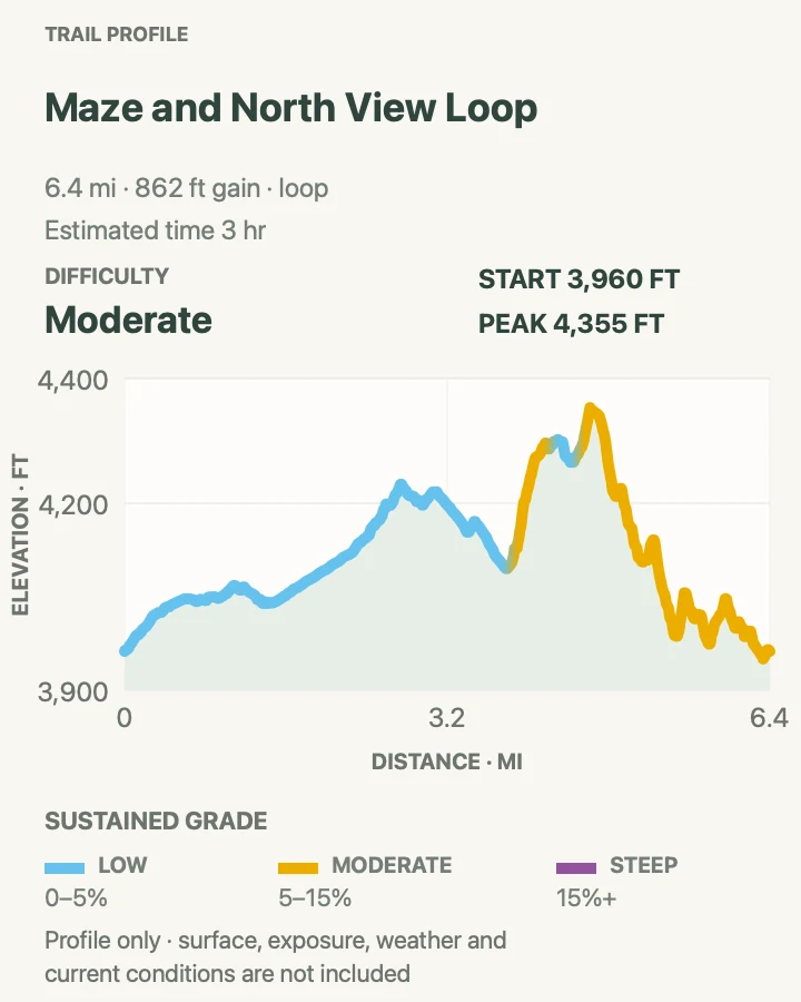
- About 6.4-mile loop
- Elevation gain
- 860 feet
- Time
- 3 hr
- Difficulty
- Moderate
- Route type
- loop
- Parking
- Use the signed Maze Loop trailhead in the Black Rock area and verify the connector before leaving the lot.
- Best time
- A cool-season morning with several hours of daylight.
- Pets
- Pets are prohibited on the trail.
This loop links sandy corridors in the Maze with North View's higher ground. The route shifts between close Joshua trees and open views toward the western park, spreading its climbing across several smaller rises rather than one summit push.
Navigation is the main difficulty. Intersections with horse and hiking routes are not all equally obvious, and cell service is unreliable. Carry both map and compass, then turn back if heat or lost time is reducing the margin.
What helps on this route
- Choose this loop over the shorter Maze version only when the North View mileage adds something to the day.
- Do not start during summer; NPS warns against routes longer than two miles in extreme heat.
Terrain and access: Long sandy loop, Joshua tree woodland, low ridges, several junctions, loose rock, no water, limited shade, and desert navigation.

Official planning sources
Trail access and safety details were checked against these National Park Service pages. The maps and profiles use the reviewed route geometry stored with this guide.
Map data © OpenStreetMap contributors. Trail geometry and planning details include National Park Service public information.