8 Best Hikes in Lassen Volcanic National Park
Eight Lassen hikes to volcano views, hydrothermal basins, lakes, and waterfalls, with reviewed maps, profiles, and current 2026 trail notes.
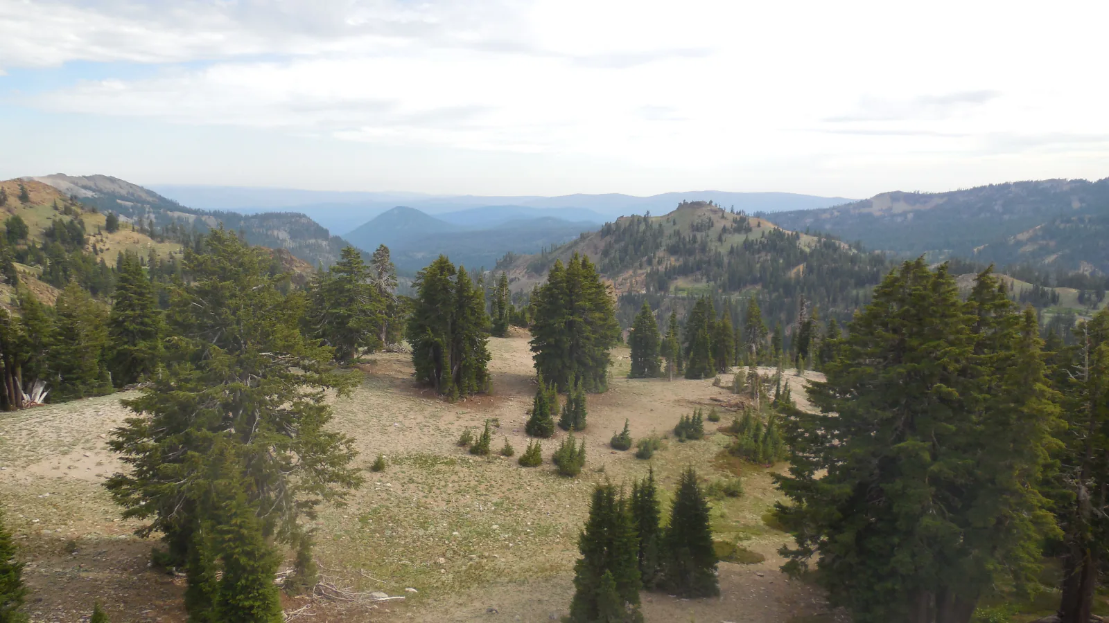
Lassen's road joins two very different hiking districts. Near Manzanita Lake, short paths circle quiet water and cross the debris left by the park's twentieth-century eruptions. South of Lassen Peak, the trails climb abruptly to ridges, lakes, waterfalls, and steaming ground.
This list favors routes that make distinct days. Reflection Lake and Devastated Area take less than an hour. Ridge Lakes and Kings Creek Falls are compact but steep. Brokeoff Mountain is the full-day effort, while the Cold Boiling Lake approach reaches Bumpass Hell from a less familiar direction.
The park's July 18, 2026 report lists all eight trails for hiking. That status does not guarantee dry tread or open road access. Snow can linger at elevation, fire-damaged trees can fall without warning, and weather changes quickly above the forest. Read the current report again on the morning of a long hike.
What changes a hiking day here
Treat hydrothermal ground as a hard boundary
Remain on the trail or boardwalk at Bumpass Hell and Cold Boiling Lake. A surface that looks dry can be a thin crust over acidic, boiling water. Leaving the marked route in a hydrothermal area is illegal as well as dangerous.
Start exposed climbs before storms build
Brokeoff Mountain, Ridge Lakes, and the higher lake corridors have little shelter near their upper sections. Turn down at the first thunder rather than waiting to see lightning. Afternoon wind and hail can arrive after a clear start.
Expect fire effects east of the highway
Mill Creek Falls, Cold Boiling Lake, and Kings Creek Falls cross parts of the 2021 Dixie Fire footprint. Do not linger beneath standing dead trees, especially in wind, and expect sun exposure where the canopy burned.
Leave pets in a safe place outside the trail plan
Pets are prohibited on park trails and in the backcountry, including when carried. They are limited to developed roads, parking areas, campgrounds, and picnic areas under the park's leash rules.
| Trail | Distance | Time | Difficulty | Best for |
|---|---|---|---|---|
| Reflection Lake Route | About 0.7-mile loop | 1 hr | Easy | A gentle lake circuit with Lassen Peak and Chaos Crags views |
| Devastated Area Interpretive Trail | 0.3-mile loop | 1 hr | Easy | A short, accessible introduction to the 1915 eruption |
| Ridge Lakes Trail | About 2.1 miles out and back | 2 hr | Hard | A short, severe climb to two high lakes |
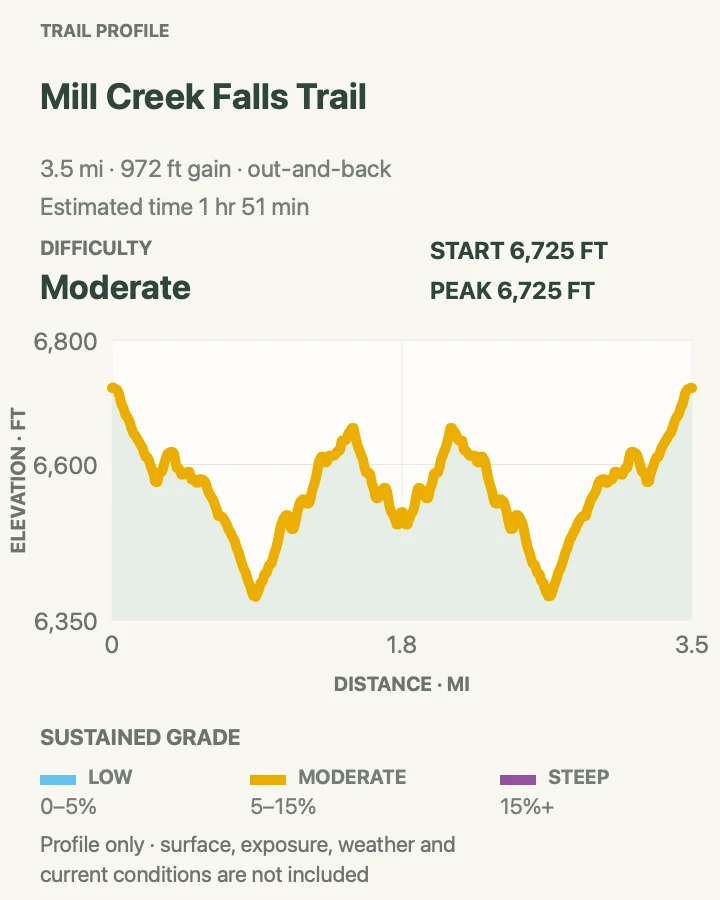
| Mill Creek Falls Trail | About 3.6 miles out and back | 1 hr 51 min | Moderate | A moderate waterfall hike from the main visitor center |
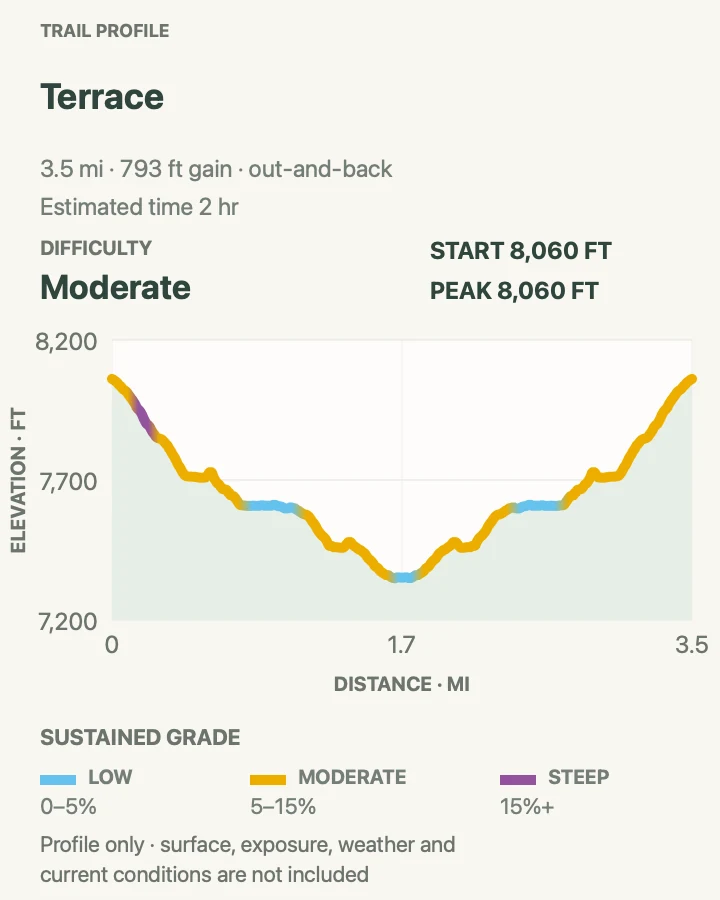
| Terrace, Shadow, and Cliff Lakes | About 3.5 miles out and back | 2 hr | Moderate | Three alpine lakes beneath Reading Peak |
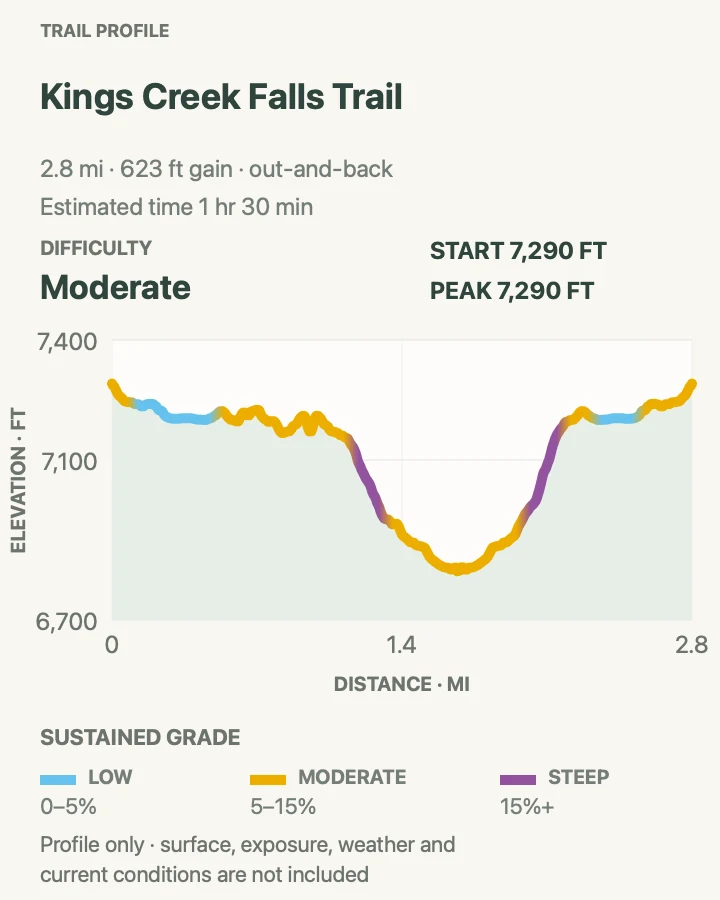
| Kings Creek Falls Trail | About 2.8 miles out and back | 1 hr 30 min | Moderate | A substantial waterfall on a compact route |
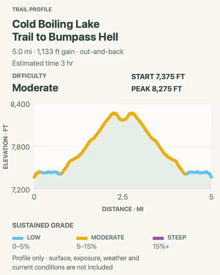
| Cold Boiling Lake to Bumpass Hell | About 5.1 miles out and back | 3 hr | Moderate | A quieter approach to Lassen's largest hydrothermal basin |
| Brokeoff Mountain | About 7.3 miles out and back | 4 hr 47 min | Hard | A strenuous summit day with views across the remains of Mount Tehama |
Reflection Lake Route
- Distance
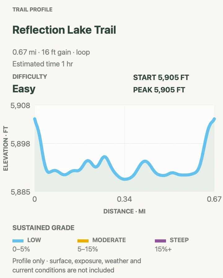
- About 0.7-mile loop
- Elevation gain
- 15 feet
- Time
- 1 hr
- Difficulty
- Easy
- Route type
- loop
- Parking
- Use the signed Reflection Lake pullout near Loomis Plaza at the northwest entrance.
- Best time
- Calm early morning for reflections and bird activity.
- Pets
- Pets are prohibited on the route.
Reflection Lake is the smaller, quieter neighbor of Manzanita Lake. The path follows the shore and overlaps the Lily Pond Interpretive Trail on its eastern side. The open western bank frames Lassen Peak and Chaos Crags when the water is still.
NPS describes this as a route rather than one continuous developed trail. Watch for the interpretive connector, give marshy edges room, and stay on durable tread where the shoreline narrows.
What helps on this route
- Walk clockwise if morning glare is strongest on the east bank.
- Bring binoculars; the shallow water attracts herons, geese, and kingfishers.
Terrain and access: Mostly level lakeshore route, compact soil, roots, short interpretive-trail overlap, marshy margins, and open water views.

Devastated Area Interpretive Trail
- Distance
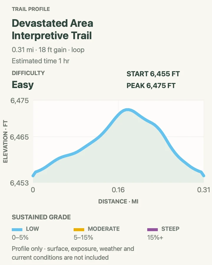
- 0.3-mile loop
- Elevation gain
- 20 feet
- Time
- 1 hr
- Difficulty
- Easy
- Route type
- loop
- Parking
- Use the Devastated Area lot on the park highway north of Lassen Peak.
- Best time
- Any clear summer or autumn hour; late light gives the lava fragments more definition.
- Pets
- Pets are prohibited on the trail.
A compact loop passes boulders and deposits thrown out by Lassen Peak's 1915 eruption. Waysides explain the blast and the forest's return, so the walk earns its place even for visitors capable of much longer mileage.
The tread is broad and nearly level. Shade is scarce, however, and the exposed pavement can feel hot at midday. Do not climb on the volcanic blocks beside the path.
What helps on this route
- Read the first wayside before looking back toward Lassen Peak; the debris field makes more sense with the eruption sequence in mind.
- Pair this walk with Reflection Lake when clouds make the high trails unwise.
Terrain and access: Short paved interpretive loop, minimal grade, open sun, volcanic debris, benches, and exposed summer heat.

Ridge Lakes Trail
- Distance
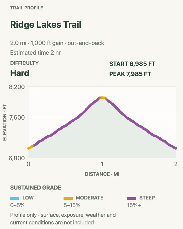
- About 2.1 miles out and back
- Elevation gain
- 1,000 feet
- Time
- 2 hr
- Difficulty
- Hard
- Route type
- out-and-back
- Parking
- Start beside the Kohm Yah-mah-nee Visitor Center at the southwest entrance.
- Best time
- Morning after the snow has melted from the steep upper trail.
- Pets
- Pets are prohibited on the trail.
Ridge Lakes compresses a large climb into barely more than a mile. The trail rises beside Sulphur Works, enters forest, and then reaches a basin below Mount Diller and Brokeoff Mountain. The two lakes can still hold ice after lower paths are dry.
Its mileage tempts rushed decisions. NPS rates the route strenuous and advises poles plus deep-tread boots for the steep ground. Descend carefully; loose soil and tired legs make the return less forgiving than the climb.
What helps on this route
- Give yourself time to adjust to the elevation before leaving the visitor center.
- Turn around if hard snow covers the final grade and you lack suitable traction.
Terrain and access: Very steep forest trail, loose volcanic soil, roots, high basin, lingering snow, lake shore, and rapid descent.

Mill Creek Falls Trail
- Distance
- About 3.6 miles out and back
- Elevation gain
- 970 feet
- Time
- 1 hr 51 min
- Difficulty
- Moderate
- Route type
- out-and-back
- Parking
- Begin behind the Kohm Yah-mah-nee Visitor Center at the southwest entrance.
- Best time
- Morning in late spring or early summer for stronger water flow.
- Pets
- Pets are prohibited on the trail.
The trail drops from the visitor center, crosses forest and fire-affected slopes, then reaches a bridge view of Mill Creek Falls. Tributaries meet at the brink, giving the waterfall more shape than a single narrow chute.
Remember that the return climbs. Parts of the route burned in the Dixie Fire, and standing dead trees remain a hazard. Wind, charred roots, and exposed soil deserve more attention than the moderate distance suggests.
What helps on this route
- Save water and energy for the uphill walk back to the visitor center.
- Do not step off the bridge or onto wet rock for an unobstructed photograph.
Terrain and access: Forest descent, burned slopes, creek crossings, bridge, moderate climbing on return, loose soil, and wet rock near the falls.

Terrace, Shadow, and Cliff Lakes
- Distance
- About 3.5 miles out and back
- Elevation gain
- 790 feet
- Time
- 2 hr
- Difficulty
- Moderate
- Route type
- out-and-back
- Parking
- Use a legal pullout at the signed Terrace Lake trailhead on the park highway; parking is limited.
- Best time
- A cool summer morning after high-elevation snow has cleared.
- Pets
- Pets are prohibited on the trail.
This lake chain begins near the highway and descends past Terrace and Shadow lakes toward Cliff Lake. Each basin has a different view of Reading Peak and the surrounding volcanic ridges, with far fewer interpretive signs than the park's roadside walks.
The loss and recovery of elevation are easy to misread. NPS warns of a steep descent to Shadow Lake and recommends poles. Leave enough strength for the climb back to the highway, and do not park outside the marked spaces.
What helps on this route
- Decide at Shadow Lake whether the added descent to Cliff Lake fits the return climb.
- Mosquitoes can be fierce around the lakes after snowmelt.
Terrain and access: High-elevation forest, three lakes, steep downhill sections, roots, limited sun exposure, mosquitoes, and a sustained return climb.

Kings Creek Falls Trail
- Distance
- About 2.8 miles out and back
- Elevation gain
- 620 feet
- Time
- 1 hr 30 min
- Difficulty
- Moderate
- Route type
- out-and-back
- Parking
- Use the small signed Kings Creek Falls trailhead lot on the park highway.
- Best time
- Early morning in summer, before the limited parking fills and the exposed return heats up.
- Pets
- Pets are prohibited on the trail.
Kings Creek drops from meadow into a rocky gorge before plunging roughly forty feet. The trail starts gently, then loses elevation toward the falls overlook. Open fire-scarred sections now receive more sun than older descriptions imply.
The park recommends poles for the steeper ground. Remain at the established overlook, and allow more time for the climb out than the approach. Standing dead trees are another reason to avoid the route during high wind.
What helps on this route
- Use the signed horse-trail detour if the steep cascade section is posted one-way or closed.
- Carry more water than a 2.8-mile distance normally suggests.
Terrain and access: Meadow, burned forest, rocky descent, steep sections, sun exposure, waterfall overlook, and uphill return.

Cold Boiling Lake to Bumpass Hell
- Distance
- About 5.1 miles out and back
- Elevation gain
- 1,130 feet
- Time
- 3 hr
- Difficulty
- Moderate
- Route type
- out-and-back
- Parking
- Start at Kings Creek Picnic Area and use only the signed spaces along the park highway.
- Best time
- A cool summer morning after the Bumpass basin routes are free of snow.
- Pets
- Pets are prohibited on the trail and boardwalk.
From Kings Creek Picnic Area, the route passes Cold Boiling Lake and Crumbaugh Lake before entering the Bumpass Hell basin from the east. It is longer than the standard highway trail but links lake, burn zone, meadow, and hydrothermal boardwalk in one outing.
Cold Boiling Lake is gentle-looking; Bumpass Hell is not. Stay on every marked segment and boardwalk. The park's rebuilt boardwalk is open from this approach, but seasonal snow and a separate road closure can still remove practical access.
What helps on this route
- Download the park map before leaving because phone service is unreliable.
- Do not touch any thermal water or shortcut across pale ground.
Terrain and access: Lakes, meadow, fire-affected forest, rolling trail, exposed basin, boardwalk, sulfurous steam, and high-elevation weather.

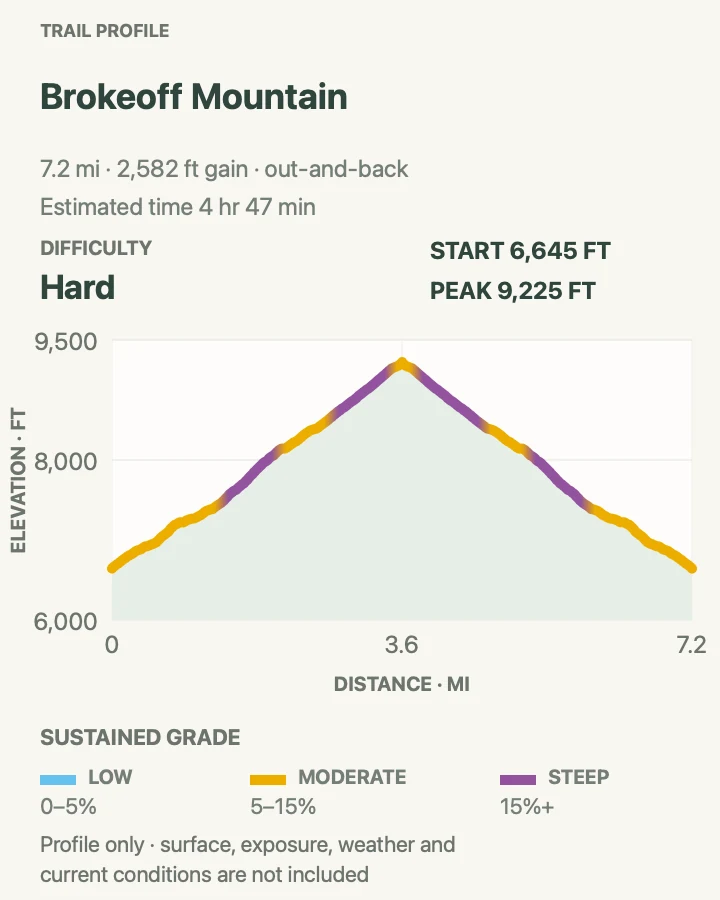
Brokeoff Mountain
- Distance
- About 7.3 miles out and back
- Elevation gain
- 2,580 feet
- Time
- 4 hr 47 min
- Difficulty
- Hard
- Route type
- out-and-back
- Parking
- Use the small Brokeoff Mountain trailhead south of the southwest entrance; arrive early because spaces are limited.
- Best time
- Early morning in the snow-free season with a stable forecast.
- Pets
- Pets are prohibited on the trail.
Brokeoff Mountain climbs through meadow and forest onto the eroded rim of ancient Mount Tehama. The upper trail opens to views of Lassen Peak, Mount Shasta, the Sacramento Valley, and the broken volcanic ridges around the southwest district.
NPS advises trekking poles for the steep, rugged trail. The summit is exposed and far from shelter, so a promising forecast is only a starting condition. Descend immediately when thunder develops, and carry enough water for a climb that gains steadily from the first mile.
What helps on this route
- Set a turnaround time before leaving the trailhead.
- Keep food close; bears are regularly seen in the park's lake and meadow country.
Terrain and access: Long steep climb, meadow, forest, rocky switchbacks, exposed ridge, summit wind, loose tread, and lightning risk.

Official planning sources
Trail access and safety details were checked against these National Park Service pages. The maps and profiles use the reviewed route geometry stored with this guide.
Map data © OpenStreetMap contributors. Trail geometry and planning details include National Park Service public information.