6 Best Hikes in Haleakalā National Park
Six Haleakalā hikes across the summit wilderness and Kīpahulu forest, with reviewed maps, elevation profiles, and current access advice.
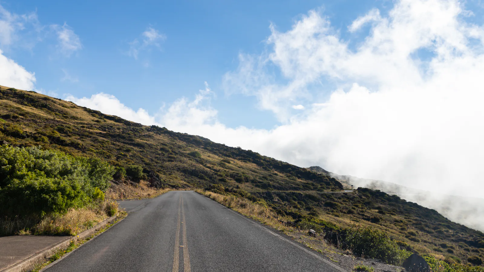
Haleakalā has two hiking worlds separated by a long drive. The Summit District begins near 7,000 feet and drops into a vast volcanic basin. Kīpahulu sits near sea level beyond Hāna, where Pīpīwai Trail follows rainforest and stream toward Waimoku Falls.
The six routes here are intentionally demanding. Several descend thousands of feet before the hard part begins: the climb back to the rim. Supply Trail is the shortest summit choice with a reviewed map, while the Keoneheʻeheʻe-to-Halemauʻu crossing makes the most practical one-day traverse. Pīpīwai supplies the moderate counterpoint.
As of August 2026, the park lists Keoneheʻeheʻe, Halemauʻu, Supply Trail, and Pīpīwai as open. Summit entry between 3 and 7 a.m. requires a sunrise reservation. Access outside that window does not, but every hiker still needs an entrance pass and should check the alerts before the drive.
What changes a hiking day here
Downhill comes first in the crater
A summit hike begins with descent into soft cinder, then asks for the climbing effort at the end. NPS advises allowing about twice as much time to come out as it took to go in. Shorten the route early if altitude, wind, or heat is already slowing the group.
Carry the day's water
There are no dependable natural water sources in the wilderness. Cabin catchment water can be unavailable and must be treated when present. Bring all drinking water for a day hike rather than building the plan around a cabin tank.
Arrange the traverse before walking
The park does not operate a hiker shuttle between Keoneheʻeheʻe and Halemauʻu. Park at the finish and seek a ride to the start before the hike; traffic thins in bad weather and after dark. Do not count on finding a ride after an exhausting descent.
Pets stay off every trail
Dogs are limited to parking lots, roadways, and paved paths. They are prohibited on trails and may not be left unattended. The rule protects rare birds and native plants as well as the animal.
| Trail | Distance | Time | Difficulty | Best for |
|---|---|---|---|---|
| Supply Trail | About 4.8 miles out and back | 3 hr | Moderate | Native shrubland and a quieter approach to Halemauʻu Trail |
| Kapalaoa Cabin via Keoneheʻeheʻe Trail | About 11.7 miles out and back | 6 hr 21 min | Hard | A deep crater day without arranging a second vehicle |
| Keoneheʻeheʻe to Halemauʻu Traverse | About 11.2 miles point to point | 7 hr 49 min | Hard | The classic one-day crater crossing |
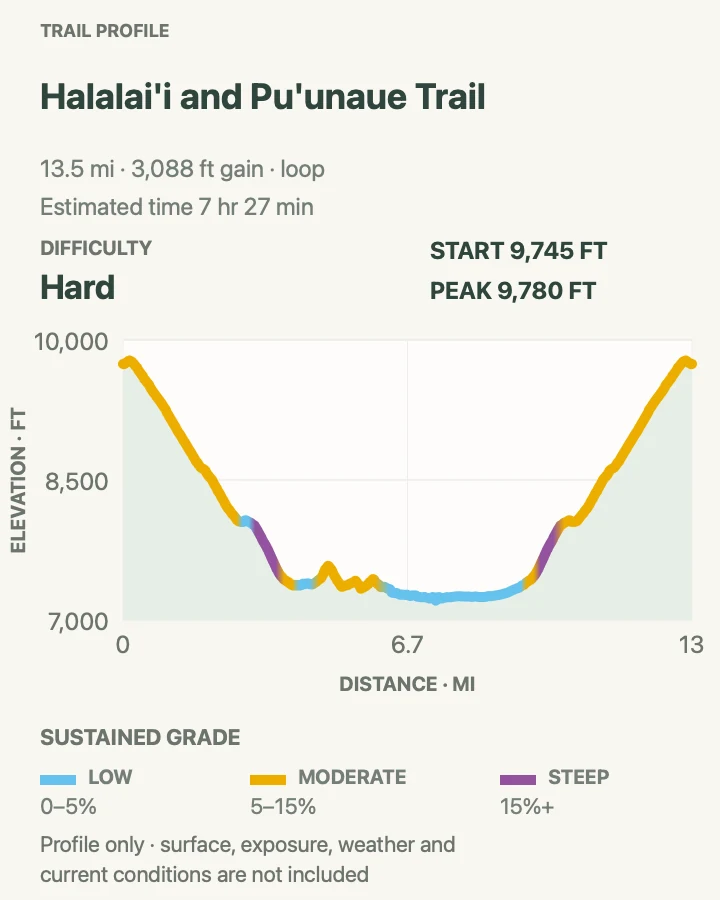
| Halāliʻi and Puʻu Nā ʻUe Loop | About 13.6-mile loop | 7 hr 27 min | Hard | Cinder cones and the quieter interior of the summit wilderness |
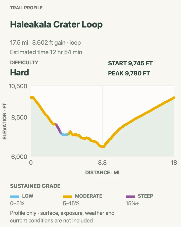
| Haleakalā Crater Grand Loop | About 17.9-mile loop | 12 hr 54 min | Hard | A comprehensive full-day circuit of the summit wilderness |
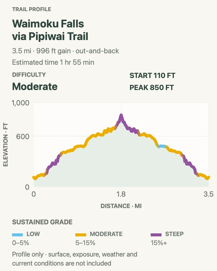
| Pīpīwai Trail to Waimoku Falls | About 3.6 miles out and back | 1 hr 55 min | Moderate | Bamboo, stream crossings, Makahiku Falls, and a tall waterfall finish |
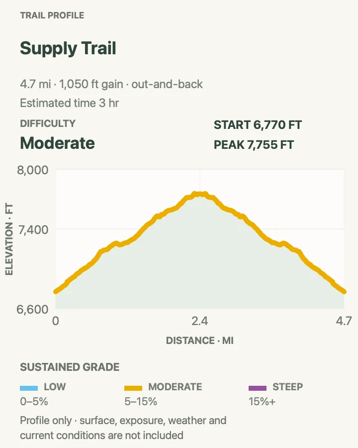
Supply Trail
- Distance
- About 4.8 miles out and back
- Elevation gain
- 1,050 feet
- Time
- 3 hr
- Difficulty
- Moderate
- Route type
- out-and-back
- Parking
- Start at the signed Supply Trail parking area near Hosmer Grove in the Summit District.
- Best time
- Cool morning outside the 3-to-7 a.m. reservation window, or with a valid sunrise booking.
- Pets
- Pets are prohibited on the trail.
Supply Trail climbs from the Hosmer Grove area through subalpine shrubland to meet Halemauʻu Trail. The change from planted forest near the road to open native vegetation happens gradually, with chances to hear or see Hawaiian honeycreepers around the lower trail.
The junction is the sensible turnaround for this mapped hike. Continuing toward the crater rim adds exposed mileage and a much longer return. Fog can erase distant landmarks, so keep track of the same junctions on the way down.
What helps on this route
- Disinfect footwear before the hike to reduce the spread of Rapid ʻŌhiʻa Death.
- Carry a warm layer even when Hosmer Grove feels mild.
Terrain and access: Subalpine shrubland, forest edge, steady volcanic tread, exposed upper trail, fog, wind, and about 1,000 feet of climbing.

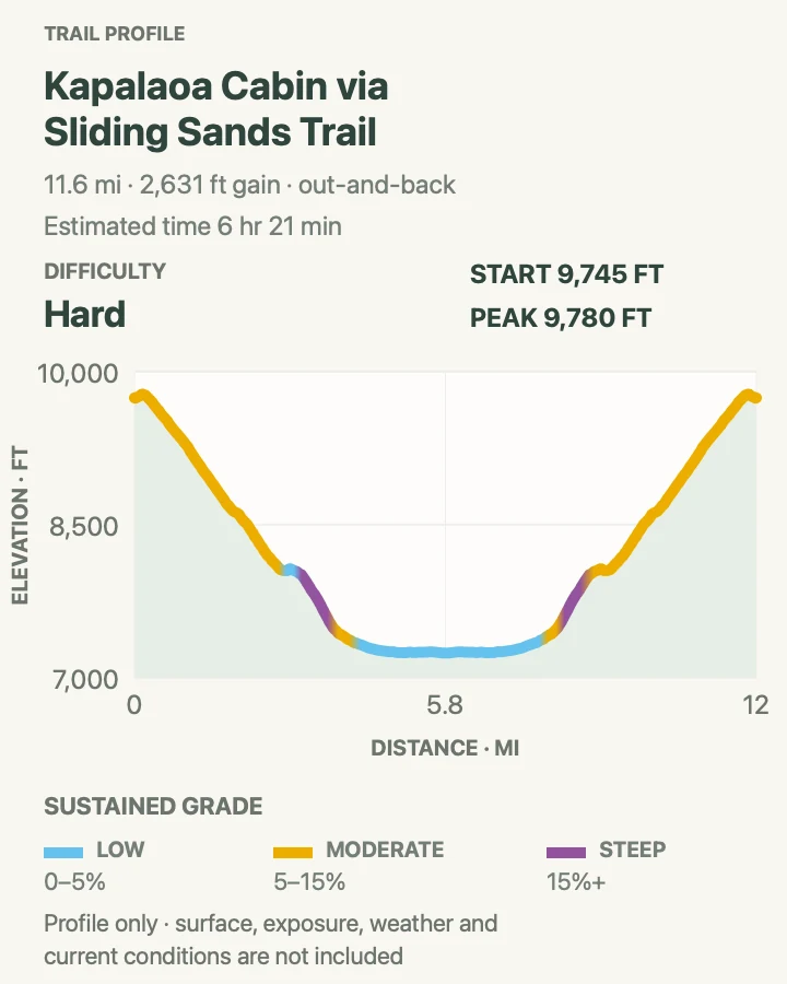
Kapalaoa Cabin via Keoneheʻeheʻe Trail
- Distance
- About 11.7 miles out and back
- Elevation gain
- 2,630 feet
- Time
- 6 hr 21 min
- Difficulty
- Hard
- Route type
- out-and-back
- Parking
- Use the Haleakalā Visitor Center lot near the Keoneheʻeheʻe trailhead; sunrise-hour entry requires a reservation.
- Best time
- An early, clear morning with a firm turnaround time.
- Pets
- Pets are prohibited in the wilderness.
Keoneheʻeheʻe, often called Sliding Sands, drops from the rim across loose cinder toward the crater floor and Kapalaoa Cabin. The route passes stark color bands and low silversword country before reaching the historic cabin area.
The cabin is not a water guarantee, a lunch shelter, or a reason to overextend the day. Every descending foot must be climbed on the return to 9,740 feet. Keep twice the outbound time for the ascent and turn earlier if altitude symptoms appear.
What helps on this route
- Do not approach or feed nēnē near the trailhead or cabin.
- A brim, sunglasses, and rain shell all belong in the same pack.
Terrain and access: Soft cinder, high-altitude desert, sustained descent and ascent, exposed sun, strong wind, cold rain, and little shade.

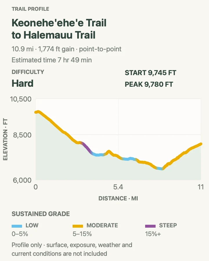
Keoneheʻeheʻe to Halemauʻu Traverse
- Distance
- About 11.2 miles point to point
- Elevation gain
- 1,770 feet
- Time
- 7 hr 49 min
- Difficulty
- Hard
- Route type
- point-to-point
- Parking
- Leave the vehicle at Halemauʻu Trailhead, then arrange a ride to Keoneheʻeheʻe near Haleakalā Visitor Center.
- Best time
- A stable-weather morning after transportation has been settled.
- Pets
- Pets are prohibited on both trails.
The traverse descends Keoneheʻeheʻe to the crater floor, passes Halāliʻi and colorful cinder deposits, then climbs Halemauʻu's long switchbacks to the lower trailhead. Because the finish is roughly 1,750 feet below the start, it avoids reclimbing all the way to the visitor center.
It is still a hard day at elevation. The final switchbacks arrive after miles of soft cinder, and the rim may be windy or hidden in cloud. Parking at the finish first removes the worst logistical gamble.
What helps on this route
- Photograph the trailhead map and cabin junctions before entering the crater.
- Leave no gear at the hiker pickup point and never stop traffic in the road.
Terrain and access: Long volcanic descent, cinder plain, crater-floor junctions, steep switchbacks, narrow pali tread, wind, fog, and altitude.

Halāliʻi and Puʻu Nā ʻUe Loop
- Distance
- About 13.6-mile loop
- Elevation gain
- 3,090 feet
- Time
- 7 hr 27 min
- Difficulty
- Hard
- Route type
- loop
- Parking
- Begin at Keoneheʻeheʻe Trail near Haleakalā Visitor Center and comply with sunrise-hour entry rules.
- Best time
- A long clear day with an early start and no storm forecast.
- Pets
- Pets are prohibited in the wilderness.
This crater-floor circuit uses Keoneheʻeheʻe and interior connectors around Halāliʻi and Puʻu Nā ʻUe. It spends more time among cinder cones than the direct traverse and gives the basin's scale time to unfold rather than treating the floor as a crossing.
Names and junction signs matter because several cabin and crater routes share the same approach. Carry the official park map, remain on marked tread, and plan the final rim climb before choosing any optional spur.
What helps on this route
- Use landmarks and a compass together when cloud lowers over the basin.
- Avoid stepping toward silverswords for photographs; the volcanic soil around them is easily damaged.
Terrain and access: High desert, loose cinder, multiple signed junctions, prolonged exposure, deep descent, strenuous climb, wind, and poor phone service.

Haleakalā Crater Grand Loop
- Distance
- About 17.9-mile loop
- Elevation gain
- 3,600 feet
- Time
- 12 hr 54 min
- Difficulty
- Hard
- Route type
- loop
- Parking
- Start near Haleakalā Visitor Center; verify the exact loop and road access with a ranger before leaving.
- Best time
- A very early start on a dry, stable day for highly fit hikers acclimated to elevation.
- Pets
- Pets are prohibited in the wilderness.
The grand loop combines Keoneheʻeheʻe, crater-floor connectors, and Halemauʻu country into the longest one-day option in this guide. It reaches cinder cones, broad lava fields, native shrubland, and the immense switchback wall in a single circuit.
Nearly eighteen miles of cinder at high altitude is not a casual extension of the standard traverse. This route can take all available daylight. Carry emergency layers and food, share the exact itinerary, and turn it into an overnight trip only with advance camping or cabin reservations.
What helps on this route
- Set both a time limit and a weather limit before entering the basin.
- A satellite messenger can shorten the delay in an emergency, but it does not replace conservative choices.
Terrain and access: Very long high-altitude loop, soft cinder, lava, exposed basin, steep switchbacks, cold wind, changing visibility, and scarce water.

Pīpīwai Trail to Waimoku Falls
- Distance
- About 3.6 miles out and back
- Elevation gain
- 1,000 feet
- Time
- 1 hr 55 min
- Difficulty
- Moderate
- Route type
- out-and-back
- Parking
- Use the Kīpahulu Visitor Center lot at the end of the Hāna Highway drive.
- Best time
- Morning before heat and heavy rain build; allow ample time for the slow coastal road.
- Pets
- Pets are prohibited on the trail.
Pīpīwai climbs beside ʻOheʻo Gulch through dense vegetation, passes the Makahiku Falls overlook, and crosses boardwalks through bamboo before reaching the designated view of Waimoku Falls. The damp forest feels unrelated to the summit, even though both districts belong to the same volcano.
Stop at the signed endpoint. Rockfall and sudden water make the ground beneath waterfalls dangerous, and off-trail travel is illegal. The park also warns that water in Kīpahulu can rise several feet within minutes during a flash flood.
What helps on this route
- Check posted closures at Kīpahulu Visitor Center before starting.
- Use shoes with grip; boardwalk and stone can remain slick long after rain.
Terrain and access: Humid forest, roots, stone steps, stream crossings, bamboo boardwalk, mud, waterfall overlooks, heat, and flash-flood exposure.

Official planning sources
Trail access and safety details were checked against these National Park Service pages. The maps and profiles use the reviewed route geometry stored with this guide.
Map data © OpenStreetMap contributors. Trail geometry and planning details include National Park Service public information.