9 Best Hikes in Kings Canyon National Park
Nine Kings Canyon hikes through sequoia groves, granite canyon, waterfalls, and wilderness, with reviewed maps, profiles, and 2026 access notes.
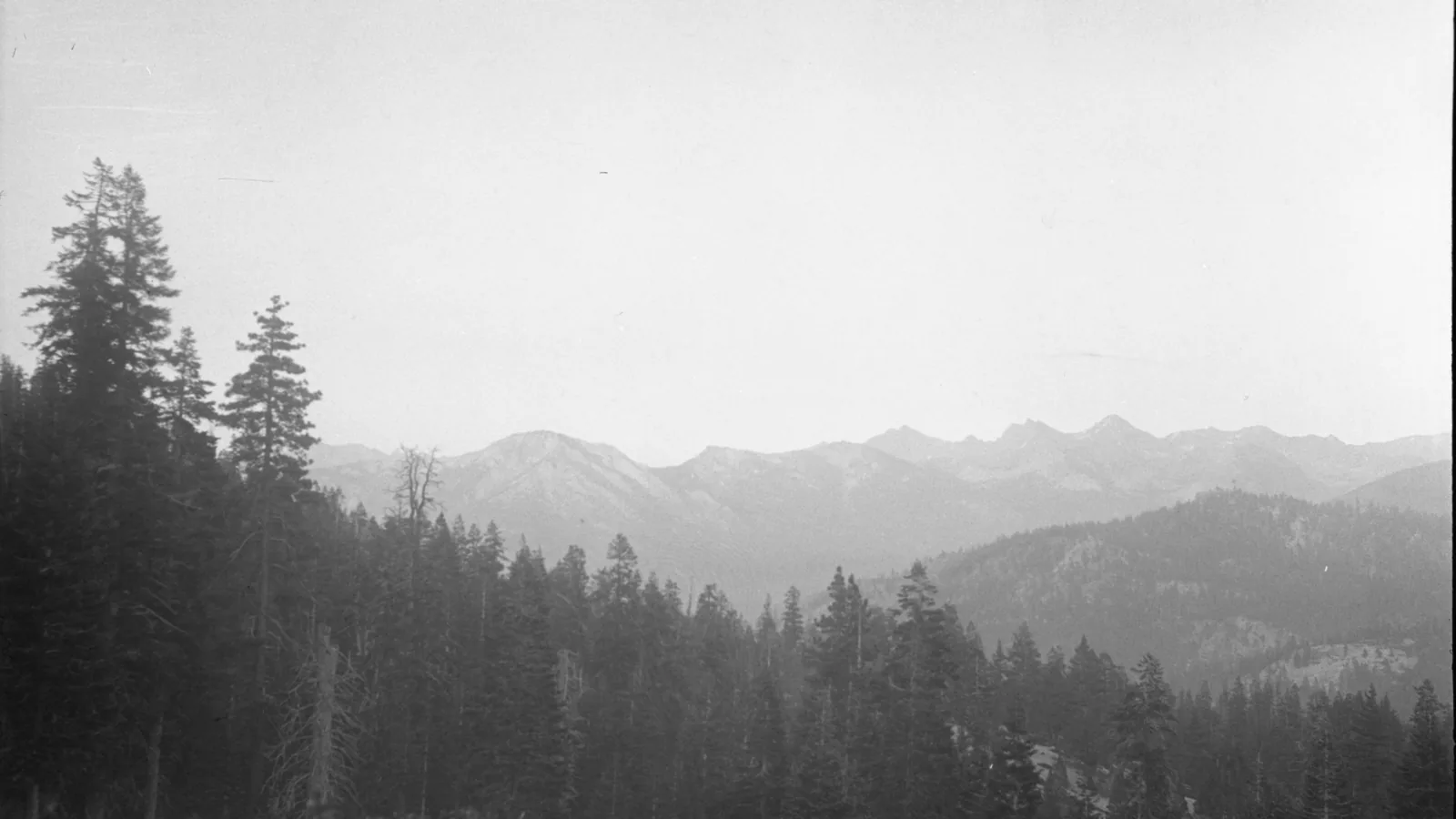
Kings Canyon has two very different hiking centers. Grant Grove sits among giant sequoias near the western entrance. Cedar Grove lies far to the east at the end of Highway 180, deep between granite walls and beside the Kings River. Driving between them takes much longer than the map suggests.
These nine hikes are grouped by the day they create, not by crowd size. Big Stump and North Grove focus on sequoia history. Ella and Viola falls add forest mileage. Panoramic Point looks into the high country. Down in Cedar Grove, the routes follow meadow, river, and the Road's End approach toward Paradise Valley.
As of August 2026, Grant Grove trails, Panoramic Point Road, Highway 180 to Road's End, and Cedar Grove trails are open. The Road's End permit station is operating during the quota season. Conditions change after fire, storms, snowmelt, and tree fall, so check the park report again before a long route.
What changes a hiking day here
Do not plan on a Grant Grove shuttle
The old Big Trees Transit service no longer operates in Grant Grove. Drive to the correct trailhead, and remember that Panoramic Point Road is narrow and closed to motor homes and trailers.
Keep away from cold, fast water
Drowning is the leading cause of death in these parks. Snowmelt makes the Kings River and its branches icy and powerful. Stay off wet rocks and unstable banks, and turn around rather than attempting a crossing that cannot be made safely.
Store every scented item
Black bears live throughout the park. Use trailhead food boxes where supplied, keep food within arm's reach while hiking, and never leave coolers or scented gear visible in a vehicle. Backpackers must follow the route-specific container rules.
Leave pets out of the trail plan
Pets are prohibited on every park trail, including paved trails, and are limited to roads, parking areas, campgrounds, and picnic areas. Carriers and strollers do not create an exception.
| Trail | Distance | Time | Difficulty | Best for |
|---|---|---|---|---|
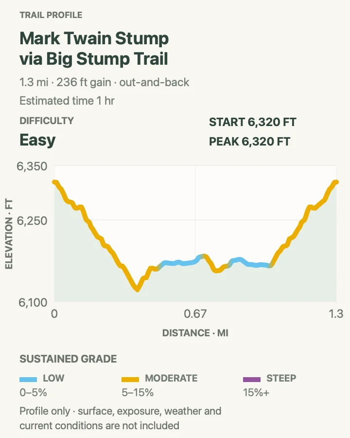
| Big Stump Trail to Mark Twain Stump | About 1.3 miles out and back | 1 hr | Easy | Sequoia logging history and a short family walk |
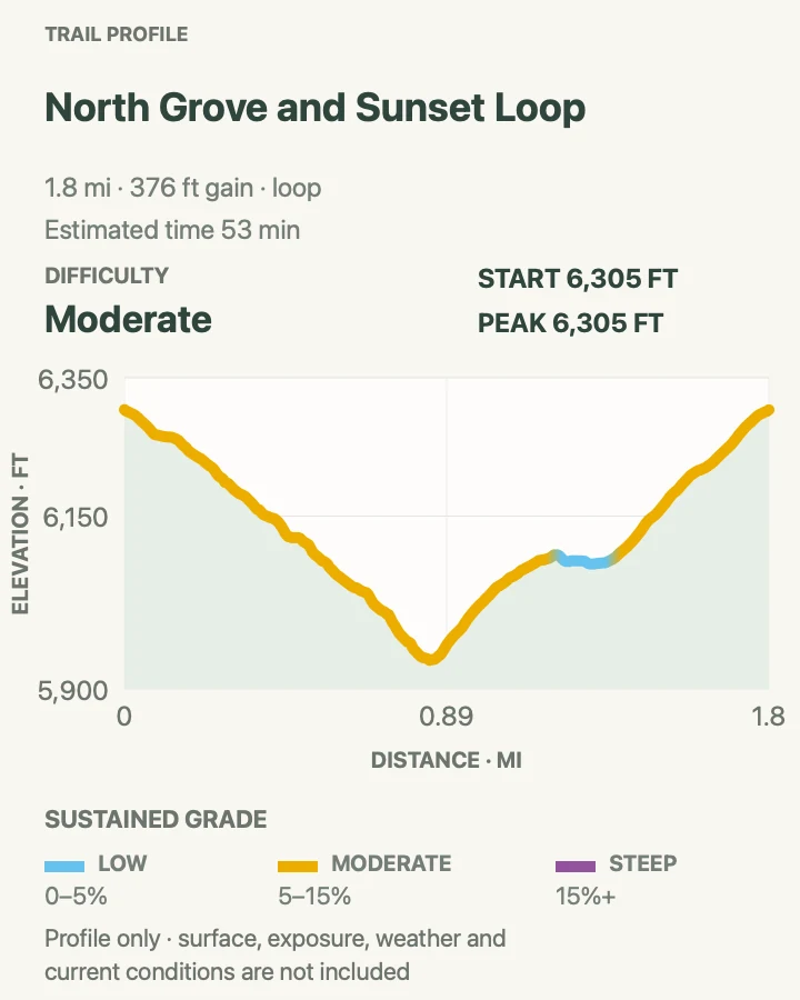
| North Grove and Sunset Loop | 1.8-mile loop | 53 min | Moderate | A calm sequoia walk beyond the busiest Grant Tree path |
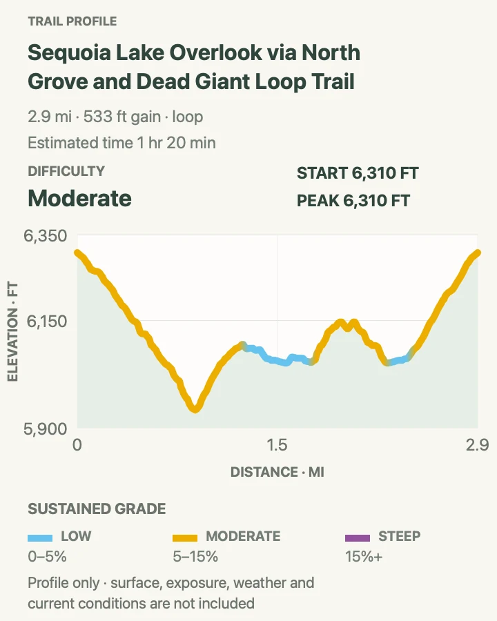
| North Grove and Dead Giant Loop to Sequoia Lake Overlook | 3-mile loop | 1 hr 20 min | Moderate | A longer grove circuit with forest history and an overlook |
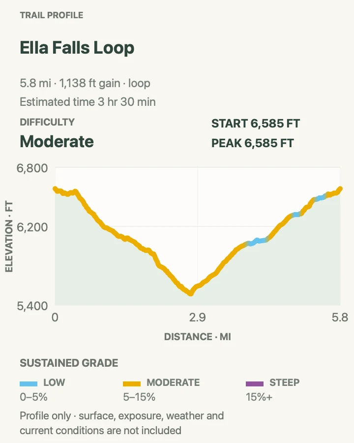
| Ella Falls Loop | 5.8-mile loop | 3 hr 30 min | Moderate | A half-day forest loop from Grant Grove |
| Viola Falls | 3.9 miles out and back | 2 hr 30 min | Moderate | A quieter waterfall objective in the Grant Grove forest |
| Panoramic Point | 0.5-mile loop | 14 min | Easy | A short high-country view of Hume Lake and the Sierra |
| Zumwalt Meadow and Roaring River Falls | About 4.2 miles out and back | 1 hr 35 min | Easy | Granite walls, river forest, meadow views, and a powerful waterfall |
| Road's End to Bailey Bridge | About 4.6-mile loop | 1 hr 32 min | Moderate | An easy introduction to the wilderness corridor beyond Road's End |
| Paradise Valley Trail | About 18.1 miles out and back | 7 hr 44 min | Hard | Experienced hikers seeking a long Kings River canyon day |
Big Stump Trail to Mark Twain Stump
- Distance
- About 1.3 miles out and back
- Elevation gain
- 240 feet
- Time
- 1 hr
- Difficulty
- Easy
- Route type
- out-and-back
- Parking
- Use Big Stump Picnic Area just beyond the Highway 180 entrance station.
- Best time
- Morning from late spring through autumn, or as a snow walk when access and footing allow.
- Pets
- Pets are prohibited on the trail.
The path drops into a grove cut heavily during the nineteenth century. Mark Twain Stump and other enormous remains make the loss tangible, while younger sequoias show how the forest continues around the scars.
NPS describes Big Stump as a two-mile loop; the reviewed route is a shorter out-and-back to Mark Twain Stump. Follow park signs if completing the full loop, and remember that the return climbs to the picnic area.
What helps on this route
- Read the exhibits before deciding that a stump is merely a photo platform.
- Give wildlife in the meadow plenty of room.
Terrain and access: Forest path, meadow edge, roots, old logging remnants, moderate return climb, and seasonal snow or mud.

North Grove and Sunset Loop
- Distance
- 1.8-mile loop
- Elevation gain
- 380 feet
- Time
- 53 min
- Difficulty
- Moderate
- Route type
- loop
- Parking
- Start at the General Grant Tree parking area or signed overflow lot.
- Best time
- A quiet morning or late afternoon outside icy winter conditions.
- Pets
- Pets are prohibited on the trail.
North Grove passes meadows, creeks, mixed conifers, and giant sequoias with fewer people than the short General Grant Tree loop. The Sunset connection adds a little elevation and completes a compact circuit.
There is no local shuttle, so note the exact parking lot before following connectors. Fallen branches, snow, and wet roots can slow this gentle-looking route.
What helps on this route
- Walk softly around meadow edges where deer may feed.
- Carry traction when shaded sections remain icy after the road clears.
Terrain and access: Sequoia and conifer forest, meadow edge, creek crossings, roots, rolling grades, shade, and seasonal snow.

North Grove and Dead Giant Loop to Sequoia Lake Overlook
- Distance
- 3-mile loop
- Elevation gain
- 530 feet
- Time
- 1 hr 20 min
- Difficulty
- Moderate
- Route type
- loop
- Parking
- Use the Grant Tree area and verify the correct North Grove connector at the trailhead map.
- Best time
- Late spring through fall after snowmelt.
- Pets
- Pets are prohibited on the trail.
This loop extends beyond North Grove toward Dead Giant and the Sequoia Lake overlook. It trades the paved feel of the Grant Tree area for quieter forest, old fire and logging evidence, and several junctions.
Sequoia Lake lies outside the park boundary and the overlook is the turnaround view, not permission to descend onto private property. Use the park map at every junction and return by the signed loop.
What helps on this route
- Photograph the junction map because several grove trails share the first section.
- Remain on park trail at the overlook.
Terrain and access: Mixed-conifer and sequoia forest, rolling dirt path, several junctions, roots, fire history, and a distant lake view.

Ella Falls Loop
- Distance
- 5.8-mile loop
- Elevation gain
- 1,140 feet
- Time
- 3 hr 30 min
- Difficulty
- Moderate
- Route type
- loop
- Parking
- Begin from the Grant Grove trail network near the visitor center and confirm the signed connector before leaving the developed area.
- Best time
- Late spring for stronger flow or autumn for cooler forest walking.
- Pets
- Pets are prohibited on the trail.
Ella Falls sits within the web of forest trails around Grant Grove. The loop links quieter conifer stands, creek corridors, and modest climbs rather than one continuous viewpoint route.
Waterfall flow changes sharply by season. Do not scramble on wet rock for a closer view, and check locally for downed trees because current park reports are more reliable than an old track after storms.
What helps on this route
- Carry a printed Grant Grove trail map for the junctions.
- Treat the falls as a turnaround if the loop beyond is blocked or unclear.
Terrain and access: Forest singletrack, creekside tread, roots, several junctions, moderate hills, wet rock near the falls, and seasonal tree fall.

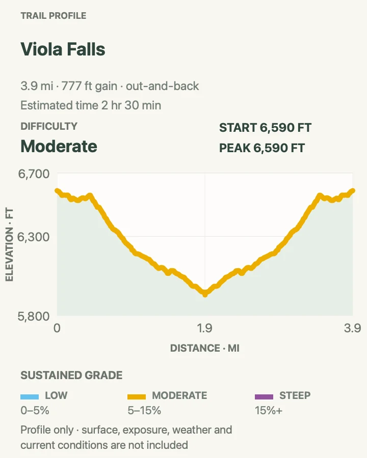
Viola Falls
- Distance
- 3.9 miles out and back
- Elevation gain
- 780 feet
- Time
- 2 hr 30 min
- Difficulty
- Moderate
- Route type
- out-and-back
- Parking
- Use a legal Grant Grove trailhead and confirm the approach with the visitor center before starting.
- Best time
- Late spring or early summer while flow remains, starting before afternoon heat.
- Pets
- Pets are prohibited on the trail.
Viola Falls provides a focused out-and-back through conifer forest. The destination is modest beside Cedar Grove's roaring river, but the route offers solitude and a useful middle distance between the grove loops and full-day hikes.
Local tread and water levels vary. Use signed park routes, avoid wet slabs at the falls, and turn back if storm damage or fallen trees obscure the path.
What helps on this route
- Ask the Kings Canyon Visitor Center for the freshest junction description.
- Bring insect repellent during wet early-summer weeks.
Terrain and access: Shaded conifer forest, dirt tread, roots, creek drainage, moderate climbing, fallen-tree potential, and slick rock near water.

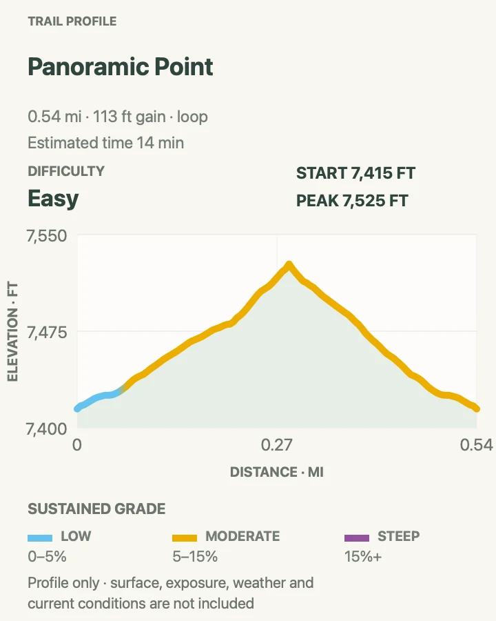
Panoramic Point
- Distance
- 0.5-mile loop
- Elevation gain
- 110 feet
- Time
- 14 min
- Difficulty
- Easy
- Route type
- loop
- Parking
- Drive the narrow seasonal road from Grant Grove Village; RVs and trailers are prohibited.
- Best time
- Clear morning or sunset when Panoramic Point Road is open.
- Pets
- Pets are prohibited on the trail.
A paved, moderately steep path climbs from the picnic area to a view across Hume Lake and deep into Sierra wilderness. Benches and exhibits make it a good stop for hikers who do not want a long forest route.
The road closes when snow makes it impassable and is never suitable for trailers or motor homes. Its narrow width demands slow driving and patience at oncoming traffic.
What helps on this route
- Check Panoramic Point Road status rather than assuming the highway opening includes it.
- Bring a layer; the viewpoint is exposed to mountain wind.
Terrain and access: Paved path, moderate 75-foot climb, benches, exposed viewpoint, seasonal road, and high-elevation weather.

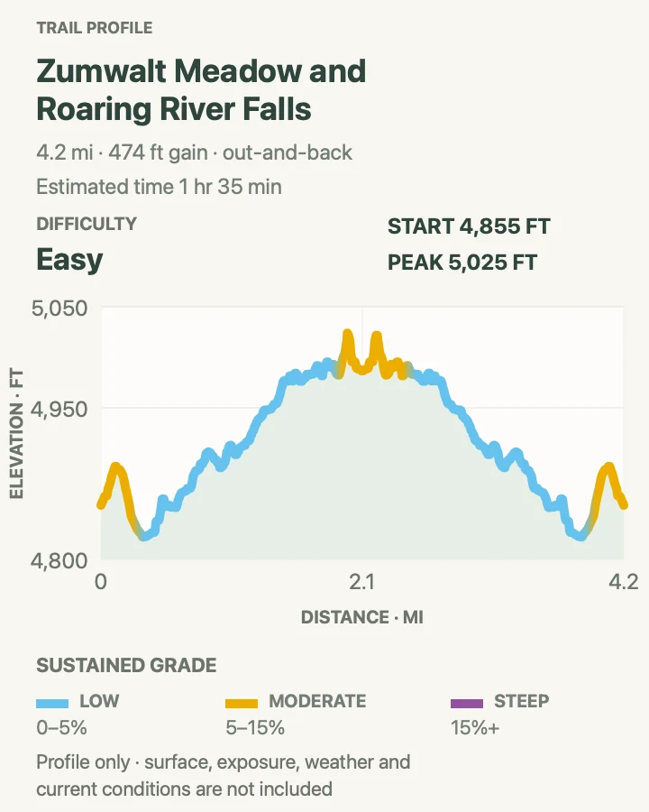
Zumwalt Meadow and Roaring River Falls
- Distance
- About 4.2 miles out and back
- Elevation gain
- 470 feet
- Time
- 1 hr 35 min
- Difficulty
- Easy
- Route type
- out-and-back
- Parking
- Use the signed Roaring River Falls and Zumwalt Meadow lots along Highway 180 in Cedar Grove.
- Best time
- Morning from late spring through autumn while Cedar Grove road is open.
- Pets
- Pets are prohibited on both trails.
This route links two Cedar Grove stops into one river-canyon walk. Roaring River Falls rushes through a granite chute near the road, while Zumwalt Meadow crosses the Kings River and follows forest and talus below immense walls.
Zumwalt is no longer a complete meadow loop because flooding removed riverside segments in 2019. Follow the open out-and-back and Kanawyer connectors instead of attempting to trace the former path through meadow or riverbank.
What helps on this route
- Stay behind barriers at Roaring River Falls; wet granite offers little grip.
- Expect sandy or flooded tread near the meadow during snowmelt.
Terrain and access: Short paved waterfall access, river bridge, forest, sandy tread, talus, meadow views, and dangerous fast water nearby.

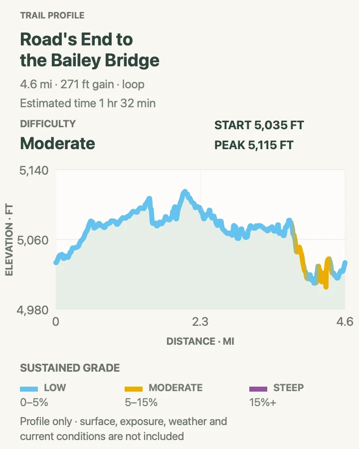
Road's End to Bailey Bridge
- Distance
- About 4.6-mile loop
- Elevation gain
- 270 feet
- Time
- 1 hr 32 min
- Difficulty
- Moderate
- Route type
- loop
- Parking
- Use the Road's End day-use lot and store all food and scented items in the provided boxes or out of sight as directed.
- Best time
- A cool morning during the Cedar Grove road season.
- Pets
- Pets are prohibited on the trail.
The route follows the broad valley beyond the end of Highway 180, crossing forest and river flats toward Bailey Bridge. It shares the opening miles used by Mist Falls and Paradise Valley hikers without requiring the full climb.
Trail junctions become consequential beyond the bridge. Keep to the planned loop, stay away from swift river edges, and leave no food in an unattended pack.
What helps on this route
- Read the Road's End trail board before walking past the permit station.
- Do not confuse Bailey Bridge with the missing South Fork bridge farther into the Rae Lakes route.
Terrain and access: Valley forest, sandy flats, river corridor, signed junctions, bridge crossing, mild grades, and bear-active trailhead.

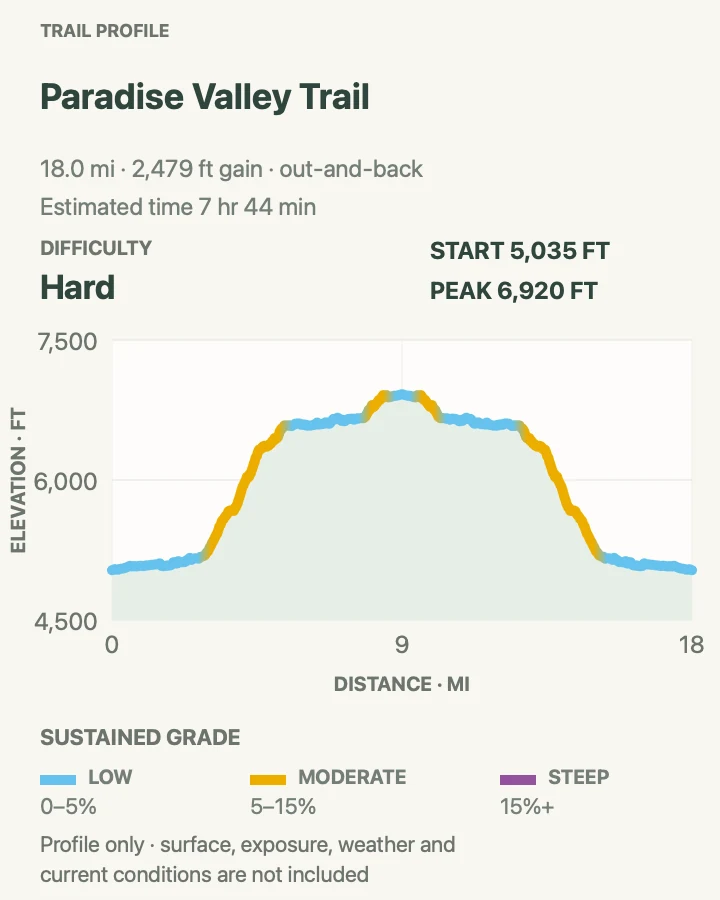
Paradise Valley Trail
- Distance
- About 18.1 miles out and back
- Elevation gain
- 2,480 feet
- Time
- 7 hr 44 min
- Difficulty
- Hard
- Route type
- out-and-back
- Parking
- Start at Road's End; obtain a wilderness permit for any overnight stay and use required food storage.
- Best time
- A long summer or early-autumn day after river crossings have eased, or as a permitted backpacking trip.
- Pets
- Pets are prohibited in the wilderness.
Paradise Valley continues beyond the Mist Falls corridor along the South Fork of the Kings River. Forest, granite walls, cascades, and open valley sections build slowly; the distance makes this a serious day even before heat or altitude enter the calculation.
The June 29, 2026 report found the route clear to Middle Paradise with a few downed trees farther on. The South Fork crossing above Paradise Valley was thigh-deep, swift, and cold, and the bridge remains washed out. The mapped day ends before that hazard. Do not continue toward Rae Lakes unless current conditions and skills support it.
What helps on this route
- Set a turnaround time based on the return mileage, not the desired campsite name.
- Carry a bear-resistant container where required and never assume a storage box will have room.
Terrain and access: Long river canyon, forest and chaparral, sandy sections, cascades, granite walls, downed-tree potential, heat, and remote wilderness travel.

Official planning sources
Trail access and safety details were checked against these National Park Service pages. The maps and profiles use the reviewed route geometry stored with this guide.
Map data © OpenStreetMap contributors. Trail geometry and planning details include National Park Service public information.