8 Best Hikes in Bryce Canyon National Park
Eight Bryce Canyon hikes from hoodoo loops to a long rim traverse, with reviewed maps, profiles, 2026 shuttle details, and live trail checks.
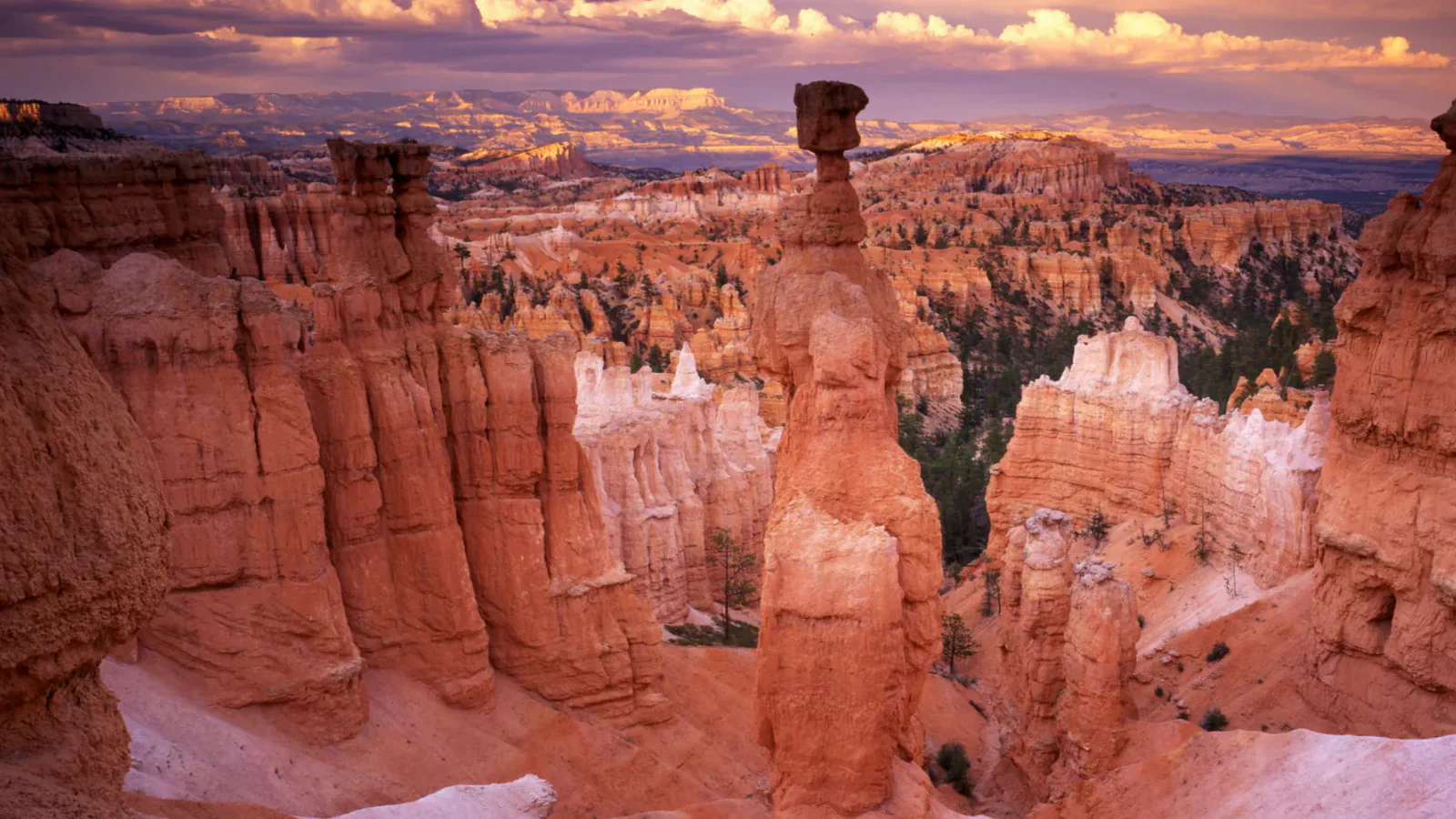
Bryce Canyon rewards hikers who leave the rim, but every descent among the hoodoos ends with a climb at roughly 8,000 feet. The short loops can feel harder than their mileage, and the long routes add exposed weather, loose slopes, and complicated transport.
These eight hikes cover different days rather than every named variation. Queen's Garden and Navajo is the first-timer's loop. The Figure 8 adds Peekaboo for a longer circuit. Tower Bridge and Hat Shop reach quieter formations, Sheep Creek and Swamp Canyon move away from the main amphitheater, and the southern rim traverse needs its own shuttle plan.
As of August 2026, Bryce is under Stage 2 fire restrictions, and summer monsoon storms can trigger washouts, debris flows, rockfall, and flash flooding. Trail closures are shown on the park's live conditions map. The free shuttle runs through October 18, but it serves the amphitheater corridor rather than Yovimpa Point.
What changes a hiking day here
Use the shuttle where it actually goes
The 2026 shuttle runs every 15 minutes from April 3 through October 18, with extended evening service through September 20. It reaches Bryce Point, Inspiration Point, Sunset Point, and Sunrise Point. It does not solve a Yovimpa Point start; that traverse requires two vehicles or an approved private ride.
Descend gently and climb steeply
For the Queen's Garden and Navajo combination, NPS recommends walking clockwise: descend Queen's Garden and climb Navajo. Most injuries occur on steep descents, and the broad hoodoo view remains in front on the way down.
Treat thunder as a turnaround signal
Summer storms arrive quickly. If thunder is audible, return to a vehicle or building. Do not enter a wash during a flood warning, and do not wait under an overhang for debris or rockfall to pass.
Know the narrow pet exception
Pets are prohibited on unpaved trails and aboard the shuttle, even when carried. Leashed pets may use the paved Rim Trail between Sunset and Sunrise points and other specified paved areas, but none of the unpaved routes below qualify.
| Trail | Distance | Time | Difficulty | Best for |
|---|---|---|---|---|
| Queen's Garden and Navajo Combination | About 3 miles | 2 hr | Moderate | A first descent among the hoodoos |
| Bryce Amphitheater Figure 8 | 6.4-mile loop | 4 hr | Hard | A full amphitheater circuit with the Wall of Windows |
| Tower Bridge Trail | About 3.8 miles out and back | 2 hr 30 min | Moderate | A quieter hoodoo walk without committing to the full Fairyland Loop |
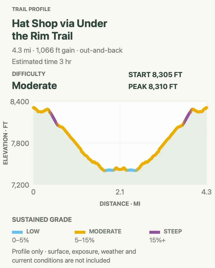
| Hat Shop via Under-the-Rim Trail | 4.3 miles out and back | 3 hr | Moderate | Balanced-rock hoodoos and a steep backcountry taste |
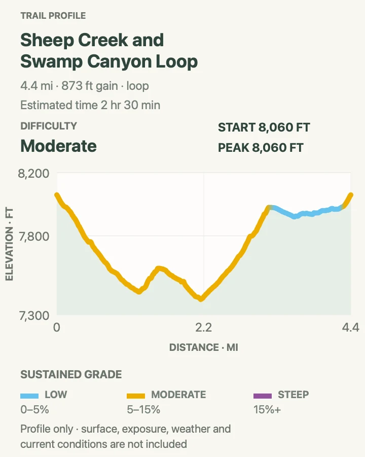
| Sheep Creek and Swamp Canyon Loop | 4.5-mile loop | 2 hr 30 min | Moderate | A quieter forest-and-canyon loop away from the main amphitheater |
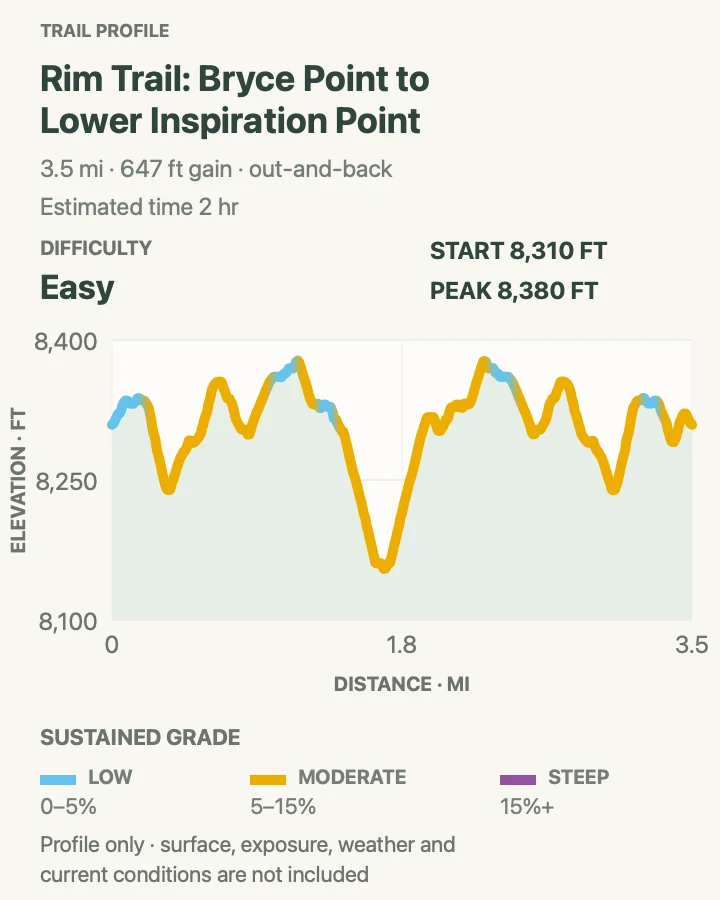
| Bryce Point to Inspiration Point Rim Walk | About 3.6 miles out and back | 2 hr | Easy | Continuous rim views without descending among hoodoos |
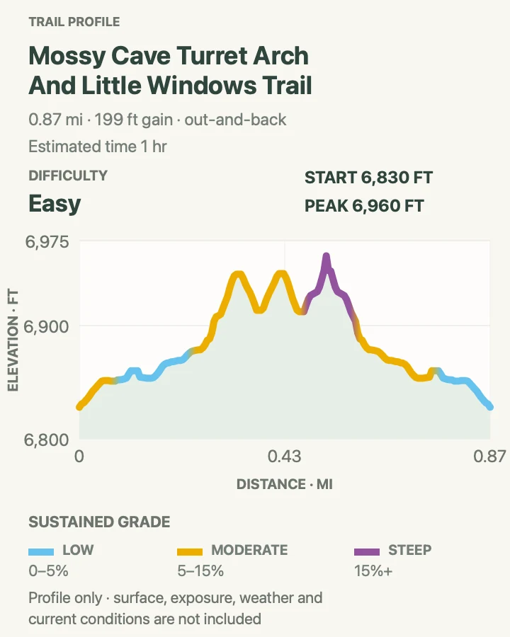
| Mossy Cave, Turret Arch, and Little Windows | About 0.9 miles out and back | 1 hr | Easy | A short family walk beside water and low hoodoos |
| Yovimpa Point to Bryce Point Rim Traverse | About 17.2 miles point to point | 9 hr 35 min | Moderate | Experienced hikers seeking a full southern-rim traverse |
Queen's Garden and Navajo Combination
- Distance
- About 3 miles
- Elevation gain
- 690 feet
- Time
- 2 hr
- Difficulty
- Moderate
- Route type
- loop
- Parking
- Park at the shuttle station or visitor center and ride to Sunrise Point; finish at Sunset Point and walk the paved half-mile rim path back.
- Best time
- Early morning before the amphitheater heats and crowds build.
- Pets
- Pets are not allowed on Queen's Garden or Navajo Loop.
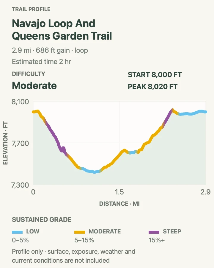
Descend Queen's Garden from Sunrise Point, pass through sculpted walls and hoodoo corridors, then climb the Navajo switchbacks to Sunset Point. The loop gains roughly 625 feet on the way out of the amphitheater.
Walk clockwise and use the Two Bridges side of Navajo whenever Wall Street is closed. Wall Street closes each winter and may close at other times after rockfall, so the live trail map determines the day's route.
What helps on this route
- Ride the shuttle instead of circling full overlook lots during operating season.
- Keep traction devices in the car when overnight freezes can leave ice in shaded switchbacks.
Terrain and access: Compacted dirt, tunnels, steep hoodoo switchbacks, loose gravel, shaded narrows, exposed rim, and about 625 feet of climbing.

Bryce Amphitheater Figure 8
- Distance
- 6.4-mile loop
- Elevation gain
- 1,660 feet
- Time
- 4 hr
- Difficulty
- Hard
- Route type
- loop
- Parking
- Use the shuttle for Sunrise or Sunset Point and begin early enough to finish before the last bus.
- Best time
- A cool, dry morning from late spring through autumn.
- Pets
- Pets are prohibited on all unpaved portions.
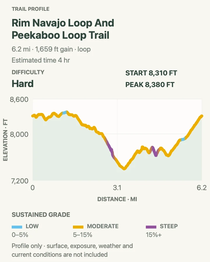
The Figure 8 links Queen's Garden, Peekaboo Loop, and Navajo Loop into one demanding circuit. It repeatedly climbs and descends through the heart of the amphitheater, reaching the Wall of Windows before the final ascent to the rim.
Travel clockwise on Peekaboo because horses and mules share the trail. Step to the safe side when stock approaches and follow the wrangler's directions. This route is a poor substitute for the shorter loop when storms or altitude are already affecting the group.
What helps on this route
- Carry at least a liter of water for every two to three hours, plus food.
- Check the last shuttle time before descending; evening service changes after September 20.
Terrain and access: Repeated hoodoo descents, steep switchbacks, horse traffic, tunnels, loose dirt, open ridges, and roughly 1,575 feet of cumulative climbing.

Tower Bridge Trail
- Distance
- About 3.8 miles out and back
- Elevation gain
- 840 feet
- Time
- 2 hr 30 min
- Difficulty
- Moderate
- Route type
- out-and-back
- Parking
- Start near Sunrise Point using the shuttle or additional parking near the visitor center.
- Best time
- Morning or late afternoon when Fairyland's exposed slopes are cooler.
- Pets
- Pets are prohibited on the trail.
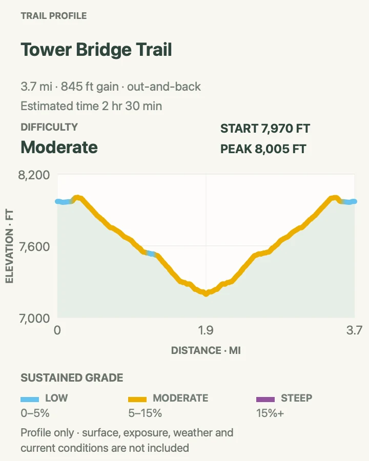
Tower Bridge uses the beginning of Fairyland Loop, descending past the Chinese Wall toward a side path and a formation resembling a stone bridge. The outward leg loses elevation, so the return is the harder half.
The reviewed route is slightly longer than the park's standard three-mile description. Follow NPS signs in the field and treat the map as route context rather than a reason to extend past the signed turnaround.
What helps on this route
- Save energy for the steady climb back to Sunrise Point.
- Continue onto Fairyland Loop only with the time, water, and map for an eight-mile day.
Terrain and access: Exposed slopes, hoodoo walls, packed dirt, loose gravel, moderate switchbacks, and a sustained return climb.

Hat Shop via Under-the-Rim Trail
- Distance
- 4.3 miles out and back
- Elevation gain
- 1,070 feet
- Time
- 3 hr
- Difficulty
- Moderate
- Route type
- out-and-back
- Parking
- Ride the park shuttle to Bryce Point or use legal parking when shuttle service is not operating.
- Best time
- A dry morning with a stable forecast and cool temperatures.
- Pets
- Pets are prohibited on the trail.
Hat Shop descends roughly 1,000 feet on the first two miles of the Under-the-Rim Trail to a group of hoodoos capped by resistant rock. The walk back to Bryce Point regains every foot.
Under-the-Rim has deteriorated sections and requires confident navigation beyond heavily used overlooks. The Hat Shop turnaround avoids an overnight itinerary, but it still calls for a map, early start, and careful footing on loose slopes.
What helps on this route
- Photograph the signed junction on the descent so the return is unmistakable.
- Do not climb onto balanced rocks or hoodoo caps.
Terrain and access: Steep forested descent, loose dirt, backcountry tread, balanced hoodoos, exposed slopes, and about 1,000 feet of return climbing.

Sheep Creek and Swamp Canyon Loop
- Distance
- 4.5-mile loop
- Elevation gain
- 870 feet
- Time
- 2 hr 30 min
- Difficulty
- Moderate
- Route type
- loop
- Parking
- Use the Swamp Canyon overlook parking area on the southern scenic drive.
- Best time
- Late spring through autumn after snowmelt, outside thunderstorm periods.
- Pets
- Pets are prohibited on the trail.
The loop drops from Swamp Canyon overlook through forest and open meadows, then uses part of the Under-the-Rim Trail before climbing back through Sheep Creek. Hoodoos appear between fir and pine rather than in one crowded bowl.
Junctions and backcountry conditions require more attention than the mileage suggests. Carry a map and ask the visitor center about washouts because repairs and cairns may lag behind recent storms.
What helps on this route
- Walk the loop only when both connecting canyon segments are confirmed open.
- Bring an extra layer; shaded southern forests stay cool even when the rim is sunny.
Terrain and access: Forest, meadows, hoodoo slopes, canyon tread, several junctions, seasonal mud or snow, and moderate climbing.

Bryce Point to Inspiration Point Rim Walk
- Distance
- About 3.6 miles out and back
- Elevation gain
- 650 feet
- Time
- 2 hr
- Difficulty
- Easy
- Route type
- out-and-back
- Parking
- Use the shuttle between Bryce Point and Inspiration Point during its operating season; verify the segment is open before starting.
- Best time
- Morning for softer light across the amphitheater, outside winter cornice closures.
- Pets
- Pets are prohibited on this unpaved rim segment and aboard the shuttle.
This section follows the rim between two of the park's strongest amphitheater viewpoints. Short climbs and exposed edges make it more active than the paved Sunset-to-Sunrise path, but it avoids the large elevation loss of canyon trails.
The segment closes in winter when snow cornices form along the cliffs. Wind and lightning also matter on the open rim. Use the shuttle for a one-way version only when service and trail access are confirmed.
What helps on this route
- Stay behind barriers and away from undercut snow even if footprints continue past a closure.
- Carry a light if planning to watch sunset from either endpoint.
Terrain and access: Unpaved rim path, rolling grades, forest patches, exposed cliff edges, wind, and seasonal snow-cornice danger.

Mossy Cave, Turret Arch, and Little Windows
- Distance
- About 0.9 miles out and back
- Elevation gain
- 200 feet
- Time
- 1 hr
- Difficulty
- Easy
- Route type
- out-and-back
- Parking
- Use the small signed lot beside SR 12 east of the main park entrance; if it is full, leave and return later rather than parking along the highway.
- Best time
- Early morning or late afternoon outside peak summer traffic.
- Pets
- Pets are prohibited on the unpaved trail.
The path follows Water Canyon to a fork for Mossy Cave and nearby hoodoo windows. The stream is an unusual sight at Bryce, but it does not make the corridor safe for wading, scrambling, or off-trail shortcuts.
Parking pressure is the main hazard. Never walk along SR 12 from an improvised shoulder space. During monsoon weather, the narrow drainage can rise quickly and carry debris.
What helps on this route
- Turn around when the lot is full and combine a later attempt with the scenic drive.
- Keep children beside you near water, drop-offs, and the highway crossing.
Terrain and access: Compacted creekside path, short grades, bridge, hoodoo walls, busy trailhead, limited parking, and flash-flood exposure.

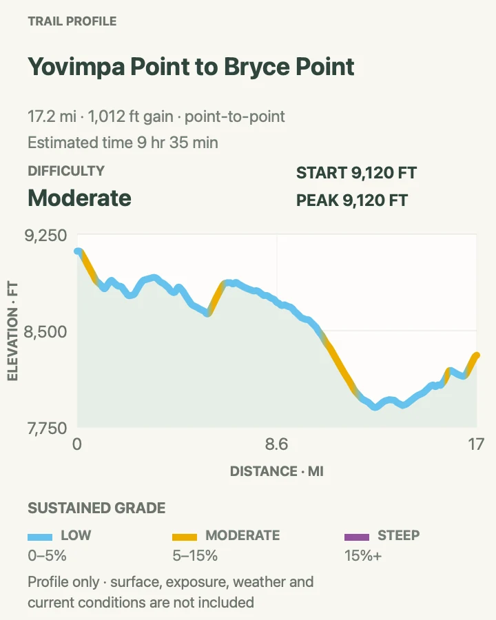
Yovimpa Point to Bryce Point Rim Traverse
- Distance
- About 17.2 miles point to point
- Elevation gain
- 1,010 feet
- Time
- 9 hr 35 min
- Difficulty
- Moderate
- Route type
- point-to-point
- Parking
- Arrange two vehicles or an approved private shuttle; the free park shuttle does not reach Yovimpa Point.
- Best time
- A long, dry summer or early-autumn day with no lightning threat.
- Pets
- Pets are prohibited on the unpaved rim and backcountry sections.
The traverse begins near Rainbow and Yovimpa points, follows the high southern rim past forest and overlooks, and finishes at Bryce Point. Though the overall direction trends north, repeated grades, altitude, weather, and distance make it a full-day undertaking.
Transport must be settled before the start. The park shuttle reaches Bryce Point but does not retrieve hikers from Yovimpa. A forecast with afternoon thunderstorms is reason to choose a shorter route because the rim offers long exposed stretches.
What helps on this route
- Confirm that every connecting segment is open on the live trail map.
- Carry a light, warm layer, topographic map, and enough food and water for delays.
Terrain and access: High-elevation forest, rolling rim trail, repeated viewpoints, exposed cliffs, long point-to-point logistics, afternoon weather, and limited bailouts.

Official planning sources
Trail access and safety details were checked against these National Park Service pages. The maps and profiles use the reviewed route geometry stored with this guide.
- NPS: Current trail conditions and fire restrictions
- NPS: Day-hike distances and combinations
- NPS: 2026 shuttle schedule
- NPS: Queen's Garden and Navajo route
- NPS: Peekaboo and Hat Shop orientation
- NPS: Winter closures and traction advice
- NPS: 2026 monsoon and rockfall safety
- NPS: Operating hours and entry information
- NPS: Bryce Canyon backcountry guide
Map data © OpenStreetMap contributors. Trail geometry and planning details include National Park Service public information.