6 Best Hikes in Hawaiʻi Volcanoes National Park
Six Hawaiʻi Volcanoes hikes across crater floor, rainforest, lava tube, petroglyph field, and Kaʻū Desert, with reviewed maps and profiles.
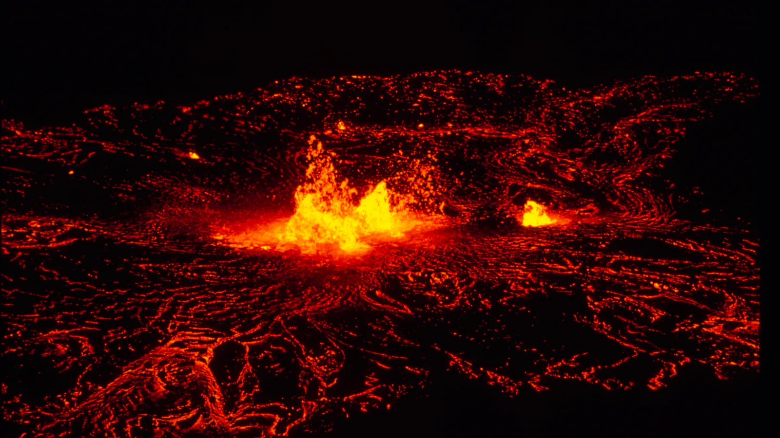
Hiking in Hawaiʻi Volcanoes can move from dripping rainforest to a hardened lava lake in one loop. Drive farther down Chain of Craters Road and the ground turns hotter, drier, and much younger. A good list has to account for those shifts instead of treating every black-rock path as the same outing.
These six routes are arranged by what they add to a trip. Kīlauea Iki is the full crater hike. Nāhuku is the short lava-tube walk. Mauna Ulu and the July 1974 flow explain two different eruptions, while Puʻuloa and the Kaʻū Desert route carry cultural history that deserves more than a quick photo stop.
Most of the park reopened on August 28, 2026 after severe storms. Kīpukapuaulu trails, Mauna Loa Road beyond the Kīpukapuaulu gate, Nāmakanipaio Campground and cabins, and the Kahuku Unit remain closed for storm damage. At the August 28 USGS update, Kīlauea was paused after episode 54 at Advisory and Yellow; the next change may arrive with little notice. Check the park and volcano reports again on the morning of the hike.
What changes a hiking day here
Read both the park alert and the volcano update
A trail can be open while gas, ash, Pele's hair, or a new closure changes the sensible plan. NPS posts visitor access, and the Hawaiian Volcano Observatory reports eruptive activity. Follow the more restrictive notice and stay behind every closure sign.
Let wind direction choose the day
Sulfur dioxide and vog can drift over trails downwind of Kīlauea, including during pauses. People with heart or breathing conditions, infants, children, and pregnant visitors should check the air-quality reading and be ready to leave.
Pack for rain and hard sun
The summit can turn wet, windy, and cool while the coastal lava fields stay hot and shadeless. Carry rain gear, sun protection, sturdy closed-toe shoes, and at least two quarts of water per person. Sharp ʻaʻā and hidden cracks punish thin soles.
Leave pets off the trail plan
Pets are prohibited on frontcountry and backcountry trails. Leashed pets have limited access to specified paved roads, parking areas, and campgrounds, but that access does not extend onto the hikes in this guide.
| Trail | Distance | Time | Difficulty | Best for |
|---|---|---|---|---|
| Kīlauea Iki and Crater Rim Trail | About 3.3-mile loop | 2 hr 8 min | Moderate | Crossing a hardened lava lake beneath rainforest walls |
| Nāhuku Lava Tube Circuit | About 0.4-mile loop from the lava-tube parking area | 10 min | Easy | A short rainforest walk through a 500-year-old lava tube |
| Mauna Ulu Eruption Trail | About 0.6-mile loop | 1 hr | Easy | A short close look at the 1969–1974 eruption field |
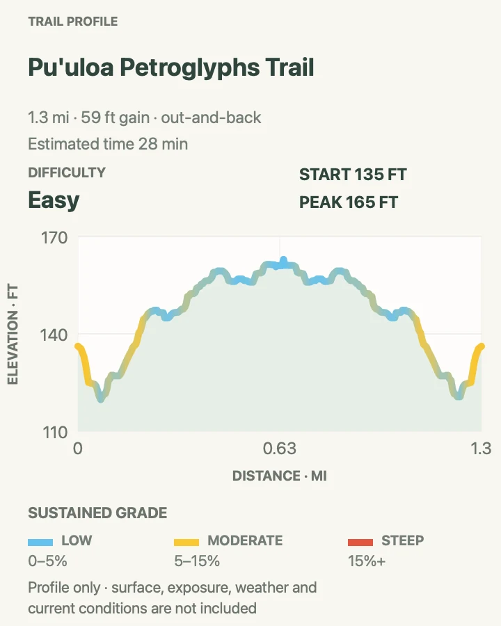
| Puʻuloa Petroglyphs Trail | About 1.4 miles out and back | 28 min | Easy | Native Hawaiian history on a young lava field |
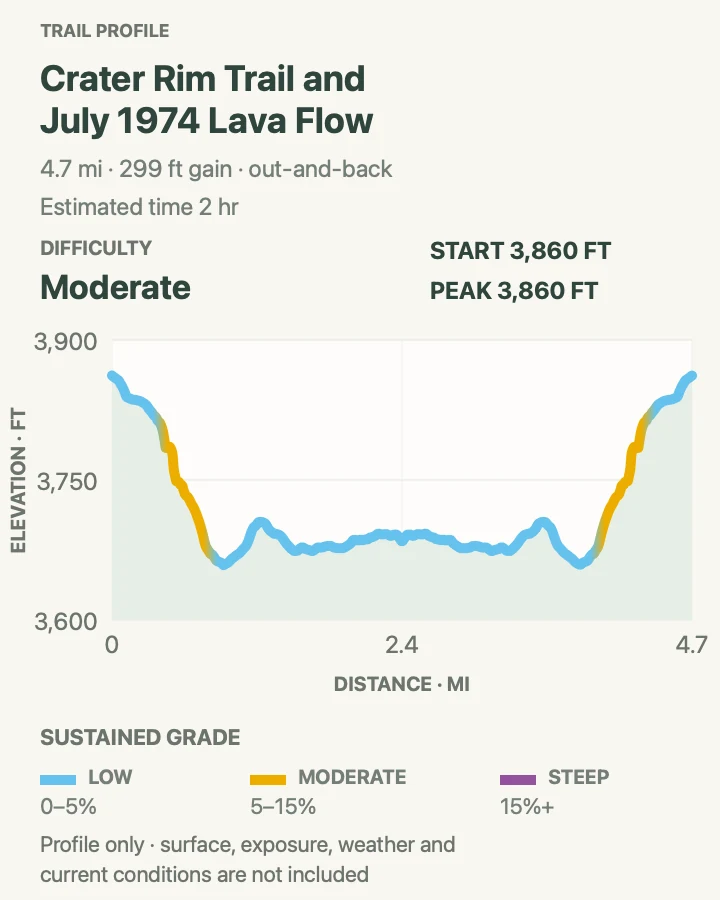
| Crater Rim Trail and July 1974 Lava Flow | About 4.7 miles out and back | 2 hr | Moderate | A longer summit walk through several eruption chapters |
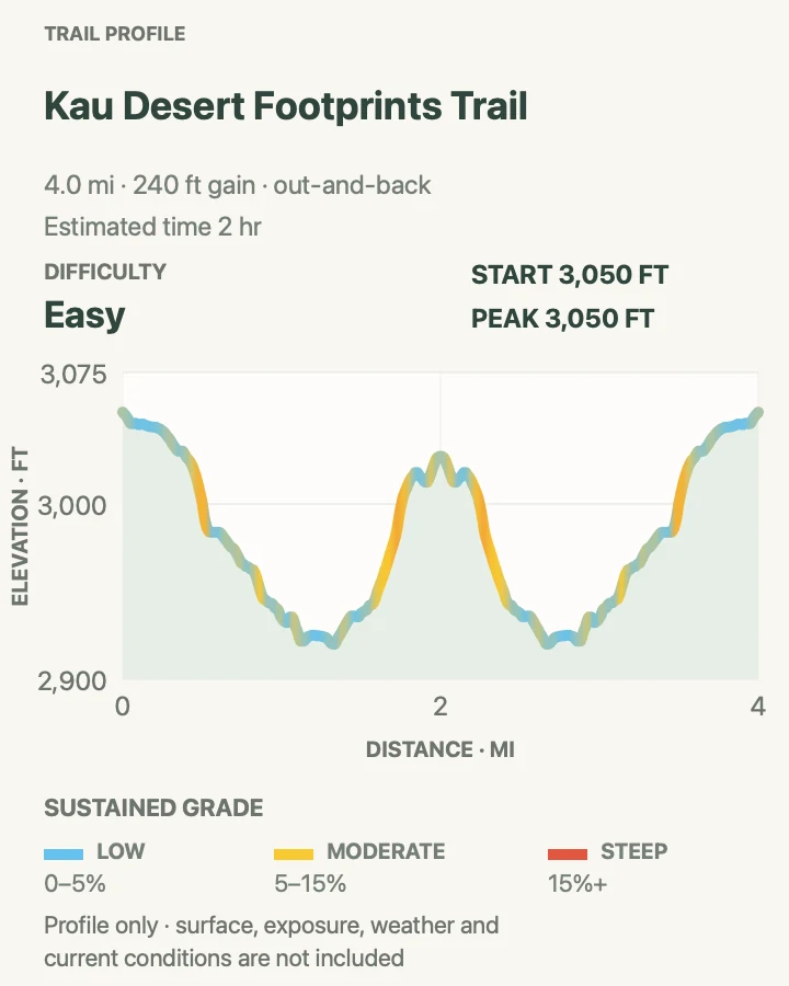
| Kaʻū Desert Footprints and Maunaiki | About 4 miles out and back | 2 hr | Easy | A quiet desert route linking the Footprints shelter and Maunaiki |
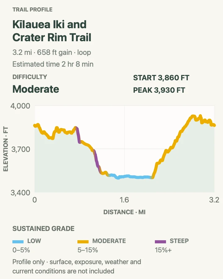
Kīlauea Iki and Crater Rim Trail
- Distance
- About 3.3-mile loop
- Elevation gain
- 660 feet
- Time
- 2 hr 8 min
- Difficulty
- Moderate
- Route type
- loop
- Parking
- Kīlauea Iki Overlook has very limited parking; start near the visitor center or at Devastation Trailhead when the overlook lot is full.
- Best time
- Early morning, before the small overlook lot fills and before clouds thicken.
- Pets
- Pets are prohibited on the trail.
The trail drops roughly 400 feet through wet forest, crosses the floor of the 1959 lava lake, and climbs back to the rim. Steam vents and fissures make the crater feel active even during a quiet period, while Puʻupuaʻi marks the vent that sent fountains high above the rim.
NPS suggests walking the loop counterclockwise from the overlook. The crater floor is exposed, and the rim can be slick after rain. Keep to the marked route; cracks and cliff edges are poor places to improvise a viewpoint.
What helps on this route
- Add Nāhuku only if parking, daylight, and weather leave enough margin.
- Carry the rain shell into the crater even when the trailhead is dry.
Terrain and access: Rainforest steps and switchbacks, rough crater floor, earth cracks, about 400 feet of descent and ascent, wet roots, exposed lava, and limited parking.

Nāhuku Lava Tube Circuit
- Distance
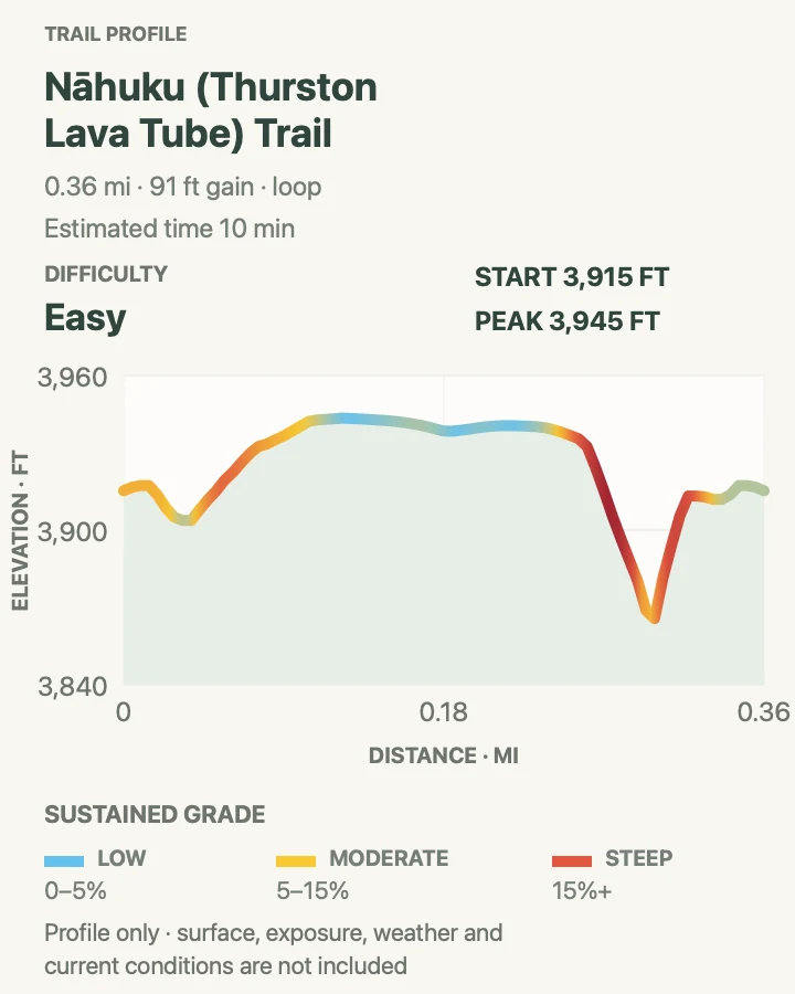
- About 0.4-mile loop from the lava-tube parking area
- Elevation gain
- 90 feet
- Time
- 10 min
- Difficulty
- Easy
- Route type
- loop
- Parking
- Use the tiny Nāhuku lot only when a legal space is open; Kīlauea Iki Overlook gives a longer 1.5-mile round trip.
- Best time
- Before 9 a.m. or after 5 p.m. for easier parking.
- Pets
- Pets are prohibited on the trail and in the lava tube.
A compact forest loop descends into Nāhuku, where a river of molten rock once left a walkable tube. A new entrance bridge opened in August 2026. Inside, low ceilings, standing water, dim corners, and uneven footing matter more than the modest mileage.
The tube is normally lit from 8 a.m. to 8 p.m. Carry a flashlight outside those hours and keep one available even when the lights should be on. Do not touch the walls or roots hanging from the ceiling.
What helps on this route
- Wait for a gap rather than passing another group in the narrowest section.
- Watch the forehead as well as the feet; several ceilings are low.
Terrain and access: Wet rainforest path, stairs, low cave ceiling, dim light, possible standing water, short steep pitches, and a paved road crossing near the parking area.

Mauna Ulu Eruption Trail
- Distance
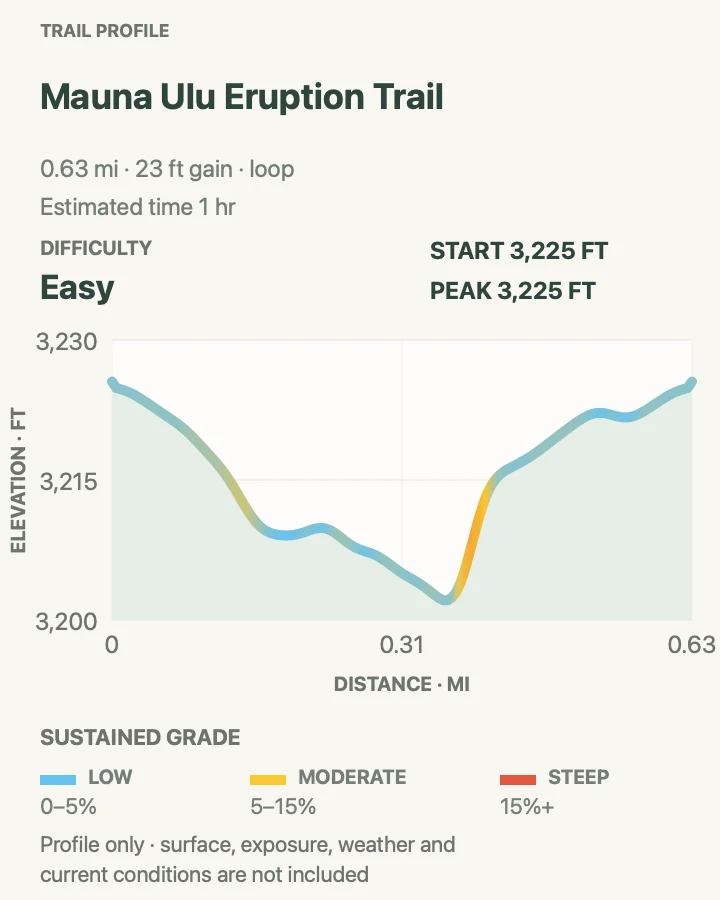
- About 0.6-mile loop
- Elevation gain
- 25 feet
- Time
- 1 hr
- Difficulty
- Easy
- Route type
- loop
- Parking
- Use the signed Mauna Ulu parking area off Chain of Craters Road.
- Best time
- Morning, before the lava surface heats up.
- Pets
- Pets are prohibited on the trail.
This short interpretive loop crosses young lava around the Mauna Ulu parking area. Lava-tree molds, ropy pāhoehoe, and seams of returning vegetation make it a useful stop for reading an eruption at walking speed.
The route in this guide is the small eruption loop, rather than the longer Nāpau Trail climb to Puʻuhuluhulu. Stay on the marked path and leave lava formations where they are; brittle edges break easily.
What helps on this route
- Pair the loop with another Chain of Craters Road stop rather than rushing it.
- Do not add a longer Nāpau segment without checking volcanic access and return time.
Terrain and access: Low-relief loop over rough pāhoehoe, lava-tree molds, exposed sun, little shade, fragile formations, and a few short moderate grades.

Puʻuloa Petroglyphs Trail
- Distance
- About 1.4 miles out and back
- Elevation gain
- 60 feet
- Time
- 28 min
- Difficulty
- Easy
- Route type
- out-and-back
- Parking
- Start at the signed Puʻuloa pullout near mile 16.5 on Chain of Craters Road.
- Best time
- Morning, when the coastal lava is cooler and clouds are less likely to build.
- Pets
- Pets are prohibited on the trail.
The trail crosses a roughly 500-year-old lava flow to a boardwalk above Puʻuloa, a sacred place with about 23,000 recorded petroglyphs. The carvings include cup-like poho tied to family practices and hopes for long life.
The low profile can disguise difficult footing. Deep cracks and sharp lava demand attention, and the boardwalk is the viewing boundary. Stepping off it can damage faint carvings that are hard to see from above.
What helps on this route
- Carry water from the car; the route has no shade or services.
- Give the boardwalk time instead of hunting for one famous image.
Terrain and access: Exposed coastal lava, jagged and uneven footing, earth cracks, no shade, boardwalk viewing area, low rolling grades, heat, and wind.

Crater Rim Trail and July 1974 Lava Flow
- Distance
- About 4.7 miles out and back
- Elevation gain
- 300 feet
- Time
- 2 hr
- Difficulty
- Moderate
- Route type
- out-and-back
- Parking
- Use an open signed summit trailhead and confirm the exact Crater Rim segment with a ranger before starting.
- Best time
- A clear morning with favorable air quality and several hours before sunset.
- Pets
- Pets are prohibited on the trail.
This extended summit route follows Crater Rim Trail toward the July 1974 flow and Keanakākoʻi area. Forest, fault cracks, old pavement, and open lava alternate across the walk, with views toward Kaluapele and the high slopes beyond when cloud permits.
Summit access can shift during construction or eruptive episodes. Use only the open marked trail and turn around at the first closure. Gas can accumulate or drift quickly, so a clear view is never a reason to ignore breathing discomfort.
What helps on this route
- Ask a ranger which summit connectors are open that morning.
- Leave the exposed lava section if ash, Pele's hair, or gas begins moving across the route.
Terrain and access: Rainforest and open caldera rim, old paved road, lava flow, earth cracks, modest rolling climb, wind, fast-changing rain, and volcanic gas exposure.

Kaʻū Desert Footprints and Maunaiki
- Distance
- About 4 miles out and back
- Elevation gain
- 240 feet
- Time
- 2 hr
- Difficulty
- Easy
- Route type
- out-and-back
- Parking
- Begin at the Kaʻū Desert Trailhead on Highway 11, outside the closed Kīpukapuaulu area.
- Best time
- Cool, dry morning with steady trade winds and good air quality.
- Pets
- Pets are prohibited on the trail.
The first 0.8 mile reaches a shelter above footprint impressions preserved in ash from the deadly 1790 eruption. Continuing to Maunaiki makes the outing about four miles round trip and leaves the short developed approach for a barer volcanic desert.
Ash and dust from the 2018 summit collapse can become airborne here. Carry eye protection and a dust mask, watch the ahu that mark the route, and expect very little shade or water. The paired dips on the profile explain why the return still asks for climbing.
What helps on this route
- Use the Footprints shelter as the turnaround for a shorter walk.
- Photograph the trailhead map before leaving Highway 11.
Terrain and access: Paved sections near the trailhead, deep sand, volcanic ash, uneven lava, low cinder rises, sparse shade, dusty wind, and ahu-marked route finding.

Official planning sources
Trail access and safety details were checked against these National Park Service pages. The maps and profiles use the reviewed route geometry stored with this guide.
- NPS: August 28 storm reopening and remaining closures
- NPS: Alerts and conditions
- USGS: Kīlauea volcano updates
- NPS: Day hikes
- NPS: Kīlauea Iki
- NPS: Nāhuku lava tube
- NPS: Maunaulu via Nāpau Trail
- NPS: Puʻuloa Petroglyphs
- NPS: Crater Rim Trail
- NPS: Footprints and Maunaiki
- NPS: Hiking and volcano safety
- NPS: Pet rules
Map data © OpenStreetMap contributors. Trail geometry and planning details include National Park Service public information.