5 Best Hikes in Isle Royale National Park
Five Isle Royale hikes from Windigo and Rock Harbor, with reviewed maps, elevation profiles, ferry logistics, and current 2026 notices.
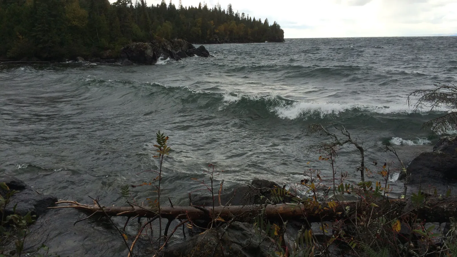
Every Isle Royale hike begins with transportation. Ferries, seaplanes, and water taxis decide where the day can start and when it must end. Rock Harbor serves the island's east end. Windigo, also called Ozaagaateng, anchors the west. There is no road between them.
These five hikes can be organized from those two portals. Grace Creek is the clear Windigo half-day. Suzy's Cave and Tobin Harbor stay close to Rock Harbor. Mount Franklin reaches the Greenstone Ridge, and the Rock Harbor-to-Daisy Farm segment makes sense with a reserved boat connection or an overnight plan.
The park's August 28, 2026 report says trails are generally dry and cleared, though downed trees remain possible. Tent, hammock, and group camping is closed at Three Mile, Daisy Farm, Moskey Basin, and Caribou Island because of wolf activity. Shelters remain open. Food and scented items now require a locker or hard-sided animal-resistant container at every campground.
What changes a hiking day here
Book transport before choosing mileage
Passenger boats and seaplanes run on fixed seasonal schedules and can be delayed by Lake Superior. Reserve both directions, then choose a hike that leaves margin for check-in and weather. A missed departure can become an unplanned night on the island.
Carry and treat water correctly
Potable water is available only at Rock Harbor and Windigo. Elsewhere, NPS recommends boiling or both filtering and chemically treating surface water. Tapeworm eggs can pass through many ordinary backpacking filters, so filtration alone is not enough.
Take the wolf closures literally
Do not pitch a tent or hammock at the four closed east-end campgrounds. Use an available shelter only where permitted, store every pack as directed, and put food, trash, toiletries, and scented gear in a locker or approved hard-sided container.
No pets travel to Isle Royale
Dogs, cats, and other mammals are prohibited on the islands and on boats within park waters. A visitor who arrives with a pet can be required to leave. Service dogs need advance paperwork from the park.
| Trail | Distance | Time | Difficulty | Best for |
|---|---|---|---|---|
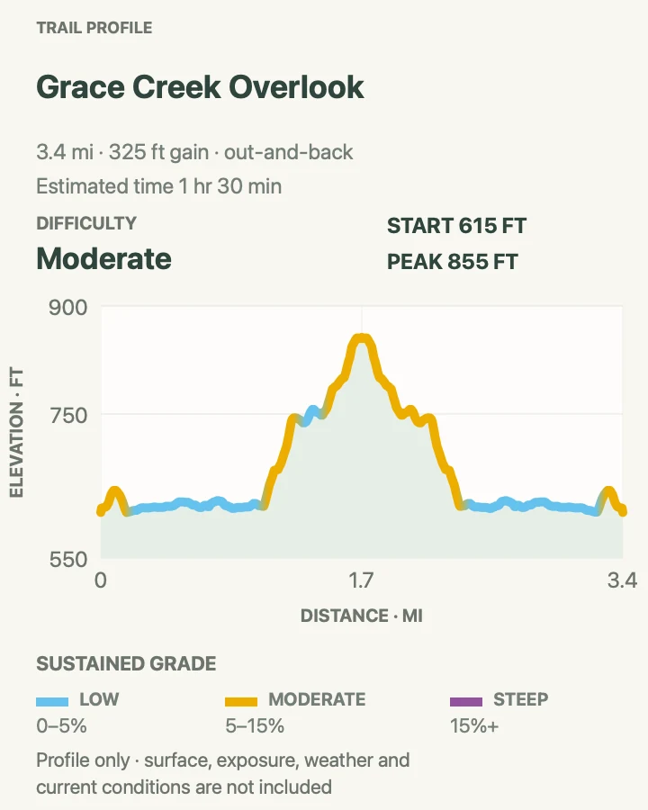
| Grace Creek Overlook | About 3.5 miles out and back | 1 hr 30 min | Moderate | A west-end ridge view without an overnight pack |
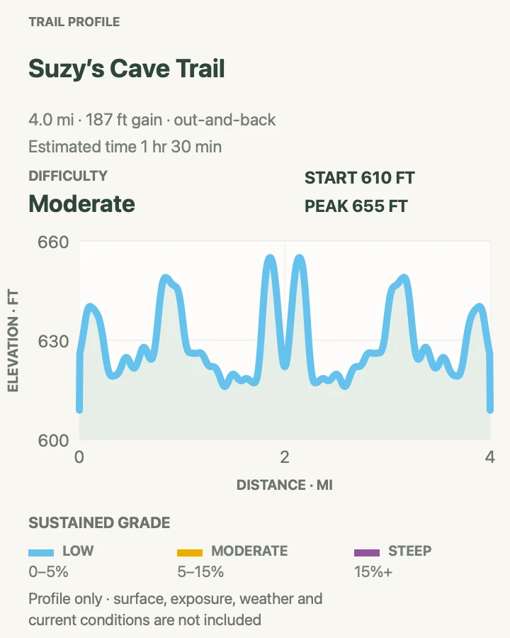
| Suzy's Cave Loop | About 4 miles | 1 hr 30 min | Moderate | An inland sea arch and two contrasting harbor trails |
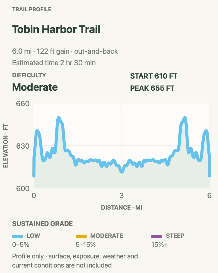
| Tobin Harbor Trail | About 6 miles out and back | 2 hr 30 min | Moderate | The smoothest longer walk from Rock Harbor |
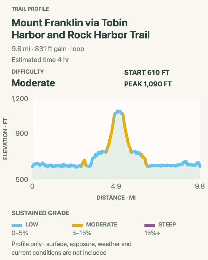
| Mount Franklin Loop | About 9.9-mile loop | 4 hr | Moderate | Greenstone Ridge views of the island and Canadian shore |
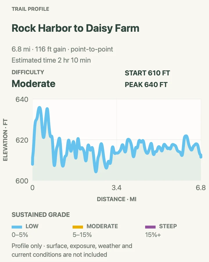
| Rock Harbor to Daisy Farm | About 6.8 miles point to point | 2 hr 10 min | Moderate | A boat-assisted section of the eastern shoreline trail |
Grace Creek Overlook
- Distance
- About 3.5 miles out and back
- Elevation gain
- 330 feet
- Time
- 1 hr 30 min
- Difficulty
- Moderate
- Route type
- out-and-back
- Parking
- Begin at Windigo and follow the Feldtmann Lake Trail toward the signed overlook spur.
- Best time
- Morning or late afternoon during the island's open season.
- Pets
- Pets are prohibited throughout Isle Royale.
The Feldtmann Lake Trail leaves Windigo through maple and birch forest, then reaches a short spur to a rocky ledge above Grace Creek. Grace Harbor and Lake Superior open to the southwest, with long forested ridges filling the middle distance.
Roots and slick rock make the modest mileage slower after rain. The ledge has no guardrail, and wildlife may appear near the creek corridor. Give moose and wolves a wide exit rather than crowding the viewpoint.
What helps on this route
- Carry water from Windigo; the creek is not a ready drinking source.
- Keep the overlook quiet so approaching hikers and wildlife have room.
Terrain and access: Forest path, roots, rocks, rolling grade, short spur, open ledge, wet footing, and a Lake Superior view.

Suzy's Cave Loop
- Distance
- About 4 miles
- Elevation gain
- 190 feet
- Time
- 1 hr 30 min
- Difficulty
- Moderate
- Route type
- out-and-back
- Parking
- Start from Rock Harbor near the visitor center and campground trail junctions.
- Best time
- A dry morning after ferry arrival or on a lodge day.
- Pets
- Pets are prohibited throughout Isle Royale.
The loop follows the rougher Rock Harbor Trail to an inland sea arch cut when Lake Superior stood higher, then returns through spruce, fir, and birch on the gentler Tobin Harbor Trail. The two halves feel different enough that the loop never becomes a simple retrace.
The cave is a geological opening, not a developed room. Do not climb loose stone around it. Watch the wooden junction posts carefully, because several longer trails leave the same Rock Harbor corridor.
What helps on this route
- Walk the rooty Rock Harbor side first while legs are fresh.
- Listen for loons along Tobin Harbor without approaching shoreline nests.
Terrain and access: Rocky shoreline trail, roots, boreal forest, inland arch, signed junction, gentler harbor return, and slippery stone after rain.

Tobin Harbor Trail
- Distance
- About 6 miles out and back
- Elevation gain
- 120 feet
- Time
- 2 hr 30 min
- Difficulty
- Moderate
- Route type
- out-and-back
- Parking
- Begin from the signed Tobin Harbor trail near Rock Harbor's developed area.
- Best time
- Early morning for cool forest and bird activity.
- Pets
- Pets are prohibited throughout Isle Royale.
Tobin Harbor Trail runs through boreal forest along the protected north side of the Rock Harbor peninsula. Its footing is generally easier than the shoreline route, and the quiet water brings frequent loon and waterfowl calls.
The Mount Franklin junction is a natural turnaround for the six-mile version. Beyond it, other trails branch toward Three Mile, Lane Cove, and the Greenstone Ridge. Carry a map even on this forgiving corridor so an interesting side trail does not become accidental mileage.
What helps on this route
- Treat only Rock Harbor tap water as potable without further treatment.
- Turn back early when a delayed ferry has shortened the day.
Terrain and access: Gentle forest trail, rocks and roots, protected harbor, several junctions, intermittent mud, and minimal sustained climbing.

Mount Franklin Loop
- Distance
- About 9.9-mile loop
- Elevation gain
- 830 feet
- Time
- 4 hr
- Difficulty
- Moderate
- Route type
- loop
- Parking
- Start at Rock Harbor and use Tobin Harbor Trail for the approach shown on the map.
- Best time
- A clear full day when the ridge forecast is stable.
- Pets
- Pets are prohibited throughout Isle Royale.
The route follows Tobin Harbor's easier tread, climbs to Mount Franklin on the Greenstone Ridge, then returns by the rockier Three Mile and Rock Harbor corridors. From the open ridge, inland lakes, the north shore, and sometimes the Canadian mainland become visible at once.
Ten Isle Royale miles contain repeated rock and root obstacles, not a smooth mainland pace. Begin with food, rain gear, and a full day's water. Heat can build on the ridge even while the harbors remain cold.
What helps on this route
- Check the current fire and trail report before committing to the ridge.
- If fog closes the view, keep to cairns and do not build new rock stacks.
Terrain and access: Boreal forest, steady ridge climb, exposed rock, roots, repeated ups and downs, shoreline return, weather swings, and long mileage.

Rock Harbor to Daisy Farm
- Distance
- About 6.8 miles point to point
- Elevation gain
- 120 feet
- Time
- 2 hr 10 min
- Difficulty
- Moderate
- Route type
- point-to-point
- Parking
- Begin at Rock Harbor or Daisy Farm only after confirming a reserved water-taxi, ferry, or overnight connection.
- Best time
- A dry morning with a generous buffer before the boat pickup.
- Pets
- Pets are prohibited throughout Isle Royale.
The Rock Harbor Trail threads the channel shore between forest, coves, and exposed basalt on its way to Daisy Farm. Small rises and rocky shelves accumulate through the day, while islands across the channel keep the water close without making the footing easy.
As of August 28, 2026, tents and hammocks are prohibited at Daisy Farm, though shelters remain open. Day hikers still need a confirmed ride or enough time to reverse the route. Do not assume a vacant shelter or an unscheduled boat will solve weak logistics.
What helps on this route
- Reconfirm the Daisy Farm dock schedule and pickup direction before leaving Rock Harbor.
- Keep food and scented items in the campground locker or an approved hard-sided container.
Terrain and access: Rocky shoreline, roots, wet ledges, forest, repeated short climbs, exposed channel views, campground junctions, and remote transport.

Official planning sources
Trail access and safety details were checked against these National Park Service pages. The maps and profiles use the reviewed route geometry stored with this guide.
- NPS: August 28, 2026 conditions and closures
- NPS: August 2026 wolf-related campsite closure
- NPS: Rock Harbor area guide
- NPS: 2026 Greenstone trip planner
- NPS: Grace Creek Overlook hike
- NPS: Suzy's Cave hike
- NPS: Tobin Harbor Trail
- NPS: Three Mile to Daisy Farm trail segment
- NPS: Drinking water treatment
- NPS: Pet restrictions
Map data © OpenStreetMap contributors. Trail geometry and planning details include National Park Service public information.