6 Best Hikes in Indiana Dunes National Park
Six Indiana Dunes hikes through beach, dune, bog, oak woodland, riverfront, and rail-side corridors, with reviewed maps, profiles, and live park alerts.
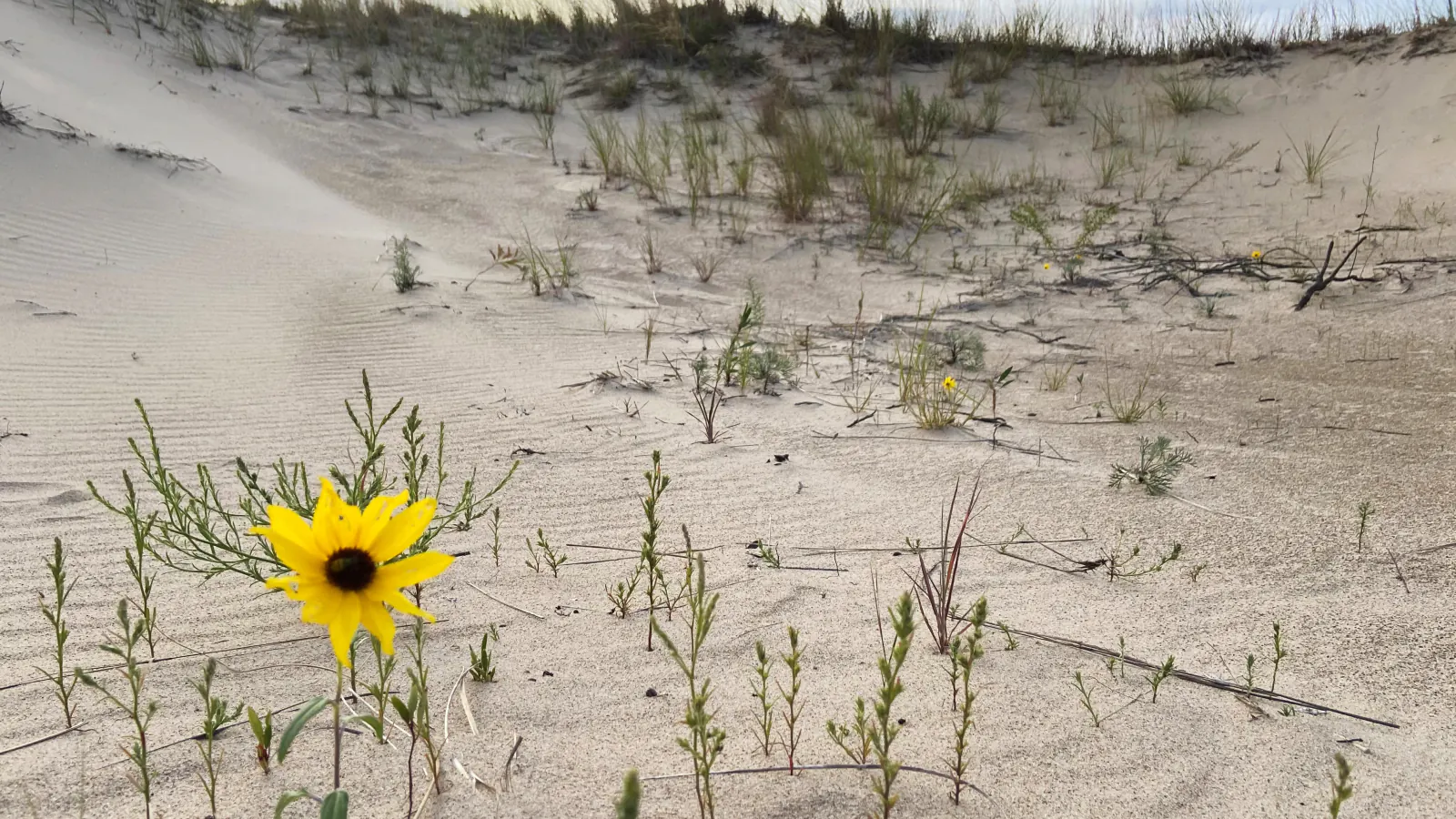
Indiana Dunes stretches through a narrow, fragmented band of Lake Michigan shore, wetlands, woodland, prairie, and former industrial ground. The trailheads are not arranged around one park road. Choosing the right unit matters as much as choosing the distance.
These six routes avoid counting every paved connector as a separate hike. Dune Succession explains how bare beach becomes oak woodland; Cowles Bog adds wetland and steep sand; Pinhook stays inland; Portage shows a reclaimed industrial shore. Marquette and Calumet provide longer, flatter mileage across the western and central units.
As of August 2026, part of the Portage Lakefront and Riverwalk beside Burns Waterway is closed because of erosion damage. Other temporary construction closures are marked on the park's closure map. Check that page, the beach forecast, E. coli monitoring, and wave warnings before leaving home.
What changes a hiking day here
Match the map to the trailhead name
Park units sit among towns, rail lines, highways, industry, and state-park land. Download the official area map and confirm the parking entrance before driving; a nearby beach name may use a different access road.
Treat Lake Michigan like open water
Rip currents, high waves, cold water, uneven bottom, and bacteria advisories can make swimming unsafe. Hiking to a beach does not make entering the water part of the route. Stay off shelf ice in winter.
Keep off dune shortcuts
Loose sand is slow, and climbing outside marked paths erodes plants that hold the dune together. Boardwalks and stairs are part of the route; remain on them even when a direct line looks shorter.
Check for ticks after every inland walk
Ticks can be active whenever temperatures rise above 40 degrees Fahrenheit. Walk in the center of the trail, use repellent, inspect clothing and pets, and shower soon after hiking.
| Trail | Distance | Time | Difficulty | Best for |
|---|---|---|---|---|
| Dune Succession and West Beach Circuit | Up to 3.4 miles | 1 hr 30 min | Moderate | Dune ecology, stairs, lake views, and several loop lengths |
| Portage Lakefront and Riverwalk | 2 mi | 1 hr | Easy | Accessible lake views and a reclaimed industrial shoreline |
| Cowles Bog Trail | 4.4 mi | 1 hr 28 min | Moderate | Wetland, savanna, steep dunes, and a quieter beach |
| Pinhook Bog Upland Trail | 2.1 mi | 1 hr | Easy | A quiet inland forest loop beside a protected bog |
| Marquette Trail | 4.6 mi | 2 hr | Moderate | Longer, flatter mileage through the western units |
| Calumet Trail | 9.2 mi | 3 hr | Easy | A long, flat point-to-point walk across the central dunes corridor |
Dune Succession and West Beach Circuit
- Distance
- Up to 3.4 miles
- Elevation gain
- 370 feet
- Time
- 1 hr 30 min
- Difficulty
- Moderate
- Route type
- loop
- Parking
- Use the West Beach visitor parking area; seasonal entrance fees and busy-summer controls may apply.
- Best time
- Morning in spring or fall, or a calm summer day before beach crowds arrive.
- Pets
- Leashed pets are allowed on trails, but not in the West Beach lifeguarded swimming area from Memorial Day weekend through Labor Day.
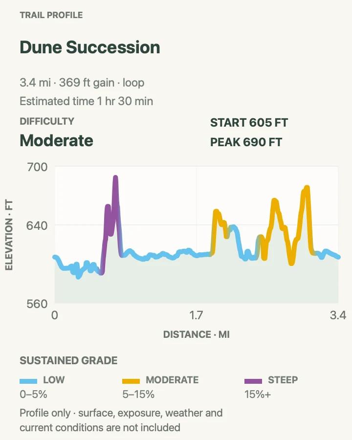
The core Dune Succession Trail is a one-mile loop through beach, foredune, shrub, and oak-covered dune communities. The reviewed circuit links it with longer West Beach paths to reach roughly 3.4 miles, giving hikers a fuller walk while preserving the short option.
Expect sand and a long staircase rather than a flat beach stroll. Stay on the built route through fragile plants, and check wave conditions before treating the shoreline as a rest stop.
What helps on this route
- Choose the one-mile loop if stairs, heat, or beach traffic make the longer circuit unattractive.
- Read the ecology stops in order; the route is designed to show change from shore to forest.
Terrain and access: Beach sand, boardwalk, long stairs, open dunes, shrub and oak woodland, marked loop junctions, and exposed Lake Michigan weather.

Portage Lakefront and Riverwalk
- Distance
- 2 mi
- Elevation gain
- 80 feet
- Time
- 1 hr
- Difficulty
- Easy
- Route type
- loop
- Parking
- Use the signed north or south parking area at Portage Lakefront, open daily from sunrise to dusk.
- Best time
- Early morning for birds and quiet water, or a clear evening outside high-wave conditions.
- Pets
- Leashed pets are permitted outdoors; keep them away from wildlife and carry out waste.
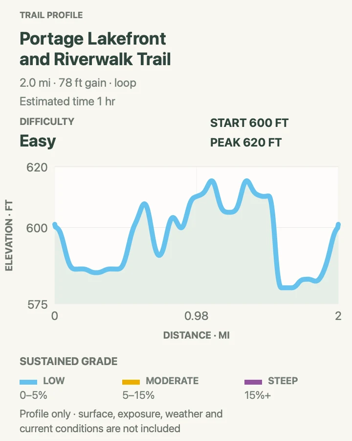
Portage transformed former settling ponds and sewage-treatment ground into a public lakefront with dune plantings, an accessible pier, pavilion, and paths beside Burns Waterway. The full mapped loop is about two miles when every section is open.
A portion along Burns Waterway is currently closed because erosion made it unsafe. Obey barriers and use the open lakefront paths as an out-and-back until NPS removes the notice. The breakwater and water edges can also be dangerous during high waves.
What helps on this route
- Check the live trail page for the erosion closure before assuming a loop.
- Use the north approach for the gentler path; the south lot connects by stairs.
Terrain and access: Paved and hardened paths, accessible pier, lake and waterway edges, stairs from one lot, reclaimed dunes, wind, and a current partial closure.

Cowles Bog Trail
- Distance
- 4.4 mi
- Elevation gain
- 390 feet
- Time
- 1 hr 28 min
- Difficulty
- Moderate
- Route type
- loop
- Parking
- Use the Cowles Bog trailhead on Mineral Springs Road and remain in marked parking.
- Best time
- Spring wildflowers, autumn color, or a cool summer morning before the sand heats.
- Pets
- Leashed pets are allowed; ticks, poison ivy, hot sand, and steep loose slopes require close control.
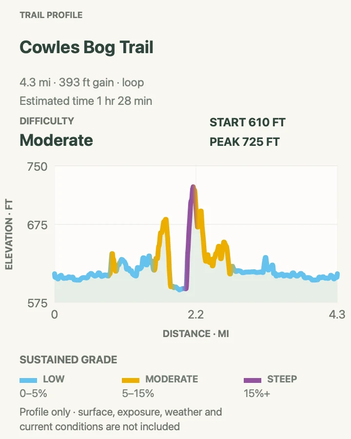
Cowles Bog crosses wetland margins and woodland before climbing steep dunes to Lake Michigan. The route helped establish the dunes as the birthplace of American ecology, yet the modern loop feels strenuous because soft sand concentrates near the lakeward ridges.
Water levels and mud alter the low sections. Stay on boardwalk or marked tread, then save energy for the return climb from the beach. Rail and industrial sounds are part of this protected urban shore.
What helps on this route
- Carry enough water for the sandy return instead of relying on the beach as the finish.
- Do a tick check after the wetland and woodland portions.
Terrain and access: Wetland edge, boardwalk, forest, savanna, steep loose dunes, beach, roots, mud, and repeated short climbs.

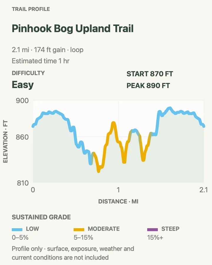
Pinhook Bog Upland Trail
- Distance
- 2.1 mi
- Elevation gain
- 170 feet
- Time
- 1 hr
- Difficulty
- Easy
- Route type
- loop
- Parking
- Use the Pinhook Bog parking area and follow signs specifically for the upland loop.
- Best time
- Spring through fall during daylight, checking seasonal hours and any ranger-program restrictions.
- Pets
- Leashed pets are allowed on the Upland Trail but not on the separate Pinhook Bog Trail or boardwalk.
The upland loop circles forest above the bog basin, passing glacial terrain and mature trees without entering the sensitive floating mat. It provides a wooded counterpoint to the park's beach and dune routes.
Do not confuse this open upland trail with the bog boardwalk, where access and pet rules differ. Gates, program schedules, and wet conditions can affect the site, so confirm current access before making the drive east.
What helps on this route
- Read every trailhead sign before bringing a dog beyond the parking area.
- Use insect repellent and expect wet, rooted tread after rain.
Terrain and access: Inland hardwood forest, glacial uplands, roots, seasonal mud, gentle hills, protected bog boundary, and separate access rules nearby.

Marquette Trail
- Distance
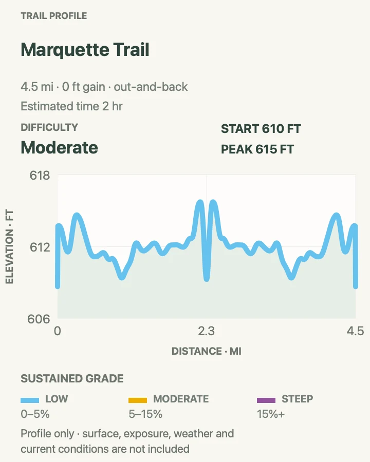
- 4.6 mi
- Elevation gain
- 0 feet
- Time
- 2 hr
- Difficulty
- Moderate
- Route type
- out-and-back
- Parking
- Choose an official access point in the western park corridor and verify that the vehicle will not be locked behind a seasonal gate.
- Best time
- Cool daylight hours in spring or fall, or winter when the surface is clear of ice.
- Pets
- Leashed pets are permitted; keep them clear of cyclists and road crossings.
Marquette provides a mostly level out-and-back across the park's western mosaic of woods, open ground, roads, and restored land. It suits hikers who want steady mileage without repeated dune climbs.
This is an urban corridor rather than an isolated forest path. Cross roads carefully, yield on shared sections, and keep the return endpoint clear because several nearby greenways carry similar names.
What helps on this route
- Mark the exact parking access in an offline map before beginning.
- Wear visible clothing near road and rail crossings.
Terrain and access: Mostly flat multi-use corridor, woodland and open sections, road crossings, urban edges, compact surface, and limited elevation change.

Calumet Trail
- Distance
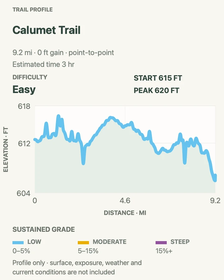
- 9.2 mi
- Elevation gain
- 0 feet
- Time
- 3 hr
- Difficulty
- Easy
- Route type
- point-to-point
- Parking
- Arrange a legal endpoint or shuttle before attempting the full point-to-point route; do not leave a car on private or rail property.
- Best time
- Dry spring or fall weather, avoiding saturated tread and summer heat.
- Pets
- Leashed pets are allowed, but nine miles of exposed corridor and crossings require water and paw checks.
Calumet Trail runs roughly nine miles parallel to the South Shore rail corridor and connects several central park areas. Its flat profile hides the logistical problem: this is a point-to-point route with wet stretches, road crossings, and no automatic ride back.
Drainage can leave the surface muddy or flooded after rain. Check current conditions, arrange both ends, and turn the route into a shorter out-and-back if transport is uncertain. Stay outside rail right-of-way at all times.
What helps on this route
- Use it as a bike or walking corridor only where current signs allow that mode.
- Carry high-visibility clothing and an offline map for the road crossings.
Terrain and access: Long flat corridor, compacted and wet tread, rail and road proximity, drainage problems, open sun, sparse facilities, and point-to-point logistics.

Official planning sources
Trail access and safety details were checked against these National Park Service pages. The maps and profiles use the reviewed route geometry stored with this guide.
Map data © OpenStreetMap contributors. Trail geometry and planning details include National Park Service public information.