7 Best Hikes in Hot Springs National Park
Seven Hot Springs hikes from Bathhouse Row to West Mountain, North Mountain, and Gulpha Gorge, with reviewed maps, profiles, pet rules, and live park alerts.
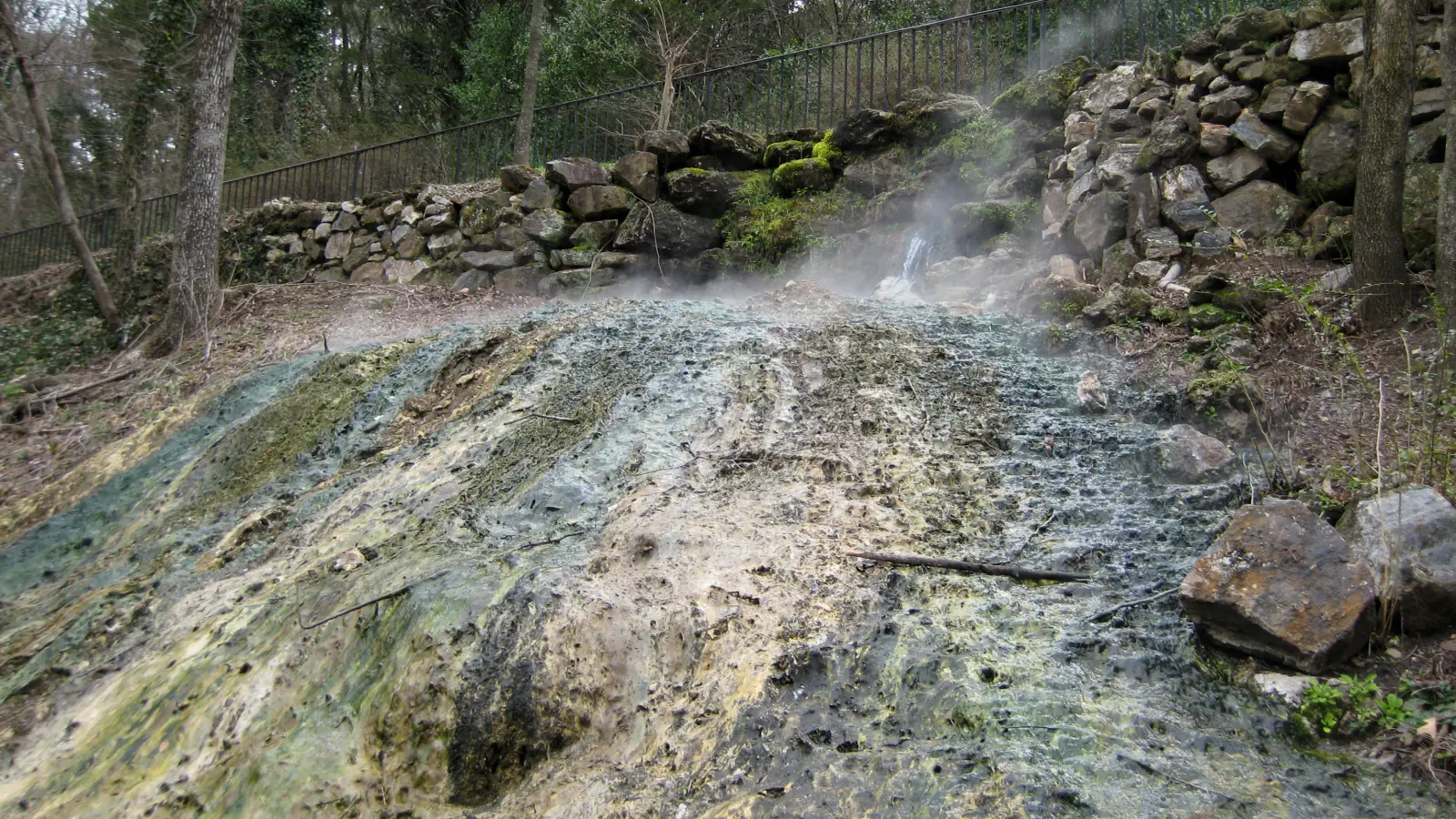
Hot Springs is an urban national park with a real mountain trail system behind the bathhouses. A morning can start on brick paving above Central Avenue, climb into oak and pine forest, cross a ridge, and finish beside thermal-water fountains downtown.
These seven routes use the trail networks that make the park distinct. Grand Promenade is the historic walk. Honeysuckle and Lower Dogwood are short woodland loops. Two West Mountain options provide different ways to gain the ridge, while the Gulpha Gorge loop joins campground, creek, and Hot Springs Mountain in one compact circuit.
Summer days are hot and humid, with frequent lightning and heavy rain. The thermal water emerges hot enough to burn, and it should be handled only at approved fountains or bathhouses. Check the live NPS alert, carry ordinary drinking water on every trail, and return to the trailhead when thunder begins.
What changes a hiking day here
Choose a trailhead before searching for parking
Bathhouse Row walkers often use downtown street spaces or the Exchange Street garage. West Mountain and Hot Springs Mountain have separate pullouts, while Gulpha Gorge routes begin at the campground amphitheater. Do not assume one lot serves the whole network.
Leave the ridge when thunder starts
Spring and summer storms can form quickly, and no outdoor place is safe during lightning. Descend from exposed ridges, return to the car, and avoid creek crossings during heavy rain.
Carry cool water, not collected hot water
Thermal water is available at approved fountains, but it may be too hot to drink immediately and requires a heat-safe container. Fill a normal hiking bottle with cool water before climbing.
Use trail names at every junction
The compact mountain networks intersect repeatedly. Photograph the NPS map, read each sign, and resist unmarked spurs that leave the park or approach private property.
| Trail | Distance | Time | Difficulty | Best for |
|---|---|---|---|---|
| Grand Promenade | 0.7 mi | 1 hr | Easy | Historic Bathhouse Row views and an easy introduction |
| Honeysuckle and Peak Trail Loop | 1.3 mi | 1 hr | Moderate | A short forest climb from downtown |
| Lower Dogwood Trail | 1.6 mi | 1 hr | Easy | An easy woodland loop away from Bathhouse Row traffic |
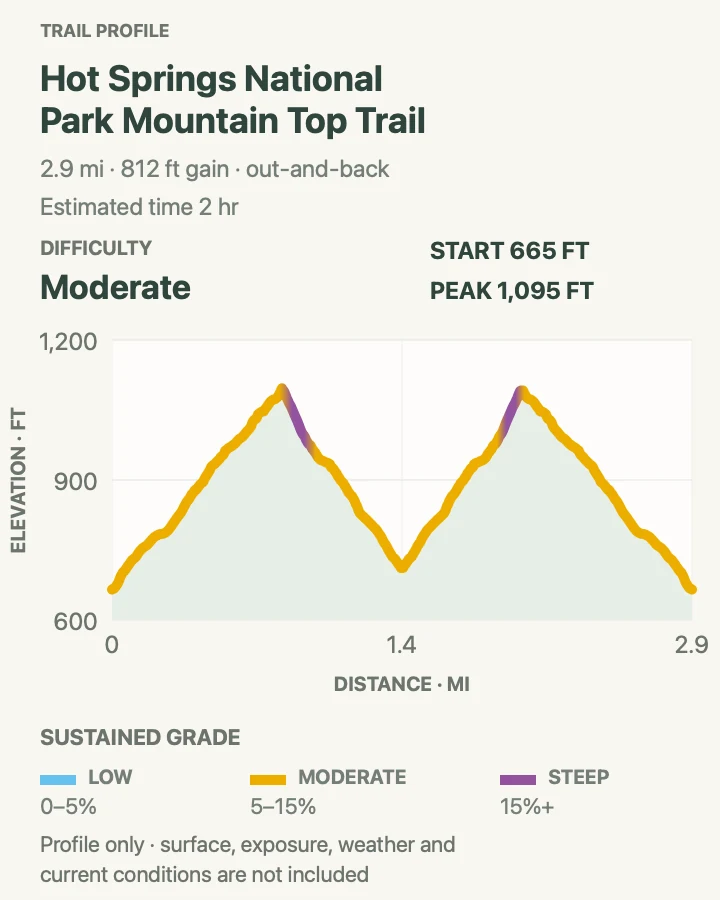
| West Mountain Top Trail | 2.9 mi | 2 hr | Moderate | A steady climb across West Mountain |
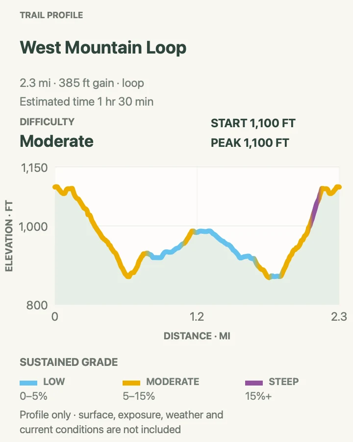
| West Mountain Loop | 2.3 mi | 1 hr 30 min | Moderate | A compact ridge circuit with city and Lake Hamilton views |
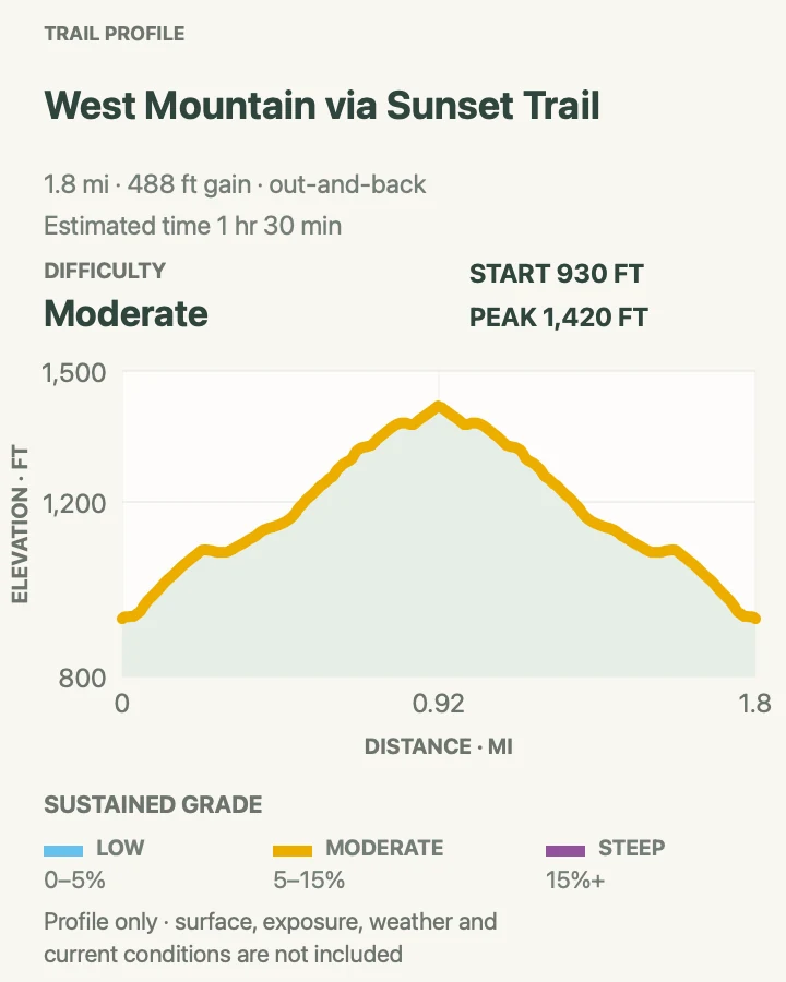
| West Mountain via Sunset Trail | 1.9 mi | 1 hr 30 min | Moderate | A short sample of the park's longest trail |
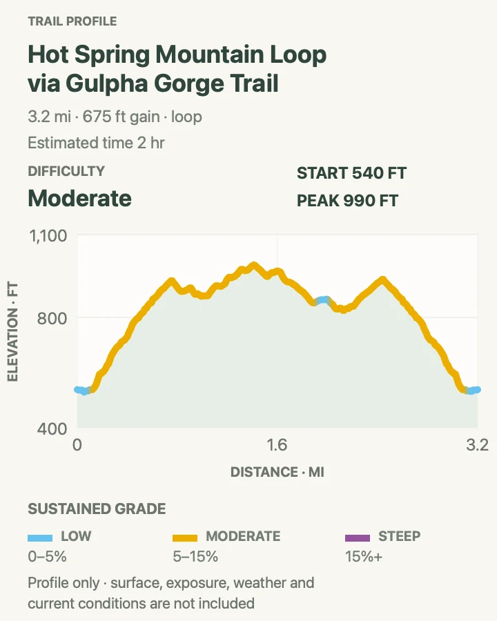
| Hot Springs Mountain Loop via Gulpha Gorge | 3.3 mi | 2 hr | Moderate | Creek, campground, gorge climb, and mountain forest in one loop |
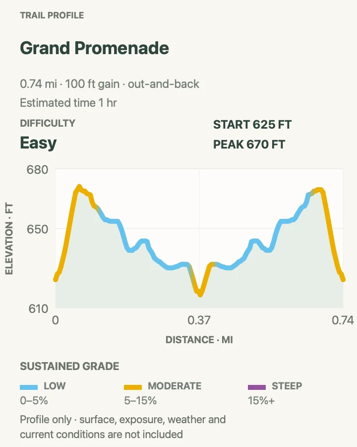
Grand Promenade
- Distance
- 0.7 mi
- Elevation gain
- 100 feet
- Time
- 1 hr
- Difficulty
- Easy
- Route type
- out-and-back
- Parking
- Use downtown street parking or the Exchange Street garage, then reach the brick path by stairs or ramp behind Bathhouse Row.
- Best time
- Early morning, evening, or before a bathhouse visit in any season.
- Pets
- Leashed pets are welcome outdoors and on all park trails; the leash may not exceed six feet, and pets cannot enter federal buildings.
The Grand Promenade runs above Bathhouse Row on a broad brick path, passing formal plantings, spring displays, and connections to Peak and Oertel trails. Its elevation above Central Avenue gives a better view of the historic buildings than the sidewalk below.
The path is short enough to repeat in both directions, but the ramps and staircases change the effort. Heat reflects from brick during summer. Walk early, then return by the opposite access to see a different section of the row.
What helps on this route
- Use the ramp near the hot water cascade for a gentler connection than the main stairs.
- Pair the walk with the Fordyce Bathhouse visitor center when it is open.
Terrain and access: Brick promenade, ramps and optional stairs, urban shade, benches, spring displays, downtown access, and short moderate grades.

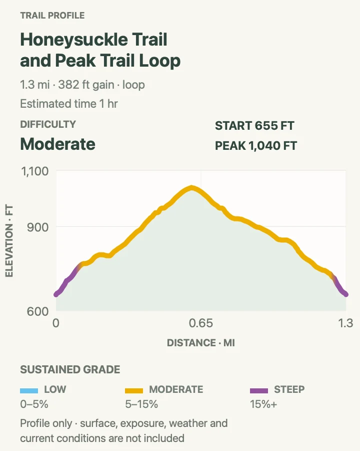
Honeysuckle and Peak Trail Loop
- Distance
- 1.3 mi
- Elevation gain
- 380 feet
- Time
- 1 hr
- Difficulty
- Moderate
- Route type
- loop
- Parking
- Start behind Bathhouse Row from the Grand Promenade or use authorized parking near Hot Springs Mountain Tower.
- Best time
- Cool morning or late afternoon outside stormy weather.
- Pets
- Leashed pets are permitted; carry water and keep paws off hot pavement before and after the dirt trail.
Peak Trail climbs directly from the Grand Promenade toward Hot Springs Mountain, then Honeysuckle bends through forest to form a short circuit. The wooded setting arrives quickly despite the buildings and streets below.
A mile and a third includes enough climbing to feel like a hike. Roots, leaf cover, and short steep pieces can be slick after rain. Take the signed loop rather than following maintenance tracks toward the tower road.
What helps on this route
- Climb Peak Trail first if you prefer to finish on the gentler Honeysuckle side.
- Add the tower only after checking the concession's current operating hours.
Terrain and access: Wooded dirt trail, roots, leaf litter, short steep grades, several junctions, road proximity, and downtown-to-ridge climbing.

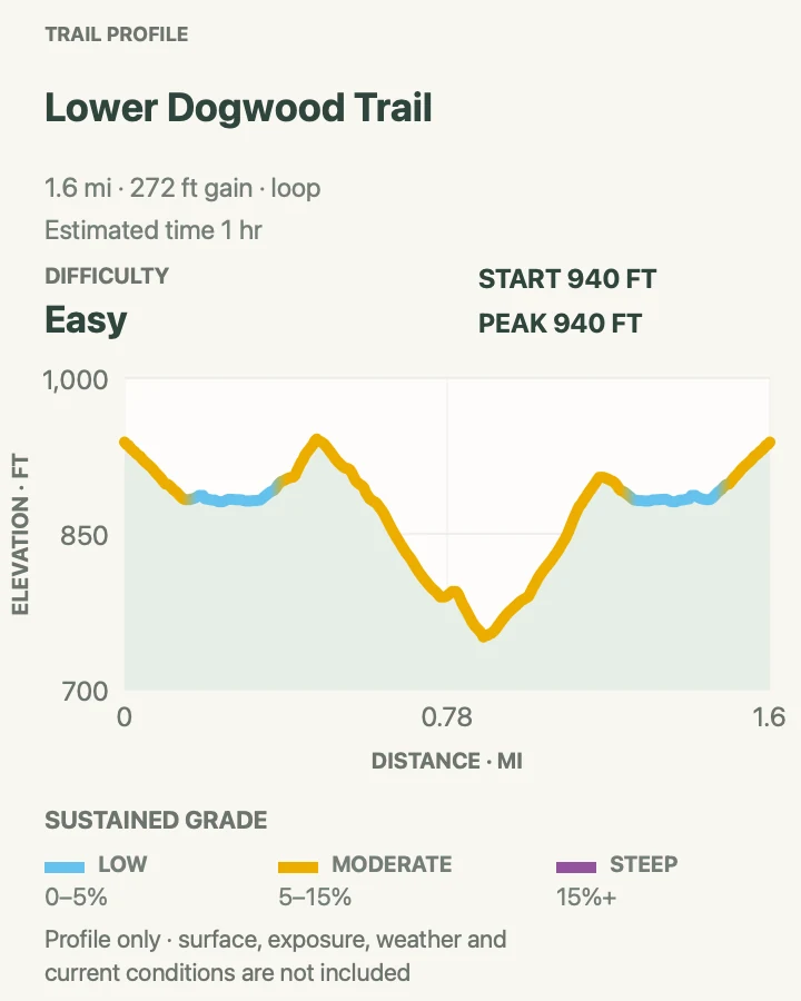
Lower Dogwood Trail
- Distance
- 1.6 mi
- Elevation gain
- 270 feet
- Time
- 1 hr
- Difficulty
- Easy
- Route type
- loop
- Parking
- Use a signed Hot Springs Mountain or North Mountain pullout that connects with the Lower Dogwood network.
- Best time
- Spring flowering season, autumn color, or a cool winter afternoon.
- Pets
- Leashed pets are welcome; watch for ticks, chiggers, snakes, and hot surfaces in summer.
Lower Dogwood circles through hardwood forest on the eastern side of the mountain system. It is a modest loop with enough separation from downtown to hear birds and wind rather than Central Avenue.
The easy rating does not mean smooth paving. Leaves can hide rocks, roots, and wet spots, and side trails connect to longer North Mountain routes. Match junction names to the map before turning.
What helps on this route
- Use insect repellent and check clothing for ticks after the walk.
- Avoid the loop in strong wind because falling limbs are a forest hazard.
Terrain and access: Hardwood forest, dirt tread, roots, leaf litter, gentle rolling grade, connecting trails, and seasonal insects.

West Mountain Top Trail
- Distance
- 2.9 mi
- Elevation gain
- 810 feet
- Time
- 2 hr
- Difficulty
- Moderate
- Route type
- out-and-back
- Parking
- Use a signed West Mountain pullout or begin from Whittington Park for the mapped out-and-back.
- Best time
- A clear spring or fall morning, or winter when leaves open wider views.
- Pets
- Leashed pets are permitted on the trail; bring enough water for both hiker and animal.
Mountain Top Trail crosses the upper part of West Mountain and connects the summit road with lower trailheads. Direction matters: southbound travel climbs more sharply, while the northward line rises steadily before descending toward Whittington Park.
The mapped out-and-back gives a moderate ridge workout without committing to the distant Sunset network. Road crossings and several connectors require attention. Use designated crosswalks and stay on the marked tread.
What helps on this route
- Choose the starting end based on whether you want the steepest grade early or late.
- Do not park outside a signed space on the narrow mountain road.
Terrain and access: Forested ridge, sustained moderate grades, a few steep pieces, road crossings, rocky tread, leaf cover, and West Mountain junctions.

West Mountain Loop
- Distance
- 2.3 mi
- Elevation gain
- 390 feet
- Time
- 1 hr 30 min
- Difficulty
- Moderate
- Route type
- loop
- Parking
- Start from a signed West Mountain trail pullout or an established connection near Whittington Park.
- Best time
- Morning in warm months or midday in cool, calm winter weather.
- Pets
- Leashed pets are welcome on the full loop; pack out all waste.
The loop joins upper West Mountain tread with a lower return, passing forest, road viewpoints, and glimpses toward the city and Lake Hamilton. It is a fuller circuit than the short Mountain Top out-and-back without adding an all-day distance.
Several official trails occupy this small ridge. Follow signs rather than every visible spur, and remain north of the communication towers where NPS directs Sunset users away from restricted ground.
What helps on this route
- Photograph the West Mountain map because loop names change at junctions.
- Winter leaf-off views can compensate for cooler, windier conditions.
Terrain and access: Mixed hardwood forest, ridge and side-slope tread, loose rock, moderate climbing, road and tower proximity, and several signed junctions.

West Mountain via Sunset Trail
- Distance
- 1.9 mi
- Elevation gain
- 490 feet
- Time
- 1 hr 30 min
- Difficulty
- Moderate
- Route type
- out-and-back
- Parking
- Use West Mountain Summit parking or the approved trailhead at the opposite end of the selected segment.
- Best time
- A cool clear day, avoiding wet leaves and lightning.
- Pets
- Leashed pets are permitted, but summer heat and humidity demand extra water and an early start.
This out-and-back samples the West Mountain section of Sunset Trail rather than pretending to complete the full route. It follows an orange-blazed ridge corridor with views south across the park and toward Lake Hamilton.
Sunset continues far beyond this map. False trails can leave the park and reach private property, so turn at the recorded endpoint and follow orange blazes on the return. Remain north of the communication towers.
What helps on this route
- Use this segment to decide whether a separate long Sunset itinerary suits your pace.
- Ignore unsigned spurs even when they appear broader than the maintained path.
Terrain and access: Ridge trail, orange blazes, forest and open viewpoints, rolling rock, communication-tower boundary, private-land spurs, and moderate grades.

Hot Springs Mountain Loop via Gulpha Gorge
- Distance
- 3.3 mi
- Elevation gain
- 680 feet
- Time
- 2 hr
- Difficulty
- Moderate
- Route type
- loop
- Parking
- Begin at the Gulpha Gorge Campground amphitheater, cross Gulpha Creek on the stone walkway, and locate the signed trailheads.
- Best time
- A cool morning after creek levels and storm risk have been checked.
- Pets
- Leashed pets are welcome; the stone creek crossing can be slick, and animals should not drink thermal runoff.
The route climbs from Gulpha Creek on Gulpha Gorge Trail, joins the mountain network, and returns through forest above the campground. It packs a creek crossing and sustained climb into just over three miles.
The stone walkway can be slick, and heavy rain can change creek conditions. Do not cross floodwater. At the upper shelter, confirm the return junction rather than descending onto the wrong side of Hot Springs Mountain.
What helps on this route
- Use the restroom and fill bottles at the campground before climbing.
- Abandon the loop and return to the car if thunder begins near the ridge.
Terrain and access: Stone creek crossing, gorge climb, wooded mountain trail, roots and rock, road junction, humidity, and more than three miles of steady work.

Official planning sources
Trail access and safety details were checked against these National Park Service pages. The maps and profiles use the reviewed route geometry stored with this guide.
- NPS: Current alerts and weather
- NPS: West Mountain trail descriptions
- NPS: Sunset Trail sections and boundaries
- NPS: Trailhead directions
- NPS: Heat, storms, terrain, and thermal-water safety
- NPS: Pet rules for all park trails
- NPS: 2026 hours and Bathhouse Row operations
- NPS: Parking, water, and visit basics
- NPS: Accessibility planning
Map data © OpenStreetMap contributors. Trail geometry and planning details include National Park Service public information.