3 Best Surface Hikes in Carlsbad Caverns National Park
Three open desert hikes above Carlsbad Cavern, with reviewed maps, elevation profiles, live closure checks, heat guidance, and honest route logistics.
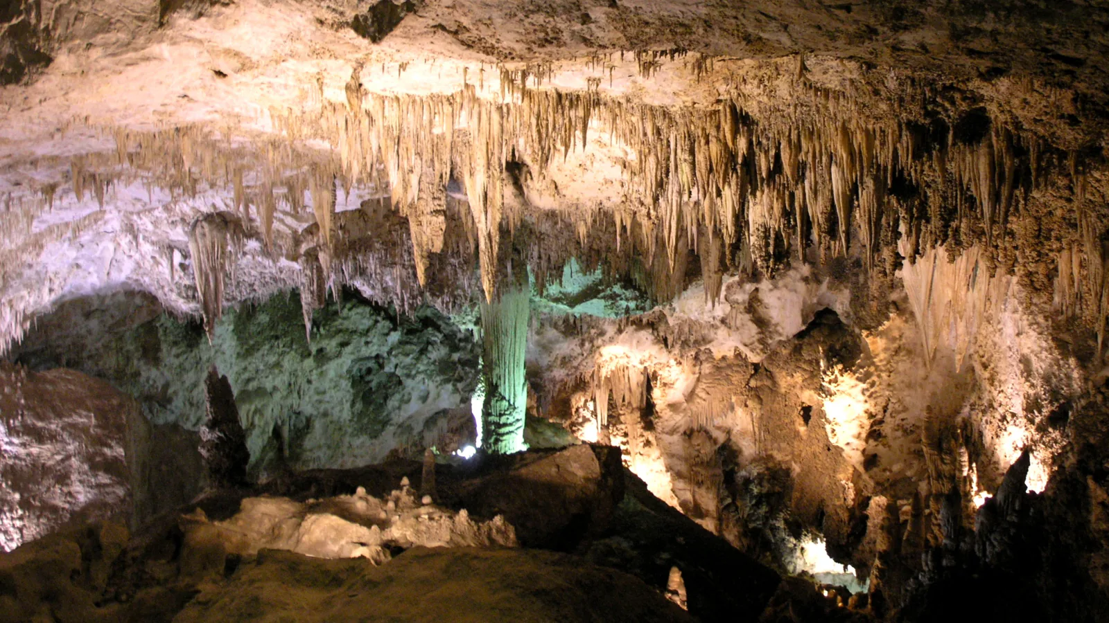
Most visitors descend into Carlsbad Cavern and never walk far across the country that protects it. Above ground, the park covers dry limestone ridges, broad washes, old guano-hauling roads, and a few tough paths through the northern Chihuahuan Desert.
This is a short list on purpose. Three routes have sound, reviewed map and profile data and are currently outside the park's flood-damage closures. They range from the steep mile to Slaughter Canyon Cave to long days in North Slaughter and Yucca canyons. The paved cavern walks are described separately because they require a timed entry and are not interchangeable with the exposed surface trails.
As of August 2026, Guadalupe Ridge between the visitor center and Slaughter Canyon, Rattlesnake Canyon, Juniper Ridge, and Walnut Canyon Desert Drive remain closed after flood damage. Fire restrictions can also change quickly. Read the live alerts, then ask a ranger about the chosen route and access road before setting out.
What changes a hiking day here
Reserve the cavern separately
Timed entry is required for Carlsbad Cavern. A reservation selects an entry time, while the entrance ticket is purchased at the visitor center. Surface hikes do not replace that reservation, and entry to Slaughter Canyon Cave is possible only on a ranger-guided tour.
Carry every drop you expect to drink
There is no dependable backcountry water. NPS advises at least one gallon per person per day and recommends avoiding the hottest hours, roughly 10 a.m. to 4 p.m. Summer temperatures can exceed 100 degrees Fahrenheit.
Bring real navigation
Cairns mark much of the backcountry, phone reception is limited, and canyon branches can look alike. Carry the park map, a topographic map and compass, plus an offline copy of the route. Set a turnaround time before the hike begins.
Leave pets off the trails
Pets are prohibited on park trails and in the backcountry. The surface routes are also poor places to improvise: loose rock, cactus, rattlesnakes, flash floods, and sharp temperature swings reward conservative choices.
| Trail | Distance | Time | Difficulty | Best for |
|---|---|---|---|---|
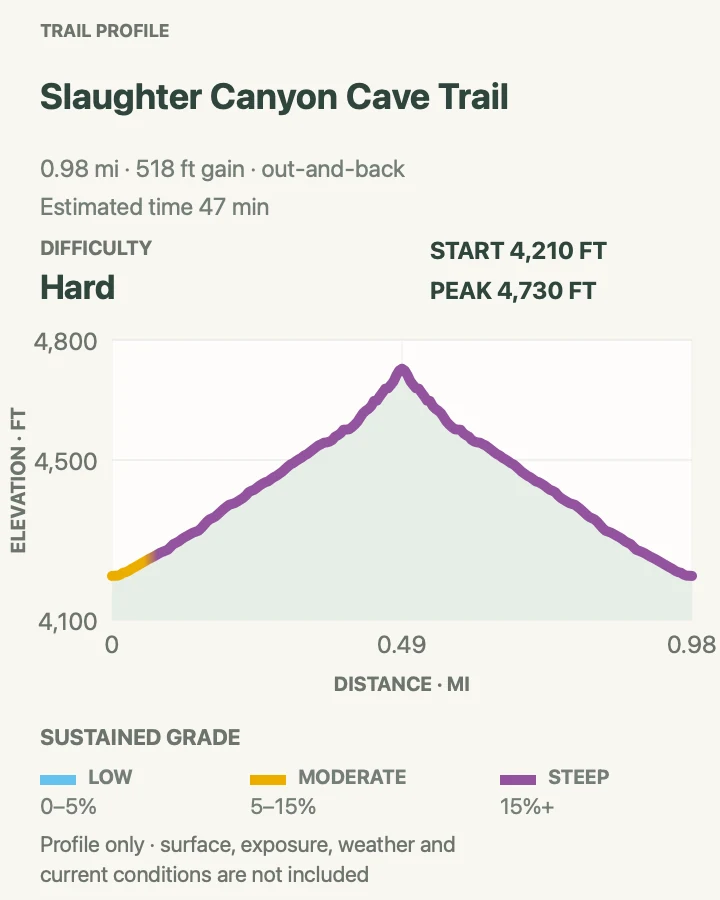
| Slaughter Canyon Cave Trail | 1 mile out and back | 47 min | Hard | A short, steep climb with broad canyon views |
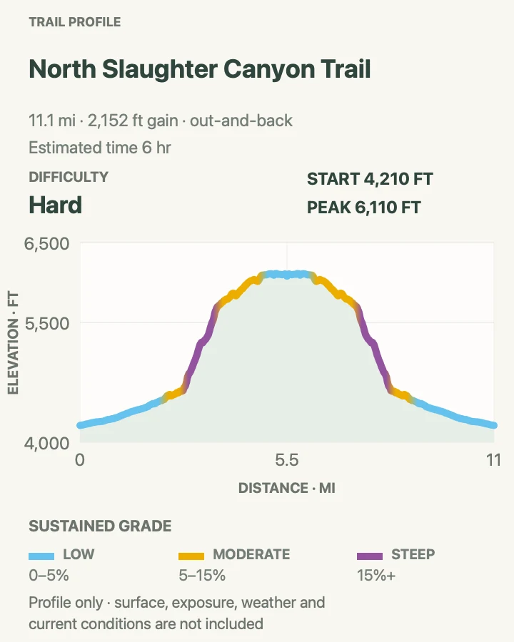
| North Slaughter Canyon | About 11.2 miles out and back | 6 hr | Hard | A long, remote canyon day without joining the closed ridge section |
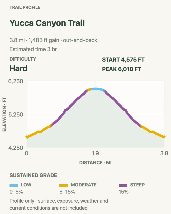
| Yucca Canyon Escarpment | About 3.9 miles out and back | 3 hr | Hard | A steep escarpment climb without attempting the entire backcountry route |
Slaughter Canyon Cave Trail
- Distance
- 1 mile out and back
- Elevation gain
- 520 feet
- Time
- 47 min
- Difficulty
- Hard
- Route type
- out-and-back
- Parking
- Use the Slaughter Canyon parking area south of the main cavern road; confirm the access road is open before driving in.
- Best time
- Early morning in cool weather, or as part of a reserved ranger-guided cave tour.
- Pets
- Pets are not allowed on the trail.
One half-mile gains roughly 500 feet from the canyon floor to the mouth of Slaughter Canyon Cave. The tread is narrow, rocky, and steeper than the mileage suggests. The return is quick but loose enough to deserve careful footing.
Hikers may walk to the entrance without a tour reservation, but the cave beyond it is closed except on ranger-guided tours. Carry water even for this short climb; the exposed slope heats fast and offers almost no shade.
What helps on this route
- Treat the cave entrance as the turnaround unless you hold a tour reservation.
- Save a little time for the view down Slaughter Canyon rather than racing the descent.
Terrain and access: Narrow rocky path, about 500 feet of climbing in half a mile, loose descent, open sun, limestone ledges, and no water.

North Slaughter Canyon
- Distance
- About 11.2 miles out and back
- Elevation gain
- 2,150 feet
- Time
- 6 hr
- Difficulty
- Hard
- Route type
- out-and-back
- Parking
- Start at the Slaughter Canyon parking area and leave room for ranger and emergency access.
- Best time
- A cool, stable day in late autumn, winter, or early spring.
- Pets
- Pets are not allowed in the backcountry.
This route enters broad Slaughter Canyon, follows Middle Slaughter, and continues into the North Slaughter branch. The wash and canyon junctions create more navigation work than a maintained front-country trail. The reviewed line stops before using the closed visitor-center portion of Guadalupe Ridge.
NPS describes the full Slaughter Canyon route to the ridge as 5.3 miles one way and recommends a topographic map for anyone traveling beyond a short canyon visit. Turn back if cairns disappear, clouds build, or progress falls behind the chosen turnaround time.
What helps on this route
- Record the major canyon junctions on the way in; they can look different on the return.
- Avoid the route when thunderstorms could send water through the wash.
Terrain and access: Broad wash, branching canyons, cairned and faint tread, loose limestone, sustained climbing, open exposure, and long stretches without facilities.

Yucca Canyon Escarpment
- Distance
- About 3.9 miles out and back
- Elevation gain
- 1,480 feet
- Time
- 3 hr
- Difficulty
- Hard
- Route type
- out-and-back
- Parking
- Reach the Yucca Canyon trailhead by the dirt access road near the Slaughter Canyon turnoff; high clearance or four-wheel drive is recommended.
- Best time
- A cool, dry morning after confirming road and fire conditions with a ranger.
- Pets
- Pets are not allowed on the trail.
Yucca Canyon climbs sharply from the desert basin toward the top of the escarpment. The mapped 3.9-mile out-and-back is a shorter turnaround on the park's much longer route, which runs 7.7 miles one way toward Big Canyon and gains about 1,520 feet.
The access road may be the first obstacle, and the upper country is still remote. Use the saved turnaround rather than treating the profile as permission to push farther. Ponderosa pine appears in this higher ground, a striking change from the lower desert.
What helps on this route
- Do not drive the access road beyond the capability of the vehicle; walking extra road mileage is safer than getting stranded.
- Carry the official backcountry map even on the shorter version because the route continues beyond the marked turnaround.
Terrain and access: Steep canyon climb, rocky escarpment, exposed desert, sparse cairns, rough access road, upper-elevation pines, and no dependable water.

Official planning sources
Trail access and safety details were checked against these National Park Service pages. The maps and profiles use the reviewed route geometry stored with this guide.
Map data © OpenStreetMap contributors. Trail geometry and planning details include National Park Service public information.