10 Best Hikes in Guadalupe Mountains National Park
Ten Guadalupe Mountains hikes for desert history, springs, McKittrick Canyon, Dog Canyon, and the high country, with reviewed maps, profiles, and live park alerts.
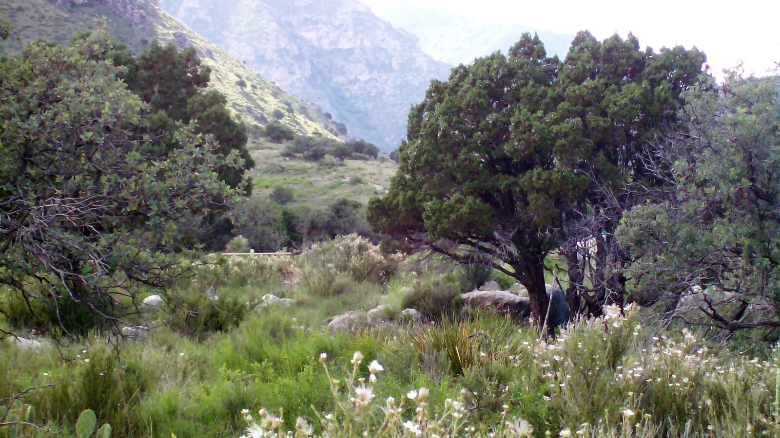
Guadalupe Mountains is a park of abrupt transitions. Bare Chihuahuan Desert rises into conifer forest, a dry canyon shelters a spring, and the highest point in Texas stands only four trail miles from Pine Springs. Distance alone gives a poor sense of the effort.
These ten hikes are arranged by what they offer, not by popularity. The Pinery and McKittrick nature loop work on short visits; Smith Spring and the lower Frijole trail show the desert's scarce water; Guadalupe Peak, Hunter Peak, Permian Reef, and Bush Mountain demand a full day. McKittrick Canyon and Dog Canyon add two very different approaches to the backcountry.
Guadalupe is remote and has no fuel, restaurant, lodging, or grocery inside the park. Pine Springs, McKittrick Canyon, Frijole Ranch, and Dog Canyon are separate trailheads, and Dog Canyon is a two-hour drive from Pine Springs. Check current NPS alerts before the drive; summer thunderstorms, flash flooding, winter ice, and winds above 50 miles per hour can change a sensible plan quickly.
What changes a hiking day here
Carry the day's water from the trailhead
The park recommends one gallon per person per day. Backcountry water is unreliable, and springs are wildlife habitat rather than a drinking supply. Heat is greater at lower desert elevations, even when Pine Springs feels tolerable.
Make wind a go-or-no-go decision
The exposed escarpment can receive gusts above 70 miles per hour, especially from November through March. Guadalupe Peak, Hunter Peak, and Permian Reef lose much of their safety margin when balance is difficult on loose rock.
Leave McKittrick Canyon before the gate closes
McKittrick Canyon is day use only from 8 a.m. to 5 p.m. Mountain Time, and the highway gate is locked each evening. A phone may display a neighboring time zone, so use Mountain Time and choose a hard turnaround.
Treat Dog Canyon as a separate trip
Dog Canyon is roughly 110 road miles from Pine Springs and has intermittent ranger staffing. Fill the fuel tank, carry offline directions, and arrive with all food and water needed for the northern trails.
| Trail | Distance | Time | Difficulty | Best for |
|---|---|---|---|---|
| The Pinery Trail | 1 mi | 1 hr | Easy | A short desert-history walk beside Pine Springs |
| Smith Spring and Manzanita Spring Loop | 2.5 mi | 1 hr 30 min | Moderate | A compact loop through desert, orchard, and spring-fed woodland |
| Frijole Trail | 3 mi | 2 hr | Moderate | Open foothills and a quiet lower-elevation workout |
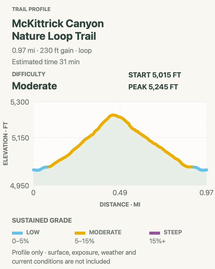
| McKittrick Canyon Nature Loop | 1 mi | 31 min | Moderate | Permian geology and desert plants in under an hour |
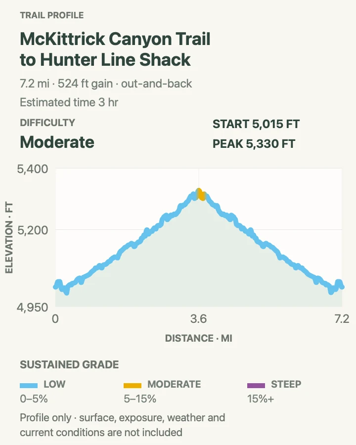
| McKittrick Canyon to Hunter Line Shack | 7.2 mi | 3 hr | Moderate | The canyon's long riparian walk, Pratt Cabin, Grotto, and stone shack |
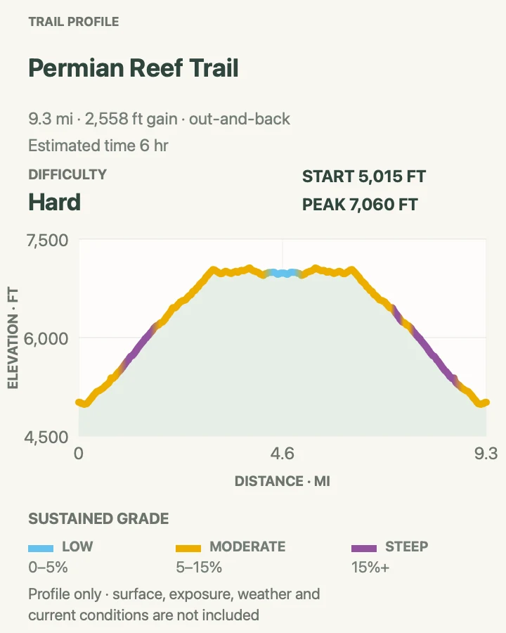
| Permian Reef Trail | 9.4 mi | 6 hr | Hard | A steep geologic climb above McKittrick Canyon |
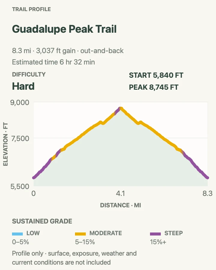
| Guadalupe Peak Trail | 8.5 miles | 6 to 8 hours | Hard | The 8,751-foot summit and highest point in Texas |
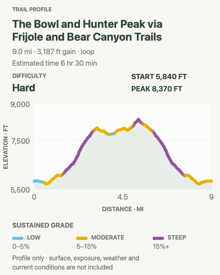
| The Bowl and Hunter Peak via Bear Canyon | 9.2 mi | 6 hr 30 min | Hard | The park's steepest climb, high forest, and a quieter summit |
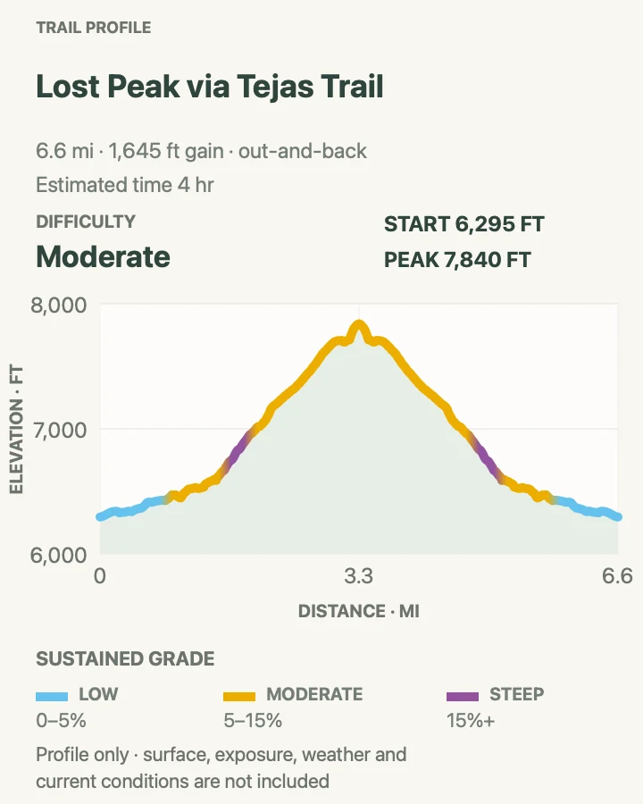
| Lost Peak via Tejas Trail | 6.7 mi | 4 hr | Moderate | A quiet northern summit and broad desert views |
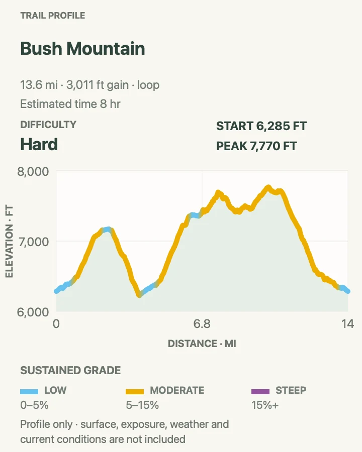
| Bush Mountain Loop from Dog Canyon | 13.7 mi | 8 hr | Hard | A remote all-day circuit through the northern high country |
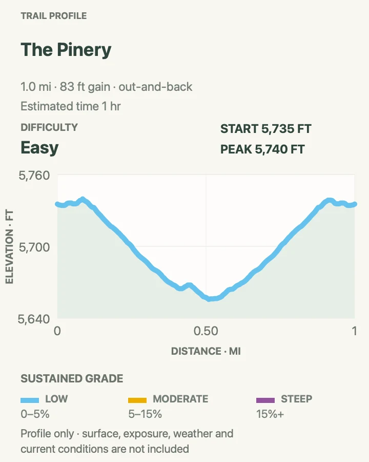
The Pinery Trail
- Distance
- 1 mi
- Elevation gain
- 85 feet
- Time
- 1 hr
- Difficulty
- Easy
- Route type
- out-and-back
- Parking
- Use the Pine Springs Visitor Center lot and follow the paved path toward the Butterfield stage station ruins.
- Best time
- Morning or late afternoon in any season with safe wind and temperature.
- Pets
- Pets are not allowed on park trails. Trained service animals are allowed.
The Pinery reaches the stone remains of an 1858 Butterfield Overland Mail station near the base of the mountains. The walk is short and nearly level, but the ruins make the desert corridor feel less empty and give a clear view of El Capitan's limestone face.
This is the most practical trail while waiting for the visitor center or after a longer hike. There is little shade. Wind and reflected heat can be strong even on a paved route, so carry water and do not climb on the fragile masonry.
What helps on this route
- Read the exhibits at the ruins before looking back toward the old travel corridor.
- Combine it with Frijole Ranch only by car; walking the highway shoulder is unsafe.
Terrain and access: Paved and compacted path, gentle grade, exposed desert, historic stone ruins, strong sun, and open wind.

Smith Spring and Manzanita Spring Loop
- Distance
- 2.5 mi
- Elevation gain
- 400 feet
- Time
- 1 hr 30 min
- Difficulty
- Moderate
- Route type
- loop
- Parking
- Use the Frijole Ranch parking area and begin beside the ranch museum and spring complex.
- Best time
- Cool morning in spring or fall; autumn color can appear around Smith Spring.
- Pets
- Pets are not allowed on park trails. Trained service animals are allowed.
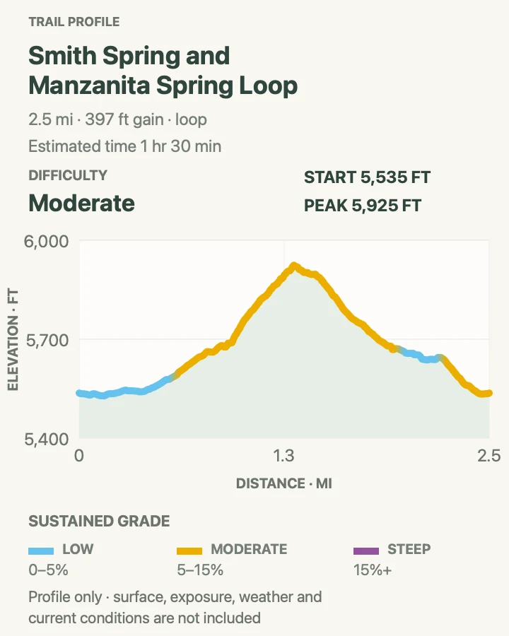
The route passes Manzanita Spring, crosses dry foothill country, then curls into the shaded pocket around Smith Spring. That sudden change in plant life explains more about the Guadalupes than another overlook: water turns bare limestone country into a small woodland refuge.
The spring itself is protected. Stay on the narrow trail, keep out of the water, and give wildlife room to drink. Loose rock and several steeper pieces make this more involved than its 2.5 miles suggest.
What helps on this route
- Walk clockwise if you prefer to finish with the gentler ranch-side grade.
- Carry binoculars and wait quietly near the approach rather than crowd the water.
Terrain and access: Desert grassland, ranch paths, rocky foothill trail, spring-fed shade, short climbs, and narrow tread near sensitive water.

Frijole Trail
- Distance
- 3 mi
- Elevation gain
- 660 feet
- Time
- 2 hr
- Difficulty
- Moderate
- Route type
- out-and-back
- Parking
- Start at Frijole Ranch for the mapped out-and-back segment and remain in marked visitor parking.
- Best time
- A cool winter day or early spring and fall morning.
- Pets
- Pets are not allowed on park trails. Trained service animals are allowed.
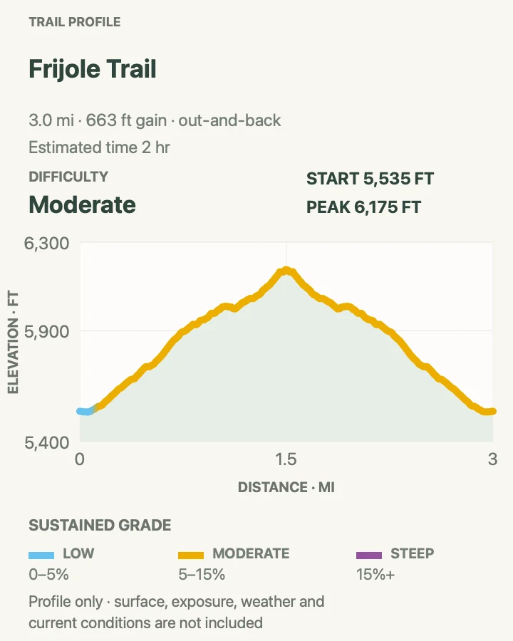
Frijole traverses the lower eastern slopes through juniper and grassland. This three-mile sample is useful when the peaks are hidden by cloud or wind makes the upper trails a poor choice. Views reach across the desert while the limestone wall stays close above.
Several paths connect around Frijole Ranch, including the Foothills route and Bear Canyon approach. Carry the current area map so an inviting junction does not turn a short out-and-back into a much longer loop.
What helps on this route
- Use it as a late-day walk only after fixing a turnaround time before sunset.
- Watch for cactus beside the narrow tread and avoid stepping into desert crust.
Terrain and access: Rolling foothill dirt, juniper grassland, loose limestone, open sun, several trail junctions, and modest climbing.

McKittrick Canyon Nature Loop
- Distance
- 1 mi
- Elevation gain
- 230 feet
- Time
- 31 min
- Difficulty
- Moderate
- Route type
- loop
- Parking
- Enter the McKittrick Canyon day-use road after 8 a.m. and use the visitor-center trailhead lot.
- Best time
- Morning year-round, or late October and early November for changing foliage.
- Pets
- Pets are not allowed on park trails. Trained service animals are allowed.
The nature loop climbs a small ridge above the canyon entrance, crosses an intermittent seep, and returns through juniper and desert shrubs. Exhibits connect the exposed fossil reef to the living plant communities around it.
One mile is enough to gain about 216 feet here. The tread is rockier than an urban nature path, and the seep may be dry. Finish well before the 5 p.m. gate closure even if the visitor center building is unstaffed.
What helps on this route
- Walk this first if clouds make a longer McKittrick trip uncertain.
- Use the ridge view to judge heat and wind before entering the main canyon.
Terrain and access: Short rocky loop, ridge climb, juniper, desert shrubs, intermittent seep, interpretive signs, and no guaranteed water.

McKittrick Canyon to Hunter Line Shack
- Distance
- 7.2 mi
- Elevation gain
- 520 feet
- Time
- 3 hr
- Difficulty
- Moderate
- Route type
- out-and-back
- Parking
- Use the McKittrick Canyon trailhead lot after the day-use gate opens at 8 a.m. Mountain Time.
- Best time
- A cool morning, especially during the autumn foliage period; return before the 5 p.m. gate lock.
- Pets
- Pets are not allowed on park trails. Trained service animals are allowed.
The main canyon trail follows South McKittrick Creek past Pratt Cabin and the Grotto before reaching the Hunter Line Shack. The canyon walls narrow and the plant community shifts repeatedly, from open desert to maple, oak, and pine around the watercourse.
This turnaround avoids the severe climb toward the Notch, but seven miles still require an early start under fixed gate hours. Remain on trail and out of the creek. The canyon's water, plants, and stone structures are easily damaged by detours.
What helps on this route
- Set an alarm for the turnaround in Mountain Time rather than trusting automatic phone time.
- Pack lunch for the route; no food or fuel is sold in the park.
Terrain and access: Canyon-floor trail, repeated creek crossings on rock, gravel, woodland shade, historic structures, gentle climbing, and a strict closing time.

Permian Reef Trail
- Distance
- 9.4 mi
- Elevation gain
- 2,560 feet
- Time
- 6 hr
- Difficulty
- Hard
- Route type
- out-and-back
- Parking
- Begin at the McKittrick Canyon visitor area within its 8 a.m. to 5 p.m. Mountain Time access window.
- Best time
- A cool clear morning with low wind and enough time for the gate deadline.
- Pets
- Pets are not allowed on park trails. Trained service animals are allowed.
Permian Reef gains roughly 2,000 feet in its first three miles, following the fossil escarpment above the canyon entrance. Higher up, the grade eases into forest near Wilderness Ridge and views open east across the desert.
The 9.4-mile round trip has little water and more sun than the main canyon. Loose limestone, exposure, and the locked evening gate make pace important. Turn around early if wind begins moving you off line or storms build over the ridge.
What helps on this route
- Carry the full day's water from the trailhead; do not plan around springs.
- Write the gate-closing time on the map and work backward from a conservative descent pace.
Terrain and access: Steep exposed escarpment, loose limestone, switchbacks, high ridge, forested upper tread, strong wind, and about 2,000 feet of early climbing.

Guadalupe Peak Trail
- Distance
- 8.5 miles
- Elevation gain
- 3,040 feet
- Time
- 6 to 8 hours
- Difficulty
- Hard
- Route type
- out-and-back
- Parking
- Use the Pine Springs trailhead lot beyond the visitor center; arrive early during spring and fall weekends.
- Best time
- A cool, low-wind day in spring or fall, starting near sunrise.
- Pets
- Pets are not allowed on park trails. Trained service animals are allowed.
Guadalupe Peak climbs 3,000 feet from Pine Springs in 4.2 miles. The steepest switchbacks arrive in the first mile and a half, followed by north-facing forest, a false summit, a short bridge, and the final exposed climb to the metal summit marker.
The peak is famous, but it is not an automatic choice. High wind, ice, heat, or lightning can turn the upper mile into the wrong place to be. Stay on the hiker trail, avoid cutting switchbacks, and save enough energy for the long rocky descent.
What helps on this route
- Check the Bowl and summit forecasts, not only the temperature at park headquarters.
- Skip the small summit crowd and descend if gusts threaten balance near the edge.
Terrain and access: Sustained rocky switchbacks, 3,000 feet of ascent, shaded north slope, false summit, exposed final ridge, high wind, and possible winter ice.

The Bowl and Hunter Peak via Bear Canyon
- Distance
- 9.2 mi
- Elevation gain
- 3,190 feet
- Time
- 6 hr 30 min
- Difficulty
- Hard
- Route type
- loop
- Parking
- Use Pine Springs trailhead parking; the route returns through the Frijole and Foothills trail network.
- Best time
- A cool clear day in spring or fall with an early start.
- Pets
- Pets are not allowed on park trails. Trained service animals are allowed.
Bear Canyon gains about 2,000 feet in less than two miles, climbing directly from the desert to the forested Bowl. Rangers advise going up Bear Canyon instead of descending it. From the rim, the route reaches Hunter Peak before looping back through the high country and Frijole system.
This is a harder day than its nine miles imply. The ascent faces morning sun, the summit catches wind, and the return contains enough junctions to punish hurried navigation. Photograph the Pine Springs map and verify every signed turn.
What helps on this route
- Climb Bear Canyon and use the gentler Frijole side for the descent.
- Bring poles for loose steps and tired legs late in the loop.
Terrain and access: Very steep canyon trail, 2,000 feet of rapid ascent, high forest, rocky summit spur, long loop junctions, sun, and wind exposure.

Lost Peak via Tejas Trail
- Distance
- 6.7 mi
- Elevation gain
- 1,650 feet
- Time
- 4 hr
- Difficulty
- Moderate
- Route type
- out-and-back
- Parking
- Begin at the remote Dog Canyon trailhead and pay the park entry fee before hiking.
- Best time
- Winter, spring, or fall on a day without severe wind; summer heat can be unsafe.
- Pets
- Pets are not allowed on park trails. Trained service animals are allowed.
Tejas Trail climbs a little over three miles from Dog Canyon to Lost Peak Saddle. The final summit is a short off-trail walk over open rock, which requires a current off-trail permit under park rules. Hikers who do not have one should turn at the signed saddle and keep the excellent western view.
Dog Canyon begins higher than Pine Springs, but summer can still be dangerously hot. Winter and spring winds may exceed 30 miles per hour. The remote trailhead has limited services and little cellular coverage.
What helps on this route
- Ask about the current off-trail permit before leaving the ranger-station area.
- Carry a paper map for the saddle even though the main Tejas tread is distinct.
Terrain and access: Steady rocky Tejas climb, higher desert grassland, open saddle, optional off-trail summit rock, strong wind, and remote access.

Bush Mountain Loop from Dog Canyon
- Distance
- 13.7 mi
- Elevation gain
- 3,010 feet
- Time
- 8 hr
- Difficulty
- Hard
- Route type
- loop
- Parking
- Use Dog Canyon trailhead parking after the two-hour drive around from Pine Springs.
- Best time
- A long spring or fall day with cool temperatures, low wind, and ample daylight.
- Pets
- Pets are not allowed on park trails. Trained service animals are allowed.
This long loop links Bush Mountain, Blue Ridge, and the northern trail system above Dog Canyon. It passes grassland, forest, remote camps, and the western escarpment while staying far from the busier Pine Springs summits.
Thirteen-plus miles, numerous junctions, and limited emergency response make this an advanced day. Sections near West Dog Canyon can become grassy and difficult to follow. Carry a paper topographic map, compass, extra food, and a turnaround plan that protects the final descent.
What helps on this route
- Confirm the intended loop and recent tread condition with park staff before departure.
- Do not depend on a phone signal or a single downloaded app for the northern junctions.
Terrain and access: Remote high-country loop, forest and grassland, escarpment exposure, loose rock, many junctions, possible overgrown tread, strong wind, and more than thirteen miles.

Official planning sources
Trail access and safety details were checked against these National Park Service pages. The maps and profiles use the reviewed route geometry stored with this guide.
- NPS: Current alerts and conditions
- NPS: Official trail descriptions
- NPS: Day-hiking planning
- NPS: McKittrick Canyon hours and access
- NPS: Operating hours in Mountain Time
- NPS: Dog Canyon access and rules
- NPS: Lost Peak Saddle day hike
- NPS: Guadalupe weather and wind
- NPS: Parking areas and trailheads
- NPS: Directions, fuel, and services
Map data © OpenStreetMap contributors. Trail geometry and planning details include National Park Service public information.