12 Best Hikes in Great Basin National Park
Twelve Great Basin hikes for bristlecone pines, alpine lakes, quiet creeks, mining history, and Wheeler Peak, with reviewed maps, profiles, and live road alerts.
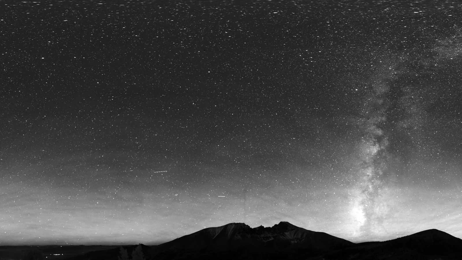
Great Basin rises nearly eight thousand feet from desert basin to Wheeler Peak. The hiking changes just as sharply. A morning can begin among sagebrush near the cave visitor center and end beside snowfields and bristlecone pines above ten thousand feet.
These twelve routes are grouped by the roads that make them possible. Wheeler Peak supplies the famous high-country walks; Baker Creek holds quieter forest loops and lake approaches; lower trailheads add mining history and short orientation walks. A cave tour is worthwhile, but it requires a ticket and a ranger, so it is not padded into a hiking list.
As of late August 2026, Wheeler Peak Scenic Drive and the Baker, Strawberry, and Snake Creek roads are open. Snow can close the upper road at any time, and most non-scenic-drive trailheads require gravel or dirt-road travel. Check the live status immediately before leaving Baker; a sunny valley forecast does not describe conditions at 10,000 feet.
What changes a hiking day here
Treat elevation as part of the mileage
The upper trailhead is near 10,000 feet and Wheeler Peak reaches 13,063 feet. Ascend gradually, drink water, and descend if headache, nausea, unusual breathlessness, or confused speech appears. Fitness does not prevent altitude illness.
Finish exposed ridges before storms build
Summer lightning can arrive quickly, with ridge winds of 30 to 60 miles per hour. Start Wheeler Peak and the high lakes early. Leave summits and open ridges at the first thunder or dark, fast-growing clouds.
Road choice changes the hike
Only Wheeler Peak Scenic Drive is paved. Baker Creek, Snake Creek, and other approaches can close after snow or storms. Vehicles longer than 24 feet cannot use the upper scenic drive, and trailers need special caution.
Carry winter layers in summer
Snow can fall in any month at high elevation, while nighttime desert temperatures drop sharply. Bring an insulating layer and shell even when Baker is hot. Surface water must be filtered, boiled, or chemically treated.
| Trail | Distance | Time | Difficulty | Best for |
|---|---|---|---|---|
| Mountain View Nature Trail | 0.4 mi | 9 min | Easy | A short orientation to basin-and-range country |
| Mather Overlook Walk | 0.1 mi | 1 hr | Easy | A quick high-road panorama without a trailhead commitment |
| Stella Lake | 2.1 mi | 1 hr 30 min | Moderate | A short alpine-lake walk beneath Wheeler Peak |
| Bristlecone Pine Grove Trail | 2.8 mi | 1 hr 30 min | Moderate | Ancient trees at the edge of the alpine zone |
| Wheeler Peak via Stella Lake | 8.3 mi | 6 hr 30 min | Hard | The park's major high-elevation summit day |
| Serviceberry Loop | 3.1 mi | 2 hr | Moderate | A moderate Baker Creek loop away from upper-road crowds |
| Baker Creek Loop | 3.5 mi | 2 hr 30 min | Moderate | Creekside forest and a flexible half-day hike |
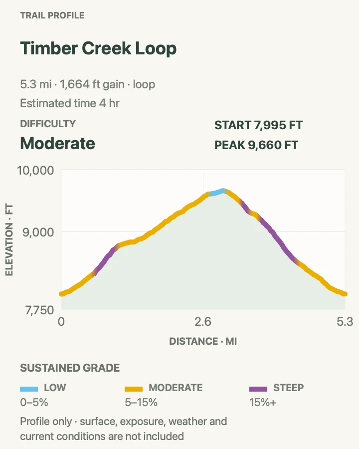
| Timber Creek Loop | 5.3 mi | 4 hr | Moderate | A longer wooded loop with steady creek climbing |
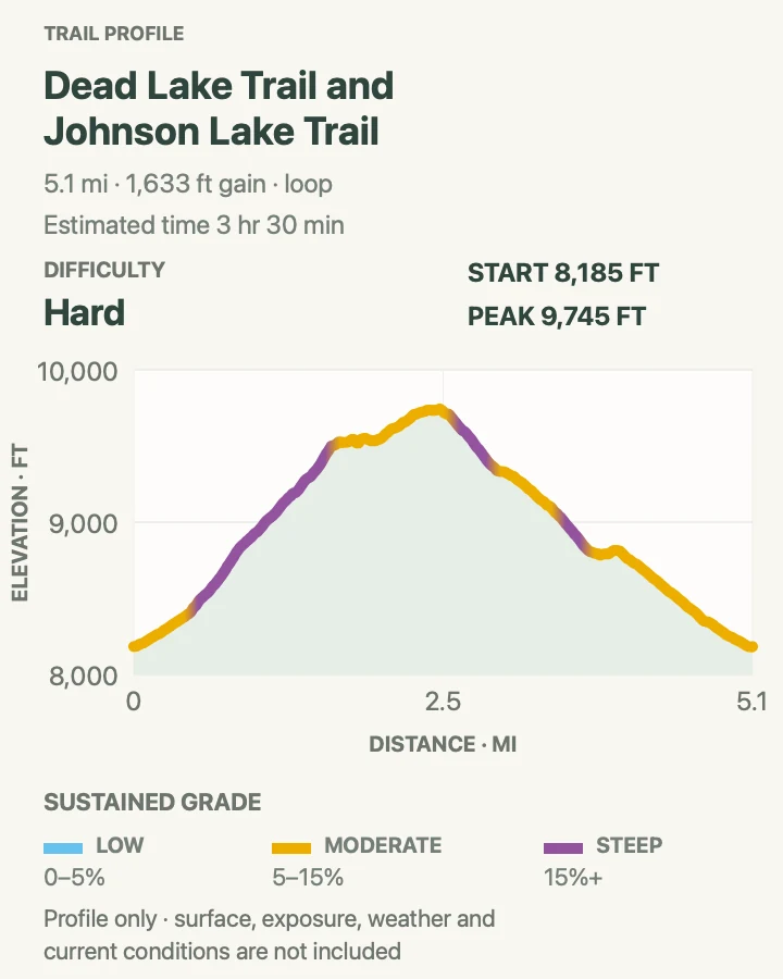
| Dead Lake and Johnson Lake Loop | 5.1 mi | 3 hr 30 min | Hard | A demanding lake loop and first taste of Great Basin backcountry |
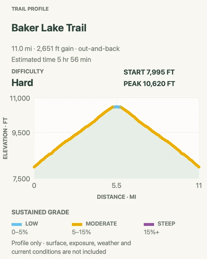
| Baker Lake Trail | 11.1 mi | 5 hr 56 min | Hard | An all-day climb to a quiet alpine lake |
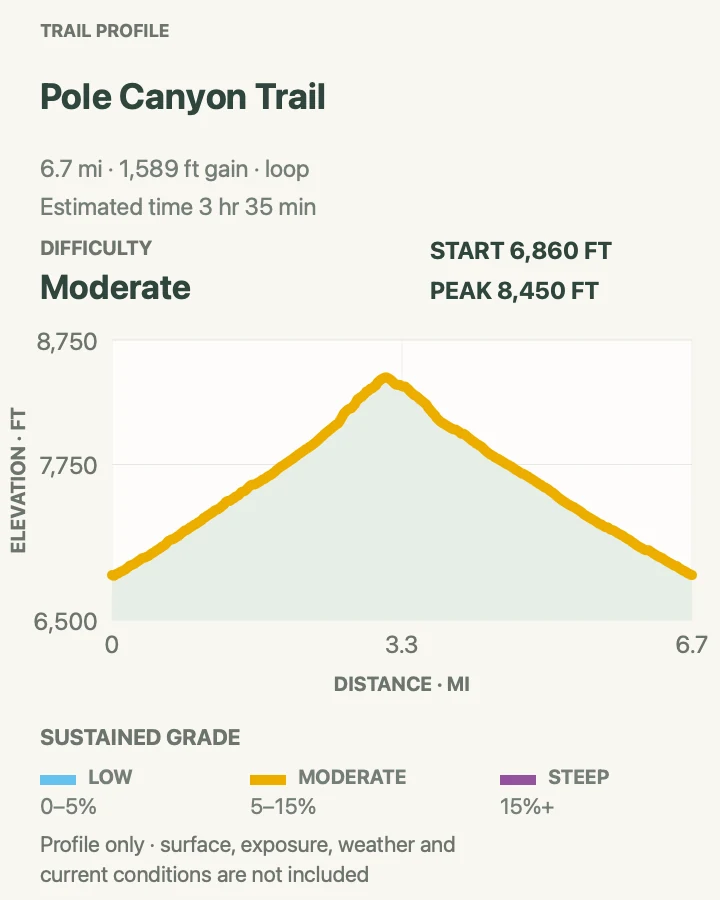
| Pole Canyon Loop | 6.7 mi | 3 hr 35 min | Moderate | Limestone walls and a quieter lower-canyon circuit |
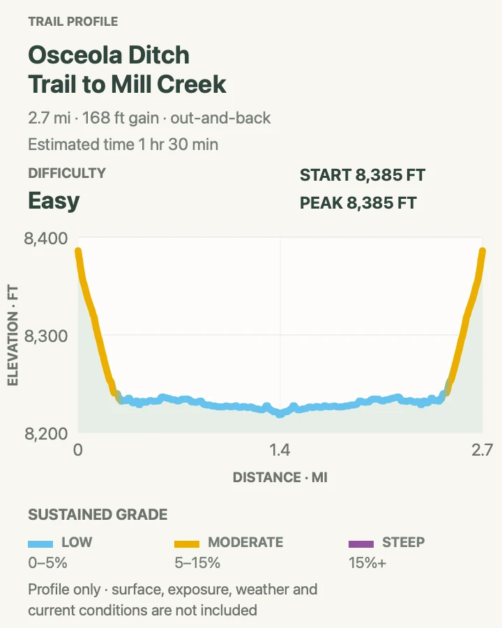
| Osceola Ditch to Mill Creek | 2.7 mi | 1 hr 30 min | Easy | A gentler historic waterworks walk below the alpine zone |
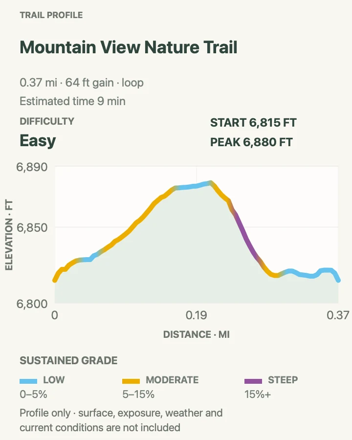
Mountain View Nature Trail
- Distance
- 0.4 mi
- Elevation gain
- 65 feet
- Time
- 9 min
- Difficulty
- Easy
- Route type
- loop
- Parking
- Use the Lehman Caves Visitor Center lot and follow the signed nature-trail start.
- Best time
- Morning or early evening, especially on a cave-tour day with spare time.
- Pets
- Pets are not allowed on park trails. Trained service animals are allowed.
This compact loop above the cave visitor center introduces pinyon-juniper woodland and opens a view toward the Snake Range. Interpretive stops make the four-tenths of a mile more useful than the number suggests.
The lower elevation is warmer than Wheeler Peak, but the sun is still strong and the air dry. Stay on the signed loop around limestone openings and never enter an unmarked cave or mine.
What helps on this route
- Walk it before a cave tour rather than risking a late arrival at the ticket desk.
- Use the overlook to compare valley and mountain weather before driving uphill.
Terrain and access: Short dry loop, pinyon-juniper shade, limestone, gentle slopes, interpretive stops, and exposed viewpoints.

Mather Overlook Walk
- Distance
- 0.1 mi
- Elevation gain
- 0 feet
- Time
- 1 hr
- Difficulty
- Easy
- Route type
- out-and-back
- Parking
- Stop only in the developed Mather Overlook pullout on Wheeler Peak Scenic Drive.
- Best time
- Late afternoon on a clear day, outside lightning and strong wind.
- Pets
- Pets are not allowed on park trails. Trained service animals are allowed.
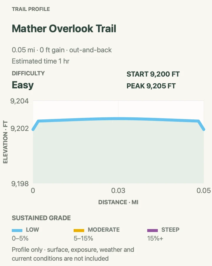
The one-tenth-mile path leaves the pullout for a clearer look across the basin and into the mountain forest. It is a viewpoint walk, not a one-hour hike despite old crowd-sourced timing attached to the route file.
The overlook sits high enough for abrupt weather. Keep children away from loose edges, and do not cross restoration barriers for a slightly different angle.
What helps on this route
- Use it as a weather stop before continuing to the upper trailheads.
- Shift to a lower route if clouds are already building over Wheeler Peak.
Terrain and access: Very short mountain overlook path, loose gravel, road exposure, open edge, wind, and high-elevation weather.

Stella Lake
- Distance
- 2.1 mi
- Elevation gain
- 460 feet
- Time
- 1 hr 30 min
- Difficulty
- Moderate
- Route type
- out-and-back
- Parking
- Use the Bristlecone parking area at the end of Wheeler Peak Scenic Drive; arrive early on summer weekends.
- Best time
- Early summer morning after the trail is snow-free, or September for cool clear air.
- Pets
- Pets are not allowed on park trails. Trained service animals are allowed.
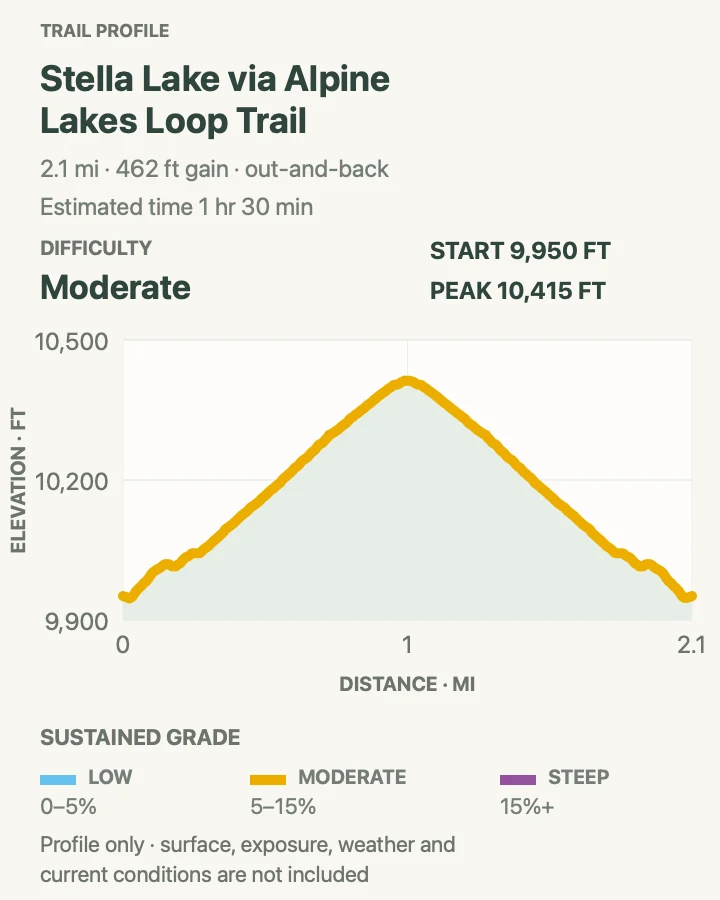
This out-and-back follows part of the Alpine Lakes Loop to Stella Lake, where Wheeler Peak rises sharply beyond the water. It gives a concentrated high-country experience without committing to the full lake circuit or summit.
The trail begins near 10,000 feet, so two miles can feel longer than expected. Snow lingers into summer, and the shore vegetation is fragile. Stay on durable tread and keep away from saturated meadow edges.
What helps on this route
- Continue around the full Alpine Lakes Loop only if weather and acclimatization are both good.
- Avoid walking onto ice; alpine lakes thaw later than valley ponds.
Terrain and access: High-elevation forest, rocky tread, modest climbs, lingering snow, sensitive meadow, lake shore, and thin air.

Bristlecone Pine Grove Trail
- Distance
- 2.8 mi
- Elevation gain
- 620 feet
- Time
- 1 hr 30 min
- Difficulty
- Moderate
- Route type
- out-and-back
- Parking
- Start at the Bristlecone parking area at the end of the open scenic drive.
- Best time
- Morning after snowmelt, before the small lot and trail become busy.
- Pets
- Pets are not allowed on park trails. Trained service animals are allowed.
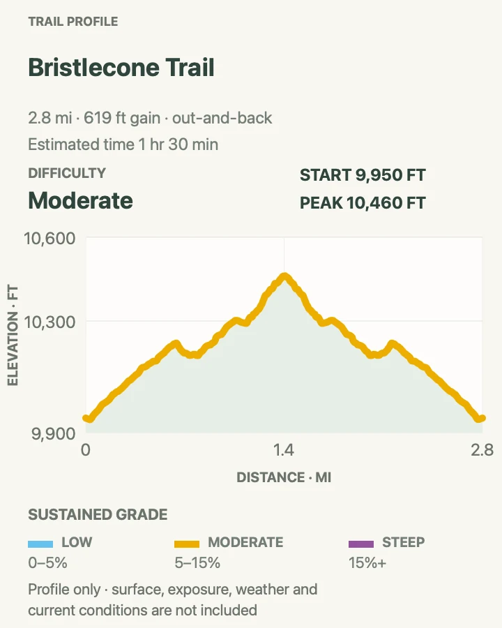
The trail climbs into the Wheeler Peak grove, where wind-shaped bristlecone pines grow from pale limestone. Signs explain how dead-looking wood and living strips can belong to the same tree for thousands of years.
The grove is not a collection site. Do not touch exposed roots, take wood, or leave the path for a photograph. Continue toward the rock glacier only with enough time and a current route map.
What helps on this route
- Move slowly through the signed grove rather than treating it as a summit approach.
- Carry a layer; shade and wind make the grove much cooler than Baker.
Terrain and access: Rocky high-country trail, steady climb, limestone, ancient-tree grove, wind, thin air, and possible lingering snow.

Wheeler Peak via Stella Lake
- Distance
- 8.3 mi
- Elevation gain
- 3,110 feet
- Time
- 6 hr 30 min
- Difficulty
- Hard
- Route type
- out-and-back
- Parking
- Use the upper Wheeler Peak trailhead only when Scenic Drive is open; arrive before dawn on busy summer weekends.
- Best time
- A stable summer morning with the summit completed before afternoon storm development.
- Pets
- Pets are not allowed on park trails. Trained service animals are allowed.
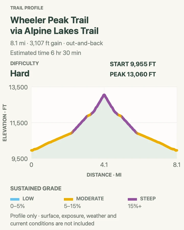
The route passes Stella Lake, crosses a saddle, and climbs Wheeler Peak's broad north ridge to 13,063 feet. Views spread across the Snake Range and desert basins, but the summit is earned through wind, thin air, and loose upper tread.
The 8.3-mile library trace is one common combination; the park's winter guidance describes about five miles each way when road closure forces a different approach. In summer, follow current signs, protect alpine plants, and descend immediately for lightning or altitude symptoms.
What helps on this route
- Spend a night at moderate elevation before the climb if arriving from near sea level.
- Do not hide from lightning beneath the sparse ridge trees; descend toward lower, less exposed ground.
Terrain and access: Alpine lake approach, forest, broad tundra saddle, loose rocky summit ridge, high wind, severe exposure, and more than 2,000 feet of climbing.

Serviceberry Loop
- Distance
- 3.1 mi
- Elevation gain
- 770 feet
- Time
- 2 hr
- Difficulty
- Moderate
- Route type
- loop
- Parking
- Use the signed Baker Creek trailhead at the end of the gravel road when open.
- Best time
- Spring or autumn afternoon, or a summer morning after the road dries.
- Pets
- Pets are not allowed on park trails. Trained service animals are allowed.
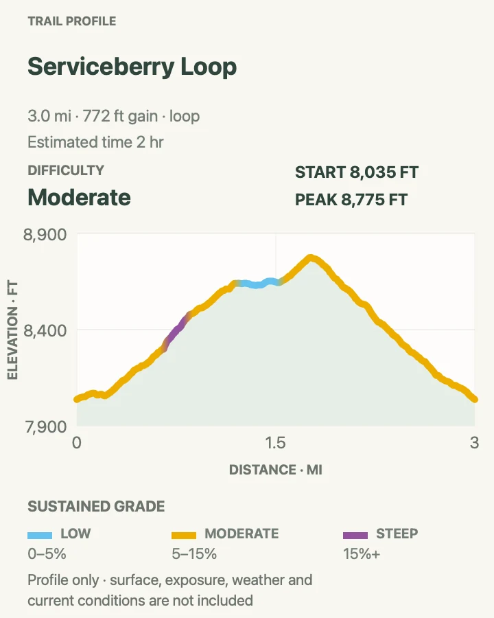
Serviceberry circles through pinyon, mountain brush, and creek-influenced forest near Baker Creek. It is a practical alternative when the Wheeler Peak lot is full or clouds cover the alpine zone.
Trail junctions connect with longer Baker Creek routes. Carry the area map and stay on the intended loop; old tracks and drainages can make a casual shortcut less obvious on the return.
What helps on this route
- Check the gravel road after storms before committing a low-clearance car.
- Use this loop to acclimatize before a higher hike the following day.
Terrain and access: Dry forest, brush, rolling trail, creek proximity, loose soil, signed junctions, and gravel-road access.

Baker Creek Loop
- Distance
- 3.5 mi
- Elevation gain
- 940 feet
- Time
- 2 hr 30 min
- Difficulty
- Moderate
- Route type
- loop
- Parking
- Drive Baker Creek Road to the main trailhead loop when the gravel road is open.
- Best time
- A cool summer morning or autumn day before winter road closure.
- Pets
- Pets are not allowed on park trails. Trained service animals are allowed.
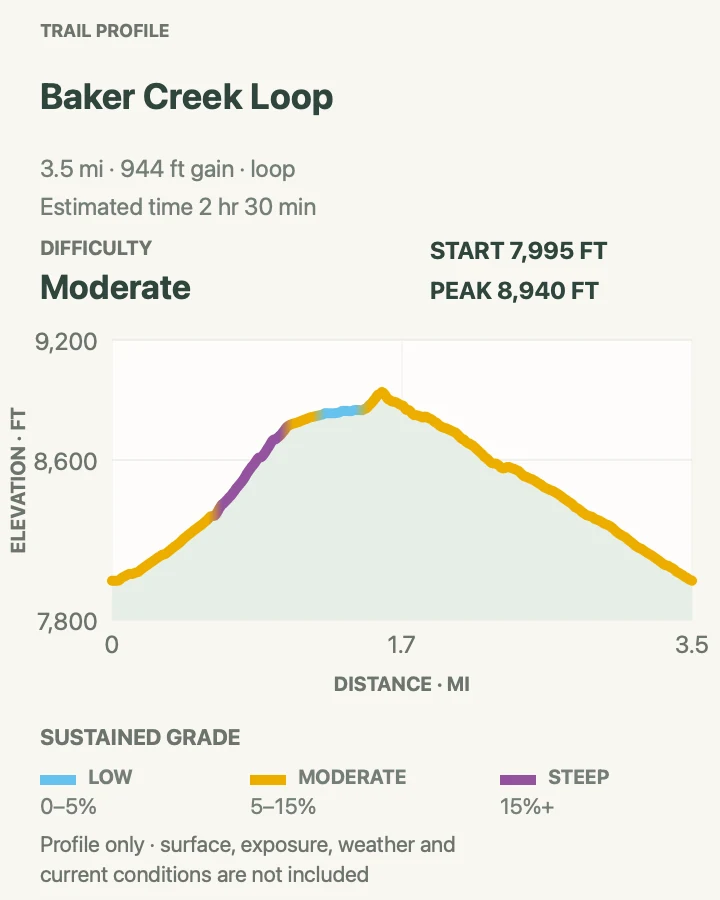
This loop links sections of the Baker Creek and South Fork trail network through aspen, conifer forest, and open creek benches. The repeated habitat changes make it feel longer than three and a half miles.
High water, fallen trees, or snow can affect crossings and junctions. Follow signs rather than an old two-track, and keep livestock or hikers ahead in view before passing on narrow trail.
What helps on this route
- Photograph the trailhead map because several longer routes begin here.
- Filter any creek water; clear mountain flow can still carry giardia.
Terrain and access: Forest loop, creek benches, roots and loose rock, seasonal water crossings, aspen shade, and interconnected trail junctions.

Timber Creek Loop
- Distance
- 5.3 mi
- Elevation gain
- 1,660 feet
- Time
- 4 hr
- Difficulty
- Moderate
- Route type
- loop
- Parking
- Use the Baker Creek trailhead and verify the correct loop junction before leaving the parking area.
- Best time
- Summer after snowmelt, or early fall for aspen color.
- Pets
- Pets are not allowed on park trails. Trained service animals are allowed.
Timber Creek climbs into cooler mixed forest before looping back through the Baker Creek network. It has more sustained walking than Serviceberry without the all-day commitment of Baker Lake.
The five-mile route can hold snow and deadfall after the valley has dried. Budget time for route finding at junctions and avoid stepping around obstacles into fragile creekside vegetation.
What helps on this route
- Ask about recent deadfall if spring trail crews have not reached the loop.
- Carry a warm layer even when the lower campground is comfortable.
Terrain and access: Creekside forest, steady moderate climbs, roots, rock, possible deadfall or snow, and linked Baker Creek trails.

Dead Lake and Johnson Lake Loop
- Distance
- 5.1 mi
- Elevation gain
- 1,630 feet
- Time
- 3 hr 30 min
- Difficulty
- Hard
- Route type
- loop
- Parking
- Begin at the Baker Creek trailhead; backcountry camping requires the current park permit process.
- Best time
- Snow-free summer or early fall with a stable forecast.
- Pets
- Pets are not allowed on park trails. Trained service animals are allowed.
This compact but steep combination climbs through the Johnson and Dead Lake trail system, passing old mining traces and two high basins. Elevation change makes the five miles harder than the distance suggests.
Some connecting segments are primitive. Mines and collapsed workings are dangerous, while wet meadows are easily damaged. Stay out of openings, cross only on durable ground, and register any overnight itinerary.
What helps on this route
- Confirm the loop direction and water crossings with a ranger before starting.
- Do not shorten the route through mining debris or meadow.
Terrain and access: Steep forest trail, primitive connectors, lake basins, old mining ground, loose rock, water crossings, and possible snow.

Baker Lake Trail
- Distance
- 11.1 mi
- Elevation gain
- 2,650 feet
- Time
- 5 hr 56 min
- Difficulty
- Hard
- Route type
- out-and-back
- Parking
- Use the main Baker Creek trailhead at the end of the open gravel road.
- Best time
- A long summer day after snowmelt, starting early enough to avoid afternoon storms.
- Pets
- Pets are not allowed on park trails. Trained service animals are allowed.
Baker Lake sits high beneath the Snake Range, reached by a sustained climb from the Baker Creek drainage. The route trades the crowds of the upper scenic drive for more mileage and a gradual transition through several forest zones.
Eleven miles, altitude, and a remote turnaround make this a serious day. Carry navigation, storm layers, and enough food to handle delays. Backcountry camping requires registration or permits under current park rules.
What helps on this route
- Set a turnaround time before leaving the trailhead, not when clouds appear above the lake.
- Treat water and keep camp or lunch stops off the lake's fragile shore vegetation.
Terrain and access: Long forest ascent, creek crossings, high basin, rocky lake approach, altitude, remote terrain, and possible lingering snow.

Pole Canyon Loop
- Distance
- 6.7 mi
- Elevation gain
- 1,590 feet
- Time
- 3 hr 35 min
- Difficulty
- Moderate
- Route type
- loop
- Parking
- Turn toward Grey Cliffs Campground about 1.5 miles along Baker Creek Road and follow Pole Canyon trailhead signs.
- Best time
- Spring or autumn for comfortable lower-elevation temperatures.
- Pets
- Pets are not allowed on park trails. Trained service animals are allowed.
Pole Canyon climbs beside limestone and dry woodland before looping through open country near Grey Cliffs. It offers geological texture without the altitude of Wheeler Peak.
The route crosses sun-exposed slopes and can be hotter than the Baker Creek forest. Carry more water than the map seems to require, and stay away from mine openings and unstable cliff bases.
What helps on this route
- Choose this when high ridges are stormy but Baker Creek Road remains dry.
- Watch for sharp limestone under loose gravel on descents.
Terrain and access: Limestone canyon, dry woodland, open slopes, loose rock, sustained sun, old mining country, and gravel-road access.

Osceola Ditch to Mill Creek
- Distance
- 2.7 mi
- Elevation gain
- 170 feet
- Time
- 1 hr 30 min
- Difficulty
- Easy
- Route type
- out-and-back
- Parking
- Use the signed Osceola Ditch trailhead around Mile 5 of Wheeler Peak Scenic Drive.
- Best time
- Late spring through fall when the road and tread are snow-free.
- Pets
- Pets are not allowed on park trails. Trained service animals are allowed.
The trail follows part of an old mining-era ditch toward Mill Creek, holding a relatively even contour through forest and open slopes. It is a quieter middle-elevation option between visitor-center walks and upper-mountain hikes.
Ditch edges can crumble and wet sections may be slick. Keep off old structures, watch children near drops, and do not assume the historic grade stays level throughout after storms or maintenance work.
What helps on this route
- Use this route when altitude makes the upper trailhead uncomfortable.
- Carry water even beside the ditch and creek; surface water needs treatment.
Terrain and access: Historic ditch grade, forest, open slopes, eroded edges, occasional wet ground, modest elevation change, and road-access trailhead.

Official planning sources
Trail access and safety details were checked against these National Park Service pages. The maps and profiles use the reviewed route geometry stored with this guide.
Map data © OpenStreetMap contributors. Trail geometry and planning details include National Park Service public information.