8 Best Hikes in Crater Lake National Park
Eight Crater Lake hikes around the caldera rim, volcanic valleys, waterfalls, and Cascade summits, with reviewed maps, elevation profiles, and live park alerts.
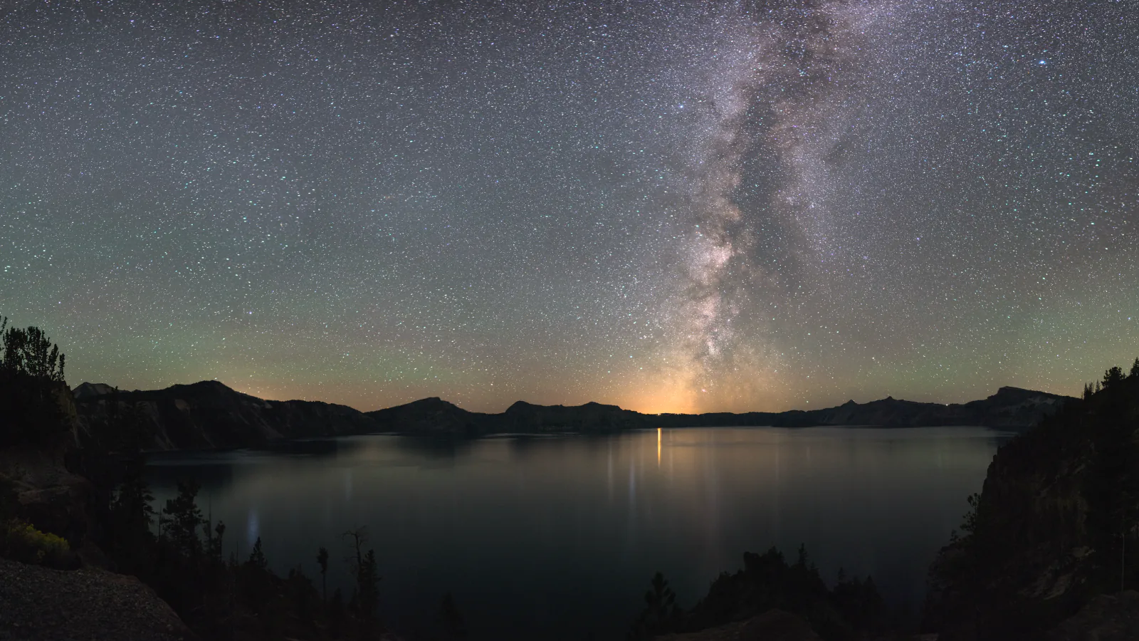
Crater Lake hiking changes with the snowplow. A trail can be clear while the road to its trailhead remains buried or closed for construction, and the park's highest routes commonly hold snow into July. Start with access, then choose mileage.
These eight hikes are not arranged as a popularity chart. Discovery Point and Watchman deliver the lake views most visitors came for; Annie Creek and the Pinnacles explain the older volcanic terrain below the rim; Union Peak and Red Cone Springs move into quieter Cascade backcountry. Plaikni Falls and Crater Peak are included with their current access complications stated plainly.
Cleetwood Cove is absent on purpose. The only legal trail to the lakeshore is closed for major reconstruction through the 2028 season, and public boat tours are unavailable in 2026 and 2027. That also removes Wizard Island as a hike for now. The live park feed below should settle any disagreement with an old map or saved itinerary.
What changes a hiking day here
The rim sits above 7,000 feet
Cool air at the lodge does not eliminate altitude, ultraviolet exposure, or fast weather. Carry layers and water even on short routes. Watchman, Union Peak, and other open summits are poor places to remain when thunder starts building.
East Rim construction breaks the usual circuit
In August 2026, East Rim Drive is closed between park headquarters and Phantom Ship Overlook. Pinnacles Road is open but reachable only by hiking or biking during the project. Crater Peak requires an approach on Grayback Road. Road status, not trail status, controls those outings.
Winter is a different sport
Rim roads close under deep snow, and summer foot trails become ski or snowshoe routes with avalanche terrain. The park does not issue an avalanche forecast. This guide describes snow-free hiking; winter travel needs navigation, avalanche judgment, and a separate route plan.
Stay on the tread near the caldera
The rim combines fragile pumice, steep cliffs, and loose rock above lower switchbacks. Off-trail shortcuts damage plants and can send stones onto other hikers. The lake shore is legally accessible only by Cleetwood Cove, which is currently closed; do not improvise a descent.
| Trail | Distance | Time | Difficulty | Best for |
|---|---|---|---|---|
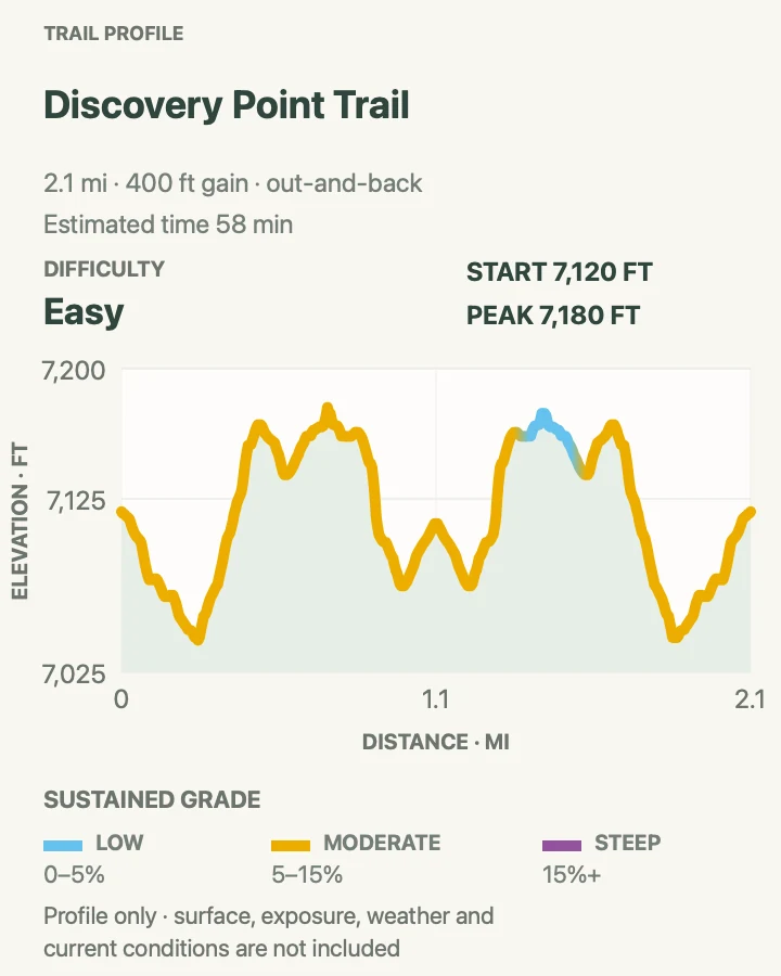
| Discovery Point Trail | 2.2 mi | 58 min | Easy | A first lake-view walk without a summit climb |
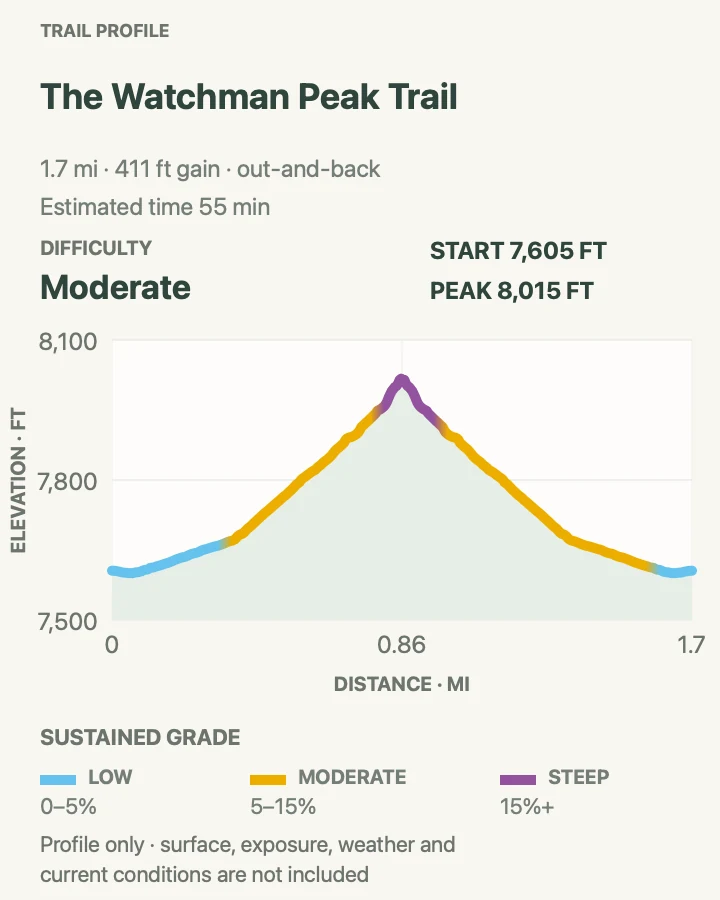
| Watchman Peak Trail | 1.7 mi | 55 min | Moderate | A compact summit with the classic Wizard Island view |
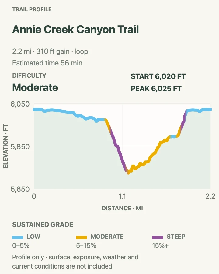
| Annie Creek Canyon Trail | 2.2 mi | 56 min | Moderate | A forest-and-creek loop away from the caldera crowds |
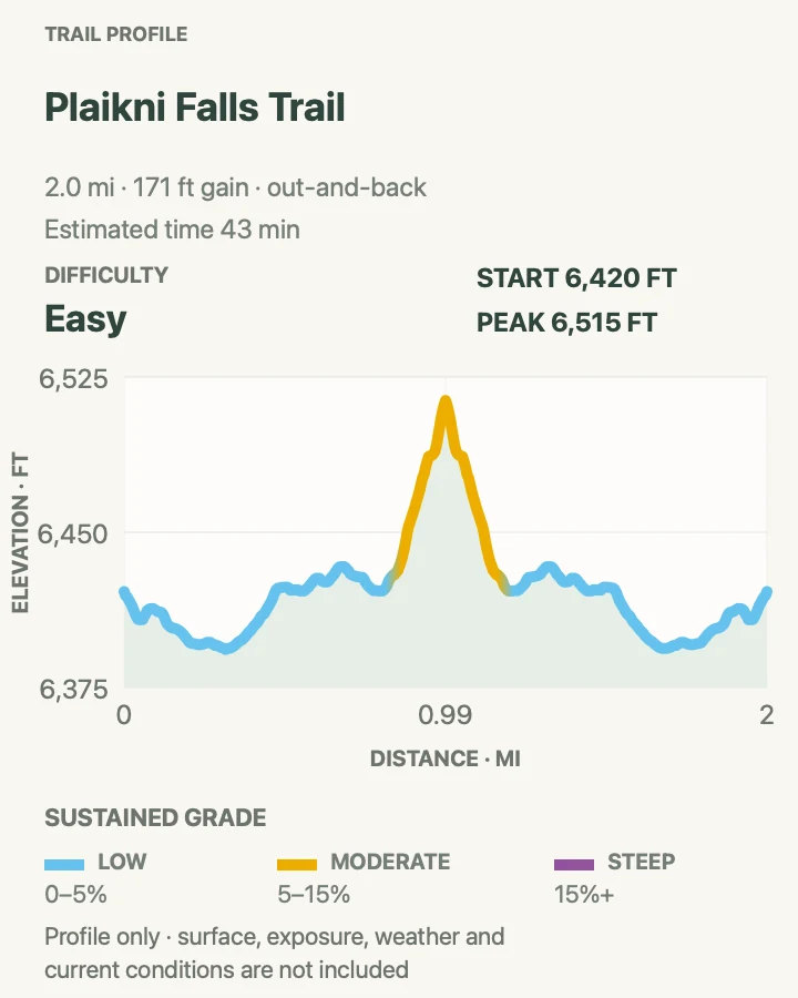
| Plaikni Falls Trail | 2 mi | 43 min | Easy | A gentle forest walk to a snowmelt waterfall |
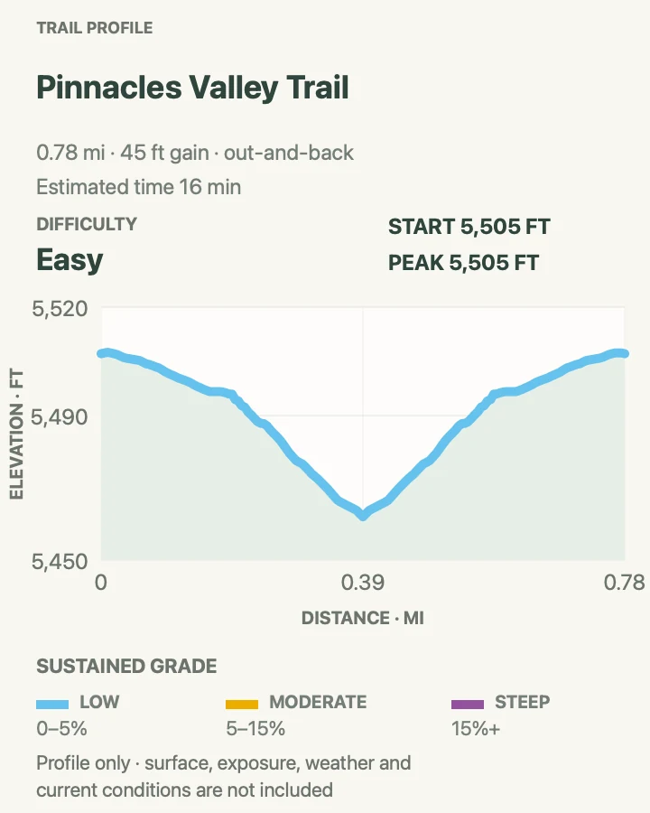
| Pinnacles Valley Trail | 0.8 mi | 16 min | Easy | Volcanic spires with almost no climbing on the trail itself |
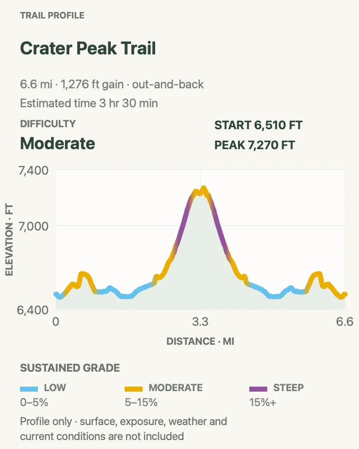
| Crater Peak Trail | 6.6 mi | 3 hr 30 min | Moderate | A quiet forested volcano above the Klamath Basin |
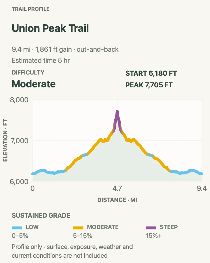
| Union Peak Trail | 9.5 mi | 5 hr | Moderate | A demanding Cascade summit away from Rim Drive |
| Red Cone Springs via the Pacific Crest Trail | 7.8 mi | 3 hr 30 min | Moderate | Quiet PCT mileage through pumice forest |
Discovery Point Trail
- Distance
- 2.2 mi
- Elevation gain
- 400 feet
- Time
- 58 min
- Difficulty
- Easy
- Route type
- out-and-back
- Parking
- Begin at the west end of Rim Village or at Discovery Point Overlook on open West Rim Drive.
- Best time
- Morning for quieter tread and clearer air; late afternoon for changing light on Wizard Island.
- Pets
- Pets are not allowed on park trails. Trained service animals are allowed.
Discovery Point follows the west caldera rim through wind-shaped old-growth forest. Openings arrive often enough that the lake remains part of the walk, while the trees make it feel less like a chain of roadside overlooks.
The grade is mostly gentle with a few steeper rises. Cliff edges are close in places and are not uniformly guarded. Turn around at the overlook for the mapped outing; the continuing Rim Trail belongs to a longer plan.
What helps on this route
- Walk from Rim Village if the small overlook lot is full.
- Stay on the path when photographing Wizard Island; pumice slopes crumble easily.
Terrain and access: Old-growth forest, packed dirt and pumice, short rises, exposed rim sections, and intermittent unguarded drops.

Watchman Peak Trail
- Distance
- 1.7 mi
- Elevation gain
- 410 feet
- Time
- 55 min
- Difficulty
- Moderate
- Route type
- out-and-back
- Parking
- Use Watchman Overlook, about 4 miles northwest of Rim Village on West Rim Drive when the road is open.
- Best time
- Morning or a clear late afternoon, avoiding the sunset parking crush and any thunder forecast.
- Pets
- Pets are not allowed on park trails. Trained service animals are allowed.
Watchman climbs a broad pumice ridge to a historic fire lookout. The summit gives a clean angle over Wizard Island and a 360-degree view beyond the caldera to the southern Cascades.
The route is short, exposed, and crowded near sunset. Loose pumice makes the descent skiddy, while wind at the lookout can be much stronger than at the parking area. Snow can linger well after West Rim Drive opens.
What helps on this route
- Arrive before the sunset wave or choose morning light instead.
- Turn around if lightning is audible; the lookout ridge offers no safe shelter.
Terrain and access: Pumice switchbacks, open alpine slope, rocky steps, strong wind, summit exposure, and little shade.

Annie Creek Canyon Trail
- Distance
- 2.2 mi
- Elevation gain
- 310 feet
- Time
- 56 min
- Difficulty
- Moderate
- Route type
- loop
- Parking
- Park near Mazama Village, then walk through the campground to the amphitheater between loops D and E.
- Best time
- A dry summer morning after the campground area has opened for the season.
- Pets
- Pets are not allowed on park trails. Trained service animals are allowed.
Annie Creek drops from the campground into a narrow canyon carved through volcanic deposits. The creekside section is cool and level, with hoodoo-like formations rising above the water; switchbacks regain the rim at either end.
This is a useful counterpoint to the lake. The canyon tread can be muddy, and the descent and return are steeper than the mileage suggests. Pets are not allowed.
What helps on this route
- Locate the amphitheater before starting; campground loops can make the trailhead easy to miss.
- Keep to the established tread to protect the soft canyon walls and avoid erosion.
Terrain and access: Steep canyon switchbacks, old-growth forest, creekside path, soft volcanic soil, possible mud, and shaded flats.

Plaikni Falls Trail
- Distance
- 2 mi
- Elevation gain
- 170 feet
- Time
- 43 min
- Difficulty
- Easy
- Route type
- out-and-back
- Parking
- The trailhead lies 1.2 miles down Pinnacles Road. In the current construction pattern, Pinnacles Road is not reachable by public car; verify access before attempting the added hike or bike approach.
- Best time
- Mid- to late summer after the access road and trail are snow-free and wildflowers are blooming.
- Pets
- Pets are not allowed on park trails. Trained service animals are allowed.
Plaikni crosses quiet forest and a meadow before a short final rise to a spring-fed waterfall. The water comes from snowmelt moving through volcanic layers, not from Crater Lake. Wildflowers often line the open approach after the snow recedes.
Under normal access, this is one of the park's easiest two-mile walks. In 2026 the road approach is the difficult part: current conditions say Pinnacles Road can only be reached by hiking or biking because East Rim construction blocks the automobile route. Do not treat the parking directions on an old brochure as current.
What helps on this route
- Check the live road table on the morning of the hike; add the approach distance if vehicles remain excluded.
- The first three-quarters is accessible to many all-terrain wheelchairs with help, but the final rise is steeper.
Terrain and access: Broad forest path, mild grades, meadow, final rocky rise, seasonal snow, and an access-road complication during construction.

Pinnacles Valley Trail
- Distance
- 0.8 mi
- Elevation gain
- 45 feet
- Time
- 16 min
- Difficulty
- Easy
- Route type
- out-and-back
- Parking
- The normal trailhead is at the end of Pinnacles Road. Current road construction removes public-vehicle access, so confirm whether a long hike, bike approach, or legal Forest Service approach is required.
- Best time
- A dry, snow-free day once practical access to the road end is confirmed.
- Pets
- Pets are not allowed on park trails. Trained service animals are allowed.
The Pinnacles path follows the edge of Wheeler Creek Canyon above ranks of pale volcanic spires. Hot ash hardened around gas vents here, then erosion removed the softer surrounding material. The result feels geologically separate from the blue caldera.
The mapped footpath is flat and short, but 2026 access is not. Pinnacles Road remains open as a corridor yet is reachable only on foot or bicycle during the East Rim project. Count the approach honestly before deciding this is an easy outing.
What helps on this route
- Do not park at a closure gate or walk through an active construction zone; use only the route NPS currently authorizes.
- Stay behind the edge because the canyon soil is loose despite the gentle trail grade.
Terrain and access: Wide nearly level path, exposed canyon edge, loose pumice, sparse shade, and potentially substantial road-approach mileage.

Crater Peak Trail
- Distance
- 6.6 mi
- Elevation gain
- 1,280 feet
- Time
- 3 hr 30 min
- Difficulty
- Moderate
- Route type
- out-and-back
- Parking
- The normal start is near Vidae Falls. During the 2026 East Rim closure, reach it only by the authorized hike or bicycle approach on Grayback Road.
- Best time
- After snowmelt on a clear morning, with the extra access mileage included in the plan.
- Pets
- Pets are not allowed on park trails. Trained service animals are allowed.
Crater Peak climbs through old forest and open grassland to the rounded summit of a separate shield volcano. The view looks outward over the Klamath Basin and toward Union Peak rather than down into Crater Lake, which is exactly why it belongs here.
Current road work blocks the usual trailhead drive. NPS directs hikers and cyclists along Grayback Road to reach it, turning a moderate six-and-a-half-mile trail into a longer day. Snow often covers the upper route into summer.
What helps on this route
- Calculate the full distance from the point where public access actually begins, not from the closed trailhead.
- Carry navigation for Grayback Road junctions and retreat before thunder reaches the summit meadow.
Terrain and access: Forested climb, meadow, volcanic soil, seasonal snow, open summit, and extra unpaved-road approach during construction.

Union Peak Trail
- Distance
- 9.5 mi
- Elevation gain
- 1,860 feet
- Time
- 5 hr
- Difficulty
- Moderate
- Route type
- out-and-back
- Parking
- Use the Pacific Crest Trail parking area on Highway 62, about 1 mile west of the park's seven-mile junction.
- Best time
- A clear, dry day after the high trail melts out, usually later in summer.
- Pets
- Pets are not allowed on park trails. Trained service animals are allowed.
Union Peak begins on the Pacific Crest Trail, crossing forest and pumice meadows before the summit spur steepens around the eroded volcanic core. The upper rock gives wide views across the southern Cascades and back toward the caldera country.
The final climb is the crux: steep, rocky, exposed, and more consequential in wind or lingering snow. This is the longest maintained day hike in the park. Carry enough water for a full day and mark the PCT junction for the return.
What helps on this route
- Do not continue onto the summit rock when it is wet, icy, or wrapped in cloud.
- Note the junction where the Union Peak spur leaves the PCT so the return does not drift south.
Terrain and access: Long forest approach, pumice meadow, sustained climbing, steep rocky summit spur, exposure, and seasonal snow.

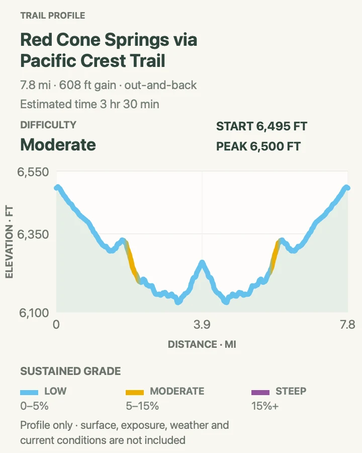
Red Cone Springs via the Pacific Crest Trail
- Distance
- 7.8 mi
- Elevation gain
- 610 feet
- Time
- 3 hr 30 min
- Difficulty
- Moderate
- Route type
- out-and-back
- Parking
- Begin at the North Entrance/PCT access area only where legal parking is open and not obstructing road operations.
- Best time
- Late summer or early fall after snowmelt and before the North Entrance closes for winter.
- Pets
- Pets are not allowed on park trails. Trained service animals are allowed.
This out-and-back uses the Pacific Crest Trail to reach Red Cone Springs, passing lodgepole forest and pale pumice flats well away from the caldera overlooks. It offers the rhythm of a backcountry walk without committing to the PCT's entire park traverse.
The spring area is a designated backcountry campsite, not a guaranteed drinking tap. Treat any collected water and confirm whether the source is flowing before depending on it. Mosquitoes can be intense after snowmelt, while late-season dryness shifts the main concern to water supply.
What helps on this route
- Carry enough water to return even if the spring is dry or unsuitable.
- Yield to thru-hikers and keep food secured; camping requires a backcountry permit.
Terrain and access: Pacific Crest Trail tread, forest, open pumice flats, rolling grades, minimal landmarks, and a remote spring area.

Official planning sources
Trail access and safety details were checked against these National Park Service pages. The maps and profiles use the reviewed route geometry stored with this guide.
Map data © OpenStreetMap contributors. Trail geometry and planning details include National Park Service public information.