8 Best Hikes in Great Sand Dunes National Park
Eight Great Sand Dunes hikes across creekside forest, open sand, the mountain foothills, and two alpine lakes, with reviewed maps, profiles, and live park alerts.
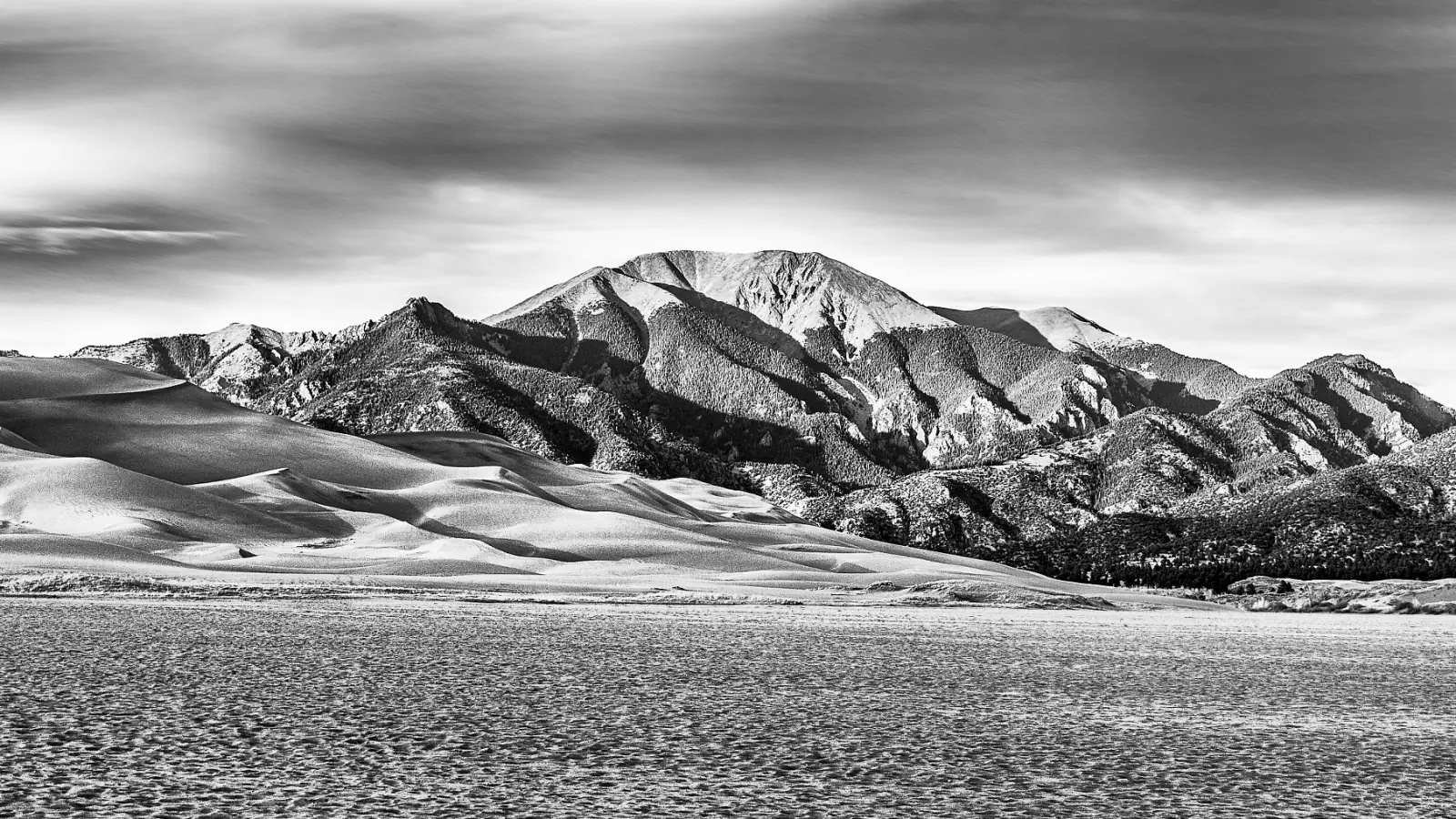
Great Sand Dunes is a strange place to measure a hike. A mile on firm forest tread and a mile of loose sand are barely the same activity, while the park's alpine trailheads can sit two hours of mountain driving from the famous dune parking lot.
These eight walks cover that range without pretending every line across the sand is a separate trail. High Dune is the short, steep introduction; Star Dune is the serious open-sand day. Mosca Pass and Sand Ramp move into forest and foothills, while Medano Lake and Upper Sand Creek Lake belong to visitors prepared for rough road access, altitude, and a full mountain outing.
As of late August 2026, Medano Pass Primitive Road is open, but deep soft sand between Castle Creek and the first creek crossing is trapping vehicles. The park requires true high-clearance four-wheel drive with low range beyond Point of No Return. The 2026 water year is also one of the driest on record locally, and Medano Creek is not flowing at the main dunes parking area. Check the live park page again on the day you travel.
What changes a hiking day here
Cross the dunes before the afternoon
Summer sand can reach 150 degrees Fahrenheit, and July or August storms put exposed hikers in lightning country. Start dune routes near sunrise, wear closed-toe shoes, and return to a building or vehicle when thunder begins.
Expect the route to move
There are no built trails in the dunefield. Ridges change with wind, creek flow changes the approach, and a straight GPS line can be harder than a longer route that follows firm sand. Keep the parking area or a fixed mountain bearing in view.
Separate paved access from mountain access
The main dune lot, Mosca Pass, and Piñon Flats are reached by paved park roads. Medano Lake requires the primitive 4WD road. Sand Creek Lakes are approached from Music Pass, a long drive around the mountains with a final road segment that changes with vehicle clearance.
Read the pet map before choosing a route
Leashed pets are welcome in Mosca Pass, the preserve, and specified frontcountry areas, but they cannot continue beyond the first high dune ridge or onto the northern Sand Ramp Trail. Hot sand can burn paws long before the air feels extreme.
| Trail | Distance | Time | Difficulty | Best for |
|---|---|---|---|---|
| Wellington Ditch Trail | 2.3 mi | 48 min | Easy | A short historic walk with broad dune views |
| Mosca Pass Trail | 7 miles | 4 to 6 hours | Moderate | Creekside forest and a full walk to a low mountain pass |
| High Dune on First Ridge | 2.5 miles | 2 to 4 hours | Hard | The classic first panorama across the entire dunefield |
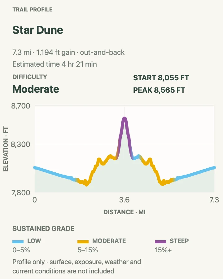
| Star Dune | About 6 miles | 6 to 9 hours | Hard | A long, navigational climb to the park's great pyramid-shaped dune |
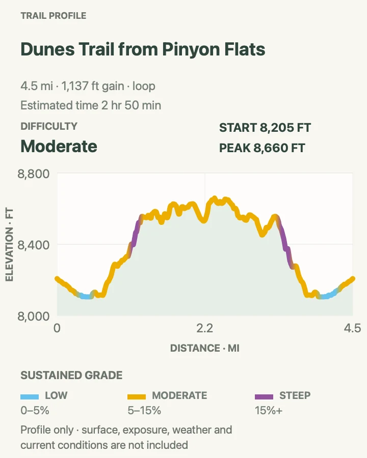
| Dunes Trail from Piñon Flats | 4.5 mi | 2 hr 50 min | Moderate | A quieter campground-to-dunes circuit |
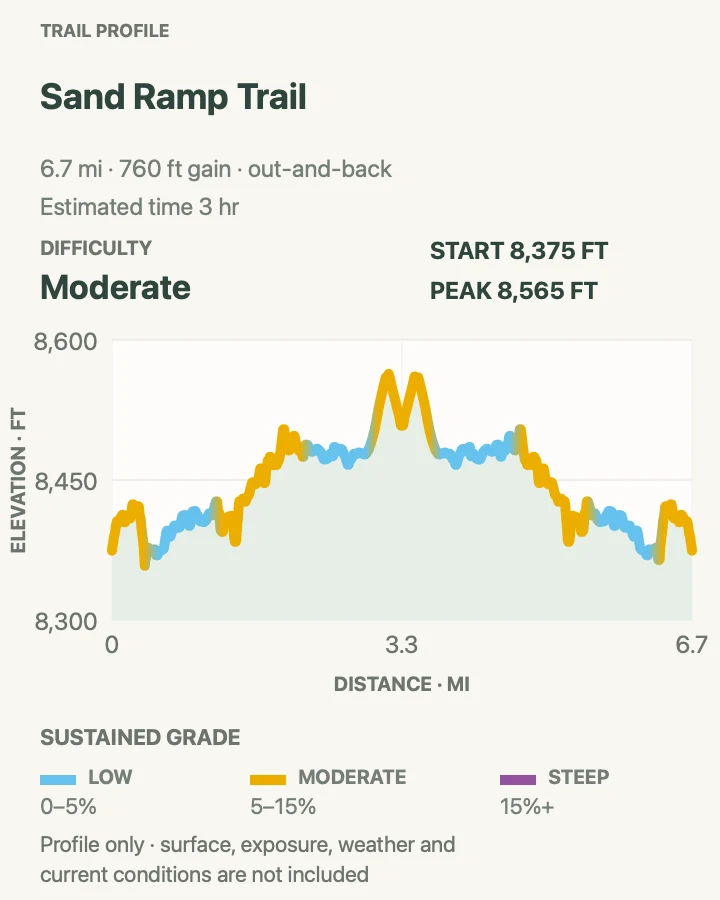
| Sand Ramp Trail | 6.7 mi | 3 hr | Moderate | Sandy foothills and a taste of the park's backpacking corridor |
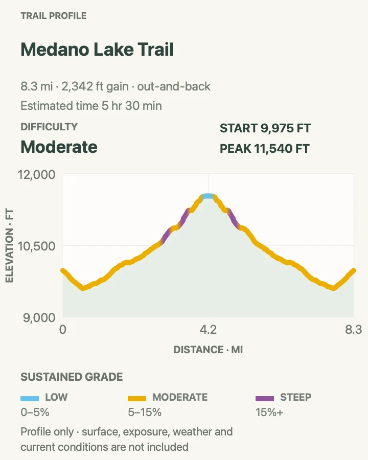
| Medano Lake Trail | 8.4 mi | 5 hr 30 min | Moderate | Meadows, forest, and a high alpine lake below Mount Herard |
| Upper Sand Creek Lake | About 8 miles | 5 to 7 hours | Hard | A remote alpine basin reached from the far side of the range |
Wellington Ditch Trail
- Distance
- 2.3 mi
- Elevation gain
- 140 feet
- Time
- 48 min
- Difficulty
- Easy
- Route type
- out-and-back
- Parking
- Use the Mosca Pass trailhead lot near the main dunes area and follow signs for the short ditch route.
- Best time
- A cool morning or late afternoon when the open sections are comfortable.
- Pets
- Leashed pets are permitted in this frontcountry area; keep the leash six feet or shorter and carry out waste.
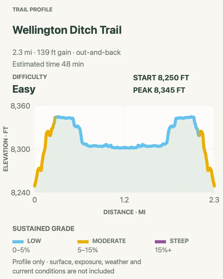
Wellington Ditch follows an old watercourse above the main visitor corridor. Its easy grade gives newcomers a first look at the meeting of grassland, forest, sand, and the Sangre de Cristo Mountains without committing to a dune climb.
The route is simple, but shade is uneven and the soil can be dusty. Old ditch banks crumble under shortcuts, so remain on the used tread and turn around at the mapped endpoint rather than following faint utility traces.
What helps on this route
- Pair it with Mosca Pass only if the weather remains cool and clear.
- Bring binoculars for the open views instead of leaving the trail for a closer angle.
Terrain and access: Mostly gentle dirt tread, old ditch grade, dry grassland edges, scattered shade, mountain views, and a few eroded banks.

Mosca Pass Trail
- Distance
- 7 miles
- Elevation gain
- 1,410 feet
- Time
- 4 to 6 hours
- Difficulty
- Moderate
- Route type
- out-and-back
- Parking
- Park at the signed Mosca Pass trailhead reached by the paved main park road.
- Best time
- Morning from late spring through fall; September brings cool air and changing aspens.
- Pets
- Leashed pets are permitted on Mosca Pass Trail; use a leash no longer than six feet.
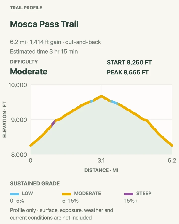
Mosca Pass climbs beside a small creek through aspen and evergreen forest to a broad crossing of the Sangre de Cristo range. The park gives 3.5 miles each way and two to three hours for the ascent, which makes the pass a substantial half-day rather than a casual extension of the nature trails.
The forest makes this a sensible alternative when exposed sand is too hot. Afternoon storms still reach the pass, and legal hunting occurs in the preserve during fall seasons. Bright clothing is prudent when those seasons are open.
What helps on this route
- Save enough water for the return even though the route follows a creek.
- Treat surface water before drinking and step aside carefully around wet vegetation.
Terrain and access: Creekside dirt trail, aspen and conifer forest, steady moderate climbing, roots, seasonal mud, pass exposure, and about 1,400 feet of ascent.

High Dune on First Ridge
- Distance
- 2.5 miles
- Elevation gain
- 760 feet
- Time
- 2 to 4 hours
- Difficulty
- Hard
- Route type
- out-and-back
- Parking
- Begin at the main Dunes Parking Lot and cross the Medano Creek bed toward the first high ridge.
- Best time
- Sunrise or early morning before hot sand, wind, and thunderstorms develop.
- Pets
- Leashed pets may use the main day-use dune area as far as the first high ridge; protect paws from hot sand.
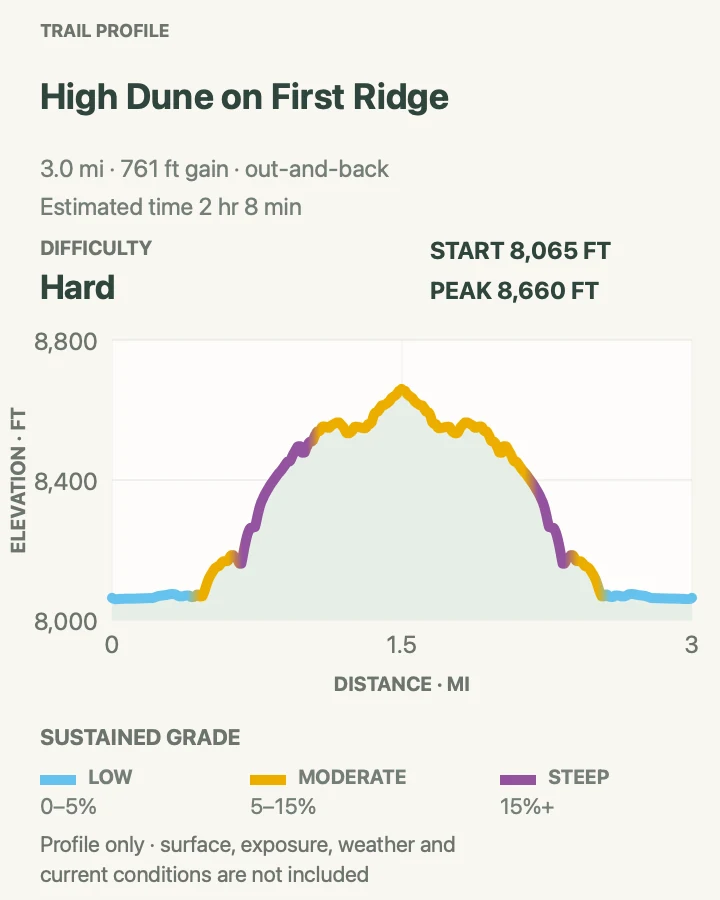
High Dune looks like the park's summit from the parking lot, though taller dunes stand farther inside the field. The climb gains roughly 688 feet in loose sand and has no fixed trail. Aim for ridgelines, zigzag when the slope steepens, and expect the return line to differ from the ascent.
The park estimates about two hours for an acclimatized hiker but warns that the round trip can take twice that. At 8,200 feet and above, soft sand exposes a fast start. A steady pace works better than repeated sprints up each slipface.
What helps on this route
- Use the mapped summit coordinates as a reference, not as a command to cross every steep face directly.
- Leave the ridge at the first thunder; the open sand has no shelter.
Terrain and access: Unmarked open sand, creek-bed crossing, repeated loose ridges, steep slipfaces, full sun, wind, altitude, and lightning exposure.

Star Dune
- Distance
- About 6 miles
- Elevation gain
- 1,190 feet
- Time
- 6 to 9 hours
- Difficulty
- Hard
- Route type
- out-and-back
- Parking
- Start at the main Dunes Parking Lot and use the Medano Creek bed to approach the dune from the south.
- Best time
- A very early start on a cool, stable day; avoid summer afternoons completely.
- Pets
- Pets are not permitted beyond the first high ridge of the dunefield, so they cannot accompany this full route.
Star Dune rises 736 feet from base to summit and is now measured as the second-tallest dune in North America. The direct approach follows the creek bed south for roughly two miles until the pyramid form is obvious, then climbs a ridge to the top. There is no trail.
This is a different undertaking from High Dune. The approach is longer, the sand may erase footprints, and the NPS warns that popular third-party routes can be inaccurate. Turn around if heat, wind, thunder, or uncertainty begins to eat into the return margin.
What helps on this route
- Record the parking-lot bearing before entering the ridges and carry an offline park map.
- Pack more water and food than the six-mile figure would suggest on a firm trail.
Terrain and access: No constructed trail, broad creek bed, loose dune ridges, steep sand, long exposure, route finding, altitude, and no shade or reliable water.

Dunes Trail from Piñon Flats
- Distance
- 4.5 mi
- Elevation gain
- 1,140 feet
- Time
- 2 hr 50 min
- Difficulty
- Moderate
- Route type
- loop
- Parking
- Park within Piñon Flats Campground only in an authorized space; day visitors should confirm campground parking rules before starting.
- Best time
- Early morning or a calm evening outside peak campground traffic.
- Pets
- Pet access is restricted outside designated frontcountry corridors; check the current pet map before bringing a leashed animal on this circuit.
This circuit leaves the campground edge, crosses sandy woodland, and reaches the lower dunefield before bending back toward Piñon Flats. It trades the main parking-lot crowd for a less direct approach and a stronger sense of how the dunes meet the foothills.
The line across sand is not maintained or signed like a normal loop. Wind can cover tracks within minutes. Keep the campground and mountain wall as reference points, and do not cut through occupied campsites on the return.
What helps on this route
- Confirm where day parking is allowed if you are not staying in the campground.
- Carry a headlamp for an evening circuit; dunes make a slow finish after sunset.
Terrain and access: Campground paths, sandy woodland, unmarked lower dunes, shallow ridges, exposed sun, shifting tread, and route-finding between fixed landmarks.

Sand Ramp Trail
- Distance
- 6.7 mi
- Elevation gain
- 760 feet
- Time
- 3 hr
- Difficulty
- Moderate
- Route type
- out-and-back
- Parking
- For this shorter segment, start at Point of No Return on the open two-wheel-drive section of Medano Pass Road; the trail also begins in Loop 2 of Piñon Flats Campground.
- Best time
- A cool morning in spring or fall, or early summer before heat and storms build.
- Pets
- Pets are not permitted on Sand Ramp Trail north of Point of No Return.
Sand Ramp runs along the foot of the mountains rather than climbing a scenic summit. The selected out-and-back samples the southern portion from Point of No Return, where woodland gradually gives way to deep sandy tread and views along the eastern edge of the dunes.
The complete trail is eleven miles one way and mainly serves backcountry sites. Even this shorter version feels slow after the first two miles because the footing becomes loose and repeatedly rises and falls. Set a turnaround time instead of chasing an arbitrary junction.
What helps on this route
- Do not confuse a quiet corridor with an easy one; loose sand sharply reduces pace.
- Overnight camping requires a permit and use of the assigned backcountry site.
Terrain and access: Foothill woodland, rolling sandy soil, sections of pure sand, limited shade, backcountry junctions, and slower travel than the mileage implies.

Medano Lake Trail
- Distance
- 8.4 mi
- Elevation gain
- 2,340 feet
- Time
- 5 hr 30 min
- Difficulty
- Moderate
- Route type
- out-and-back
- Parking
- Reach the Medano Lake trailhead only by the seasonal Medano Pass Primitive Road in a legal high-clearance 4WD vehicle with low range.
- Best time
- Mid-summer through early fall after snowmelt, with an early start and stable forecast.
- Pets
- Leashed pets are permitted in the national preserve; keep them under control around wildlife and livestock.
The trail starts near 10,000 feet and climbs about 2,000 feet through forest and wet meadows to a lake at timberline. It is the most direct alpine-lake outing on this side of the preserve, yet reaching the trailhead can be as consequential as the hike.
NPS reports that tree downfall may cover sections of the alpine routes. Snow can remain into summer, and a clear morning can turn into an exposed thunderstorm near the lake. Mount Herard is a separate advanced extension, not part of this eight-mile lake day.
What helps on this route
- Check road, creek-crossing, snow, and downfall reports before leaving pavement.
- Turn back below timberline if thunderheads are building over the pass.
Terrain and access: Remote 4WD access, high-elevation forest, wet meadow, possible deadfall, lingering snow, 2,000 feet of climbing, and open alpine shore.

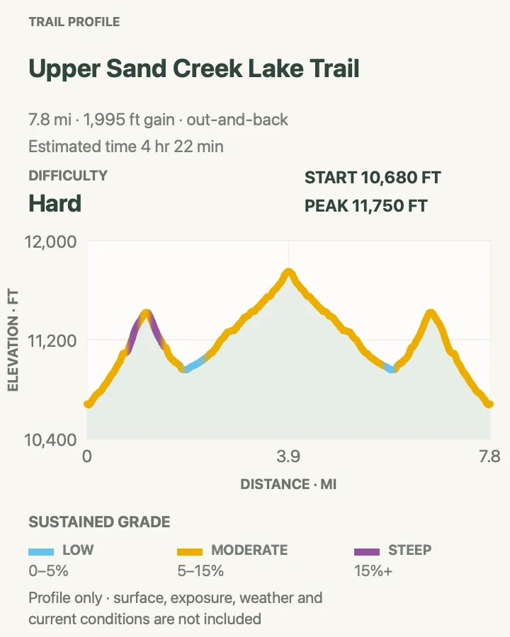
Upper Sand Creek Lake
- Distance
- About 8 miles
- Elevation gain
- 2,000 feet
- Time
- 5 to 7 hours
- Difficulty
- Hard
- Route type
- out-and-back
- Parking
- Approach Music Pass from the Wet Mountain Valley side; two-wheel-drive vehicles may need to park 2.5 miles below the upper trailhead.
- Best time
- Mid-July through early fall after snow and high-water crossings ease.
- Pets
- Leashed pets are permitted in the preserve, subject to adjoining national forest rules on the approach.
Upper Sand Creek Lake is an alpine trip whose logistics are easy to underestimate. From the upper Music Pass trailhead, the lake outing is about eight miles round trip, but the drive from the visitor center takes roughly two and a half hours. A low-clearance car can add five road miles to the walk.
The trail crosses Music Pass, drops toward Sand Creek, and climbs into the lake basin. Snow may block travel from November into June, while summer storms gather quickly above timberline. Ask a ranger about creek crossings and recent trail condition before making the long approach.
What helps on this route
- Do not let a navigation app route a passenger car onto a primitive mountain road.
- Carry enough food, water treatment, and storm layers for a delayed return.
Terrain and access: Long remote road approach, mountain pass, forest descent and climb, creek crossings, alpine basin, possible snow, and limited emergency response.

Official planning sources
Trail access and safety details were checked against these National Park Service pages. The maps and profiles use the reviewed route geometry stored with this guide.
- NPS: Current conditions and 2026 alerts
- NPS: Dune, forest, and alpine hiking
- NPS: Medano Pass Primitive Road status
- NPS: Heat, altitude, wind, and lightning safety
- NPS: Monthly trail and creek conditions
- NPS: Medano Creek conditions
- NPS: Where pets are permitted
- NPS: Official maps and road cautions
- NPS: Backcountry permits and Sand Ramp Trail
Map data © OpenStreetMap contributors. Trail geometry and planning details include National Park Service public information.